Showing posts with label idleyld park. Show all posts

Wednesday, January 22, 2020

Fall Creek Falls

Oh, what an effete snob I am! "This hike is too small" and "this hike is too large" and I'm not sure I've ever found a hike that is just right. Because the walk (I deign to call it a hike) to Fall Creek Falls lands in the too-short category, that would be why I've only hiked there just once, and that was back when I was a single parent and the kids were small. But the opportunity to get out with friends I hadn't seen in a while cropped up, so I decided to be more tolerant and accepting, and take the namby-pamby "hike" to the falls. And hey, I can always take a small walk and turn it into a big photo shoot in the hiking equivalent of making mountains out of molehills.

Slow shot of a fast creek
So, inclining my head towards the horizon so as not to snootily look down my nose at this tiny stroll, I joined Jennifer, John, Dianne, and Connie for the amble to the falls. Right at the start, it was obvious this would be all about the creek. It had been raining off and on during the week, filling up the North Umpqua River and all its tributary streams (of which, Fall Creek is one) with water. That would explain why the creek was so noisy and vociferous as it bounded from pool to pool below the trail. I don't think there was any other color to the water besides white. 

Green and white all day long
The hike was bichromatic as colorwise, there was only the white of the creek and the green of literally everything else. The falls and creek fill up the narrow canyon with moisture, providing watery sustenance to all the thriving ferns, moss, trees, lichen, and other assorted vegetation. Since this was a short walk-cum-photo shoot, I set out to photographically document everything I saw growing and flowing around the trail. Didn't take long, naturally, for me to find myself walking solo, lagging well behind my camera-free comrades.

Trail shot 
A point of interest on this trail, besides the waterfall, is a large house-sized rock squatting on the trail like an oversized mossy river troll. It probably fell eons ago from the slopes above and when it did fall, it cracked in two like a geologic Humpty-Dumpty. Nowadays, the split between the two halves of what used to be one whole is the actual trail. The narrow cleft is not a place for those who dislike confined spaces and reminded me I really should start my diet soon. Back in the day, my children thought it was the coolest thing ever to run back and forth through the rocky confine.

Fall Creek Falls
After a green mile with the whitewatered creek churning next to the trail, a larger roar began to permeate through the forest. Yup, it was Fall Creek Falls, in all its thundering glory. Using the shoot-and-wipe technique, which consists of hurriedly snapping a photograph and then wiping off the ample moisture from the falls that managed to accumulate on the lens' surface (on my glasses too, I might add) in the 1/100th of a second that it took for the camera shutter to trip. Not really done hiking (it had been just over a mile, I think) at this point, I continued on the trail as it headed up to a trailhead above the falls, but not before stopping at a viewpoint with a bench to admire the falls some more. 

Fall Creek was always reliably photogenic
The trail ended at a gravel road and I knew that Jennifer and John had continued hiking on the road for extra mileage but in which direction? Not sure and not wanting to confuse my people as to my whereabouts, I dallied where the roadway crossed Fall Creek. The creek was particularly photo-friendly here where it streamed in a series of attractive stair-step cascades and pools. After a bit, Diane popped out from the trailhead and pointed me in the right direction and the two of us continued hiking along the gravel road.

It's starting to rain
The air had that liquidity that hovered somewhere between drizzle and rain. Clothing got soaked in no time at all despite the lack of direct inclemency. Liquid weather must occur a lot up here, for the surrounding forest was covered in thick layers of fern and ever-present moss. The forest understory greenery was just that: eminently green everywhere, broken up only by occasional mossless tree trunks. Puddles reflected the surrounding branches and dark clouds, and before long, concentric ripples on the puddles told us it was starting to sprinkle, as if the pitter-patter sound on hat brims were not clue enough.

Raindrop on a cedar frond
So back toward the trail was the direction in which we went, and I fitted an extension tube (used for taking macro photos) onto my camera and figured I'd just take photos of small things. It's what you do on a short hike. Accordingly, I now have lots of photos of lichen, moss, mushrooms, water drops, and witch's butter (a yellow-orange fungus that resembles a dollop of butter). As Diane and I snacked in the wet atmosphere above the falls, Jennifer and John appeared and the four of us headed back down the muddy trail. Since this was more photo-shoot than walk, I soon found myself in my customary spot all alone, way behind everybody else. But to be honest, I re-enjoyed the trail all over again since my last visit here several decades ago. So much so, I might even quit looking down my nose at all the other little unworthy trails but then again, probably not.

Fall Creek emerges from its lair
For more photos of this hike, please visit the Flickr album.


Sunday, September 16, 2018

North Umpqua Trail - Tioga Segment

The last couple of years, backpacking the 79-mile North Umpqua Trail (or NUT) had been on the calendar for a grand summer adventure. And in the last couple of years, forest fires have ensured that I hike somewhere else other than on the North Umpqua Trail. However, the 2017 North Umpqua Fire was a doozy, hanging around the North Umpqua River (and trail) for most of the summer, smothering Roseburg in thick choking smoke for the duration thereof. After that fire, the North Umpqua Trail was closed for quite some time while the Forest Service cleared the trail of downed trees, replaced bridges, and put new trail in over landslides. Just recently, the closed sections of the NUT had been reopened, giving us hikers an opportunity to assess the damage.

Now, I've always found burn areas to be beautiful in their own way. Acres and acres of silver snags point upward to a blue sky, pleasing both eye and camera; small songbirds twitter and flitter about; woodpeckers jackhammer the dead trees; and fireweed explodes in flowery exuberance on the forest floor. But, to be honest, I usually hike the burn zones long after the fires have subsided. This would be a rare opportunity to explore a fire-charred forest within a year of the last flames being extinguished.

In case I didn't know or notice
Luna (my dog) and I set out on the trail under gray and threatening sky. It had rained on the drive to the Wright Creek Trailhead but for the moment, the rain let up. What did not let up was Luna's compulsion to be be the one in front. I had to continually assert myself as the Alpha Dog, which I did by extending my hiking pole sideways, blocking her way to the front of the line, lightly rapping her on the nose and noggin should she not get the hint. Relentless, she started bushwhacking up and around the reach of those pesky and irritating titanium dog-smacking hiking poles. If this keeps up, electricity will soon be involved when we hike.

The undergrowth already is reclaiming the forest
But this is not a dog-training blog, and enough already about my canine-related travails. At the trailhead, a brand new sign warned of falling rocks and debris, due to the recent fire. And just in case all the dead trees weren't clue enough, the sign also advised we were about to enter a burned area. Undeterred by the warning, we headed up the trail and it was immediately apparent that death would be the theme of the day. Miles and miles of dead and scorched trees, not yet going photogenically skeletal white. You could almost still smell the smoke, and the ground was covered by a layer of dry pine needles dropped from dead or dying trees. The gray and overcast sky matched the mood perfectly.

Rain on oxalis
Despite the destruction wrought by the fire, there was still plenty of life to be found. The undergrowth was vigorous and robust, consisting of fireweed, wild rose, candy flower, vanilla leaf, and wild ginger, just to namedrop a few. Dense carpets of oxalis covered the damper segments of trail, with water drops beading on the clover-like leaves in camera-pleasing fashion. Unfortunately, the increased sunlight due to the lack of trees led to a robust outburst of poison oak but at least the leaves were turning red, imparting a hint of autumn to the trail. Nothing kills poison oak, not even an immolating forest fire.

How madrone survives fire
Fire is a part of the cycle of life of a forest and it was interesting to see how the trees handled the fire. Madrone sends up new growth from its roots and it was quite common to see green shoots circling the base of a dead or dying tree. The thick bark of the Douglas fir is the first line of defense from the heat of a fire and larger trees had blackened trunks but green tops, while younger trees did not survive the fire at all.

What was this guy doing in a burn zone?
There wasn't much in the way of wildlife in the unusually quiet forest, apart from a few twittering birds. Didn't see any sign of elk, deer, bear, or scat thereof on the trail. I have no doubt though, that come next spring, the forest will nevertheless be populated by an overwhelming population of mosquitoes and poison oak bushes. Hmm, maybe things that make you itch are resistant to all potential mechanisms of extinction, including a searing forest fire. That therory would also bode well for ticks, regrettably. However, most surprisingly, I did encounter a forest snail slithering on the trail. How on earth did that snail survive the fire?

Thunder Creek, on its way to the North Umpqua River
At about the two mile mark, Thunder Creek came into view, waterfalling down the steep slope as the creek tumbled toward the mostly hidden North Umpqua River.  Amazingly, the wooden bridge spanning Thunder Creek had survived the fire intact and untouched. No doubt, humidity from the creek played a significant part in the preservation of the rustic footbridge. The creek was not thundering much, as it was running low this late into summer. From the creek crossing, the NUT then headed uphill to the first of two rocky points of interest.

View of the fire-damaged forest
The first point required a bushwhack over burned and fallen trees to a rocky overlook of the North Umpqua River canyon. The river was maybe a hundred feet below but just one step away, if one were so inclined or careless enough to do that. We weren't so inclined, so we stayed safely in the middle of the promontory, my hand firmly holding onto the dog leash. I am the Alpha Dog, remember? On the crown of the point, several madrones were severely singed yet their crowns still were a leafy green, with orange limbs and trunks interwoven into a dense tangle beneath the leaves. Looking down the canyon, the forest was a patchwork quilt of live and dead trees. That was kind of surprising, because from our firsthand experience, it seemed like it was all dead forest when hiking through it.

This bench survived while surrounding bushes did not
Continuing on further, we hiked to a more prominent point referred to as Elevation Rock by my hiking crowd, although it is nameless on the map. This overlook served up an epic view of the North Umpqua River curving around a bend, with the North Umpqua Highway following the river on the opposite side. No, this is not your remote and isolated wilderness hike. The forested hills surrounding the canyon all disappeared into the cloud cover as we sat on a bench and ate lunch. The aforementioned bench has always been one of my favorite benches and I was overjoyed to see that it too, had survived the fire.

Old wasp nest on the trail
By this time, I really had gotten tired and irritated at having to continually assert my dominance over one of the most bone-headed life forms on this planet. I would have let Luna loose, but she has no filters and is liable to disappear off trail in search of a squirrel or swim, or maybe a squirrel and a swim, or a swimming squirrel even. My option was to continue the fight for another 1.5 miles of trail down to Fox Creek, or give up the venture for now. Not sure what this says about my Alpha-Doggedness, but we cut the hike short and headed back to the car, happy with a short 6 mile hike.

Itchy, itchy!
So, back down the trail we went, this time stopping to photograph the red poison oak leaves. I felt sort of unclean and itchy doing that, but I'm glad to report that my camera did not develop a skin rash within a week of this hike. If there was any justice in  this world, mosquitoes would bite poison oak leaves and both life forms would then know of the itchy madness they spread. But alas, there is no justice in this world, and I'm sure they will both be waiting for me when I finally get to backpack the North Umpqua Trail.

Pine needles covered all
For more pictures of this hike, please visit the Flickr album.


Friday, March 9, 2018

North Umpqua Trail - Panther Segment

Sometimes, you just have to be in the mood and clearly, I wasn't. The rain was pouring down and the temperature was cold, hovering just this wet side of snowfall. That was cause enough for me to throw up my hands and whine "I just want to go home". And after a paltry 4 miles of hiking, I did that very thing, much to the disappointment of my canine companion, Luna. Its really too bad, because visually, this is a beautiful hike and on a slightly less belligerent day, the hike would be as eminently enjoyable as a homemade enchilada.

Wild ginger flower
March comes in like a panther and out like a lion, or something like that, and this March was no exception, snarling and screeching in with a series of rainstorms that really tested one's resolve to hike every weekend. On this particular Friday, the morning dawned dark and gray with a steady stream of fat raindrops pattering against the living room windows. I really didn't feel like hiking in that crap but figured if I could just get  out to the trailhead then the joy of hiking would rekindle the smoldering embers inside my hiking heart, just like it always does. I was wrong.

Even on a rainy day....
Luna was game though, and bounded up the North Umpqua Trail in unrestrained ebullience that quickly resulted in her getting leashed for the remainder of the hike. She has no filters and the forest has so many squirrels in it. As we set out upon the trail, the rain was tapping out a steady drumbeat on my hat brim, and we were surrounded by the three-dimensional aural hiss of rain falling throughout the forest.

A small piece of the North Umpqua River
The Panther Segment of the North Umpqua Trail spends a lot of it's miles high above the North Umpqua River, and started out by immediately charging uphill to get up there. In no time at all, I was sweltering underneath my raincoat, despite the chilly weather. The turquoise color of the river, muddy and silted with increased runoff, could be seen here and there between the trees in the dense forest. 

Soggy and happy
Despite the wintry vibe, spring is definitely here. Lavender sprigs of snow queen were abloom everywhere and one ugly brown wild ginger flower was spotted by your merry blogster. On mossy cliffs with rain dripping off everything, happily soggy (or is it soggily happy?) saxifrage plants were offering up small white flowers as sacrifice to the rain gods. 

Sun, please stay longer than 30 seconds
At the crest of a rather vigorous climb, the sun actually came out and I could almost hear a choir of angels sing as a sunbeam lit up the trail. I stopped to take off layers and jackets but before I could actually consummate that task, the sun disappeared and the rain resumed. That was such a tease!


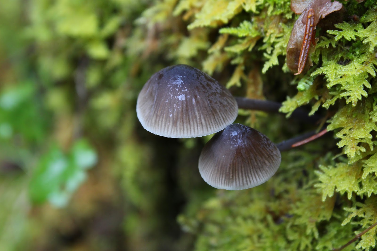
Mushrooms in the moss
One of the many things I like about the North Umpqua Trail is the rampant greenery along the trail. The river canyon traps humidity and the forest is amazingly lush. Mushrooms sprout on trees, ferns and Oregon grape carpet the forest floor, and moss covers all inanimate and sedentary objects. Today was no different and much photography ensued.

One of a million creeks crossing the trail
The rain had all manner of creeks and streams cascading down the forested hillsides and I daresay boots got wet as I waded where they crossed the trail. But the rain was really coming down by now, and enthusiasm by the human half of our hiking contingent was waning. At the 1.9 mile mark, a fallen tree cinched the deal.

Some of that winter blowdown
The tree was over waist-high and lay perpendicular across the trail, effectively blocking the way. Luna hopped on the log and promptly skidded and slid down the inclined trunk before hopping off about 10 yards downhill. I declined the opportunity of repeating her experience. Half the tree was uphill which would have required an extremely tedious and muddy bushwhack up and around a sizable root ball. And on the downhill side, the upper half of the tree lay on a steep slope covered with riverine jungle. Good enough for me on this wet day, and we turned around.

Sun again, for thirty seconds, again
On the way back the sun came out again, just enough for me to feel bad about turning around. And then it was never heard from again as incessant heavy rain started up for good. I figured that when we made it back to the trailhead, we could continue hiking on the Calf Segment for some decent mileage.


Panther Creek runs into the North Umpqua


However, the Calf has been burned up in several forest fires over the last decade and accordingly, there is not much in the way of trees flanking the trail. We were totally exposed to the elements and the Calf Segment demonstrated the difference between rain falling in forest and the totally unfiltered version of the same rainstorm. That was it, no more hiking for the day; so back to car we went, figurative tails between our legs. You just have to be in the mood, and I wasn't.

British soldiers in the moss
For more pictures of this hike, please visit the Flickr album.


Sunday, March 4, 2018

North Umpqua Trail - Swiftwater Segment

Bit by bit, springtime is coming! Sometimes its hard to believe, like when copious amounts of rain fall on the deck outside. Drive up the North Umpqua Highway to about 3,500 feet of elevation while your car slips and slides in the ice and snow, and it'll still feel a lot like winter. But in between the ample precipitation leaking from the sky, there are signs here and there that winter is on the way out. Occasionally, sunlight breaks out and the temperatures are at least 10 degrees warmer than it had been most of February. Twittering birds commence constructing nests in the branches while underneath the trees along the North Umpqua Trail, the diminutive lavender blooms of snow queen carpet the florest floor. Yes, I know that winter will have a thing or two yet to say about the arrival of it's seasonal arch-nemesis, but it sure was nice to hike on the North Umpqua Trail without getting frozen or soaked for a change.

Woodland violet
So, the day was not great but on the other hand it wasn't raining...too much, anyway. That was good enough for Luna and I, we saddled up and drove over to the Susan Creek Day Use Area for some winter/spring hiking. As we started, the trail was blocked by a large fallen tree lying across the trail. After a quick scramble over the dearly demised tree, we had to stop again to take pictures of some of the many clumps of snow queen blooming next to the trail. Oh, and there was some woodland violet and twinflower too, which required more lying prone in wet vegetation, snapping a few dozen photos of every flower. Well, to be exact, Luna waited patiently for me while I did my photography thing and I could sense much rolling of eyes behind my back when I wasn't looking.

Tick-harvesting hiking companion
A half-mile and a half-hour later (thanks to the snow queen), we crossed the North Umpqua River on the always picturesque Tioga Bridge, the orange wood of the bridge contrasting nicely with the turquoise waters of the rain-swollen river. Luna too contrasted with most everything, since she is entirely black except for the one patch of white on her throat and chest.

Moss creeps over a bald spot
Once across the river, there were two options for hiking: right turn or left turn. The left-turn version would be on the Tioga Segment of the North Umpqua Trail, but a sign warning of a trail closure several miles ahead cinched the deal. "Not Closed": I like that in a trail, so right on the Swiftwater Segment it was. The Tioga Segment had been ravaged by wildfire last summer and the Forest Service is rightly concerned about landslides and falling trees, plus no doubt most of the wooden bridges were burned up in the fire, too. I'm not averse to getting my feet wet but some of those little ravines would be quite tedious to get across without a bridge spanning them. And as tempting as it is to hike past the closure signs and explore the wild post-fire scenery, there is a hefty fine involved if you happen to be caught and cited. In my post-retirement budget, there is not enough room for a "stupid-tax".

Lots of water in the forest


The Swiftwater Segment was fine though, as it angled gently uphill on an old gravel road bed for most of the first three miles. The vegetation was lush and water soaked, my legs would have been sopping wet had we had to hike on a real trail with encroaching vegetation. We had to endure several short rain showers and I had plenty of opportunity to take photographs of water drops dangling off of branches, leaves, and runny noses.

A small creek crosses the trail
With all the rain coming down in the last week, it stood to reason there'd be plenty of water running in all the seasonal unnamed creeks crossing the trail. And yup, there certainly was and I have hundreds of photographs to prove it. At this rate, we'd spend all day on the trail just to attain one mile of hiking distance!

Moss creeps over a rock


The forest bryophytes (that would be a fancy term for moss, dearies) were on full display here on the shady side of the river. Between the lush vegetation and the ample quantities of mossage (bryophytage?), green was the operative color on the North Umpqua Trail. Moss covers all that does not move, so Luna had no worries, but I had better put the camera away and hie myself smartly down the trail lest I too become just another indistinct green mossy lump in the forest.

So many creeks on the trail
As stated before, the trail was angling up and away from the river and the forest did a pretty good job of hiding the river from view. In several openings in the dense woods, we got rained on and we could see the bright turquoise color of the river water down below through the trees. Nonplussed by the rain, small birds flitted in the damp shrubbery like so many feathered ping-pong balls, attracting the attention of one easily distracted dog.

Snow queen


At about the three mile mark, we came across an area that had been logged right next to the trail. I have to think that the logging activity probably had some connection to last summer's wildfires, although the logging seemed to have occurred more recently than last summer. Civilization further intruded when the trail separated from the old roadbed and followed a not-so-attractive clear-cut beneath some power lines before ducking back into yet another lush forest.

Bob Creek
A short drop through the thick lichen-encrusted woods brought us to Bob Creek, it's footbridge still intact and untouched by fire. That was a logical turnaround point and we rested a bit and ate treats before turning back. On the way back the rain ceased and the sun broke out. There is a saying about Oregon "if you don't like the weather, just wait five minutes" There should also being some saying about experiencing summer, spring, fall, and winter all in one day, but that's just me whining.

Susan Creek
At any rate, in keeping with the adage cited in the previous paragraph, the rain returned by the time we reached the car at the end of a shortish 5.5 mile hike. More mileage was called for, so rain notwithstanding, we crossed the highway and resumed hiking on the Susan Creek Falls Trail, a short but heavily used path to the spectacular falls.


Susan Creek Falls on a rainy afternoon
The trail had been graded, graveled and fence-railed into submission and I get a little peeved when comparing this path to my normal ankle-twisting trail tread. But then it wouldn't really be hiking if all trails were like that, either, so I'll stop with the complaining. At any rate, Susan Creek Falls were predictably spectacular, particularly with the spring runoff increasing both the aural and water volume of the cascade. We didn't tarry long at the falls, for the rain was a little more insistent by now, it was just as well we turned back for the wonderful and heavenly warm air that can only be obtained from a car heater on a cold and wet, yet fine spring day.
.
The color of the river is amazing
For more pictures of this hike, please visit the Flickr album.


Saturday, February 11, 2017

Riverview Trail Loop

Sometimes, real life just gets in the way. At the end of January, a catastrophic illness suffered by my daughter Aislinn gave our family all the intrusion and reality one could ever not want. Naturally, hiking was not a priority during this ordeal but after several weeks, I took a temporary break from the whirring, beeping, and clicking of hospital machinery to hit the trail with my friends for some badly needed trail therapy.

Singing "Walk This Way" (Thanks Jesi, for that line)
One of Douglas County's many attractions is the North Umpqua Highway, an incredibly scenic and curvy road linking Diamond Lake and Roseburg. However, prior to 1964, travel to Diamond Lake took place on gravel North Umpqua Road. Whew, 70-plus miles of gravel road, that certainly was not a casual trip! Naturally, with the construction of the paved North Umpqua Highway in 1964, the old road sort of disappeared, either paved over by the new highway, consigned to the USFS forest road system, or simply swallowed up by the forest.

My people
An otherwise abandoned section of the old road now does duty as the Riverview Trail, currently delighting hikers and mountain bikers alike. The Riverview Trail generally stays high above the river and in places, provides even better views than the North Umpqua Trail on the other side of the river. The planned route on this Friends of the Umpqua hike was to follow the Riverview Trail to Fall Creek Falls for a moderate 8'ish mile hike. However, I had a lot of stress to work off so my plan was to depart the Riverview Trail at Bogus Creek Campground and return by way of the Mott Segment of the North Umpqua Trail for a more reasonable 12 mile hike. Mileage-addicted friends Lane and Kevin agreed to accompany me on the longer loop with dog Wish likewise agreeing to come along. 

Basaltic cliffs above the trail


The weather has been awful this winter but it was a rare sunny day that presented itself for this venture. The Riverview Trail is on the north side of the river so we actually walked in sunlight, a rare and wondrous occasion. Of course, the sunlight was for show only, as noses still ran in the wintry chill. The trail wasted no time in climbing a hundred feet or so above the river but once the altitude was gained, the path remained happily level for the most part.

Boots got wet at Alder Creek
Cliffs and basaltic pillars rose above the trail and moss filled in all the cracks in the imposing rock walls.  There was a large blue thing overhead and somebody thought it might actually be sky. I didn't think so because everybody knows the sky is gray. Occasionally, we enjoyed views down to the river and to the snow-dusted hills above. With all the recent rains, a fair number of creeks ran across the trail and boots got wet as we waded across. The route was open and exposed for the most part and we really enjoyed the delightful sensation of sunlight on skin.

So dark and cold at the bottom of the canyon
At approximately the four mile mark, Lane, Kevin, and I bid adieu to our friends and peeled off the Riverview, taking a path down to Bogus Creek Campground, currently closed for the winter. With a chorus of "Me, too!" we were joined by eager and naive newcomers Ezgi, Levi, and Ana. Welcome to a Richard Hike, kids! 

Where there is water, there is dog
A short road walk along the North Umpqua Highway delivered us to Wright Creek Bridge and just like that, we were on the other side of the river, ready to begin hiking on the Mott Segment of the North Umpqua Trail. We'd now be hiking on a real trail with dirt and everything, unlike the wide gravelly doubletrack of the Riverview Trail. It wasn't all happy miles however, as we were now on the shady south side of the river and the air was icy cold. Not much sun gets down to the bottom of the river canyon and mittens and extra layers of clothing were soon donned.

Fisher C
It was a pleasant six miles on the Mott, which spends most of its miles close to river level. I played professor to our three novices and had them all chewing on fragrant wild ginger leaves before long. At Fisher Creek, I pointed out Zane Grey's Camp and asked "Do you know who Zane Grey is?" With blank looks, the guesses I received in response were "Our new Vice-President? A Marvel Comic Book hero? Plays for the Chicago Cubs?" Sigh. The correct answer by the way is "...the world famous author who wrote novels of the American West". I'm glad nobody asked me what a novel was.

Small creek, large waterfall
About nine miles in, the bridge at Steamboat Creek hove into view on the other side of the river. Our car was parked there and it was so cruel to see the end of the hike so near but yet so far. We still had three miles of hiking to go because the trail crossed the river on the historic Mott Bridge, several miles upstream. It was here or thereabouts that I realized I had lost a little bit of my hiking trim with the month-long layoff. I perhaps should have eased back into the 12 mile thing instead of jumping all in at once.  

Sun on the North Umpqua
It was a pretty tired bunch that staggered to the finish, excepting Wish maybe. But on the plus side, I slept very well that night and it was nice to divest some stress and worry on a restorative hike.

The sun was so near, yet so far away
For more pictures, please visit the Flicker album.