Sunday, February 23, 2014

Yaquina Head

Quaint little Newport was a busy place during our visit. Turned out the population of little Newport had tripled overnight because of  the Seafood and Wine Festival. Presumably enough wine was drunk to stave off the effects of ciguatera (an illness caused by eating bad seafood), or at least it looked that way, judging by the overly boisterous and festive patrons in the restaurant we ate in. And Newport should be a happy place what with all the good food, good wine, and totally awesome scenery abounding in the Newport area. 

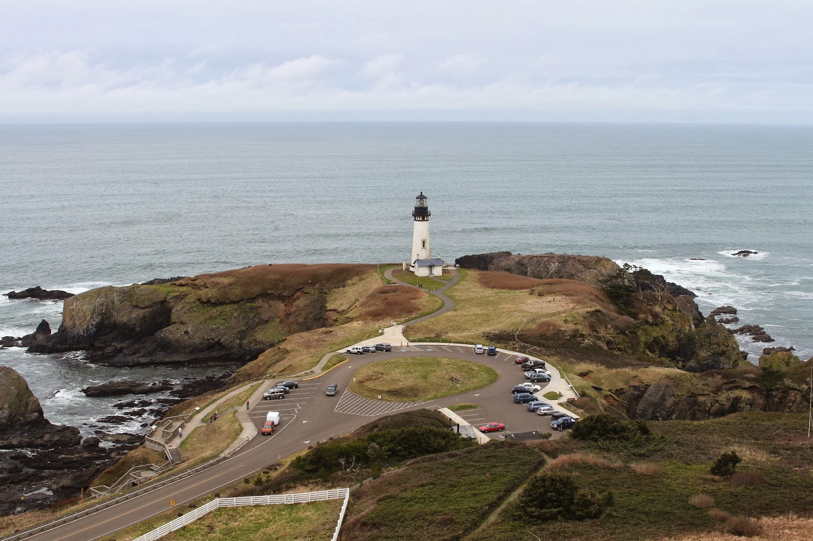
Yaquina Head Outstanding Lighthouse
And speaking of totally awesome scenery, Dollie and I got an early morning start at Yaquina Head. Amusingly, the official name for the head is not the Yaquina Head Natural Area but the Yaquina Head Outstanding Natural Area. Seriously, that's what the natural area is called. What's next: Crater Lake Super Dooper National Park? Boulder Creek Totally Awesome Wilderness?


Who made these tracks?
The track-making culprit
Over-the-top name aside, the scenery really is outstanding at Yaquina Head. Initially we had the entire place to ourselves, which might have been attributable to the wine portion of the Seafood and Wine Festival. We began our exploration of the Outstanding area by grabbing a very civilized paved and railed path down to Quarry Cove. Scooped out of the head, the quarry has been reclaimed by the sea and the rocks provided some great tide pools to explore.

Small cove on the head


There is an upper quarry above Quarry Cove which the visitor center now occupies. The scenery was sort of otherworldly with the modern building at the bottom of a sparsely vegetated, treeless and rocky bowl. The sea was hidden from view and it felt like we were on Mars. We grabbed another paved path that crossed under the roadway and returned us to Planet Oregon.

Great view with some surfer dudes in it
As we walked, views were awesome and expansive, the Oregon coast arcs gracefully past Newport to the Yaquina River, the rock jetty seemingly frail and delicate off in the distance. The bay was full of surfer dudes plying their passion as the waves marched in one after another.

Architectural detail 
A the end of the head sits the iconic Yaquina Head Lighthouse and it quickly became obvious this is where all the visitors go. A short path loops around the lighthouse and provided views of Moolack Beach stretching out all the way to Cape Foulweather (one of my favorite place names). At the foot of the head was a rock arch with the sea pulsing through it.

Stairway to the loud rocks


Below the lighthouse was a small beach comprised of round golf ball sized basalt rocks, the stones looking like a gigantic pile of fossilized rabbit poop. The sound the rocks made when people walked on them was something else, a loud clacking sound that reverberated from about a 15 foot radius from my boots. I wish they would have had these rocks on a couple of backpack trips I'd been on as the deer could never stealthily sneak into camp to steal hiking poles.

The slowest jailbreak ever
The main attraction at this little beach is not the noisy round rocks but the world class tide pools. It's a fairly civilized exploration of the pools as there are signs denoting walking boundaries and there is a nearby ranger posted to make sure nobody thinks the signs are dares. It sure was embarrassing when she yelled at me.


Nature's way of discouraging barefoot wading


The pools were filled with mussel beds and large starfish of various shades of orange and red were sprawled on top of the beds enjoying their own little Seafood Festival. Starfish eat by pushing their stomach out and then returning it back to the proper body cavity after getting sated. Now there's a new idea for a horror movie! Not as creepy but just as visually interesting, spiny purple sea urchins congregated, looking like a pincushion store's inventory before the big sale.

Women and children, be careful
Men, you are on your own!
The weather was beginning to turn a bit belligerent and cold but Salal Hill was calling my name. Dollie did not hear her name being called so she headed back to the car while I took the short side trip up a trail that switchbacked to and fro through the low growing salal. After a short stretch of trail on a narrow and exposed ridge, views were predictably spectacular from the summit.

Outstanding!
On the way down, the rain started and it was a wet drive home to Winston. Back to normal, sigh. For more pictures of this spectacular Outstanding natural area, please visit the Flickr album.


Saturday, February 22, 2014

Newport beach hike


So, a month ago on Baker Beach I found myself involuntarily in a sinkhole of chest deep cold water. Unfortunately, my camera was stowed safely away in my waist pack, which was underwater along with my ample waist during my sinkhole visit. Sorrow then came to my house after the hike, because the little adjustment wheel on the camera that adjusts everything no longer adjusted anything. While I've been taking pictures, it has been a tedious process as I have to make all the camera adjustments through the menu screens and not all the adjustments have menus. It was like having a Nikon!

Watch out for sinkholes
This ostensibly sad and tragic little tale does have a happy ending, though. Last Thursday, the UPS truck stopped by and dropped off a nondescript cardboard box containing a shiny brand new camera. It's not waterproof, though, so I'll have to still work at avoiding those nasty sinkholes in the marshes.


The air was filled with the sound
of clicking camera shutters
The camera came with Dollie and I on a recent visit to Newport on a sunny and more importantly, a sinkhole-free day. From the edge of Old Town, we grabbed the Yaquina Beach Trail, a rocky path that followed the north bank of the Yaquina River. Overhead,  the spidery web of the Yaquina Bay Bridge hummed with the whoosh and clank of highway traffic. Below the bridge, the air hummed with the smooth and beautiful click of new camera shutters (Dollie also had a new camera: thank you, Santa Claus!) getting used for the first time.

A large bridge unsuccessfully hides behind a dune
After taking pictures of the bridge using every camera setting known to man and maybe a few that were not previously known, we continued onward along the wide river. As the trail petered out, we walked on jetty rocks to the beach at Yaquina Bay State Park. From this point on, it would be a beach hike as we headed north.

My view for 7.7 miles
The tide was out and we had acres and acres of sand to walk on. As an added bonus this was hardpack sand, just like my abs (in my dreams!) and would remain easy to walk on all day long. The sun was out but the temperature was cool with a mild breeze. It was just perfect for hiking and there were plenty of beachgoers out enjoying the Oregon coast.

Faster hikers than Dollie and I
While we enjoyed a nice beach hike, there weren't a lot of things to see other than sand and sea. Newport was on the cliffs above the beach in the form of hotels and we could see the hotel we stayed at when we cycled the Oregon coast several years ago. A row of nondescript knee high rocks covered with barnacles attracted a crowd as tourists are so easily amused. Kites flew overhead, rustling as they swooped over passing hikers. One big kite was dragging its unwilling human across the sands.

Yaquina Head
Directly north of us was Yaquina Head but no matter how far we walked it seemed like it was always a long way away. We had started with a notion of hiking all the way to the head but at 4 miles, we still had not reached the end of the beach. So we ate a windblown lunch on a log and then headed back to Newport.


Yaquina Bay Lighthouse


On the way back, we paid a visit to the Yaquina Bay Lighthouse. Situated on a small knoll above the beach and river, the historic lighthouse provided a magnificent view of the Yaquina River reaching the sea, shepherded by the rock jetties on either side of the river. From there it was a walk back under the Yaquina Bay Bridge to our car and not stepping into a sinkhole made this a successful hike.

Sun and sea
For more pictures of this hike, see the Flickr album.


Saturday, February 15, 2014

Heceta Head

Wow!  In this case WOW could be an acronym for Wild Oregon Weather.  Or it could be an acronym for Where's Our Window (more on that, later). Suffice to say, the recent Friends of the Umpqua hike in the Heceta Head area had a whole lot of wow, but not for the usual reasons.


And this was the "good weather" part!


The weather forecast looked fairly dire with copious amounts of rain called for and depending on whose smart phone you consulted with, wind was also going to be a problem. The most dire warnings had wind gusts reaching up to 70 miles per hour in velocity. I have a dumb phone and it told me nothing about the weather. The consensus was to drive to Heceta Head and to assess the wind and make a game-time decision about the hiking route.

No lighthouse tours today
At the trailhead, the wind was brisk but not overly so and the verdict from all 6 hikers was "Let's go hiking!". Of course, it was raining, and the pitter-patter of raindrops on hat brims was a steady backdrop to the roar of the ocean as we headed up towards the famed Heceta Head lighthouse. Next to lighthouse is the keeper's home, now a bed-and-breakfast with probably the best view ever from a bed-and-breakfast. Normally, the lighthouse is teeming with visitors but for some reason we had the place to ourselves. That wouldn't have anything to do with the high winds warning, would it?

Steep!
And then the fun started as the trail switchbacked to and fro, climbing up and over Heceta Head. Steep was the watchword and we got our exercise in the dense forest on the headland. Once we made it over Heceta Head, we were sheltered somewhat from the wind as we dropped down a mossy forest to a very wet Highway 101.


The newts liked the weather


Crossing the highway where the car tires all hissed on the wet pavement, we grabbed the Valley Trail to Carl Washburne State Park. The next couple of miles were a soggy and relatively level ramble through mossy woods. Several creeks crossed the trail, each carrying more water than usual since it's been raining for about a solid week. We passed by a small pond, allegedly created by beavers. Newts were out in great numbers and the trail was crawling with the orange-bellied amphibians.

Open air dining at its finest
After we reached the campground at Carl Washburne State Park, we crossed over the highway and ate lunch at the day use area next to the beach. It was a quick and businesslike lunch as both the rain and wind picked up in intensity. After packing up our wet gear, we hit the beach and tried to walk straight into the winds blowing from the south. The sand in the wind actually stung when it hit exposed body parts like faces, and I could even feel it through my pants.

The proper technique for hiking in the wind
We didn't get very far before an emergency meeting of the Friends of the Umpqua was convened and 5 of us opted to return the way we came, John was the lone hiker opting for the beach route. I've done stupid hikes before but you just have to be in the mood and I was not in the mood to be sandblasted on this day. So, it was a workmanlike return through the woods in the rain where John rejoined us at the other end of the loop.

Oregonians have land gills
As we climbed over Heceta Head the rain was so thick I could hardly see for all the raindrops on my glasses. I had long given up on taking pictures. The trail was muddy and full of standing water and at one point my feet shot out from under me and now I was wet AND muddy. Whee.


Hairpin curve
On the ocean side of the head, the wind was shrieking like an army of banshees from the underworld. The trees were waving to and fro like grass blades and you just had to have faith that trees or tree parts would not fall on your head. I'm glad to report no heads were harmed in the hiking of this hike.


Even the bears stayed home

At the parking lot, sheets of rain were driven like the wind and it looked like a newscast of a major hurricane, all that was needed was a reporter staggering in the wind for the benefit of the camera. The water drops hit so hard they felt like cold needles on the face. One large gust of wind did stagger Bill and he nearly went down, he had to grab a post for support. Seconds later, the same thing also happened to me.

Wow!


The wind was so strong that it sucked the rear window off of Jennifer's van, scattering the glass diamond shards to wherever the wind took them to. In spring, the shards will sprout and grow new windows by the end of summer. The wind also toppled over trees on the highway and we had to turn around and backtrack 25 miles to Florence and return to Roseburg via Eugene in an overly ventilated van, seeing as it had no rear window. Wow, indeed.

May the eye of
Sauron be upon you
For more pictures of this hike, please visit the Flickr album.


Saturday, February 1, 2014

Tahkenitch Dunes loop

Nothing will ruin a hike quicker than a bright orange sign with the words "Road Closed" on it. Especially when three burly lumberjacks stand guard behind the sign, effectively deterring a certain lone hiker with a sounds-like-a-dare mentality. And with those two words on the orange sign, my plan to backpack to the end of Umpqua Spit evaporated like so much water on a hot sidewalk in summertime.

What's a hiker to do?
So what's a hiker to do? My backpack was sitting in the back seat and I probably was wearing the same confused look my dog gets when you show her two treats but only give her one. Quickly, a plan B was formed and I drove further up Highway 101, winding up at Tahkenitch Campground Trailhead.


I brake for leprechauns


Feeling walky, I eschewed the easier right fork leading to Tahkenitch Dunes and headed uphill towards Threemile Lake on a crisp morning. The forest is beautiful here with sunlight slanting in through the trees. Green moss flanked the trail and ran up the trees and on the logs and on the benches and...and...suffice to say, moss was everywhere. The trail has its own little magical quality and it's not hard to imagine little leprechauns besides me cavorting in all the greenery.

Lichen on a log cut


Despite the cool nip in the air, I was plenty warm from the exertion of walking uphill with a heavy pack on. Fortunately, all the bad uphill stopped at the two mile mark as the trail crested the forested hill and began the drop down to Threemile Lake. Occasional windows in the forest growth provided intermittent views of the ocean and of Tahkenitch Creek. A wooden bridge crossing the inlet of Threemile Lake signaled my arrival at the lake.

Ducks at Threemile Lake


There is a beautiful campsite in some trees above the lake but some ATV cretins had paid a visit here and had chewed up the dunes with their tire tracks. It really irritates me that they have to incur into the hiking trails as they have their own designated area on Umpqua Spit. I try to be tolerant but there is an element of of the ATV crowd that does not care about the rights of others or following the rules so we all can enjoy the coast. Grrr....at any rate, I could not camp here and be happy.

Arrival at the beach
So off we (me and my imaginary friend) go on a sandy track to the beach below Threemile Lake. The tide was receding and there was plenty of beach to walk on. A row of white clouds formed over the land's edge with a deep blue sky overhead. Several fishermen working the surf were the only other people I'd run into during the weekend.

There's no place like home!
I had intended to wade across Tahkenitch Creek and hike further up the coast for some additional mileage but the creek was an equally effective barrier as a "Road Closed" sign. The creek was running fast and while I have no empirical data, I sensed and respected its deepness. So, at a weeny-like 4.8 miles, camp was set up on the banks overlooking the creek.

Hungry Tahkenitch Creek


The mouth of the creek keeps migrating south and the site where I had camped several years ago was now somewhere in the middle of the creek.  Also several years ago, the trail had to be rerouted because the creek had eaten up the trail and that's going to have to be done again as the current trail is right on the edge of the banks. The creek itself is clogged with dead trees in testament to its ongoing rampage through the forest.

Sunset
After dinner, it was time to sit atop the beach foredunes and enjoy the sunset show. It was a good show, too, until a fog bank ended the festivities before the sunset denouement. It was like eating a banana split with no cherry on top. As soon as the sun disappeared, the cold came in and it was time to seek warmth huddled in a sleeping bag while listening to chunks of creek bank splashing into the creek. 

Sunrise
The next morning, a little bit before dawn, I headed out the beach where a large bird took flight.  The sheer majesty of its soaring flight gave it away as a bald eagle.  I spent about a half-hour observing the bird who did return to the mouth of the creek, joined by two other large birds. I could not tell if the new birds were eagles or not but generally, sea gulls do not chill at the beach with their eagle buddies.  Unfortunately, they were too far away to get a picture of.

Tahkenitch Dunes in the morning
Dawn finally arrived after camp was struck and I had nearly hiked out of the dunes. The golden glow of the sun illuminated the dunes and much photography ensued. After exiting the dunes, it was a mile of a trail tunneling though the lush coastal forest before arriving at the car. I think those burly lumberjacks did me a favor of sorts when they closed the road to Umpqua Spit.

The soft golden glow that comes from backpacking
For more pictures of this hike, please see the Flickr album.