Sunday, August 25, 2019

Pacific Crest Trail (from Santiam Pass)


I like hiking in burn zones. It may be an acquired taste, but I find it fascinating to observe the process of a forest reestablishing itself after a fire. And, despite the tree carnage and scorched earth policy, there is also great beauty to be found in an old burn zone. Unfortunately, too much of a good thing can also be bad and if recent fire seasons are any kind of indicator, we all will have more than ample opportunity to learn to love burn zones in the near future. At any rate, the site of the B&B Fire at Santiam Pass still remains one of my favorite places to hike.

Beauty in a burn zone

At Santiam Pass, the fire began life as the Booth Fire in mid-August of 2003 while further to the north in the Mount Jefferson Wilderness, the Bear Butte Fire birthed into fiery existence. Eventually, the two fires joined forces as one and the two fire names melded together to become the B&B Fire. Even though the fire burned virtually in uninhabited wilderness, over $38 million dollars were spent to combat the fire. I'm not sure if the expenditure was worth the investment for when it was all over, the fire had consumed over 90,000 acres. Unfortunately, in our current era of megafires and gigafires, a 90,000 acre fire is just another small kilofire. 

Through-hikers hike through a new forest

The Pacific Crest Trail, at Santiam Pass, goes right through the old fire zone and while temperatures were hot down in our valleys, a chill wind up here kept things cool as I set foot on the famed PCT. Although the story of this hike was walking 10 miles through a forest of ghostly white snags, there is a veritable young forest forming on the ground and it won’t be long before the epic views encountered on this day will once again be blocked by flourishing trees.

The PCT angled up through a burned forest for mile after mile

The Pacific Crest Trail headed steadily uphill in the open sunlight and incessantly switched back and forth across an open slope as it worked its way up to the craggy slopes of Three-Fingered Jack. In places, beargrass covered virtually every square inch of available soil below the forest of dead trees, imbuing the rough terrain with a parklike vibe. Beargrass blooms every other year and when it’s beargrass time on this section of the PCT, the results must truly be spectacular.

Huckleberry bushes decided summer is over and done with

A few of the usual late-summer flowering suspects were putting on a subdued show, those suspects being most notably light purple daisy-like aster and fleabane, bright red skyrocket, and occasional yellow rabbitbrush flowers. We are getting close to autumn’s song and accordingly huckleberry bushes were blazing red in vegetative mimicry of the B&B Fire.

Sun-bleached snags against a cobalt sky

There are a couple of side trails leading down to the Berley Lakes or Square Lake but my order of business was the Pacific Crest Trail and I stayed on track when I arrived at those enticing trail junctions. The trail climbed at a consistent rate of ascent and a steady stream of PCT through-hikers passed me by. Ninety-six year old great-grandmothers may have also passed me by, because my pace was as slow as a lethargic turtle going up all those miles of inclined trail, but I'm blaming the views and camera.
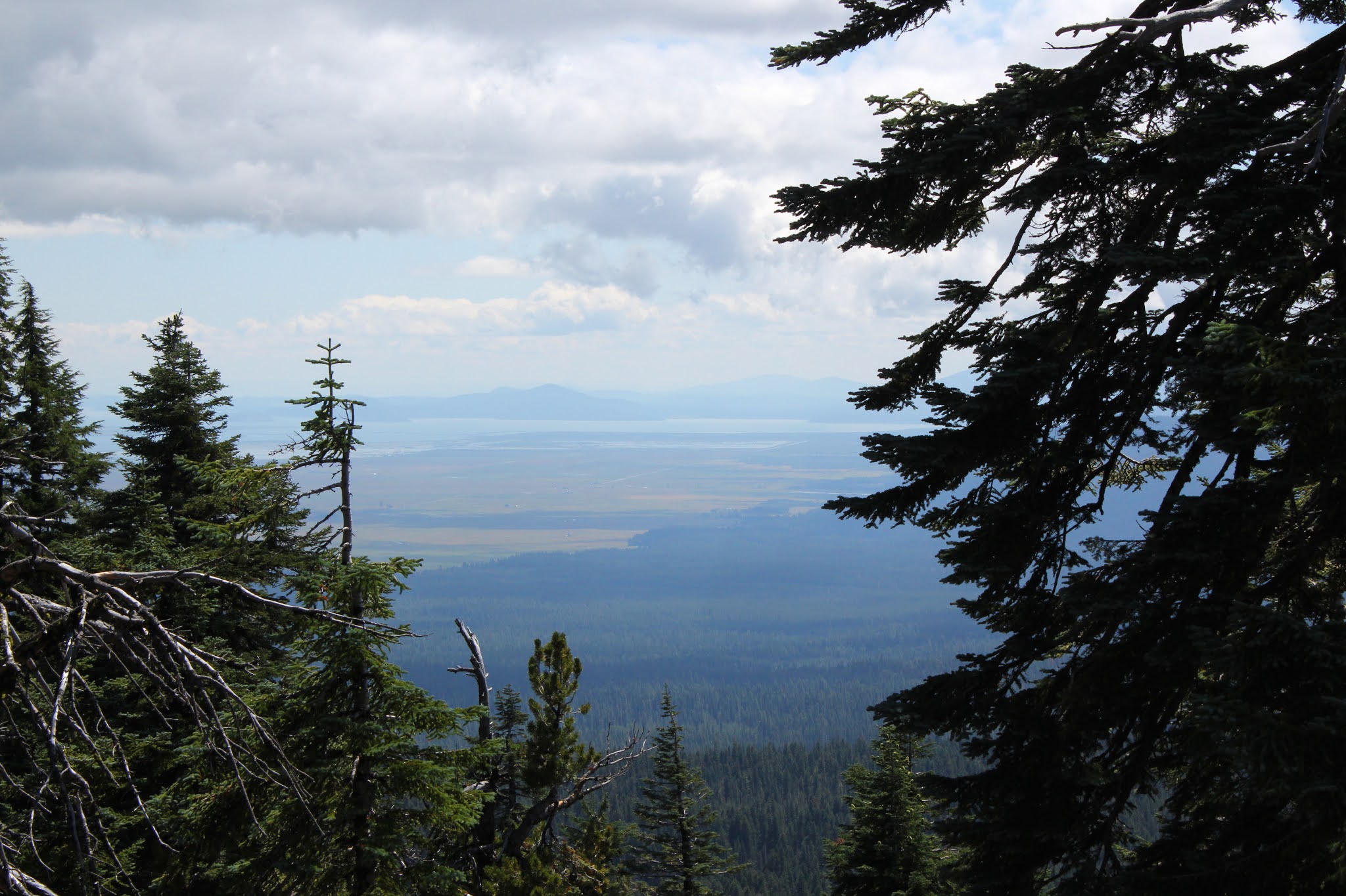
What a view!

The views became more and more astounding as the trail gained elevation, thanks in part to the B&B Fire clearing out the view-blocking forest. Directly south of the trail was the pointy spire of rugged Mount Washington with the Three Sisters looming further beyond. Periodically, Three-Fingered Jack waved hello with one of its non-middle fingers showing above the ridge crest directly in front. To the east was the symmetrical cone of Black Butte with the vast central Oregon outback stretching out into the summer haze. The surrounding geology and geography were spread out like a large-scale three-dimensional atlas diorama, all covered with a fuzzy white layer of ghostly white snags, left courtesy of the B&B Fire.

Some of those surrounding lakes and scenery

There were plenty of lakes scattered in all the topology cited above and to the east, lakes Booth, Martin, and Square reposed in the basin sprawling west of Black Butte. There is supposed to be a cross-country way to leave the PCT and hike down to Martin Lake and return by way of the Square Lake Trail but the jump-off point was not obvious, so I stayed on the PCT like a good boy.

A rare section of green forest

At about the four-mile mark, the trail left the burn zone for a real honest-to-goodness green forest. Good thing too, for the chill breeze had long since failed to be and the day was getting to be quite warm out in the exposed and treeless fire zone. I ate lunch at a rocky viewpoint overlooking an expansive vista of Maxwell Butte and surrounding terrain extending into the McKenzie River drainage.

View to the Mount Washington and the Three Sisters 

After lunch, it was back the way I had come but the major difference was that I was walking downhill (and there was much rejoicing) instead of slogging up to some higher unseen place in my life. Also, instead of staring at the grassy parklike slopes inclining upward in front of me, I very much enjoyed a wide and expansive five-mile view of Mount Washington, the Three Sisters, and an entire county of dead trees under a blue sky. Simply beautiful, and the entire day confirmed my feelings about hiking in an old burn zone.

Path through spent beargrass and dead trees

For more photos of this hike, please visit the Flickr album.

Friday, August 16, 2019

North Umpqua Trail - Calf Segment


When the alluring siren song of higher elevations call in summer, you’re not likely to find me on the North Umpqua Trail (hereafter referred to as the NUT). There's nothing wrong with NUT's 78 miles of consistent beauty but familiarity breeds contempt so they say, and perhaps that’s why I end up on other trails during the summer. However, when the weather turns wet and cold, it's time to set scruples and high-minded snobbery aside, and let the poor orphaned NUT once again become a favored cool weather go-to trail. Despite my snooty attitude about hiking the NUT in summer, I uncharacteristically found myself on the Calf Segment of the NUT on a late summer day just because and for no other discernible reason.

Autumn cometh!

Autumn was politely rapping on summer’s door with eviction notice in hand, but not so fast with the due process of law there, we're in still in the grace period! There were still plenty of plants around that were not anywhere near finished with summer. For example, water hemlock was still flowering as if it was spring, although the plant also did sport seed heads all knotted up like macramé done by a man with two left hands. Fireweed had already gone to seed though, their fluffy cottony seeds floating on just the slightest breeze provocation. The surrounding vegetation was mostly green but there were some red and yellow colored hints that the coming fall season was just around the corner, mostly in the form of big-leaf maple, vine maple, and poison oak leaves.

Fireweed seeds, ready to sail away on the slightest air current

The weather was pure summer, though. The sun was bright, the sky cloudless, and the temperature bordering on out-and-out hot. All that heat shining down upon a flowing river at the bottom of a canyon, not to mention all that forest and rampant greenery on either side of the river, turned the trail into veritable sauna. It didn’t take long for me to become a wet and drippy mess of sweaty goo as I hiked along the trail.

The deep and shallow end of the North Umpqua River

Silt occludes the river in winter and spring, imbuing the river with a stunning turquoise color. At summer’s arrival however, the river flows clear and the color tends toward a deep and vibrant aquamarine. Because of the clarity, I could clearly (pun intended!) see a deep chute carrying the bulk of the river’s current while a foot-deep covering of water ran over a rocky shallow. Uneasy lies the head that wears a kayaker's helmet but on the plus side, you can certainly see what sunk your kayak.

There were still plenty of scars from the 2002 Apple Fire.

In 2002, the Apple Fire destroyed a lot of the forest that used to occupy the Calf Segment. Nearly twenty years later, the forest is well on its way to recovery but there is a noticeable dearth of shade in the middle of the four-mile Calf Segment. On a positive note, the lack of trees facilitated some nice views of the river flowing on the bottom of its canyon and of the surrounding mountains, some covered with forests and some covered with snags, depending on whether fire had visited that slope or not.

Welcome to Boulderville

In some distant epoch that occurred long before my little visit here, large boulders had rolled down to the bottom of the canyon from some unseen cliff hidden in the forests above. And I do mean large, some of these boulders were as big as a scion’s manor. It must have been a huge noise when the boulders tumbled down from above and I hope to never have to witness such an event unless it’s from a safe distance away. At any rate, many of these boulders are now permanently bathing in the blue-green waters of the North Umpqua River, snagging logs floating down the river during the spring flow. And here's a bit of random babble: In a hip, slangy way it’s kind of cool to refer to the North Umpqua Trail as the NUT but nobody refers to the North Umpqua River as the NUR, which would just sound kind of dumb. Moving on, now.

Vine maple trees provided green shade

The Calf runs end-to-end from Panther Creek to Calf Creek and sideswipes Horseshoe Bend in the process. The trailhead at Calf Creek is the logical turnaround point and a trail sign says the Panther Creek Trailhead is 4.75 miles away. Yet, the sign at Panther Creek says Calf Creek is 4.5 miles away. I have noted this before but there you have empirical proof that the trail is always longer when heading back to where you started from.

A rough-and-tumble section of river

Whatever the mileage, it was back from whence I came and my pace was much more relaxed (or slower, some would say) not just because it was pretty darn hot but also because the sun was now shining directly on the North Umpqua, illuminating and enhancing the clarity and color of the pristine water. The trail goes up and down along the river and there was no shortage of viewpoints from which to stop and snap some photographs and/or wipe the sweat off my brow.

Need another forest fire (not!) to create a view of Horseshoe Bend

The heat was the only downer on the day but on the main, this hike was simply gorgeous, serving up a crystal clear river flowing in a canyon, and ample vegetation and forest growing along the trail in the places that were untouched by fire. I really should make it a point to pencil in a summer NUT hike more often, just not on such a warm day.

Water hemlock seed head, all tied up in knots

For more pictures of this hike, please visit the Flickr album.

Sunday, August 11, 2019

Crater Peak


This hike was done on August 11, 2019 and it seems like a whole other lifetime ago. So much change, chaos, and strife has come to torment us all, pretty much like a mosquito swarm devouring a hiker upon the trail, and just about as welcome too. Because I took a year-long writing hiatus in 2019, there is a pile of 2019 hikes sitting on my desk, each patiently waiting to have their story lovingly told. My catch-up plan for the backlog has been to salt the old hikes in here and there in between the 2020 hikes, which are mostly current. As I write about this particular hike in Crater Lake National Park, the date is September 16, 2020 and the entire planet is aflame, or so it seems.  

An early morning rain left the forest damp

I've been regularly hiking for more than two decades, ever since I moved to Oregon. Firsthand, I've seen and experienced changes directly attributable to climate change, everything from retreating glaciers to forests stressed by a burgeoning population of lodgepole beetles. Each year, the snow seasons become shorter and the snow depth shallower. Because of the decrease in snow amounts, the forests dry out by summer and increasingly, I've had to schedule backpack trips and campouts around what is becoming a seasonal near-certainty: apocalyptic wildfires late August or September. 

Cloud, sky, sun, and tree sums up the weather for the day

The year 2020 has been a figurative donkey kick in the nuts for me, both on a personal and collective level. The year started with my daughter Aislinn unexpectedly passing away and has continued with a close relative becoming ill with cancer. Not to mention, this awful Covid-19 pandemic raging against a dreadful backdrop of election noise and cacophony, and now we are being assaulted by massive and abundant wildfires consuming millions of acres of forest and dumping an oppressive layer of smoke on pretty much the entire western United States. Hiking is my refuge from all this and now I'm stuck at home coughing because all the forests are closed and/or on fire, the air is too dangerous to hike in, and who knows when the trails caught up in the fire zones (like the North Umpqua Trail) will be cleaned up and open for hiking again. Sigh, let's go back to happier times, like August 11, 2019, shall we? 

The trail climbed up to rocky Tututni Pass

Crater Lake is the crown jewel in its namesake national park. Each year, hundreds of thousands of visitors the world over come to visit, beginning in July. From personal experience, it is possible to hear the phrase "effin' mosquitoes!" uttered in at least 4,000 languages, only they don't really say "effin'", that's just my way of sanitizing the actual invective. However, there are some backcountry quiet places in the park that do not receive as much adulation from other than the hiking and backpacking crowd.

Shade is never overrated on a warm day

In the park, everybody hikes to the top of Mount Scott, Garfield Peak, and The Watchman to ooh and aah at the splendor that is Crater Lake. However, a small volcanic subsidiary of Mount Mazama (the mountain that created Crater Lake) resides directly south of Garfield Peak and you guessed it, that small cone is Crater Peak, the topic of today’s blog post.

Little Sun Creek created a massive canyon

Beginning near Vidae Falls, a picturesque cascade on Crater Lake’s rim, the trail quickly entered a dry forest and angled to the top of Vidae Ridge. Because of the soft volcanic soil, any moving water like say, a creek, tends to cut a deep canyon and Sun Creek was no exception to that rule as flanking ridges Vidae and Greyback escorted the small creek with a large canyon off of the national park property. Since the trail contoured around the headwaters of Sun Creek, a nice view was had of the massive canyon dutifully executing its assigned task of delivering the creek into the Wood River. 

A pinesap gets ready to start its day

The trail spent most of its time in the forest so there wasn’t a lot to see in particular, other than tall trees. Pinesap, looking all the world like a yellow fungus, was sprouting forth from the forest floor and a Great Crater Peak Reef of coral fungus was likewise emerging from the duff. One other observation was that the trail was really steep, something I had forgotten about. On the way back, I ran into another hiker and his first words to me were “Man, this is a steep trail!” 

A trail perambulates around the crater's meadowed rim

After several miles of grumbling to myself about the steep grade, the trail exited the forest and entered the large green meadow that is the summit of Crater Peak. Apparently, if you hike here in late spring, the wildflower blooms are spectacular. However, on this day the blooms were so last season, so the main focus for me were the views. 

Agency Lake glimmers in the distance

Peaks and valleys abounded and to the north, Mount Scott, Applegate Peak, and Dutton Cliff were most prominent, all sited on Crater Lake’s Rim. To the east sprawled the broad valley of Klamath Marsh underneath a sky full of puffy white clouds. To the south were Agency Lake and Union Peak. Trees were growing on the rim of Crater Peak so you couldn’t quite take in a full 360-degree panorama but a walk around the rim visually delivered the landmarks enumerated above. After a nice lollygag and lunch in the shade of a conifer, I packed up and headed back the way I came, and that was it for the hike.

Coral fungus emerges from its long nap

Sorry about making the hike description so terse but that’s what happens when you take up space ranting about everything 2020 has given us to rant about. At the time of this writing, Crater Lake National Park has been spared from the nearby Thielsen Fire but that could easily change. 
Let’s all hope the coming year will be better. 

Nature's recycler works on decomposing a fallen tree

For more photos of this hike, please visit the Flickr album.