Showing posts with label north umpqua trail. Show all posts

Friday, September 30, 2022

North Umpqua Trail (Swiftwater Segment)


The lower half of the North Umpqua Trail (NUT) used to be so beautiful. A jungle of lush vegetation thrived everywhere and deep shade kept the trail cool even in the warmest of summer days. But in the summer of 2020 the catastrophic Archie Creek Fire went on a fiery rampage and voila, nearly half of the NUT's 78 miles disappeared under landslides, fallen trees, and vigorous regrowth, all inevitable consequences of a large forest fire. In a small sign of progress however, a three-mile segment of trail between Susan Creek and Bob Creek has been restored and that's the subject of today's blog missive.

This part of Susan Creek escaped Archie's wrath

Despite Archie's best efforts to completely blacken the world, the Emerald Trail leading from Susan Creek Day Use Area to Tioga Bridge was still aptly named. The evergreen trees displayed their green foliage per usual, fern fronds draped over the trail, and green moss covered all that did not move. It was a poignant walk through forest totally untouched by fire, especially in view of the ashy devastation waiting for me across the river.

Fire damage and debris were evident
all along the North Umpqua Trail

Massive Tioga Bridge, still bearing Archie's scorch marks tattooed on the stout timbers, crossed the scenic North Umpqua River and "nice" work you've done here, Archie. The former rampant greenery has been supplanted by stand after stand of burned trees (rampant blackery?). Very few live trees exist here on the south side of the river, where the route followed the river from up on high and through all the charred tree trunks you could ever want to look at.

It must have wooly bear season, they were
in profuse abundance on the trail

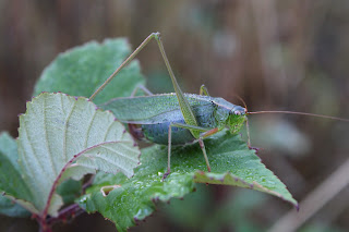
The NUT here is an old roadbed but because of the fire and increased sunlight, grass has taken over the trail, basically converting the roadbed into a narrow singletrack path. As I hiked on the grassy trail, small clouds of panicked grasshoppers fled in front of me. The trail tread was covered with wooly bears (a fuzzy caterpillar, not a real bear with teeth and claws and everything) and I had to watch my step to avoid squishing them. As far as I know, no wooly bears were harmed in the hiking of my hike, or at least no greenish-yellow caterpillar guts were found on a post-hike inspection of my boots.

Falling trees will keep trail crews busy
for at least the next decade

An appreciative round of applause should be directed to our friends at the BLM, for despite the amount of downfall everywhere, the trail had been totally cleared of debris. Sporting fresh cuts in mute testimony to the handiwork of the trail crews, there were several piles of fallen trees heaped next to the trail. It's no easy task keeping trails open after a large fire and the dead trees will continue to fall and create more hard work in the years to come.
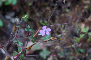
Stinky Bob is a lot prettier
than its name would suggest

If you hike this trail in spring, seasonal creeks and cascades flow across or along the trail. However, hike it in late summer like I was doing, then the creeks had long since gone dry and the nominally green grass and other assorted vegetation were also heading toward that dried-out state of being. However, a small pink geranium known as Stinky Bob was still flowering away in brazen defiance of the coming autumn and winter. Poor Bob, whoever he may have been, his aroma must have been especially notable in view of the fact he has a flower named after him for all of perpetuity.

A grasshopper basks in the early autumn sun

And speaking of autumn, much vegetative elements growing on the dead forest's floor were trending in that direction. Blackberry vines and alder, maple, and dogwood trees were beginning to participate in the autumn beauty pageant by blushing red, orange, yellow, or some hue in between. Most of the leaves were still green but a more colorful hike can be had by hiking here again in a couple of weeks.
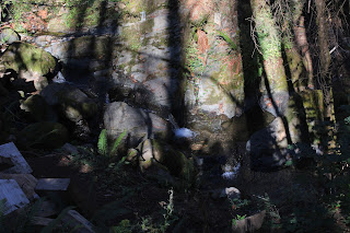
Shadow Man sends greetings from Bob Creek

All that remains of the stout footbridge spanning Bob Creek is a pile of chopped wooden blocks, left over from when the fire-damaged bridge had been dismantled by the authorities. Bob Creek may have been a mere trickle but its defile was a difficult, but not impossible, obstacle to overcome. However, the reward for doing so would be hiking on an unmaintained trail through fire wreckage that is probably officially off limits anyway. I really don't need to pay a fine for hiking on a closed trail, either.
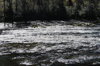
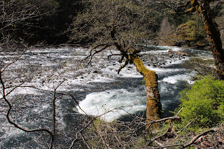
The North Umpqua River sparkles in the sun

So, it was back the way I came, all the way back to the picnic area at Susan Creek. The hike had been an easy 5 miles, so I added a walk to Susan Creek Campground and back for a more worthy distance. The trail to the campground was mostly lush and green, although the woods by the campground had also been burned. In the open sunlight, scarlet poison oak leaves advertised the presence of that accursed plant. Below the path, the North Umpqua River sparkled in the afternoon sun and I couldn't escape noticing thousands of acres of dead trees on the other side of the river, extending all the way up into the surrounding mountains.

Ferns from the Shadow Realm

I've often said there is beauty in a burn zone and I'm really trying hard to love this section of the North Umpqua Trail all over again. But damn, it used to be so beautiful before Archie's sacking and pillage of the once and former live forest. I'll keep working on my attitude, though.

Katydid did it

For more photos of this hike, please visit the Flickr album

Wednesday, July 6, 2022

North Umpqua Trail (Deer Leap Segment)


At Medicine Creek and about three years ago, a huge boulder went on a gravity-induced rampage through the forest along the North Umpqua River. Trees stood no chance against the humongous rock and one tree in particular, was leveraged into karate-chopping the stout hikers' footbridge on the North Umpqua Trail into two large sections of kindling. Somewhat surprising after several years though, the bridge still remains unrepaired and unusable for hiking. To continue on the North Umpqua Trail's Deer Leap Segment from the Soda Springs Trailhead, hikers are forced to bushwhack down to the creek and then either wade or rock-hop across.

Bridge with a back problem

Friend Missy and I set out on the North Umpqua Trail on an overcast morning and within a third of a mile, we ran into the aforementioned crime scene at Medicine Creek. A large destroyed footbridge is truly an awesome sight to behold and we gawked for a bit before actually doing the tedious work of scrambling down to the creek, and then wading (me) or rock-hopping (Missy) across. From there it was a short but steep scramble (both of us) up to the North Umpqua Trail, where in essence, the real hike commenced.

Some of that morning rain on the local vegetation

It had been raining for days prior to this hike but the rain had stopped and apparently this was the day for the storm to dissipate into happy blue sky oblivion. We couldn't fully celebrate being dry, however, as the burgeoning spring vegetation was only too happy to transfer idling water drops stored on leaves and flowers onto the clothing of passing hikers.

Slide Creek slides on by

We passed several creeks crossing the trail but only Slide Creek was deemed worthy of a name. We decamped from the fully intact hiker's bridge there and attempted to get closer to the stream tumbling though its rocky defile. Missy got on a mossy boulder that was canted at an incline towards the creek and the moss let loose and she had a scary glissade that stopped just short of sending her into what surely would have been a painful freefall into the creek and surrounding rocks. Maybe that's why it's called Slide Creek!

Remnant of an ancient landslide

No, Slide Creek did not get its name from Missy nearly sliding into the creek. As we hiked away from the creek, we passed by the obvious remnants of an ancient rockslide that gave Slide Creek its name, the slide now covered with a thick layer of moss. Besides the rockslide, other geologic formations loomed between the intervening trees in the lush forest, as rocky cliffs, spires, and ramparts all stood at attention in permanent testimony to the volcanic origins of the North Umpqua River terrain.

There was plenty of uphill hiking 

The hike gained nearly two thousand feet of elevation over the course of three-plus miles, testing our mettle somewhat but I'm glad to report we were both up to the challenge. By now, the sun was making a concerted effort to warm the day and the combination of wet plant life and hiking exertion turned this hike into a rather humid, sweaty, and smelly affair. And the same goes for me, too!

Candystick emerges 

The season was spring, and to go along with the rampant greenery was rampant flowering with a multitude of colors on display. The rhododendron bushes were still festooned with large pink blossoms but clearly their blooming glory was on the wane. I pointed out to Missy the white and pink flowers of prince's pine and she suggested that become my trail name. White hyacinth, yellow tarweed, and brown wild ginger flowers all represented their respective slices of the color spectrum and we also spotted the striking red and white canes of candystick emerging onto the forest floor from some subterranean sugar shop in the dark earth beneath. 

Nice view, but don't get too close to the edge

The downhill side of the trail dropped away rather abruptly, making for a dizzying overlook of the North Umpqua River coursing over a thousand feet below. I always thought deer with broken hearts leaping to their deaths to squelch their sorrow was how the Deer Leap Segment got its name, but that's just me, because everybody knows deer are heartless creatures. At any rate, we enjoyed the view of the river, canyon, and mountains a safe distance away from the sheer edge of the rim.

The sun came out as we descended to the trailhead

After about four miles of going uphill, the trail finally crested and began to head downhill. Pleased to be hiking downhill but unwilling to surrender our hard-earned elevation gain only to have to regain it on the way back, we called it good and ate lunch at a level spot among some manzanita bushes. On the return leg, it was the same old sublime forest scenery all over again, but happily it was a pleasant downhill walk this time.

Missy picks her way down to Medicine Creek

After crossing over Slide Creek, where we both avoided any near-falls this time, we returned to the wreckage of the Medicine Creek Bridge. From there it was a sketchy drop down to the creek, and from there it was another simple wade (me) across Medicine Creek or a complicated and arduous rock-hop (Missy) that had her wishing she could just do a Deer Leap across. Maybe that's how Deer Leap got its name.

Lava formations were a common sight next to the trail

For more photos of this hike, please visit the Flickr album.

Sunday, April 3, 2022

North Umpqua Trail (Jessie Wright Segment)


"Water heal my body, water heal my soul.
When I go down to the water, by the water I feel whole"

The River
by Coco Love Alcorn

On the way home from this hike, I switched on the radio and the first thing I heard were the above lyrics. Serendipity, the words perfectly summed up my relationship with the North Umpqua River and its namesake trail. The North Umpqua River is always near the North Umpqua Trail and the constant soothing sound of water moving past the forested slopes is like a metaphysical back rub to the soul, although I am nowhere near as eloquent as Coco Love Alcorn, a statement readily confirmed by a random reading of any of my blog entries.

Lots of plants!

Roll the tape back to the middle of the week when I got a text from young Coral Rae who requested her grandfather (me!) take her hiking. Well, when that rare and wondrous event happens, the only proper response is to make it happen. Coral wanted to hike where there were "lots of plants" so we decided on the Deer Leap Segment of the North Umpqua Trail.

A herd of fawn lilies graced the mouth of a cave

I had been on the Dear Leap several years ago and at Medicine Creek, a ginormous boulder had crushed the bridge spanning the small creek. I held hope that perhaps the bridge had been replaced but once we arrived at the site, my hopes were as crushed as the bridge, which was still in pieces right under the guilty slab of rock. I was game for bushwhacking across rain-swollen Medicine Creek, but Coral's shoes were not sufficiently waterproof for that endeavor. 

Not a lot of plants!

No biggie, though, we hiked back to the car and improvised by driving to the Jessie Wright Trailhead, where Wright was right, as far as giant boulders rolling onto trail bridges were concerned. I assured Coral Rae we would see lots of plants but she had her doubts at the start, for the forest was scorched, charred, and mostly dead. Fire is a frequent visitor here and the Jack Fire had hung out here last summer, leaving the trees worse off for the fiery visit.

This trillium patrolled by guard spider

But, as I've stated before, life still thrives in a burn zone and this blackened forest was no different. The ground was carpeted with trillium plants, all displaying flowers with tri-petaled elegance, except for one double-flowered mutant that sported least three-hundred frizzled petals. Crab spiders lurked within the flowers and I found several of them for Coral to gawk at. However, if you are a flower-visiting insect, death also thrives in a burn zone, meted out by the fangs of hungry crab spiders.

Go see what's inside the cave!

At the intersection with the trail coming in from Illahee Flat, there is a large cave sited at the bottom of a sheer cliff. Impressive, to be sure, but the cave's inky black maw was upstaged by a large patch of fawn lilies blooming right in front, the flowers nodding in unison as if to agree with the wise words that leave my mouth, and I liked that. I sent Coral Rae into the cave to check for bears and am glad to report she did not find any.

Water, heal my soul

As stated, the hike began in a burn zone but within a half-mile of hiking, there was sufficient vegetation and live trees to satisfy Coral Rae's plant-centric criteria for the day's hike. The trail contoured up and down before dropping down to river level at a river viewpoint that is one of my favorite places on the North Umpqua Trail. The river widens out here and fans out over several white-watered stair-steps before disappearing around a scenic bend. 

The weirdest flower ever

A sunlit cliff next to the trail provided an opportunity for Grandpa Richard to point out all the plant life clinging to a moist cliff, while Coral Rae surely rolled her eyes behind my back. The flora-based education of Miss Coral continued when I showed her how to find the brown and hairy flowers of wild ginger, and the tiny cups of birds nest fungi. 

Wild strawberry, in its pre-berry phase

This hike was never intended to be an epic test of manhood (or girlhood), so we turned back here. On the way back, we enjoyed the beautiful scenery all over again and the uphill hiking not as much. Coral was excited to find a wild strawberry flower and stated we had to come back to eat the tiny but very tasty berries. Sounds like a good plan to me and like the request to go hiking, it'll be my job to make that happen.

The always scenic North Umpqua River

Inspired by Coco Love Alcorn, I took a post-hike stab at writing beautiful heartfelt lyrics in homage to the river:

"Water heal my back, water heal my knee.
Drink enough water, then I have to pee."

I think I better stick to my day job, even though I don't have one. Plus, I really can't sing either.

The North Umpqua River, 'nuff said

For more photos of this hike, please visit the Flickr album.

Sunday, March 27, 2022

North Umpqua Trail (Swiftwater Segment)


In 2020, the Archie Creek Fire raged along the North Umpqua River, immolating over 130,000 acres of beautiful forest, not to mention numerous homes and businesses. Also falling victim to the massive wildfire, the lower 30 miles or so of our beloved North Umpqua Trail was rendered impassable for hiking. Even if one is inclined to stealth hike on the officially closed trail, the incessant piles of scorched and fallen trees are an effective deterrent. However, rumor had it that part of the Swiftwater Segment of the North Umpqua Trail had been recently cleared and opened, so I just had to go get a look-see.

Here, the trail was untouched by fire

The fire scars and damage were eminently visible from the Susan Creek day use area, the starting point for today's venture. However, the day use area itself was relatively untouched by fire but just after the Susan Creek crossing, trees proudly bore their scorch marks like so many tribal tats. The fire did not get very far into the picnic area, although it did hop-scotch up into the surrounding slopes after jumping the North Umpqua River.

Snow queen bloomed in purple abundance

From the first step onto the trail, it was eminently obvious that spring was very much happening along the North Umpqua River. The forest floor was carpeted with healthy layers of snow queen, woodland violet, and trillium flowers. Also playing their part and vying for the Miss Supporting Wildflower sash were oxalis, bittercress, spring beauty, and candy flower. With all the flowers to photograph, this was not a very fast hike.

Here bee, bee, bee!

There's something insidious about spiders and trilliums. Here, you have an elegant and stately wildflower to entice bees, photographers, and other invertebrates. And yet, cream-colored crab spiders lurk among the pistils and stamens within the flower's interior and on more than one occasion, I have caught the conniving arachnids in flagrante delicto, happily dining on their victim. It just doesn't seem fair, from the bees' perspective, it'd be like a lion ambushing you as you ate a steak at Applebee's. Predictably enough, crab spiders were spotted on the abundance of trillium flowers blooming away on the forest floor and pity the bees.

Tioga Bridge now has battle scars

After a short walk along the North Umpqua River, the trail crossed over the river via photogenic Tioga Bridge. Built on the piers of an old roadway washed out by a 1964 flood, the stout bridge has become a local landmark since its restoration in 2012. The Archie Creek Fire had swept over the river here and while the bridge survived, scorch marks now adorn the wooden beams and trusses. However, the structural integrity of the bridge remained intact and I hiked across, safe and secure on the stout span.

What this part of the Swiftwater Segment
looks like for most of the three miles

Just after the bridge, there is a T-intersection with the North Umpqua Trail where one can go left on the Tioga Section or right on the Swiftwater Segment. The Tioga was clearly closed although the trail showed obvious signs of having been worked on. The Swiftwater at this end is an old road bed which means it's much wider than a footpath and presumably easier to clear fallen trees from. Despite some strong inner temptations to hike the Tioga Segment, closure notwithstanding, I made the right turn onto the Swiftwater.

Seasonal creeks kept things fresh

Seasonal creeks soon became a thing, as they flowed in abundance across the trail. Because the forest is now bare and stark, the noise of flowing water clearly carried all along the route. The small gullies that contained water were green and overly mossed while moisture-loving plants, such as spring beauty and candy flower, happily flourished as if there had never been a fire in the first place.

Life abounded on the forest floor

The forest was mostly dead and if not completely dead, then on life support. However, despite the arboreal skeletons standing everywhere, a veritable choir of songbirds were twittering and tweeting among the charred trees. On the ground, grass, moss, and wildflowers thrived, the vivid green vegetation in sharp contrast to the surrounding tree graveyard.

Wreckage at Bob Creek

After a couple of miles, the North Umpqua Trail morphed into a real footpath and descended steadily down to Bob Creek. The trail used to cross Bob Creek on a stout bridge but the fire ruined the bridge, the remnants of which were haphazardly piled up next to the creek. It would be indeed a strenuous and sketchy endeavor to scramble up and down the creek's formidable and bridgeless defile, only for the privilege of bushwhacking on what appeared to be an unmaintained continuation of the scorched North Umpqua Trail. I called it good here, and headed back the way I had come.

A halo of woodland violet

This section of the North Umpqua Trail used to be one of my favorite hikes because of the lush and verdant greenery flanking either side of the trail. Naturally, things are markedly different than before and during my remaining time on this planet, the forest here will never be like it was. However, I still enjoyed this walk and found it quite beautiful in its own ashy way. Forest fires are part of life, although they don't really need to be as destructive as the Archie Creek Fire had been, and life abounded among the bones, carcass, and general air of death of what once was a vibrant forest. It's just a different kind of beauty and despite the carnage, it's still very much a pleasant hike.

If you like charred wood, then this is your hike

For more photos of this hike, please visit the Flickr album. 

Saturday, October 30, 2021

North Umpqua Trail (Hot Springs Segment)


Last year, the Friends of the Umpqua's outing on the North Umpqua Trail's Hot Springs Segment had been all about the autumn colors. It was Halloween weekend and the weather had been gloriously sunny, the sky inspiringly blue, and the forest brilliant with fall colors. I happily hiked as one with the elements, because I too am bright and flamboyantly colorful. However, this year's hike was the exact opposite. Three weeks of rain had knocked most of the leaves out of the trees, the temperature was on bordering on cold, and the overcast sky rudely dumped water on our heads. What a difference a year makes!

Colorless grubs and crawly things

Beginning from the trailhead at Toketee Lake, ten hikers warmed up with a pleasant up and down ramble through a dimly lit forest above the mostly unseen river. This section was all green with ferns, moss, Oregon grape, and a whole forest comprised primarily of Douglas fir. The dark forest seemed to be darker than usual though, thanks to a gloomy gray sky overhead and a general scarcity of sunlight. Underneath the trees, we scuttled in the low light like so many colorless grubs and crawly things slithering away from underneath a freshly overturned garden stone.

The Golden Path

After a bit, the trail dropped down to the North Umpqua River and commenced one of my favorite sections of trail. Here the path follows the river and in autumn, is blanketed with a thick layer of fallen leaves. Just follow the Golden Path, Richard, and you will be rich beyond your wildest dreams, the richness in this case pertaining to the glorious autumn vibe. When not ambling beneath maples and their fading leaves (mostly on the ground), the trail wound its way through a cathedral of tall firs flanking either side of the trail and I gaped in reverential awe like some humble pilgrim finally reaching his sanctified destination.

Trees (and maybe a hiker or two)
get buried by the leaves

As mentioned, the forest floor (and trail) were shag-carpeted with a thick layer of leaves. Already, the processes of decomposition and soil regeneration were well underway. Individual fronds of Oregon grape and ferns had snagged some of the fallen maple leaves which were now decomposing on the evergreen plants and shrubs. The contours of fallen trees of seasons past were barely visible underneath mountains of accumulated leaf litter. Mushrooms and fungi of various ilk and specie were taking advantage of the decaying biomass and just generally thrived all over.

The North Umpqua Trail gently
climbs up to Deer Creek

At just under the two-mile mark, the North Umpqua Trail egressed onto a forest road and the path then resumed on the other side of the river. The only uphill hiking commenced here, but fortunately it wasn't daunting at all, just a steady climb through a lush and tangled forest. Here, the North Umpqua Trail diverged from the North Umpqua River but Deer Creek happily took the river's trailside place and burbled merrily somewhere down there in the forest below. As I hiked through the bucolic scenery, the peace and quiet of the forest was suddenly interrupted by John hiking in my direction with an obvious limp. Uh-oh.

Final score: This little creek 1, Knees 0

Up ahead there is an unnamed creek that was just a trickle last year. This year, it was running vigorously and enterprising hikers had fashioned a primitive creek crossing made up of branches and rocks. One of these rocks broke in two when John stepped on it, causing him to have an unwanted sit-down in the creek. Also unwanted, was a knee bending the wrong way and John had to take his sprained joint back to the trailhead, one gimpy step at a time.

Deer Creek flows under the hiker's bridge

After making sure John was in reasonable enough shape to hike back without assistance, I continued on to Deer Creek, my turnaround point. Everybody else had continued on to Columnar Falls but because I had lagged behind, this hike had turned out to be more photo shoot than hike so Deer Creek was as far as I would get. At the stout metal and wood bridge spanning the stream, I took a moment or two just to simply appreciate the beauty of the creek approaching from upstream, well on its way to joining forces with the North Umpqua River. 

Natural leaf arrangement on a log

Shortly after turning around and heading back, the ominous gray clouds delivered on their threat to rain on us. The day darkened considerably and the pitter-patter of raindrops and the surround-sound hiss of millions of raindrops striking millions of fallen leaves were a soothing counterpoint to the rhythmic noise of my boots swishing through the leaf litter cloaking the path. Since I was now ahead of everybody else, I took my appreciative and thankful time as I walked, while valiantly trying my best to keep the camera dry.

New arrival

It was a short wait at the trailhead before everybody else began straggling in, all wet and bedraggled like my dogs get when I've forgotten to let them back in the house on a rainy day. The day was now dark and gloomy with that hint of cold that says winter is on its way, and all hikers, including me, were rain-soaked and sodden. Despite the discomfiture caused by the inclement weather, nonetheless I had happily hiked as one with the elements, for I too am gloomy, gray, and chill.

A family of mushrooms make
a happy home on a rotting log

For more photos of this hike, please visit the Flickr album.