Showing posts with label North Umpqua River. Show all posts

Wednesday, August 10, 2022

Fall Creek Falls and Susan Creek Falls


At the trailhead and right next to our vehicle, somebody had spray-painted an outline of a human figure on the asphalt, like something right out of a homicide investigation. Somehow that was apt, for we had most definitely hiked in a mass casualty scene. You see, in 2020 the Archie Creek Fire had swept through this area, leaving behind charred carcasses of what once had been live trees. Because of the extensive fire damage, the Fall Creek Falls Trail had been closed for over a year, but on an overcast weekday morn, Rheo, Dianne, Jane, and I went out for a an investigative look-see at the newly reopened trail to the falls.

Fall Creek is a little worse for the wear
Prior to the fire, the walk to the falls had been the quintessential green hike. Back then, Fall Creek burbled next to the trail, nearby boulders were heavily mossed, and ferns ruled the creek banks. What a difference a catastrophic forest fire can make, for now the boulders were moss-free and bore the scorch marks of the rampaging conflagration. Tall and very dead trees flanked the trail, and debris choked Fall Creek.

Queen Anne's lace 
However, not all was lost, for beneath the many acres of dead trees, thrived a healthy population of sun-loving plants and late-season bloomers such as fireweed, pearly everlasting, thistles, and Queen Anne's lace. The vibe is not as green as in years prior, but these new vegetative populations are doing their best to prettify the trail.

Maple beetles are thriving in the burn area
Insect life has returned to the burn zone too, mostly in the form of numerous maple beetles crawling on the trail and on most of the aforementioned plants and flowers. Ladybugs were also spotted huddling together for shelter on the underside of common yarrow flower heads. 

Lower Fall Creek Falls
Because of the lack of foliage, we could actually now observe both upper and lower falls at the same time from a fair distance away. Even though the picturesque cascade was fully visible, it still was much cooler to admire the lower falls from the splash basin and the upper falls from a railed overlook, and we obliged both.

It was a berry nice hike
The hike to the falls is pretty short, which is one reason I haven't hiked there all that much. So, for some extra mileage we explored the forest road at the top of the cascade. The homes that had been here before had also been lost to the fire and the road was clearly sagging, ready to slide downhill at the slightest provocation, like hikers walking on it. The atmosphere up here among all the death and destruction was somewhat on the forlorn side, although the blackberries growing here were delicious.

The "forest" at Susan Creek
Susan Creek was likewise ravaged by Archie but it was conveniently located on the way home, so we stopped there for another short hike to another spectacular waterfall. Just like at Fall Creek, the hike took place among the charred skeletons of trees past. But at least there was no coroner's pictograph on the parking lot pavement.

Pretty to look at but common tansy is not welcome
There were the same type of wildflowers seen at Fall Creek but there were some different ones too. The yellow daisy-like flowers of common tansy were pretty to look at but are most unwelcome, since tansy is a prolific invasive species. Pale blue wild chicory and lavender-tinted aster were more abundant here than they had been at Fall Creek.

Susan Creek Falls
Susan Creek Falls tumbles over its rocky ledge in spectacular fashion, although it's still a bit odd for us old-timers to see the falls in bright daylight instead of in its former mossy and shady basin. Get used to it Richard, it's not going to change much during your remaining time on this planet. We lunched at the picnic area below the falls and enjoyed the scene as we ate our respective fruits, snacks, hot peppers, and gummy worms.

Stink bug gendarmes escort the St. John's wort beetle prisoner
As at Fall Creek, insect life abounded on the surrounding vegetation. Shiny black St. John's wort beetles thrived not on St. John's wort, but on fireweed instead. Stink bugs wandered among the St. John's wort beetles, trundling along like insectile armored tanks warring over the same patch of fireweed. Not willing to engage hostile bug forces in combat over fireweed apparently, maple beetles crawled all over thistle plants and not on maples as their name would suggest. 

Western tailed blue butterfly
Not all of the insects were of the beetle variety as numerous butterflies danced from flower to flower. Of note were some brilliant sulfur-colored butterflies that would not stay still long enough for stealthy photographers. Oh well, I had to settle for a photo of a gray butterfly thingy but the fun was all in the chase.

One small piece of Fall Creek Falls
All of us on this outing are long-time (also known as "old") hikers and are quite familiar with how things used to be along this section of the North Umpqua River. To keep sane, which is a relative term, one just needs to accept the basic fact that things will never be like they were, at least during our lifetime. However, it's not necessarily a bad thing and these two short hikes proved the point that there is still great beauty along the river post-fire, it's just a different kind of beauty than what used to be.

Upper Fall Creek Falls
For more photos of the Fall Creek hike,
please visit this Flickr album.

Not the trail it used to be
For more photos of the Susan Creek hike, please visit this Flickr album.

Saturday, May 14, 2022

North Bank Habitat (Best Hike Ever!)


In what was definitely not truth in advertising, this hike was dubbed the Best Hike Ever. Back on New Year's Day, Brad, our hike leader, had led a North Bank hike  that will forever live in club lore as The Worst Hike Ever because of formidably steep trails. Flash forward a few more months to the present and now we were going to do the same route, but this time in reverse, exchanging the incredibly steep Powerline Road for the incredibly steep East Boundary Road. Because this hike was the opposite of the Worst Hike Ever, it acquired the rather Orwellian title of Best Hike Ever.

Rheo commences the Best Hike Ever

The hike began with an easy amble down the Habitat's entrance road and we gaily skipped along, a song in our hearts, if not on our lips. We made a left turn onto the trail and all happy songs immediately died in mid-trill, supplanted instead by a chorus of horrified shrieks sounding like so many Aztec death whistles. In front of us, looming like a grassy Great Wall of China (but way taller) was the East Boundary Road, seemingly rising straight up to Mars or beyond. Yikes, legs quivered and ached before we even began the dismal trudgery of hiking The Best Freaking Hike Never.

Photo of the trail, taken while I was not resting

About halfway up the first major slog, I think my calves began to cramp up, followed in short order by hamstring pulls, respiratory distress, hives, and maybe dilated pupils. Whew, this was hard work and I did lots of photography because I was NOT resting, no matter how much it may have looked like I might have been. 

Douglas' iris decorated the grassy slopes

But if you are going to flame out on your Last Hike Ever, you might as well do it where it's scenic and this North Bank Medieval Torture Chamber Trail fit the bill. Spring was in full song and the vertical walls (oops, I meant to say "rolling hills") were covered with lush green grass. And if I were tempted to plop down on the ground in total exhaustion, the colorful red and oily leaves of the ever-present poison oak were more than adequate deterrent, the fear of itchy rash being sufficient motivation to remain upright, if not necessarily to keep walking. 

What a changing forget-me-not looks like

The wildflowers were putting on a show, best admired when bent over with hands on knees, lungs heaving mightily. Fiddleneck, wild iris, and Indian pink were all abloom, just to name several species from a cast of thousands. During one of my photo-ops while NOT resting, I spotted an odd little flower resembling a fiddleneck that sported flowers ranging from blue to yellow to white, all on the same flower head. It was a changing forget-me-not (Myosotis discolor), whose flowers start out blue but like my hair, turn white with age. I'd never seen this wildflower before, so that was kind of cool. 

Vista to a neighboring ridge

As we slogged on ever upward, crying for our Mamas all the while, the views began to entertain, expanding in direct proportion to the hard-won elevation we were gaining. Directly below the East Boundary Ridge, lay a quilted picnic blanket of farmlands extending all the way to the small town of Glide. Nearby and in the Habitat, were the wooded crest and grassy mounds of Middle Ridge, and we could peer directly down into the valley of Blacktail Basin, whose trail was a much easier route up to North Boundary Ridge than our current route, Brad.

Yay, the grade is merely uphill!

At about a mile and a half of hiking up a wall with a trail on it, the grade eased and the path morphed into what charitably could be called a "merely uphill" route. The dirt road undulated up and down a series of high points on the ridge and we all rejoiced at the newfound normalcy of the grade.

Fortunately, it never rained on us, despite the threat

At about the four-mile mark, the trail attained North Boundary Ridge which also served up its own daunting up-and-down route on its grassy crest. But if you hiked up the East Boundary Ridge Road to get there, well then it almost seemed like you were hiking downhill as the grade was nowhere near as demanding. On top of North Boundary Ridge, we availed ourselves the opportunity to snack, rest, regroup, and curse all things Brad.

Just when you didn't think the
hike could get any "better"

On the New Year's Day Worst Hike Ever venture, our foe back then had been Powerline Road. However, we'd be hiking down Powerline today and Brad assured us it was all downhill. I reminded him that no, there actually was a pretty good uphill pull to perform before we could say it was all downhill. At least there was no snow this time, although there was mud, wildflowers, and views as we descended. Some of us lay in the mud in protest when we gave up on the aforementioned steep climb on Powerline Road.

Pastoral scene on the steep
descent down Powerline Road

After a leg-braking, knee-taxing, soul-sucking descent down lush grassy slopes, we plopped down in exhaustion at the pavilion area, some of us face first. Brad served us lunch and snacks, if only to prevent us from kicking him in the rear for coming up with this hike. My own opinion is that he should have doled out ibuprofen instead of food to stay in our good graces.

What's a North Bank hike without poison oak?

For more photos of this hike, please visit the Flickr album.

Wednesday, April 6, 2022

North Bank (West Loop)


I went with some friends the other day on a mid-week hike at our frequent hiking haunt, the North Bank Habitat. Our route of choice was the loop which I have always unimaginatively and directionally referred to as the West Loop, but today I heard it cited as the Boot Camp Loop. It sort of fits because the steepness of the trails that wind up and down the various high points on the north ridge will have your wishing for an honorable discharge in no time at all.

Simply a beautiful spring day at the Habitat

It didn't take long for the seven of us to separate into two distinct hiking cadres: me and Penny, and everybody else. Guess which two hikers had cameras? At any rate, the morning was crisp and clear, the hills were bathed in green grass, and the floral end of the gene pool was in full spring symphony, be it in flowers or leaves. So we walked slow and enjoyed the scenery while our comrades marched in double-time up and down the hills at some unseen distance ahead of us. Just so they wouldn't wonder whether or not we had carked it on the trail, we sent a text message advising the speedsters not to wait for us.

Maple trees were in full flower

The first part of the route initially followed a gravel road through ranch pastures where bemused cows placidly chewed cud as we hiked by. A right turn put us on a dirt road accompanying barely trickling Chasm Creek flowing through some peaceful and serene oak woods, the trees still bereft of any leaves. Branches were draped with long strands of lichen that swayed with the slightest air current while birds musically chirped their mating calls in feathered hopes of scoring an avian romp in the woods. Wild iris, shooting stars, henbit, buttercup, and Oregon grape bloomed amok in the green grasses reposing under a vibrant blue sky, making bees and butterflies happy. Life was good and colorful here.

One steep trail in a Habitat full of them

The colorful beauty was soon forgotten though, supplanted instead by the immediate urgency of  burning leg muscles when the trail headed uphill in earnest, seemingly in a hurry to get up to North Boundary Ridge. Didn't anybody ever hear of a switchback?  But, if you are going to struggle on a hike, you should have beautiful things to look at, and we did. As we gained elevation, white baby blue-eyes populated the grassy parts, while flower friends desert parsley and purple sanicle aided and abetted. Penny and I spent more than one occasion crawling through the aforementioned green grass like human sheep, just to photograph the flowers.

The dark leaves of Satan's favorite shrub 

Spring is the optimal season to visit the Habitat in my opinion. As mentioned, the hills were wrapped in a vivid shawl of green grass; that is, if you ignore the dark bloodshot leaves of poison oak. Ignore at your own risk, though, for the plant is quite profuse and is ever ready to award rashes to inattentive hikers. The accursed plant was everywhere, and while I have issues with its itchy malevolence, the new red leaves do impart a splashy, flashy, yet rashy burgundy vibe to the hike. 

Gentle and rolling

As we gained elevation, the trees thinned out and then it was all gentle and rolling green hills dotted with small stands of oak trees. I've often said the gentle rolling hills are only gentle when you don't have to hike up them and that wry observation still holds true. At any rate, the more we climbed, the more we were treated to some amazing views of the peaks and valleys surrounding the North Umpqua River, ever flowing below our North Boundary Ridge aerie in a series of serpentine bends with the water glinting silver in the noonday sunlight. 

Trail on top of the North Bank world

Part of the reason we could see so far was that the weather was perfect. It was never too hot, the sun was out, and the sky was blue and cloudless. The clarity of the air meant that we could see many leagues in every direction, although the air did haze up a bit as the day wore on. As an example, the distant peaks of the Siskiyou Wilderness, located just over 100 miles away in California, were faintly visible to the naked eye on the southwestern horizon.

It's all (not!) downhill from here

Once on North Boundary Ridge, the Boot Camp aspects of the hike were on full display as the trail went up and down, always steep, and never level. The trail summited what felt like 5,532 high points and promontories, the only saving grace being the totally awesome views of the terrain flanking the North Umpqua River. But once we hit Middle Ridge, it was mostly downhill, the irony being there were still several steep uphill pitches on the descent, even though the trail was generally pointed downward. In the North Bank, even the downhill hiking can qualify as a Boot Camp Hike.

Butter cups by the cupful

All good Boot Camp Hikes do come to an end though, and this one ended at a noteworthy field of buttercups at the trailhead. One buttercup does not an awesome sight make, but cram millions of them into a grassy pasture then you then have a visual buttered French Toast ready to be slathered in sticky syrup. The sight of that golden parcel of pasture was more than adequate reward for the Boot Camp trials and tribulations on the day for us two plebes.

An agoseris blooms in the low grass

For more photos of this hike,
please visit the Flickr album.

Sunday, March 27, 2022

North Umpqua Trail (Swiftwater Segment)


In 2020, the Archie Creek Fire raged along the North Umpqua River, immolating over 130,000 acres of beautiful forest, not to mention numerous homes and businesses. Also falling victim to the massive wildfire, the lower 30 miles or so of our beloved North Umpqua Trail was rendered impassable for hiking. Even if one is inclined to stealth hike on the officially closed trail, the incessant piles of scorched and fallen trees are an effective deterrent. However, rumor had it that part of the Swiftwater Segment of the North Umpqua Trail had been recently cleared and opened, so I just had to go get a look-see.

Here, the trail was untouched by fire

The fire scars and damage were eminently visible from the Susan Creek day use area, the starting point for today's venture. However, the day use area itself was relatively untouched by fire but just after the Susan Creek crossing, trees proudly bore their scorch marks like so many tribal tats. The fire did not get very far into the picnic area, although it did hop-scotch up into the surrounding slopes after jumping the North Umpqua River.

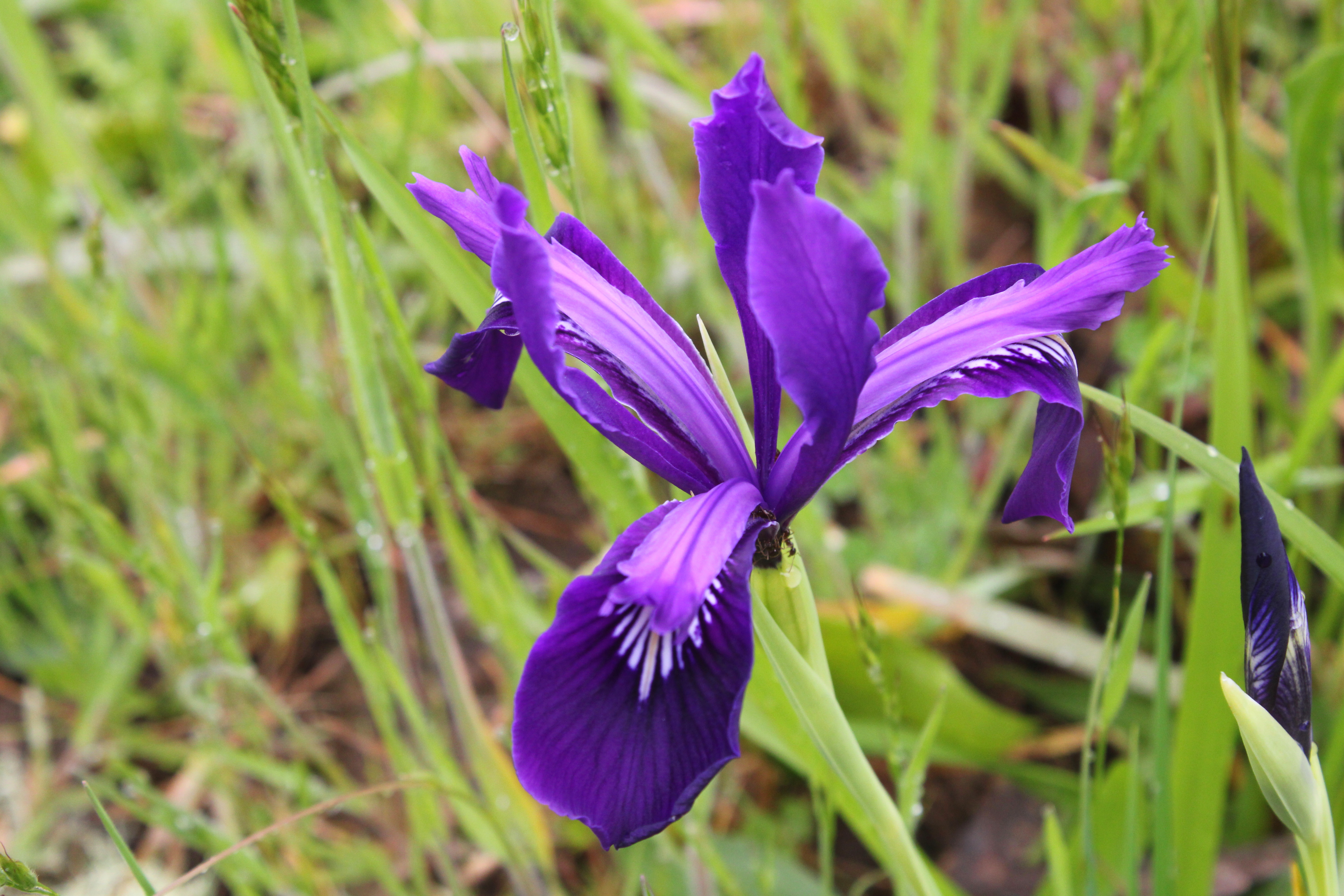
Snow queen bloomed in purple abundance

From the first step onto the trail, it was eminently obvious that spring was very much happening along the North Umpqua River. The forest floor was carpeted with healthy layers of snow queen, woodland violet, and trillium flowers. Also playing their part and vying for the Miss Supporting Wildflower sash were oxalis, bittercress, spring beauty, and candy flower. With all the flowers to photograph, this was not a very fast hike.

Here bee, bee, bee!

There's something insidious about spiders and trilliums. Here, you have an elegant and stately wildflower to entice bees, photographers, and other invertebrates. And yet, cream-colored crab spiders lurk among the pistils and stamens within the flower's interior and on more than one occasion, I have caught the conniving arachnids in flagrante delicto, happily dining on their victim. It just doesn't seem fair, from the bees' perspective, it'd be like a lion ambushing you as you ate a steak at Applebee's. Predictably enough, crab spiders were spotted on the abundance of trillium flowers blooming away on the forest floor and pity the bees.

Tioga Bridge now has battle scars

After a short walk along the North Umpqua River, the trail crossed over the river via photogenic Tioga Bridge. Built on the piers of an old roadway washed out by a 1964 flood, the stout bridge has become a local landmark since its restoration in 2012. The Archie Creek Fire had swept over the river here and while the bridge survived, scorch marks now adorn the wooden beams and trusses. However, the structural integrity of the bridge remained intact and I hiked across, safe and secure on the stout span.

What this part of the Swiftwater Segment
looks like for most of the three miles

Just after the bridge, there is a T-intersection with the North Umpqua Trail where one can go left on the Tioga Section or right on the Swiftwater Segment. The Tioga was clearly closed although the trail showed obvious signs of having been worked on. The Swiftwater at this end is an old road bed which means it's much wider than a footpath and presumably easier to clear fallen trees from. Despite some strong inner temptations to hike the Tioga Segment, closure notwithstanding, I made the right turn onto the Swiftwater.

Seasonal creeks kept things fresh

Seasonal creeks soon became a thing, as they flowed in abundance across the trail. Because the forest is now bare and stark, the noise of flowing water clearly carried all along the route. The small gullies that contained water were green and overly mossed while moisture-loving plants, such as spring beauty and candy flower, happily flourished as if there had never been a fire in the first place.

Life abounded on the forest floor

The forest was mostly dead and if not completely dead, then on life support. However, despite the arboreal skeletons standing everywhere, a veritable choir of songbirds were twittering and tweeting among the charred trees. On the ground, grass, moss, and wildflowers thrived, the vivid green vegetation in sharp contrast to the surrounding tree graveyard.

Wreckage at Bob Creek

After a couple of miles, the North Umpqua Trail morphed into a real footpath and descended steadily down to Bob Creek. The trail used to cross Bob Creek on a stout bridge but the fire ruined the bridge, the remnants of which were haphazardly piled up next to the creek. It would be indeed a strenuous and sketchy endeavor to scramble up and down the creek's formidable and bridgeless defile, only for the privilege of bushwhacking on what appeared to be an unmaintained continuation of the scorched North Umpqua Trail. I called it good here, and headed back the way I had come.

A halo of woodland violet

This section of the North Umpqua Trail used to be one of my favorite hikes because of the lush and verdant greenery flanking either side of the trail. Naturally, things are markedly different than before and during my remaining time on this planet, the forest here will never be like it was. However, I still enjoyed this walk and found it quite beautiful in its own ashy way. Forest fires are part of life, although they don't really need to be as destructive as the Archie Creek Fire had been, and life abounded among the bones, carcass, and general air of death of what once was a vibrant forest. It's just a different kind of beauty and despite the carnage, it's still very much a pleasant hike.

If you like charred wood, then this is your hike

For more photos of this hike, please visit the Flickr album.