Showing posts with label douglas county. Show all posts

Friday, September 30, 2022

North Umpqua Trail (Swiftwater Segment)


The lower half of the North Umpqua Trail (NUT) used to be so beautiful. A jungle of lush vegetation thrived everywhere and deep shade kept the trail cool even in the warmest of summer days. But in the summer of 2020 the catastrophic Archie Creek Fire went on a fiery rampage and voila, nearly half of the NUT's 78 miles disappeared under landslides, fallen trees, and vigorous regrowth, all inevitable consequences of a large forest fire. In a small sign of progress however, a three-mile segment of trail between Susan Creek and Bob Creek has been restored and that's the subject of today's blog missive.

This part of Susan Creek escaped Archie's wrath

Despite Archie's best efforts to completely blacken the world, the Emerald Trail leading from Susan Creek Day Use Area to Tioga Bridge was still aptly named. The evergreen trees displayed their green foliage per usual, fern fronds draped over the trail, and green moss covered all that did not move. It was a poignant walk through forest totally untouched by fire, especially in view of the ashy devastation waiting for me across the river.

Fire damage and debris were evident
all along the North Umpqua Trail

Massive Tioga Bridge, still bearing Archie's scorch marks tattooed on the stout timbers, crossed the scenic North Umpqua River and "nice" work you've done here, Archie. The former rampant greenery has been supplanted by stand after stand of burned trees (rampant blackery?). Very few live trees exist here on the south side of the river, where the route followed the river from up on high and through all the charred tree trunks you could ever want to look at.

It must have wooly bear season, they were
in profuse abundance on the trail

The NUT here is an old roadbed but because of the fire and increased sunlight, grass has taken over the trail, basically converting the roadbed into a narrow singletrack path. As I hiked on the grassy trail, small clouds of panicked grasshoppers fled in front of me. The trail tread was covered with wooly bears (a fuzzy caterpillar, not a real bear with teeth and claws and everything) and I had to watch my step to avoid squishing them. As far as I know, no wooly bears were harmed in the hiking of my hike, or at least no greenish-yellow caterpillar guts were found on a post-hike inspection of my boots.

Falling trees will keep trail crews busy
for at least the next decade

An appreciative round of applause should be directed to our friends at the BLM, for despite the amount of downfall everywhere, the trail had been totally cleared of debris. Sporting fresh cuts in mute testimony to the handiwork of the trail crews, there were several piles of fallen trees heaped next to the trail. It's no easy task keeping trails open after a large fire and the dead trees will continue to fall and create more hard work in the years to come.

Stinky Bob is a lot prettier
than its name would suggest

If you hike this trail in spring, seasonal creeks and cascades flow across or along the trail. However, hike it in late summer like I was doing, then the creeks had long since gone dry and the nominally green grass and other assorted vegetation were also heading toward that dried-out state of being. However, a small pink geranium known as Stinky Bob was still flowering away in brazen defiance of the coming autumn and winter. Poor Bob, whoever he may have been, his aroma must have been especially notable in view of the fact he has a flower named after him for all of perpetuity.

A grasshopper basks in the early autumn sun

And speaking of autumn, much vegetative elements growing on the dead forest's floor were trending in that direction. Blackberry vines and alder, maple, and dogwood trees were beginning to participate in the autumn beauty pageant by blushing red, orange, yellow, or some hue in between. Most of the leaves were still green but a more colorful hike can be had by hiking here again in a couple of weeks.

Shadow Man sends greetings from Bob Creek

All that remains of the stout footbridge spanning Bob Creek is a pile of chopped wooden blocks, left over from when the fire-damaged bridge had been dismantled by the authorities. Bob Creek may have been a mere trickle but its defile was a difficult, but not impossible, obstacle to overcome. However, the reward for doing so would be hiking on an unmaintained trail through fire wreckage that is probably officially off limits anyway. I really don't need to pay a fine for hiking on a closed trail, either.

The North Umpqua River sparkles in the sun

So, it was back the way I came, all the way back to the picnic area at Susan Creek. The hike had been an easy 5 miles, so I added a walk to Susan Creek Campground and back for a more worthy distance. The trail to the campground was mostly lush and green, although the woods by the campground had also been burned. In the open sunlight, scarlet poison oak leaves advertised the presence of that accursed plant. Below the path, the North Umpqua River sparkled in the afternoon sun and I couldn't escape noticing thousands of acres of dead trees on the other side of the river, extending all the way up into the surrounding mountains.

Ferns from the Shadow Realm

I've often said there is beauty in a burn zone and I'm really trying hard to love this section of the North Umpqua Trail all over again. But damn, it used to be so beautiful before Archie's sacking and pillage of the once and former live forest. I'll keep working on my attitude, though.

Katydid did it

For more photos of this hike, please visit the Flickr album. 

Wednesday, August 10, 2022

Fall Creek Falls and Susan Creek Falls


At the trailhead and right next to our vehicle, somebody had spray-painted an outline of a human figure on the asphalt, like something right out of a homicide investigation. Somehow that was apt, for we had most definitely hiked in a mass casualty scene. You see, in 2020 the Archie Creek Fire had swept through this area, leaving behind charred carcasses of what once had been live trees. Because of the extensive fire damage, the Fall Creek Falls Trail had been closed for over a year, but on an overcast weekday morn, Rheo, Dianne, Jane, and I went out for a an investigative look-see at the newly reopened trail to the falls.

Fall Creek is a little worse for the wear
Prior to the fire, the walk to the falls had been the quintessential green hike. Back then, Fall Creek burbled next to the trail, nearby boulders were heavily mossed, and ferns ruled the creek banks. What a difference a catastrophic forest fire can make, for now the boulders were moss-free and bore the scorch marks of the rampaging conflagration. Tall and very dead trees flanked the trail, and debris choked Fall Creek.

Queen Anne's lace 
However, not all was lost, for beneath the many acres of dead trees, thrived a healthy population of sun-loving plants and late-season bloomers such as fireweed, pearly everlasting, thistles, and Queen Anne's lace. The vibe is not as green as in years prior, but these new vegetative populations are doing their best to prettify the trail.

Maple beetles are thriving in the burn area
Insect life has returned to the burn zone too, mostly in the form of numerous maple beetles crawling on the trail and on most of the aforementioned plants and flowers. Ladybugs were also spotted huddling together for shelter on the underside of common yarrow flower heads. 

Lower Fall Creek Falls
Because of the lack of foliage, we could actually now observe both upper and lower falls at the same time from a fair distance away. Even though the picturesque cascade was fully visible, it still was much cooler to admire the lower falls from the splash basin and the upper falls from a railed overlook, and we obliged both.

It was a berry nice hike
The hike to the falls is pretty short, which is one reason I haven't hiked there all that much. So, for some extra mileage we explored the forest road at the top of the cascade. The homes that had been here before had also been lost to the fire and the road was clearly sagging, ready to slide downhill at the slightest provocation, like hikers walking on it. The atmosphere up here among all the death and destruction was somewhat on the forlorn side, although the blackberries growing here were delicious.

The "forest" at Susan Creek
Susan Creek was likewise ravaged by Archie but it was conveniently located on the way home, so we stopped there for another short hike to another spectacular waterfall. Just like at Fall Creek, the hike took place among the charred skeletons of trees past. But at least there was no coroner's pictograph on the parking lot pavement.

Pretty to look at but common tansy is not welcome
There were the same type of wildflowers seen at Fall Creek but there were some different ones too. The yellow daisy-like flowers of common tansy were pretty to look at but are most unwelcome, since tansy is a prolific invasive species. Pale blue wild chicory and lavender-tinted aster were more abundant here than they had been at Fall Creek.

Susan Creek Falls
Susan Creek Falls tumbles over its rocky ledge in spectacular fashion, although it's still a bit odd for us old-timers to see the falls in bright daylight instead of in its former mossy and shady basin. Get used to it Richard, it's not going to change much during your remaining time on this planet. We lunched at the picnic area below the falls and enjoyed the scene as we ate our respective fruits, snacks, hot peppers, and gummy worms.

Stink bug gendarmes escort the St. John's wort beetle prisoner
As at Fall Creek, insect life abounded on the surrounding vegetation. Shiny black St. John's wort beetles thrived not on St. John's wort, but on fireweed instead. Stink bugs wandered among the St. John's wort beetles, trundling along like insectile armored tanks warring over the same patch of fireweed. Not willing to engage hostile bug forces in combat over fireweed apparently, maple beetles crawled all over thistle plants and not on maples as their name would suggest. 

Western tailed blue butterfly
Not all of the insects were of the beetle variety as numerous butterflies danced from flower to flower. Of note were some brilliant sulfur-colored butterflies that would not stay still long enough for stealthy photographers. Oh well, I had to settle for a photo of a gray butterfly thingy but the fun was all in the chase.

One small piece of Fall Creek Falls
All of us on this outing are long-time (also known as "old") hikers and are quite familiar with how things used to be along this section of the North Umpqua River. To keep sane, which is a relative term, one just needs to accept the basic fact that things will never be like they were, at least during our lifetime. However, it's not necessarily a bad thing and these two short hikes proved the point that there is still great beauty along the river post-fire, it's just a different kind of beauty than what used to be.

Upper Fall Creek Falls
For more photos of the Fall Creek hike,
please visit this Flickr album.

Not the trail it used to be
For more photos of the Susan Creek hike, please visit this Flickr album.

Saturday, June 25, 2022

Hemlock Creek


Sometimes, the forest is the hike and the hike is the forest. What I mean by that when you hike, there's usually a destination in mind, a place to go to, a particular something to see, as the reason for your being out on the trail in the first place. But then again, sometimes there is no raison d'etre for the day's venture, it's just about the being of it. Hemlock Creek was such a hike, because once I entered a forest sublime, it became all about the journey and not the destination.

Pink rhododendron flowered next to Lake in the Woods

This tree-centric hike began at smallish Lake in the Woods, ringed not only by campers trying to escape the heat cooking the Umpqua Valley, but also by flowering rhododendron bushes gracing both lake and woods. Not wanting to disturb sleeping campers, I grabbed a use trail that skirted around the camping spots along the semi-stagnant lake. This led to some momentary confusion when I egressed onto a gravel road and had to spend a few minutes searching for the resumption of the trail.  

A log spans Hemlock Creek and tempts the adventurous

From the aforementioned gravel road, the trail entered a thick forest and headed uphill at a moderate grade. But who cares about uphill hiking when the forest was so out-of-this-world beautiful? The shade was as refreshing and as cool as a waterfall's mist. Sunlight filtered through trees, limbs, branches, and leaves, winding up on the trail as dappled light and shade. Life was good here and I considered staying in this place for the remainder of my days, it was so pleasant. 

Elegant cat's ear with that fuzzy feeling

A diverse collection of wildflowers mostly shared the forest in a harmonious rainbow coalition of specie and color. However, Columbia windflower and elegant cat's ear each practiced a form of floral apartheid, staking their claim on a particular patch of ground, making sure that not one pistil or stamen belonging to the lower castes of flower rabble dared cross over their territory. They couldn't stop me from taking photographs, though.

Lower Hemlock Falls wasn't easy to get to

Hemlock Creek was seldom seen from its namesake trail but did provide a couple of notable waterfalls to gawk at. The first cascade was Lower Hemlock Falls, which was kind of hard to see, you have to bushwhack a bit to get a decent photo thereof. The second waterfall, encountered on a side creek, is Clover Falls and is a lot harder to see, seeing how it's effectively screened from view by trees and tree parts. In fact, I didn't even notice the cascade when I hiked past but caught it when I returned in the opposite direction. Such are my keen powers of observation.

Trail into the forest darkness

After the two waterfalls, the route temporarily departed from Hemlock Creek and inscribed what seemed like an endless amount of switchbacks but were probably only four. My GPS said I was about to cross another forest road but the back and forth through the dense vegetation made the road crossing seem a lot farther away. 

Stout bridges crossed and re-crossed Hemlock Creek

After crossing the forest road, the trail did provide some quality Hemlock Creek time and miles. The path crossed and re-crossed the pristine and clear-flowing creek passing underneath the stout footbridges. Initially, the bridges were sturdy and sound except for one span showing its age by sagging in the middle, just like some hikers do. The final creek crossing had no bridge at all and required an easy ankle-deep wade.

The forest was a pleasure to hike through

Once Hemlock Creek was forded, the route commenced a more rigorous climb through the forest in yet another series of switchbacks that seemingly went on forever but probably only numbered four. Orange and salmon-colored clumps of coral fungus pushed their way into existence along the trail, emerging from the dark depths of the earth below. Flowers bloomed in the forest undergrowth and always, there was that delightfully mottled light keeping things cooler than they would otherwise have been. 

The meadows at the Yellowjacket Loop junction

After a mile of slogging ever on upward, the trail grade eased up and the forest thinned out, providing views of intermittent meadows with willow thickets in the middle, where Hemlock Creek flowed somewhere within the small trees, hidden away from the prying eyes of passing hikers. And just like that, the forest ended and the trail spit me out into some large meadows near Hemlock Lake. 

A wasp enjoyed the shade, just like me

These meadows are part of the Yellowjacket Loop, a great hike in its own right if you like meadows (and who doesn't?), wildflowers, and yellowjackets. I briefly entertained a notion of hiking the full Yellowjacket Loop and turning this moderate eight mile hike into an exhausting fourteener. But it was a hot afternoon by now, giving me the perfect excuse to turn around and head back to Lake of the Woods. But you know I would have done the longer loop except for the heat, and quit your sniggering! 

Fern frozen in mid-furl

It was all downhill back to the opaque green waters of Lake of the Woods, through the same beautifully shaded forest I had so enjoyed when hiking up. But, the easy downhill walking allowed me to better appreciate the shade, rampant greenery, and tall trees just that much more. When the hike ended at the trailhead kiosk, I turned around and said out loud "Thanks, forest!" but not too loudly. No need to get the nearby campers wondering about the lone sweaty dude talking to trees.

Peace like a forest

For more photos of this hike, please visit the Flickr album.

Saturday, May 14, 2022

North Bank Habitat (Best Hike Ever!)


In what was definitely not truth in advertising, this hike was dubbed the Best Hike Ever. Back on New Year's Day, Brad, our hike leader, had led a North Bank hike  that will forever live in club lore as The Worst Hike Ever because of formidably steep trails. Flash forward a few more months to the present and now we were going to do the same route, but this time in reverse, exchanging the incredibly steep Powerline Road for the incredibly steep East Boundary Road. Because this hike was the opposite of the Worst Hike Ever, it acquired the rather Orwellian title of Best Hike Ever.

Rheo commences the Best Hike Ever

The hike began with an easy amble down the Habitat's entrance road and we gaily skipped along, a song in our hearts, if not on our lips. We made a left turn onto the trail and all happy songs immediately died in mid-trill, supplanted instead by a chorus of horrified shrieks sounding like so many Aztec death whistles. In front of us, looming like a grassy Great Wall of China (but way taller) was the East Boundary Road, seemingly rising straight up to Mars or beyond. Yikes, legs quivered and ached before we even began the dismal trudgery of hiking The Best Freaking Hike Never.

Photo of the trail, taken while I was not resting

About halfway up the first major slog, I think my calves began to cramp up, followed in short order by hamstring pulls, respiratory distress, hives, and maybe dilated pupils. Whew, this was hard work and I did lots of photography because I was NOT resting, no matter how much it may have looked like I might have been. 

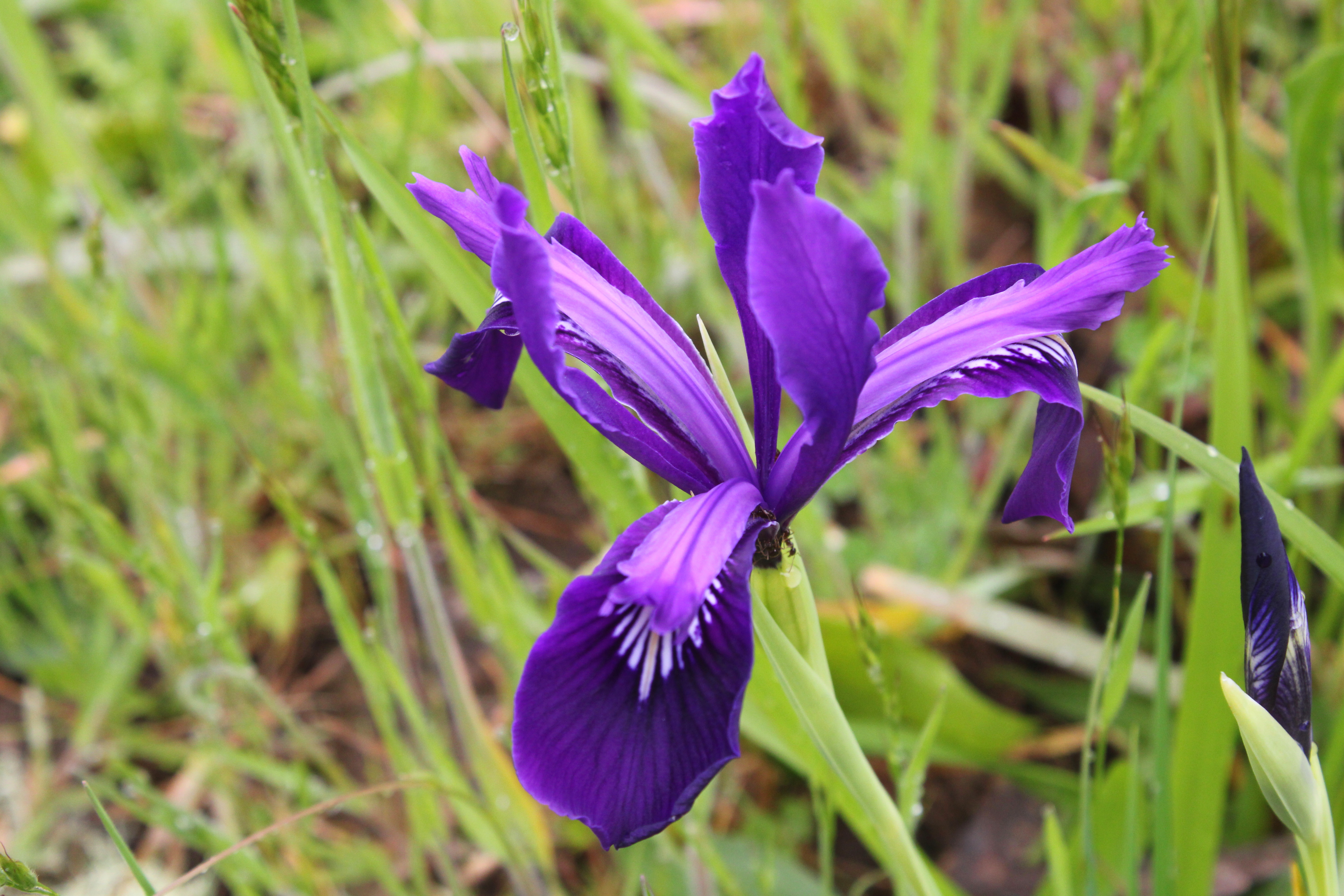
Douglas' iris decorated the grassy slopes

But if you are going to flame out on your Last Hike Ever, you might as well do it where it's scenic and this North Bank Medieval Torture Chamber Trail fit the bill. Spring was in full song and the vertical walls (oops, I meant to say "rolling hills") were covered with lush green grass. And if I were tempted to plop down on the ground in total exhaustion, the colorful red and oily leaves of the ever-present poison oak were more than adequate deterrent, the fear of itchy rash being sufficient motivation to remain upright, if not necessarily to keep walking. 

What a changing forget-me-not looks like

The wildflowers were putting on a show, best admired when bent over with hands on knees, lungs heaving mightily. Fiddleneck, wild iris, and Indian pink were all abloom, just to name several species from a cast of thousands. During one of my photo-ops while NOT resting, I spotted an odd little flower resembling a fiddleneck that sported flowers ranging from blue to yellow to white, all on the same flower head. It was a changing forget-me-not (Myosotis discolor), whose flowers start out blue but like my hair, turn white with age. I'd never seen this wildflower before, so that was kind of cool. 

Vista to a neighboring ridge

As we slogged on ever upward, crying for our Mamas all the while, the views began to entertain, expanding in direct proportion to the hard-won elevation we were gaining. Directly below the East Boundary Ridge, lay a quilted picnic blanket of farmlands extending all the way to the small town of Glide. Nearby and in the Habitat, were the wooded crest and grassy mounds of Middle Ridge, and we could peer directly down into the valley of Blacktail Basin, whose trail was a much easier route up to North Boundary Ridge than our current route, Brad.

Yay, the grade is merely uphill!

At about a mile and a half of hiking up a wall with a trail on it, the grade eased and the path morphed into what charitably could be called a "merely uphill" route. The dirt road undulated up and down a series of high points on the ridge and we all rejoiced at the newfound normalcy of the grade.

Fortunately, it never rained on us, despite the threat

At about the four-mile mark, the trail attained North Boundary Ridge which also served up its own daunting up-and-down route on its grassy crest. But if you hiked up the East Boundary Ridge Road to get there, well then it almost seemed like you were hiking downhill as the grade was nowhere near as demanding. On top of North Boundary Ridge, we availed ourselves the opportunity to snack, rest, regroup, and curse all things Brad.

Just when you didn't think the
hike could get any "better"

On the New Year's Day Worst Hike Ever venture, our foe back then had been Powerline Road. However, we'd be hiking down Powerline today and Brad assured us it was all downhill. I reminded him that no, there actually was a pretty good uphill pull to perform before we could say it was all downhill. At least there was no snow this time, although there was mud, wildflowers, and views as we descended. Some of us lay in the mud in protest when we gave up on the aforementioned steep climb on Powerline Road.

Pastoral scene on the steep
descent down Powerline Road

After a leg-braking, knee-taxing, soul-sucking descent down lush grassy slopes, we plopped down in exhaustion at the pavilion area, some of us face first. Brad served us lunch and snacks, if only to prevent us from kicking him in the rear for coming up with this hike. My own opinion is that he should have doled out ibuprofen instead of food to stay in our good graces.

What's a North Bank hike without poison oak?

For more photos of this hike, please visit the Flickr album.