 |
| Rheo commences the Best Hike Ever |
The hike began with an easy amble down the Habitat's entrance road and we gaily skipped along, a song in our hearts, if not on our lips. We made a left turn onto the trail and all happy songs immediately died in mid-trill, supplanted instead by a chorus of horrified shrieks sounding like so many Aztec death whistles. In front of us, looming like a grassy Great Wall of China (but way taller) was the East Boundary Road, seemingly rising straight up to Mars or beyond. Yikes, legs quivered and ached before we even began the dismal trudgery of hiking The Best Freaking Hike Never.
 |
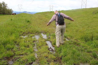
| Photo of the trail, taken while I was not resting |
About halfway up the first major slog, I think my calves began to cramp up, followed in short order by hamstring pulls, respiratory distress, hives, and maybe dilated pupils. Whew, this was hard work and I did lots of photography because I was NOT resting, no matter how much it may have looked like I might have been.
 |
| Douglas' iris decorated the grassy slopes |
But if you are going to flame out on your Last Hike Ever, you might as well do it where it's scenic and this North Bank Medieval Torture Chamber Trail fit the bill. Spring was in full song and the vertical walls (oops, I meant to say "rolling hills") were covered with lush green grass. And if I were tempted to plop down on the ground in total exhaustion, the colorful red and oily leaves of the ever-present poison oak were more than adequate deterrent, the fear of itchy rash being sufficient motivation to remain upright, if not necessarily to keep walking.
 |
| What a changing forget-me-not looks like |
The wildflowers were putting on a show, best admired when bent over with hands on knees, lungs heaving mightily. Fiddleneck, wild iris, and Indian pink were all abloom, just to name several species from a cast of thousands. During one of my photo-ops while NOT resting, I spotted an odd little flower resembling a fiddleneck that sported flowers ranging from blue to yellow to white, all on the same flower head. It was a changing forget-me-not (Myosotis discolor), whose flowers start out blue but like my hair, turn white with age. I'd never seen this wildflower before, so that was kind of cool.
 |
| Vista to a neighboring ridge |
As we slogged on ever upward, crying for our Mamas all the while, the views began to entertain, expanding in direct proportion to the hard-won elevation we were gaining. Directly below the East Boundary Ridge, lay a quilted picnic blanket of farmlands extending all the way to the small town of Glide. Nearby and in the Habitat, were the wooded crest and grassy mounds of Middle Ridge, and we could peer directly down into the valley of Blacktail Basin, whose trail was a much easier route up to North Boundary Ridge than our current route, Brad.
 |
| Yay, the grade is merely uphill! |
At about a mile and a half of hiking up a wall with a trail on it, the grade eased and the path morphed into what charitably could be called a "merely uphill" route. The dirt road undulated up and down a series of high points on the ridge and we all rejoiced at the newfound normalcy of the grade.
 |
| Fortunately, it never rained on us, despite the threat |
At about the four-mile mark, the trail attained North Boundary Ridge which also served up its own daunting up-and-down route on its grassy crest. But if you hiked up the East Boundary Ridge Road to get there, well then it almost seemed like you were hiking downhill as the grade was nowhere near as demanding. On top of North Boundary Ridge, we availed ourselves the opportunity to snack, rest, regroup, and curse all things Brad.
 |
| Just when you didn't think the hike could get any "better" |
On the New Year's Day Worst Hike Ever venture, our foe back then had been Powerline Road. However, we'd be hiking down Powerline today and Brad assured us it was all downhill. I reminded him that no, there actually was a pretty good uphill pull to perform before we could say it was all downhill. At least there was no snow this time, although there was mud, wildflowers, and views as we descended. Some of us lay in the mud in protest when we gave up on the aforementioned steep climb on Powerline Road.
 |
| Pastoral scene on the steep descent down Powerline Road |
After a leg-braking, knee-taxing, soul-sucking descent down lush grassy slopes, we plopped down in exhaustion at the pavilion area, some of us face first. Brad served us lunch and snacks, if only to prevent us from kicking him in the rear for coming up with this hike. My own opinion is that he should have doled out ibuprofen instead of food to stay in our good graces.
 |
| What's a North Bank hike without poison oak? |
For more photos of this hike, please visit the Flickr album.


No comments :
Post a Comment