Saturday, May 25, 2013

Natural Bridge (Upper Rogue River Trail)

The weather gods have a capricious sense of humor. First, they foisted a warm and dry May upon us; being experienced and knowing how things work, I resisted the enticement and kept my hikes low in elevation or on the coast. But, after my Grizzly Peak hike, I decided to go with the warm and dry flow and scheduled a hike into the Rogue-Umpqua Divide Wilderness. So, the weather that day was 21 degrees, 100% chance of snow, and 30 m.p.h. winds; needless to say the hike was canceled. On the subsequent weekend with the weather forecast calling for clouds and 40% chance of rain, we naturally enjoyed cloudless sunshine all day. Sometimes the weather gods's capriciousness can work in our favor, too.

The Rogue, on tranquilizers
This was a Friends of the Umpqua venture led by yours truly and there was only one brief uphill section and we didn't have to ford the river, most unusual for a Richard Hike. I must be losing my touch! At any rate, 19 Friends piled out of their cars at Woodruff Bridge. Normally, we head south on the Upper Rogue River Trail to Takelma Gorge but not today, we were off instead to see Knob Falls and Natural Bridge, both to the north of Woodruff Bridge.


I repeat:  SPRING IS FINALLY HERE!


Within the first several yards of trail we encountered spring flowers, the rushing Rogue River, blue sky above, and a green trail that tunneled through the newly leafed out vine maples. In other words:  SPRING IS FINALLY HERE! I don't think I hiked as much as I capered down the trail, kicking my heels like a new born lamb. Except lambs have considerably more hair than me, I probably more resemble a one-day old buzzard chick asking for regurgitated dead meat...no wonder buzzard chicks don't kick up their heels.  

Let the falls begin!
The Rogue River initially was on its best behavior, lazily coursing in tranquil and serene pools that reflected the green forest. Of course, that would change and a short uphill push took us to an overlook of Knob Falls where the Rogue became considerably rowdier. Basically more cascade than an actual waterfall, the Rogue seethes in a confined slot canyon as it tumbles 60 feet or so. A side trail drops hikers down a narrow ridge to a closer view of the action.

Note to self: Do not camp at a bottom of a cliff
Attaining the high ground overlooking the river, the path stayed high above the river. The trail was shady and pleasant but did provide occasional views to the river, now constrained to a narrow canyon with a massive lava cliff on the other side. Large rocks were in the river, delivered courtesy of the crumbling cliff.  
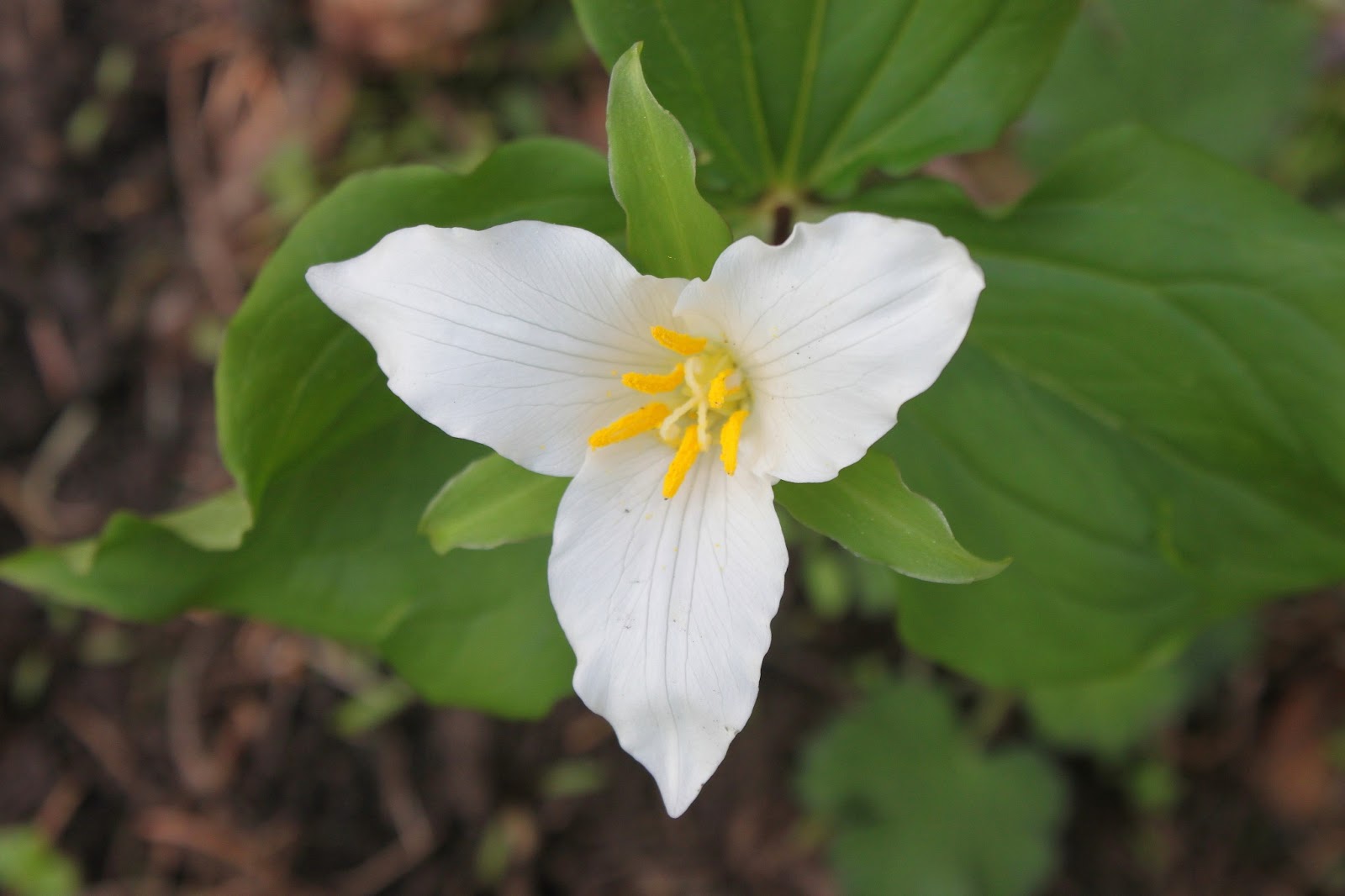
False Solomon seal
As mentioned before, spring was happening on the Upper Rogue and cameraholics spent a lot of time prone upon the trail, taking pictures of Oregon grape (all hail our state flower!), wild iris (my World of Warcraft user ID), creeping ceanothus (my Halloween costume), and the exotic looking calypso orchid (my stage name).  Pink and white spears of candystick were pushing up through the forest duff.  But really, this hike was all about the dogwood and vine maples.

Woof woof...it's a dogwood flower
Dogwood was blooming everywhere and I had ample opportunity to practice the craft of taking pictures of dogwood flowers against the blue sky.  The vine maples were leafing out and the very air seemed green underneath their leafy bowers draped over the trail.  As an aside, does anyone ever use the word "bower" besides long-dead poets and hiking bloggers? Anyway, it was definitely a green and white hike.


Quick, Rogue River, to the Bat Cave!
At about 3.5 miles our rugged little trail became paved. Paved? There's no paved in hiking! We had arrived at Natural Bridge, a popular (and paved) tourist spot on the Rogue. The bridge refers to a lava tube into which the entire Rogue River disappears only to surface a short ways further down the canyon. However, in spring when the river is full, the bridge is hidden beneath the river's flow. The whitewater is pretty impressive and entertaining nonetheless and is still worth a springtime visit.


Green trail
We continued on, leaving the hordes and the railed (Rails? There's no rails in hiking!) trails behind, returning to a bona fide dirt and rock path through rampant greenery.  After a lengthy lunch on a slab of bedrock next to the river rushing around an island, we continued onto the only uphill section on this hike.

Hi ho, hi ho, across the bridge we go
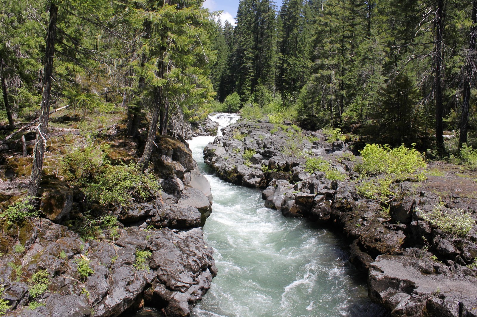
Climbing up a forested ridge and then descending back down, we renewed our acquaintance with the river. Here the river runs through a collapsed lava tube and is not very happy about that. However, the seething and roiling river was extremely scenic and we enjoyed several gawk-stops along the way before crossing the river on a footbridge.


Beautiful day in the Cascade Mountains

Now all we had to was walk the 5 miles back to the car alongside the river, flowers, and trees as the sunlight slanted in the late afternoon.  So, the weather report called for showers the next day too and and I anticipated piling into the car to enjoy another sun-soaked hike.  Turned out the showers that didn't shower on this hike were saved up for the next day as it just poured rain non-stop and once again, a hike was canceled.  Darn fickle weather gods!

Candystick
For more pictures of this hike, please visit the Flickr album.

Sunday, May 19, 2013

Blacklock Point

Blacklock Point is one of my favorite places on the Oregon coast.  The trail gets plenty of cliff time which makes my inner mountain goat happy and there are splendiferous views of the rugged coastline from Cape Blanco to Bandon. A variety of loop and trail combinations caters to hikers of all stripes when it comes to distance and destination.  And in spring, 10 foot rhododendron trees provide a pink hallway for hikers to walk through. Dollie was having a hankering for some quality rhodie time so we stopped here on our way home from Gold Beach.

Looks like one of my Sunday hats!
Beginning next to the Cape Blanco Airport under gray skies we headed down "Rhododendron Alley" on a trail flanked by 10 feet of tall vegetation.  Rhododendrons were blooming and we literally walked on flower petals strewn on the path, I would have felt more honored had the petals been strewn by fair maidens before me but I think those days are past. The trail, an old road actually, is often covered by large puddles in the spring but on this day only one of the regular wet spots forced us to do a walk-around.


Let there be light!
After a mile through lush forest with the wind sighing in the branches, we took the spur trail to Blacklock Point and began to feel like we had been unfairly treated on this hike. We were hiking under thick gray clouds but the ocean was relaxing under a clear blue skies. Just as I was about to file a complaint with management, somebody turned on the lights and we enjoyed the grassy cliffs in broad daylight.

Blacklock Point
There were prodigious views to be had from our clifftop vantage point:  to the south was the rock-infested bay arcing out to the Sixes River and Cape Blanco; to the north was the view towards Bandon, partially blocked by Battleship Bow; and right below our feet was the craggy point of Blacklock Point with its chain of islands seemingly tossed out into the sea in a fit of pique. Such magnificent views just require a contemplative sit-down and we obliged.


Candidate for "Best View Ever"
Returning to the Oregon Coast Trail junction, we continued north on a trail that ambled through dense coastal woods atop the bluffs. On occasion, we'd bushwhack to a cliffy viewpoint to admire and re-admire the views. Stars of the show were Blacklock Point, seen from the north this time; Battleship Bow, with a small waterfall leaping off nearby; but mostly, it was the cliffy ramparts marching north under some dramatic cloud cover.

Vancouver ground cone
Returning to the trail and forest, we stumbled across some ground cones. In the Siskiyou Mountains, the California ground cones are a common sight but these particular specimens were smaller and darker. Plus, the California ground cones are parasitic on madrone trees and there was nary a madrone in these woods. After some post-hike research, I've concluded that these were Vancouver ground cones, which are parasitic on salal and there was plenty of that around.  We do learn something every day, don't we?

Cleared for takeoff
At a campsite near a small creek (Where grandson Aiden and I had camped on a backpack trip last year), we opted to take the overland Oregon Coast Trail instead of the beach walk to Floras Lake. So the rest of the hike was through pleasant woods with rhododendrons blooming like little pink fireworks throughout the coastal jungle. Suddenly, there was no more jungle as the trail spit us out onto the airport runway, which was our "trail" back to the car.  Good thing no planes landed while we were on the runway!

For more pictures of this hike, please visit the Flickr album.

Coastal huckleberry, in bloom

Saturday, May 18, 2013

Brookings and Gold Beach road trip

This was a weekend of diminishing expectations. Originally, the plan was for Dollie and I to do a weekend backpack trip. However, in order to keep things relatively happy and calm in the O'Neill household, the destination was moved from the Siskiyous to the Oregon coast. When the weekend weather was prognosticated to be wet, the backpack trip morphed into a dayhiking weekend with a motel involved. When my hip popped while executing the dangerous and tricky getting-out-of-the-car maneuver, the trip became a road trip unless I wanted to hike with a walker.


Add a few throw rugs and call it a home
We began Saturday morning by hobbling through Azalea Park in Brookings. Well, to be honest, Dollie spryly walked while I gimped, dragging my right leg behind me. We were a week early for the Azalea Festival but we could nonetheless enjoy the tree-sized azaleas blooming in the park's manicured grounds. The rhododendrons were putting on a show with a veritable floral rainbow as rhodies of every color bloomed alongside the colorful garden paths.


Dollie considers going for a swim
After our park walk, we headed over to the coast proper, stopping first at Harris Beach. After a brief overlook it was time to head into the beautiful Samuel Boardman State Park. The Boardman park is one of the most scenic and hiker friendly stretches of the Oregon cast and we stopped at Lone Ranch Beach, Cape Ferrelo, and Whalehead Beach. It seemed like I was walking my way out of whatever injury I had accrued so we actually took a short walk on the Oregon Coast Trail on the grassy slopes of Cape Ferrelo. Dollie provided some amusement crossing Lone Ranch Creek on some slick logs but managed to avoid an early spring swim. 

Bowl, at Indian Caves
Feeling "walky" by now, the short hike to Indian Sands was in order. A brief descent through a coastal forest on a trail covered with slugs and mating centipedes brought us onto the sands. The dunes are kind of oddly located, being perched high atop a rocky cliff. The ocean pours into an incredibly scenic rocky bowl replete with waterfall and a rock arch. Wild iris was blooming everywhere, augmented by scarlet Indian paintbrush, white wild strawberry, and purple lupines.

Ah-choo!
Returning to our rustic cabin room, the last little item on the day was a pre-dinner walk along what I presume is Gold Beach's Gold Beach. The clouds were dark and moody (no sunset on this evening) as the wind gusted, messing up what little hair I have. Lupines and beach peas were blooming away in the dunes but the Scotch broom was the invasive star of the show. Brought to our shores by those darn Scottish settlers from days of yore, the plant has made a happy home for itself in the New Country. Incredibly invasive, the broom crowds out native plants and is not welcome (Curse you, McBroom!). Despite the pernicious aspects of the shrub, the bright yellow flower masses are quite spectacular, unless you are hay-fever afflicted like my wife.

Yup...
So, despite the lowering of standards for the weekend, we covered quite a bit of ground and managed to get some hiking in...and I didn't even need a walker! 

Visit the Flickr album for more pictures of this wonderful little corner of the Oregon sandbox.
Gold Beach at twilight


Saturday, May 11, 2013

Grizzly Peak

It seems to me that Grizzly Peak should be to all the other Bear Peaks in Oregon what grizzly bears are to a run-of-the-mill ordinary black bear. In ursine terms, a 5.4 mile hike somehow seems to be more of a koala bear of a hike. However, hiking buddy Glenn assured me the hike was worthy and since I'd never been, Saturday morning found me driving down to Ashland.

Oregon anemone
After a pleasant drive through purple stained hills (the deer vetch was in spectacular bloom) dotted with newly leafed out oaks, I was joined at the trailhead (which had a great view of Mount McLaughlin, by the way) by Glenn, Carol (Mrs. Glenn), and Karen (Glenn's sister). And with a fierce grizzly-like "Grrr..." we set off on the trail.

It was a trillium show in the forest
The trail wasted no time angling uphill through a shady fir forest, the quiet of the forest getting interrupted by the heavy breathing of a certain panting hiker from Roseburg. The undergrowth vegetation was still tamped flat by the recently departed snow but the trilliums and snow queen were sending up their early spring blossoms. The heart shaped and fragrant leaves of wild ginger were also spotted but a cursory examination under the leaves revealed none of the brown and hairy flowers.

See the blackfly?  I didn't, either!
Periodically, the trail would break out into open meadows with yet a few snow patches in them. The whole vibe reminded me of the Rogue-Umpqua Divide Wilderness.  Spring was in the air, literally, and each leg was bitten in turn by a welt-raising blackfly which started me yearning for the insect-killing cold of winter. I imagine mosquitoes and hikers will be renewing bloody acquaintanceship before long.

Disco lives!
After an uphill mile or so, we reached the intersection with the loop trail and opted to hike the loop counterclockwise. The trail leveled out and an unassuming  rocky knoll  flanked by thick patches of diminutive glacier lilies marked the official Grizzly Peak summit. Because of the dense fir forest, there were no views to be had but Glenn and I stood on the summit just because.

Smoky view to Medford
Intermittent views were enjoyed while the trail contours the edge of the broad summit; Mount Thielsen, Union Peak, and the Crater Lake rim were all spotted in the smoky haze. Views were somewhat limited due to hazy smoke, presumably from prescribed maintenance burns nearby.  The fires of the non-prescribed variety are coming because this has been a hot and dry spring.

Walking through the ex-forest
In 2002, the East Antelope Fire charbroiled the forest on the west side of of the mountain.  West antelopes were relieved and hikers have since been grateful for the fire really opened up the views by removing all that annoying forest.   The trail hugs the peak's rim under some rock formations with blooming wildflowers.  But mostly, it's all about the views, even on a hazy day.

Emigrant Lake, below Pilot Rock


Ashland lay nestled in a valley virtually 4000 feet below as the slopes dropped precipitously away from our mountain perch.  Rising on the other side of the valley were the snowy Siskiyou Mountains stretching from Mount Ashland to Grayback Mountain.  To the south was ghostly and very tall Mount Shasta with Emigrant Lake reposing below Pilot Rock.  To the east were the peaks marking the caldera of the Mountain Lakes, one of my favorite haunts.

Mission bells, they toll for thee
When not oohing and aahing at the clifftop panorama, we spent some time on our knees and bellies taking pictures of the many wildflowers blooming in the rock gardens.  Notable were coastal delphinium (a low growing larkspur), Hall's desert parsley, Indian paintbrush, and dwarf hesperochiron which incidentally used to be my nickname on the dude ranch...and that's all I'm saying about that!

All good things come to an end, including hikes, and we closed the loop and reentered the forest.  But, hey, at least it was downhill to the car.  So, while this hike logged an un-grizzlylike 5.4 miles, because of the great scenery, I rate this trail at four Tibetan blue bear paws.


For more pictures of this hike, please visit the Flickr album.

Saturday, May 4, 2013

Three Sisters Loop

This last weekend, I hiked the Three Sisters Loop. That phrase just rolls off the tongue in robust braggadocio with a just hint of studied nonchalance. But no, the hike was not the formidable 75 mile loop (surely covered with snow, this time of year) around Oregon's massive Three Sisters near Bend. Nope, these three sisters are a set of fairly nondescript cinder cones in the desert badlands of Lava Beds National Monument, just barely on the California side of the Oregon-California border.

I learned the desert can get hot
For some reason, desert hiking had been calling me so Friday I hopped in the car after work and drove the 4 1/2 hours to the monument. Arriving at the tail end of a spectacular sunset, camp was quickly set up in the fading light. It had been fairly warm but the temperature quickly dropped into the mid-40's. The temperature in the desert can rapidly change from hot to cold for no apparent reason, just like a teenager's mood swings.

Schonchin Butte, from the Bunchgrass Trail
Starting out in the early morning, the day was sort of sunny as puffy white clouds provided intermittent shade. A chill wind blew, though, and the cool temperature was just perfect for hiking. The Three Sisters Loop began from the campground on the Bunchgrass Trail which angled along the base of Crescent Butte, yet another small cinder cone.  There were so many cones dotting the landscape, it was as if the earth had goosebumps.

Dwarf monkeyflowers
I'm not sure if it was spring in the desert or not, or if there is even such a thing as spring in the desert, but thick mats of phlox were blooming in the rocks and volcanic ash. I saw some specimens of blazing star, cinquefoil, currant, and dwarf monkeyflower. That was it for the flower "show" as the unblooming sagebrush was the dominant life form on the Lava Beds planet.


To the Bat Cave, Richard!


At the foot of Crescent Butte, a right turn was made onto the Missing Link trail and somehow that was fitting. A mile later through the treeless sagebrush, the trail ended on the Skull Cave (also fitting, for some reason) Road, requiring a short road walk to the cave parking lot. I didn't have caving equipment so I just walked to the entrance and peered into the inky blackness of the cave tunnel.  Inside, it was dark and cold like yesterday's coffee in the mug on my desk. Actually, the coffee is probably older than yesterday to judge by the rafts of gray mold floating on top.  

Hungry for hikers
Caves are a large part of the Lava Beds experience and as I continued on the trail (now called the Lyons Road) all manner of sinkholes, deep cracks, and cave entrances proliferated right and left of the trail. The caves are caused by collapsed lava tubes and I began to doubt the so-called solidity of the ground I was hiking upon. I am glad to report no hikers were swallowed up by the earth this day, no feeding the caves for me!

The Three Sisters
Resembling black pimples on a wide cheeky expanse of sagebrush, the Three Sisters came into view as I took another right turn onto their namesake trail. Normally, these low buttes would not be worthy of attention but since they were the only item of interest within a couple of cubic parsecs, they had become a noteworthy hiking destination.  Obviously, the Three Sisters were the  little sisters of the Lava Beds household.  Probably bratty, too.

View from the "campsite"
My guidebook suggested camping (I was dayhiking, no camping for me this time) at a tree near the buttes and there it was, a lone juniper as noteworthy as the buttes since they were the only things higher than knee-height. It was here that the wind eased up, clouds quit forming overhead, and the sun began to bake me like a candied yam. Coming from the cool jungles on the west side of the Cascades Mountains, I began to suffer from SDS (shade-deficiency syndrome). Or as King Richard said (with apologies to William Shakespeare) "shade, my kingdom for some shade!"

What constitutes jungle growth in the desert
Continuing east, the trail left the monument and entered the Modoc Forest and junipers began to appear. While my west-side Cascades sensibilities would deign to apply the word "forest" to this collection of low growing junipers, there were more than one and that constitutes a forest in these parts. At any rate, the shade was enjoyed at a lengthy lunchtime dalliance in what would be the first of several shade stops.

Sketchy trail


The farther the trail went from the monument, the sketchier the tread became as the ubiquitous sagebrush was intent on reclaiming the land from human intrusion. The only sounds heard were my boots crunching on the pumice and volcanic ash and the scolding from the blue jays. And maybe the odd hiker fart every now and then.  Just as I was getting nervous about getting lost in the desert, the trail looped back to west and reentered the monument. And in the monument the trail tread became clearly visible again and there was much relief.

Pahoehoe lava
Several miles back into the monument, the trail passed an interesting lava formation consisting of thick braids that had congealed, preserving the hot molasses drip for all eternity. As tired legs stumbled forward with several more opportune shade stops, the clouds resumed forming, the wind started blowing and it felt like rain was on the way. By the time I returned to the campground, the wind was in full force and the rain started.

Let the sunset begin
Of course, a half hour later, the clouds disappeared and the day went semi-sunny again, allowing campers to enjoy a spectacular sunset. Large clouds formed over Tule Lake and it was obvious the people of the lake's namesake town were getting rained on. The sunset was a great reward for a tough hike in addition to being able to truthfully and casually say "I hiked the Three Sisters Loop last weekend!"  

For more pictures of this scenic little park in California, please check out the Flickr album.

Green tiger beetle