Saturday, October 31, 2020

North Umpqua Trail (Hot Springs Segment)


Just when you think you've seen it all, you find out you haven't. We were hiking on the North Umpqua Trail on Halloween day and as I approached Columnar Falls, there was a comely lass posing in front of the falls for a camera dude squinting into the viewfinder, kneeling on the trail and totally engrossed in his photography avocation. Her attire and general vibe were medievally rustic as she was wearing a brown Little Red Riding Hood-style cape and hood. At that particular moment, I was picking out an off -trail route down to some logs for a lunch spot and at first glance vaguely noticed that she was wearing matching flesh-colored shirt and pants. On a second look though, the odd flesh-coloring was explained by the fact didn't have any clothing on at all other than the cape, which may have led to a third and fourth look just to confirm the second look. And there she was, standing on the North Umpqua Trail, close enough for me to notice a whole flock of goose-pimples to go along with her Oregon grapes and deer ferns, euphemistically speaking. We inadvertently made eye contact, forcing us to awkwardly acknowledge each other's presence:

Me: Hello, how are you today?
Lady Godiva: I'm fine, doing well. 
Me: Aren't you cold? 
Lady Godiva: Yes.  

That had to have been the oddest conversation ever to take place between a fully-clothed man and an unclothed woman in a freezing forest in the entire history of humankind, but hey, it was Halloween at Umpqua Hot Springs, after all!

Plenty of clothing on our group

The fully-clothed part of our hike began at Toketee Lake, the comparitively warm waters covered with a thin layer of mist. It was frosty cold so unlike Miss North Umpqua Trail, we were all properly attired in ski caps, mittens, sweaters, sweatshirts, parkas, or some variation thereof. The first half of the hike was through shady woods so we really felt the lack of warm sun as we hiked. The forest was damp with condensation and water drops hung off of leaves, twigs, and hiker's noses.

The trail was mostly leaf-littered

Between my last hike here and this current edition, leaves had fallen en masse onto the trail so our feet swished through them as we hiked. Because of the near constant shade, the fall colors were muted, tending toward pale and light yellow hues. The waters of the nearby North Umpqua River were dark and black, the lack of color also attributable to the lack of sunlight. 

The forest was a mix of color and trees

At the halfway point, the trail crossed over the river and I compulsively scanned the banks and rock islands for my hiking pole that had been lost to the river currents during my last hike here. Didn't see it, but then I didn't really expect to. The bridge crossing was notable in that the crossover did put us on the sunny side of the river where autumn really began in earnest. Let the fall colors begin!

Autumn fanfare

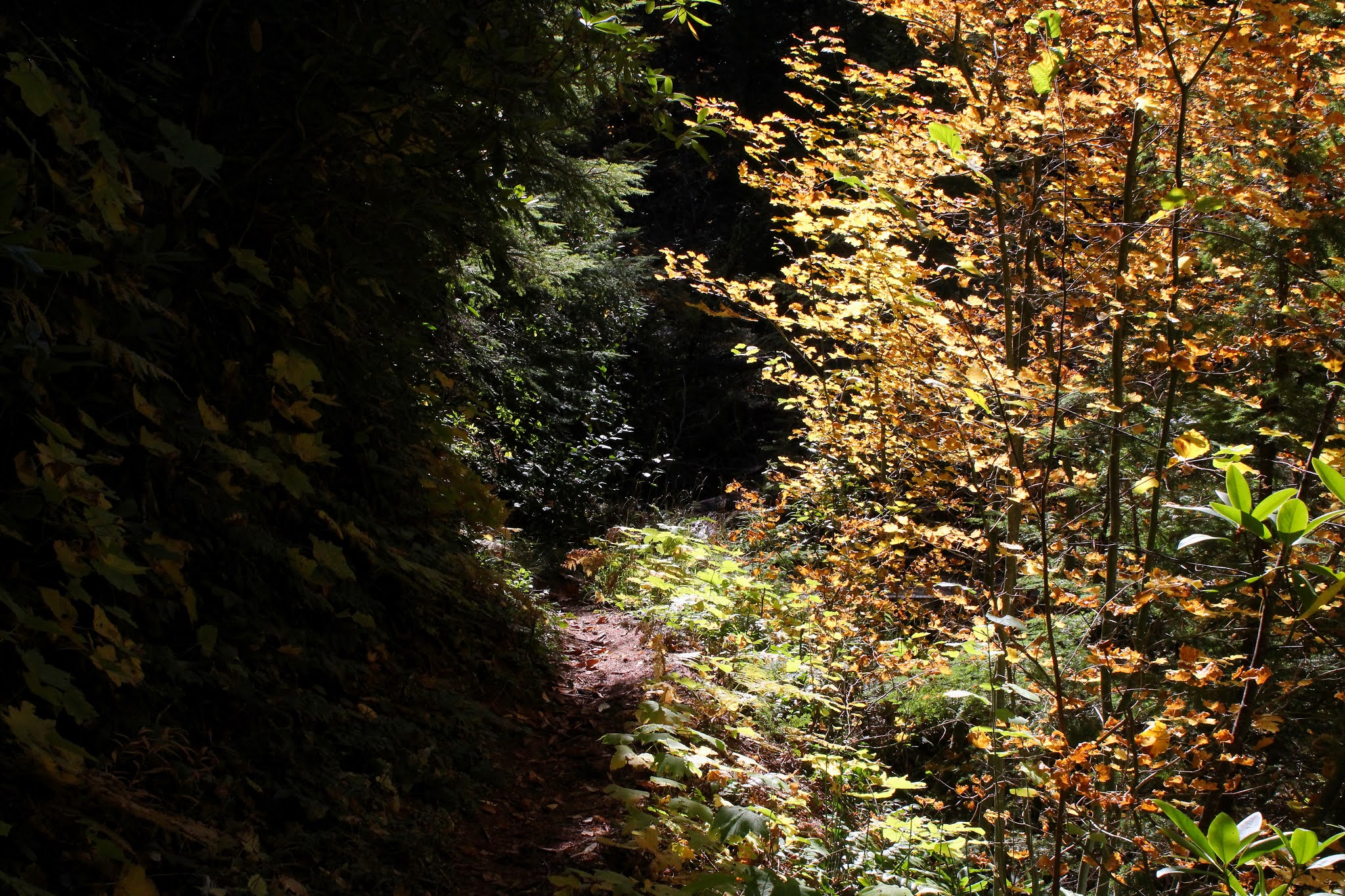
The forest understory was mostly comprised of the ever ubiquitous vine maple, and the small trees were really putting on a show with yellow, orange, and red leaves all lit up by sunbeams like so many multihued stars in the universe's brightest galaxy. Tall firs interspersed with bigleaf maple trees loomed over all lesser life forms growing or hiking underneath, the big leaves glowing bright yellow in the ample sunlight higher up. Needless to say, hikers with cameras soon lagged behind those without.

Penny and Missy cross the North Umpqua River on a rainbow bridge

Some of our crew turned around at the stout footbridge spanning Deer Creek while others continued on. Some of our group that had never seen the delicate beauty of Columnar Falls so the remaining contingent hiked on for another mile and a half to the falls where we observed a delicate beauty of a different sort as we ate lunch. Across the North Umpqua River and high on a slope, were the pools of hot water collectively known as Umpqua Hot Springs and while we ate, groups of hikers would arrive at the springs and immediately begin removing clothing. Across the river, there was one last pool of hot water with a bunch of naked dudes whooping it up. We, with our ski caps and down jackets, were severely overdressed but on the plus side, we were quite comfortable in the chill outdoor air.

Sun illuminated the autumnal leaves

All good things come to an end though, and we packed up our gear and returned to the trail. The last time I saw Aphrodite of the Falls, she was holding a ceramic moon and sun over her head, posing in front of the falls while her photographer friend captured the scene. I couldn't help but be captured by the beauty of what I was witnessing and of course I am referring to the Canon ESO 5D Mark IV camera in his hands. The Umpqua National Forest Nymph still looked cold, though.

Tinder fungus thrives on a log cut

For more photos (none of which are of our Naked Lady of the Woods, sorry) of this hike, please visit the Flickr album.

Thursday, October 29, 2020

Bohemia Mountain and Fairview Peak


As we were eating lunch on top of Bohemia Mountain, Edwin asked me if I knew how the mountain had got its name. "C'mon, ask me a hard one" I replied "It was named after the guy that discovered it. His name was Bo, last name Hemia!" I ate the rest of my lunch alone, banished to an obscure corner of the small mountain with large views, my best comedic material wasted on the unappreciative.

A small piece of Bohemia Mountain

It had been a long drive to the Calapooya Mountains for this pair of relatively short hikes, and the last ten miles or so were really slow going as the gravel road to Bohemia Saddle was so atrocious that even my normally fearless Jeep cringed. Naturally, it felt good to get out of our vehicles and stretch our legs. Eager to begin walking, we headed up the trail to our first destination, the aforementioned Bohemia Mountain.

Oof, this was steep!

Sometimes you have to be careful about what you wish for. We (Edwin, Penny, Cleve, and yours truly) all wanted to start walking right away but after a few minutes on the steep trail to Bohemia's summit that had us all gasping within minutes, going back home seemed to be a suddenly reasonable and viable alternative. But, that wouldn't be hiking now, would it? So, we stubbornly continued trudging on up the trail.

A fair view of Fairview Peak

As the trail gained elevation at its prodigious rate, the view gradually began to improve as the forest thinned out. Rocky cliffs loomed on the uphill side as the trail traversed some avalanche basins and the attendant rock piles associated with them. There were several user trails leading to various viewpoints and from those overlooks, we enjoyed the sight of neighboring Fairview Peak with its lookout affixed to the top like a misplaced oil derrick. 

Eugene was in the fog all day

Before too long, the trail leveled out and voila, we were on Bohemia's summit. Bohemia is just another small mountain in the relatively low Calapooya Mountains but oh, the things you can see from the top! To the north and west were the rugged canyons of the Willamette and McKenzie River systems and beyond were the cities of Springfield and Eugene reposing side-by-side in the wide and vast Willamette Valley. While the rest of the entire world, such as ourselves, were enjoying a superlative blue sky with comfortably mild temperatures, it was no doubt a gray and misty day in Eugene. The metropolitan sprawl was hidden by a large fog bank parked in and over the valley and we took snarky delight in imagining the Eugenians shivering in the gloom. The Cascades were parked on the eastern skyline and we had a good look at the chain of peaks running south between the Three Sisters and Mount McLaughlin. 

Oof, this was steep all over again

The next object of our affection was neighboring Fairview Peak. There is no official trail to the summit but a rough gravel road was there for our disposal once we hopped over the gate barring non-official vehicle traffic to the top. Mind you, the gravel road was made for vehicles and their powerful motors but to our puny little human engines, this was another steep hike. Although, we should have been used to the grade by now because the slog up Fairview Peak was just as leg-taxing as the path to the top of Bohemia Mountain was. Cougar tracks were spotted on the road and no doubt the big cats just effortlessly sauntered up the trail unlike us human weakling types.

The lookout tower on Fairview Peak

The summit was graced with the lookout tower, its intricate latticework of fairly new lumber contrasting nicely with the deep blue sky above. A construction crew was performing maintenance on the structure and although they seemed like nice fellows, they did not allow us to take the stairs to the top, citing "orders are orders" as the reason for barring the way. But the views from Fariview, just like Bohemia, were tremendous and we did not feel cheated in that regard.

Scott Mountain (right) and the smoke filled North Umpqua River valley

It was a pretty fair view from Fairview Peak and we could see Mount Hood on the northeastern skyline which meant all of the Oregon Cascades were visible from border to border, as Mount McLaughlin was still visible to the south. Allegedly Mount Shasta, in California, can be seen from Fairview but haze in that direction prevented us from doing so, or else we were mistaking Shasta for McLaughlin. We were somewhat surprised to see Scott Mountain (right next to the town of Glide) relatively nearby, looking as flat-topped as a 1950s crew-cut. It was kind of funny to think about the fact we had driven over two hours on a circuitous route just to see a small peak that was a normally a mere 20 minute drive from Roseburg. Scott Mountain had been in the middle of the Archie Creek Fire and the fire scars on the mountain were clearly visible. Next to the mountain was the North Umpqua River valley, filled with smoke from the still smoldering fire remnants.

They say the spirit of Bo Hemia still haunts the mountain

So, all day long I'd been joshing my compatriots about that Bo Hemia guy that discovered Bohemia Mountain. But in all seriousness, Edwin said he thought the mountain had actually been discovered by an explorer named Cal, but he couldn't remember the last name. "It was Cal...um...uh...oh I remember his name now!" he said, snapping his fingers for emphasis "... it was discovered by Cal A. Pooya!" Cal A. Pooya, as in the Calapooya Mountains. Get it? I did and while I hate being outpunned, all I could do was gracefully acknowledge my defeat, formally conceding to Edwin "Nicely played, Sir, nicely played!"

Mounts Thielsen and Bailey on the distant skyline

For more photos of this hike,
please visit the Flickr album.

Thursday, October 22, 2020

North Umpqua Trail (Dread and Terror Segment)


The trail had been etched into rocky cliffs above the river but here, the trail was soft soil and mud, and was badly eroded. The tread was narrow in width and inconveniently sloped off-camber toward the downhill side. More deer track than trail, the path was moist, muddy, and slippery as it rounded a cliff face, and there was not a lot of room for error. About fifteen feet below the precarious path, the North Umpqua River flowed, the waters deep and dark and only too willing to accept any hikers falling into its watery black embrace.

Boots (and feet contained within) got wet wading across creeks

Basically, the preferred mode of getting around this danger spot was to lean into the cliff, brace with the cliff-side arm for balance, and then step across as far as possible. When it was my turn, I stretched my leg across the worst of the faint trail and then transferred weight from the back foot to the front foot. Uh-oh, my front foot did not get traction and began sliding down to the river. No problem, I turned into the cliff and grabbed hold for a steadying purchase. Uh-oh again, for the cliff was mostly mud and instead of clinging to temporary safety, my front foot continued its slide and now both hands contained a fistful of soil and were not attached to anything solid other than my arms. Ok Richard, this is the appropriate time to panic, so I did my best desperate Wiley E. Coyote impression. You know the one where he is temporarily running in mid-air before falling off a cliff? That was me, right then! But somehow, I got just enough traction from my two frantically flailing feet to flop across to the accompaniment of Patti making some kind of squeaking inhaling noise like a mouse with whooping cough. Horrified, she had witnessed the whole episode. How's that for experiencing some actual dread and terror on the Dread and Terror Segment of the North Umpqua Trail?

The always graceful and delicate Columnar Falls

My near-catastrophe notwithstanding, the Dread and Terror is mostly benign and is one of the prettier sections of the North Umpqua Trail. Beginning at the Umpqua Hot Springs trailhead as we did, the first mile or so was all about the numerous springs and creeks gushing up and out of the earth, flowing over and onto the trail. After crossing Loafer Creek (which was NOT named after me no matter what Mrs. O'Neill says) we came across ethereally graceful Columnar Falls. More seep than actual waterfall on a cliff face comprised of basaltic pillars long since mossed over, the constant moisture sustains a lacy set of trickles that make the falls a very special place, indeed. 

The cliffs leaked water throughout the hike

Still within a mile of the trailhead, we ran into a couple of surprises in the form of Surprise Falls and Surprise Creek, both so named because, unannounced and fully formed, they jump right out of the ferny earth next to the trail, figuratively shouting "Surprise!" as they do so. There were also many other springs and seeps small enough to remain nameless as they toil in anonymity for all of perpetuity. They do a fine job too, as evidenced by the constant moisture, moss, and ferns growing on and all around the trail.

Water running on the trail was a thing

The route was a basic study in alternates, for the trail would amble through a lush and mossy forest next to the North Umpqua River and then clamber high up on a cliff-hugging overlook of the river coursing in the bottom of its canyon. Rinse and repeat for at least the next four miles, which was the extent of our venture. It's hard to get bored on this hike because the scenery varies frequently as the miles accrue. 

Either a mushroom or an alien pod baby's egg

Down in the forested sections, there was a burgeoning explosion of fungal growth. Seems like everything from dog vomit slime mold to coral fungus were busy consuming decaying logs and thick layers of forest duff. It was a veritable mycological rainbow with fungi of all color, sizes, shapes, and body types slowing down hikers with cameras. 

Puddle 1, Terry 0

At nearly the four mile mark, the trail went swampy as it traversed a boggy creek bottom. Boots and pants legs were soon wet and muddy, and hikers were mostly happy. I slipped into a knee-deep hole there too, but at least I was not the only hiker in our party to do so. Shortly afterward the seven of us plopped down on the forest floor to eat lunch and let wet pants legs dry out. And after our lunch 'n laze, we then headed back the way we had come. And I of course, still had that scary near-fall experience waiting for me.

The sunlight set the woods on figurative fire

On the return leg, the thin sun finally made it down to the forest floor, warming souls and hearts alike, illuminating the autumn leaves as if they had been plugged into a wall socket. It had been a cold day while hiking in the shadows and the fall colors had been rather muted until the sunlight hit. But with the sun now satisfying its contractual obligations, the vine maples were gloriously colorful and once again, those of us with cameras soon found ourselves lagging behind while other hikers simply enjoyed the soft golden glow underneath the trees.

The spot of my dread and terror

What really cheesed me about my near fall is that I had taken a photo of our little group making the step-over (completely, without incident too, I might add). Looking at the photo, it doesn't seem like it was all that dangerous but in this case, the photo lies, it really was more treacherous than an ex-spouse who also happens to be a pirate. But fortunately, all turned out well and let's not be repeating any more Surprise Falls (non-waterfall related context) again! 

Where light and dark meet

For more photos of this hike,
please visit the Flickr album.

Wednesday, October 21, 2020

Oregon Coast Trail (Old Highway 101 to Humbug Mountain State Park)


The genesis for this hike came about when I was cobbling together a plan for last month's Humbug Mountain hike. The hike on Humbug Mountain is a short five'ish miles long, so I was looking for some way to come up with a longer route. In particular, my search entailed finding a way down to the beach at the base of the mountain itself. However, a shiny object distracted me long enough to make me forget about the beach and the object in question was a section of the Oregon Coast Trail that starts about two miles south of the small town of Port Orford and ends at the picnic area on the south side of Humbug Mountain. Now, I've driven this stretch of coastal highway many a time but had never noticed a trailhead where the map said there was a trailhead and my curiosity now piqued, I headed to Port Orford like a landlocked Captain Ahab in search of the Great White Trail.

This way to hiking paradise

Found it! The trailhead was on an unsigned road that looked like it might be someone's driveway (but I drove up it anyway!). However, there were several cars parked next to a gated road and lo and behold, an Oregon Coast Trail marker was affixed to a post right next to the gate. Adding my vehicle to the car collection at the gate, I laced up my boots, eagerly anticipating a full day of hiking on a rugged coastal track, even though the trail suspiciously resembled a road.

Hard to believe this used to be a two lane highway

Ah, there's nothing like the hard feel of unyielding pavement underneath the boots and I began to wax nostalgically about hiking on a freeway, something I've never done before but I'm being sarcastic here. The trail was actually the once and former Highway 101 and while encroaching vegetation had narrowed the repurposed highway considerably, a faint yellow line was still clearly visible in the middle of the road, along with maybe an equally faint skid mark or two.

Redfish Rocks, from the first of several viewpoints

Normally, I don't get too excited about walking on a roadway, abandoned or not, but I've been known to become rather ebullient over signs labeled "Viewpoint" with real dirt paths behind them. One such matching set of trail and sign appeared after about a half mile of hiking and I heeded the siren song of a real trail. The short path led to a grassy overlook with a strategically-sited bench on it, and I thoroughly enjoyed the view of nearby Point Orford, Humbug Mountain, and some rocky islands known as Redfish Rocks bobbing in the ocean. As I gawked at the coastal scenery, several water spouts advertised the otherwise hidden presence of whales in the vast blue sea.

Island Rock, off in the distance

After a short stop 'n gawk, it was back on the old road-cum-trail which then crested at a high point with a superb overlook of the Pacific Ocean rolling onto an inviting beach at the base of Humbug Mountain. In the ocean offshore of Humbug Mountain was the unimaginatively named Island Rock. If Island Rock is the only name the island namers could come up with, why not just call it Rock Rock? Or, maybe Island Island? Especially since a small pointed rock nearby makes the two islands collectively appear as a whale and tail. Whale Island, anyone? Anyway, after some oohing and aahing at the overlook, it was back to the trail inclining downward to the campground located in Humbug Mountain State Park.

Now we are talking about gorgeous trails!

Maple trees arched over the still-paved trail, with most trees just starting to turn yellow with autumn's looming advent. After crossing Dry Run Creek (which was not dry nor was I running) on a well constructed bridge, the forest morphed from maple to myrtlewood with tall trees of each specie hovering over a deeply shaded road coated with a light layer of fallen maple leaves.The old highway did come to an end in the campground but never fear, the Oregon Coast Trail resumed on a dirt path that provided a butt-kicking grade as it went up and over a deeply wooded ridge.

The myrtlewood forest was absolutely sublime

Burning quads, glutes, and other assorted aching body parts aside, this was my favorite part of the hike. The forest was mostly comprised of myrtlewood trees, and the deeply shaded trail was perfumed with the sweet aromatic incense of their leaves. Once the trail crested, it then bottomed out next to Brush Creek coursing below the trail, the creek barely visible in the surrounding brush. Given the bucolic splendor of the peaceful woods, it was almost disappointing to enter the manicured lawns and civilized picnic tables of the Humbug Mountain day use area. 

A spider patiently waits for a hiker to blunder into its web

After lunch and a perfunctory visit to the forlorn ruins of long-abandoned Brush Creek Fishery, it was back the way I had come while the afternoon light slanted poetically through the branches of tall maple trees. Because the old highway is paved, it stood to reason I'd eventually encounter a cyclist or two. One such cyclist was looking for a misplaced husband, stating she would wait for him at the park entrance. Sure enough, I ran into him looking for his misplaced wife who had sped by him, oblivious to his impromptu stop to heed the call of nature. Feeling like a trailside marriage counselor, I gave him her location and hopefully the happy couple is still reconciled because it's always nice to come back from a hike with valuable karma points in hand.

Silvery sea on the return stage of the hike

For more photos of this hike,
please visit the Flickr album.

Friday, October 16, 2020

Rogue Gorge - Upper Rogue River Trail Loop


The genesis of this hike began when younger brother Don prostrated himself at my feet, begging "O wise and wonderful Older Brother, I am but a mere gnat caught in the glittering web of your awesomeness, Please o please, can you take me on one of your hikes and render me worthy as I bask in the golden glow of your presence?" Now, if you run into Don out on the street somewhere and question him as to the veracity of my account, he may vehemently deny that such a conversation ever took place. But, my rejoinder is that my blog is part of the Internet and if it's on the Internet, then it must be true.

Just a beautiful day for a hike!

The Cascade Mountain Range in Oregon are a chain of tall peaks covered with countless acres of tall conifers. Being evergreens, the conifers tend to ignore that autumn foo-foo stuff of bright colors and all that nonsense. What's wrong with being tall and dark green, anyway? Nothing, but autumn can be so much fun when leaves of trees so inclined celebrate winter's impending arrival with a burst of leafy color. So what's a hiker to do in order to enjoy the autumn plumage? Why, you must go where the vine maples grow, and that's how younger brother Don and I found ourselves on the Rogue Gorge Trail once the proper amount of groveling had taken place.

The Rogue River churns in its namesake gorge

Don had never been to the Upper Rogue River so I was able to hike vicariously, seeing the hike anew through his eyes. Our hike began at the Rogue Gorge which is a geologic marvel in its own right. Here, the Rogue River flows through an ancient lava tube whose roof had collapsed millenia ago. The river is all white water as it angrily seethes at the bottom of the narrow gorge and the view thereof was a great way to begin the day's venture.

The river reflects

After gawking at the gorge, we set foot on the Rogue Gorge Trail which follows the river to touristy Natural Bridge. It didn't take long for this to become the quintessential autumn hike. The riverbanks were bathed in warm sunlight and the vine maples were in bright orange, red, and yellow form. Dogwood likewise went colorful but tended more toward a pinkish hue. The river was tranquil and serene here and the surrounding colorful foliage and trees painted watercolor reflections on the river's surface.

Colorful leaves were one of the stories of this hike

The next few miles were mostly a level walk underneath either a deep blue sky or vine maple leaves illuminated by the bright sun like so many millions of colored lights. Don also had a camera so he wasn't any more annoyed than usual with his wiser and more handsome big brother when much mutual photography ensued. 

Much photography ensued

The basic calm tenor of the river changed when the river used the readily available slot of yet another collapsed lave tube to funnel into, raging and frothing with angry white water as it did so. A picturesque footbridge crosses the river here and the bridge makes a convenient place to stop and take photographs of the scenic river constrained by unyielding black and gray lava.

The river divides around a large boulder

More geological and/or riverine delights awaited us at Natural Bridge after another mile and a half of riverside walking. Natural Bridge is where a lava tube did not collapse and the Rogue River enters the tube and disappears completely from sight like a child playing hide-and-seek, only to emerge about 75 yards downstream, ready to resume its long above-ground journey to the Pacific Ocean. Don was suitably impressed, gushing "Gee whillikers Totally Awesome Big Brother, this is amazing!" while I, as a jaded and faded Upper Rogue River veteran, stifled a yawn and replied. "What, that old thing?"

Just follow the Yellow Leaf Road!

Actually, the bridge part of Natural Bridge was the least visually interesting thing at this popular tourist spot. More fun was the river thundering in its narrow defile in a series of thundering cascades and roaring falls. Much photography (times two) ensued. And from there, we decided to return via the Upper Rogue River Trail for variety's sake.

Vine maple, putting on its usual autumn show

The Upper Rogue River Trail was initially a pleasantly level stroll along a fairly well-behaved river among some old-growth tree giants. Don stopped to gawk at a couple of them in suitably awestruck fashion. Nowhere near as tall, vine maples thrived in happy profusion and because they were on the mostly sunny side of the river, their leaves were as flamboyantly colorful as a Carnaval parade float in Río. 

Kindred spirit in Don, at least when it comes to photography

The return on the opposite side of the river did provide the only uphill stretch of this hike and my legs complained while Don and his much younger legs had no trouble at all. Continually beseeching him to wait for me, I may have even groveled a bit myself on the uphill slog. Once we crossed back over the river, the remainder of the walk was pleasantly level next to a soothingly calm and placid river as we hiked in easy brotherly companionship, if only for the reason Don had not yet read what I said about him in my blog. 

Watercolor painting

For more photos of this hike, please visit the Flickr album.

Friday, October 9, 2020

Takelma Gorge


The Archie Creek and Thielsen Fires raised all kinds of holy havoc in our Umpqua National Forest and in the aftermath, much of our favorite trail places were indefinitely closed. The combination of smoky air, burned trails, and official forest closures created chaos with the Friends of the Umpqua's hike schedule and caused some emergency changing of destinations and general all-around gnashing of teeth. 

Forest fire, arboreally speaking

However, because the planned hike on the Hot Springs Segment of the North Umpqua Trail was iffy due to post-fire forest closures, the destination was changed to Takelma Gorge. Discerning readers will note that I had recently hiked on the Hot Springs Segment, but the decision to change the destination had been made just prior to my outing there. Anyway, hike leader Coreena had never been to Takelma Gorge, so off we went for a get-acquainted hike so she could then impart that air of authority and infallibility that a hike leader should exude.

Peaceful path through an equally peaceful glade

Beginning at Woodruff Bridge Trailhead, we set out on a park-like path that tunneled through a dense jungle of vine maple. The forest was shady here and the vine maples comprise a lower level of forest underneath the surrounding tall firs. Because so much shade falls on the maples, the trail passed under a leafy arbor of light green leaves that belied the advent of early autumn. The only sign we were even in fall season was a light layer of dead leaves that swished as we strolled through them. Well, Coreena and I strolled through the leaves but the third member of our party, canine friend Gus, ran exuberantly through them as if possessed by a pack of wild demons.

Watercolor painting

While the leaves were beautiful and all that, and we never did tire of looking at them, there was a river flowing on our right to also command and demand our attention. At the beginning of the hike, the Rogue River was as placid and serene as a sleeping cat, the mirror-like surface reflecting the surrounding forest, at least until a certain dog enjoying his best day ever jumped in. Thanks to the sunlight reaching the water's edge, the vine maples on the riverbanks tended toward the bright scarlet slice on the color wheel, imparting an autumnal orange and red glow to the water's reflections.

The Rogue River enters into Takelma Gorge

After a mile or so of hiking, we saw our first rapid on the river. Then we saw another, and another, and soon they were non-stop. Clearly, the river was picking up speed as it approached the entrance of Takelma Gorge. While the river lost elevation, the trail maintained its current level so eventually the river wound up flowing well below the trail. At a geologic formation that I call "The Fishhook", the river made a sharp U-turn and entered Takelma Gorge itself. Fallen trees apparently float down the river but because of their rigid length, are unable to get around The Fishhook and simply pile up there like so many gigantic spilled toothpicks.

Takelma Gorge, in all its crack-in-the-ground glory

Takelma Gorge was formed eons ago when the river found a crack in the layer of hardened lava covering the landscape. Underneath the lava was a soft underbelly of volcanic ash and the Rogue River subsequently had no problem eroding the sandy soil underneath the rock covering. The resultant chasm that eroded over the ages is now your basic Takelma Gorge. Big chunks of the lava covering lie in the gorge, evidencing the geologic tale of how Takelma Gorge was created.

A colorful gorge, to say the least

The river seethes and roils at being so constrained in such a narrow space, it's kind of like the watery equivalent of a bottle full of Coke and Mentos (or so I have been told, not speaking from personal experience, or at least experience to which I will admit in writing).  In some places the gorge was so deep that the angry river could only be heard and not seen. The gorge is stunning and amazing, so we naturally stopped to admire the view for a bit. As we gawked, a firm grip was held on the collar of a certain compulsive and impulsive dog who feels like he needs to jump into all water he sees, even if it's churning in the bottom of a roaring chasm.

"I've fallen (in) and I can't get up!"

The gorge comes up at the halfway point of the hike and the next two miles of trail after were a mostly level walk next to a becalmed river and through some increasingly colorful woods. There was plenty of river access much to the delight of Gus who went swimming at every available opportunity. Living only in the moment, he did not plan ahead and gave us some comedic entertainment when he jumped in only to discover he had no way out because of the steep banks. "Hey food lady!" he yipped at Coreena "How about giving a poor dog a hand?"

"The happiest day of my life!"

The same awesome scenery was enjoyed all over again on the way back, the big difference being the afternoon sunlight illuminating the colorful red and orange vine maples populating the river's banks. I'm not sure if Gus enjoyed the scenery for scenery's sake, but he did spend a lot of time running through it in search of squirrel and chipmunk treasure. He probably thought the whole day was more fun than a sackful of cats let loose in the back yard. The total mileage for Coreena and I was nine-plus miles while Gus hiked about double that, all of it on a dead run. He was lights-out snoring in the back seat on the drive back, fully spent and fully sated by the day's activities.

Dogwood colors up the smoky air

For more photos of this hike, please visit the Flickr album.