Showing posts with label Santiam Pass. Show all posts

Saturday, September 25, 2021

Suttle Lake


Didn't see that coming! I had planned on an easy hike around Suttle Lake, anticipating I'd simply enjoy the blue waters of the lake all day long, barely breaking a sweat on the level trail circumnavigating the azure body of water. And for the hike along the sunny north shore, I was mostly right. However, upon rounding the western end of the lake and commencing hiking on the shadier south shore, brightly colored vine-maple leaves served notice that this from here on in, this would be a quintessential autumn hike and never mind the lake.

Suttle Lake on a grand autumn day

At the start, it was a gorgeously sunny day, although there was a bit of a cold snap in the air. Winter's opening salvo, in the form of a wet rainstorm, was predicted to arrive the following evening and while the sun was out, a brisk breeze of cool air hinted at the cold weather to come. At least the coming rain will help extinguish the forest fires currently plaguing the Cascades and scrub the smoky haze out of the otherwise blue sky.

Creature of the Blue Lagoon

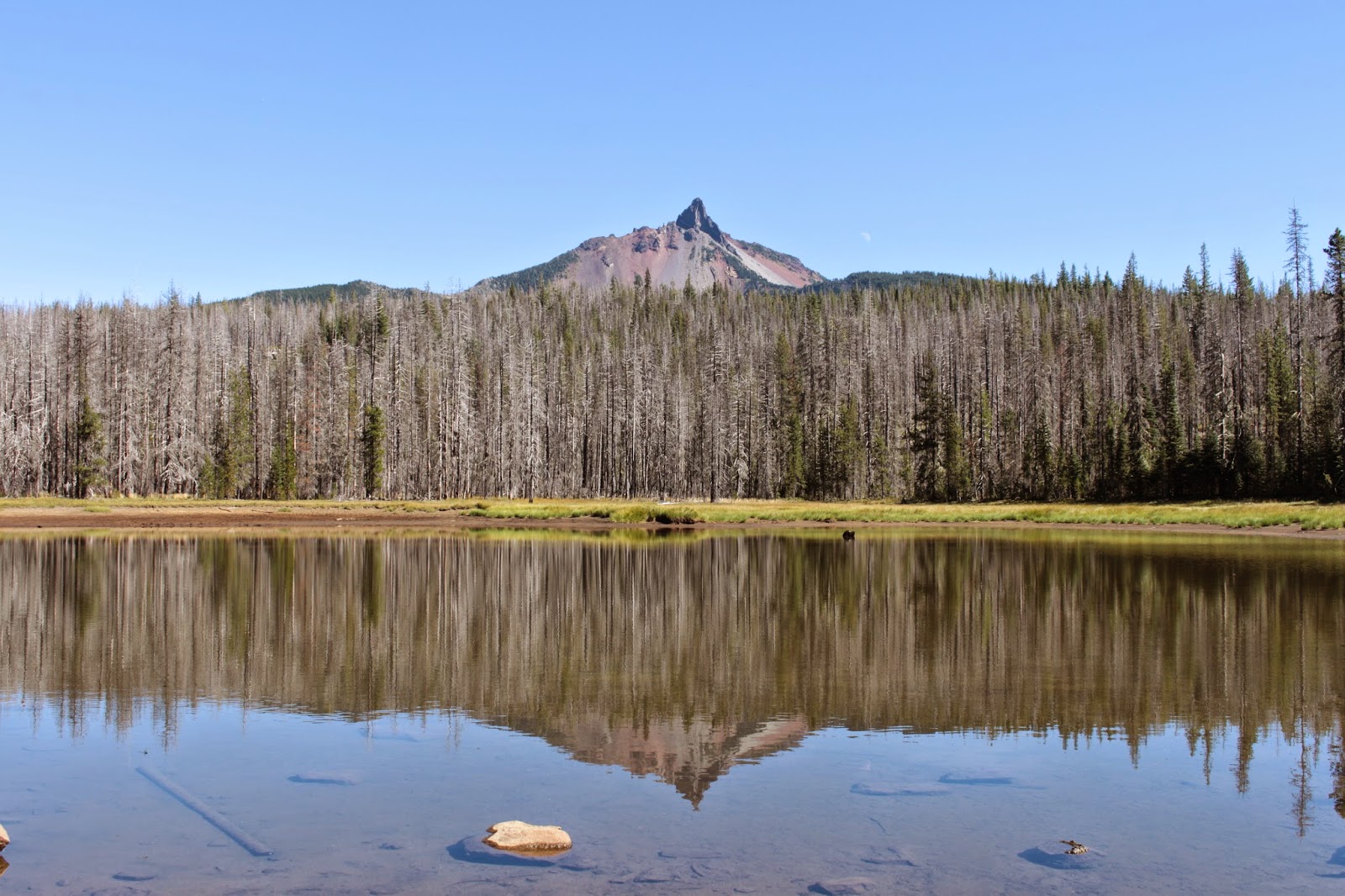
Fire has been a thing here before, and Suttle Lake is surrounded by a vast wasteland of dead and alabaster white tree trunks (also known as snags), a veritable tree graveyard left over from the 2003 B&B Fire. A young forest is taking root at the skeletal feet of their deceased ancestors and provide a close-to-the-ground green counterpoint to the colorless dead trees they are replacing. Over time, a number of the burned trees toppled (and still continue to topple) into the lake, and the branches made it appear like the partially submerged trees were swimming for their lives.

Woodsy trail along the shore

If you ignore that large lake thing on the left, then this trail might best be characterized as "woodsy". The pathway wove its way through trees that, because of their proximity to the lake, generally avoided the fiery death that their upslope brethren had to endure back in 2003. The trail was mostly level, although there were some small ups and downs along the way. A steady stream of hikers walking in the opposite direction exchanged friendly greetings with me before we each continued on with our respective journeys around the lake. Most of us would meet again on the southern shore as we completed our loops.

A watercolor painting by Mother Nature

The peaceful backwoods vibe came to a busy halt at the Link Creek boat ramp, frenetically bustling like a riled up ant's nest, but with picnickers and paddleboarders instead of ants. But that's alright, because a footbridge offered a nice view of Link Creek flowing into Suttle Lake. The creek was placid and unusually calm, like me on tranquilizers, and the surrounding woods reflected on the perfectly smooth creek surface, the reflections looking all the world like an abstract watercolor or an impressionist oil painting.

Bridgeway into darkness

You would think Link Creek got its name because it links Blue Lake to Suttle Lake. But a quick perusal of a topographical map shows that Link Creek also links Link Lake to Blue Lake and who knows where Link Lake got its name in the first place. Allegedly a trail runs from Suttle Lake to Scout Lake and Dark Lake. Sounded good, so I ducked onto the campground road with the intent of adding some more lakiness to this already lakey hike. However, after wandering lost through the braiding roads of the campground like a rat in a maze, I never did find any trail other than the one going around Suttle Lake. Hmm, I now have a mystery that needs solving.

A lone kayaker enjoys an outing on the lake

I'm not sure if this is a seasonal thing or because of the wind sweeping across the lake, but Suttle Lake was swarming with paddleboarders having a grand time in the sparkling lake. Kayakers also partook of the lake's delights, although they tended to paddle closer to shore. I found out that as slow as I walk, it's generally faster than a kayaker and I wrestled with the rare sensation of overtaking and passing as I walked.

The south shore was golden 

Once the west end of the lake was rounded, the trail went colorful with individual vine maple trees displaying their autumn foliage below the dark green of the surrounding firs. In the shade, the colors tended to be pale green or light yellow, but where the sun shone directly upon the leaves, it was the opening verse of a multi-volume sonnet about the oncoming colorful autumn season.

Yellow-veined hands grab at me as I hike by

Basically, all hiking progress came to a screeching halt on the south shore, thanks to the vibrant reds, yellows, and oranges flanking the trail. Many of the leaves were red, splotched with orange, with veins running yellow down their fingers as if they had bile for blood. Under the vine maple canopy, it then seemed as if the very air was suffused with color, like ambient sunlight on an alien planet. 

Lake Creek speeds by on its way to to the Metolius River

Link Creek enters Suttle Lake at the west end of the lake and Lake Creek leaves the same lake at the east end. The Suttle Lodge and resort were eminently visible on the other side of wide Lake Creek but unless you wanted to swim across (and I didn't) then there was still some hiking to do. The trail followed the creek to the paved road leading to the lodge and then the loop was closed off by hiking past the resort cabins before reaching the old stone and wood shelter at the trailhead. I did notice the Lake Creek Trail leaving the day use area, heading to the small community of Camp Sherman on the Metolius River. Hmm...call me intrigued although the chill wind has me thinking that'll have to wait till next year.

Every leaf a work of art unto itself

So, this was not the hardest or longest hike I've ever done, coming in at 4.3 miles with maybe 2.3 inches of elevation gain. But, it certainly was one of the most colorful and can only be the harbinger of a vibrant and beautiful autumn season.

Autumn is here!

For more photos of this hike, please visit the Flickr album.

Saturday, September 14, 2019

Square and Booth Lakes


The hike to Booth Lake was like Chapter Two of the Santiam Pass hike I had done a couple of weeks prior. Both routes begin from the Pacific Crest Trailhead, amble through the same fire-scarred scenery of the B&B Fire burn zone, and share many of the same views of the surrounding mountains and landscapes. Incorporating both routes, it is possible to do a 25'ish mile backpack loop by hiking past Square Lake, reclaiming the Pacific Crest Trail at Minto Pass, and then returning by way of the PCT to Santiam Pass. I ran into and spoke with various hiking parties doing the loop trip and it's now on my very lengthy list.


Buttes Hayrick and Hoodoo, to the south of Santiam Pass


I was on the PCT for only a quarter-mile or so before making a right turn onto the Old Summit Trail, which immediately beelined for Square Lake. Obviously, this trail does not get as much love as the PCT for the trail tread was rough and rocky in places, and also severely encroached by brushy vegetation exuberantly reclaiming the burn area. However, the views were predictably awesome with the spire of Mount Washington finger-poking the sky to the south, Beyond, were the Three Sisters and Broken Top while the perfectly symmetrical cone of Black Butte rose up in the haze to the east. Nearby, the flat-topped mesa of Hayrick Butte stood next to the ski resort of Hoodoo Butte.

Sadly and truly, this is a trail shot

Also encroaching the trail was a new forest of young trees as forest begins its unruly return to the Santiam Pass area. Here, the path inclined as it climbed up to a broad pass covered with young trees, chest-high brush, and ghostly white snags. The pass marks entry into the Mount Jefferson Wilderness, and there is a nice view of the rocky tower of Peak 5133 looming on a nearby ridgecrest as the trail began a descent down to Square Lake. By the way, since I also had a long and enjoyable look at Square Lake as I hiked past, I can honestly say Square Lake is indisputably round. There is a Round Lake nearby so maybe Square Lake is so named because Round Lake was already taken.

Square Lake, in the round

Square Lake is fairly large so it was a nice extended walk along the scenic lake, replete with surrounding snags and brush underneath a blue sky full of wispy clouds. There is a backpacking campsite on the north side of the lake and I exchanged friendly waves with a group camping there. But, after passing the lake, the trail began switchbacking to and fro up a rough and rocky slope rising ever upward in the open and exposed burn zone. 

View on the climb out of the Square Lake basin

As I slogged upward for next couple of miles, the tip of Three-Fingered Jack became more and more prominent on the north skyline. The going was slow because of the sustained uphill hiking on a day that was trending from warm to hot, making me wish Three-Fingered Jack would cast some cool shade in my direction. As elevation was gained though, the views improved and behind me, Square Lake became more distant but it was still an impressive big-picture vista of the blue lake pooling in a basin with high Cascades peaks rising beyond. 

Booth Lake sprawls below Three-Fingered Jack

At another pass with a stand of dead trees on top, the first view of Booth Lake presented itself. I called it good with the look at the lake, eschewing the descent down to the actual lake basin. While I admired the view, the camera was entertained by huckleberry bushes going autumnal red and by at least one fat toad surprised by my presence in his neighborhood. 

Attack of the killer orange fleshy caterpillars

Late season flowers such as pearly everlasting, miniature lupine, fleabane, and aster were doing their flowery thing and the asters seemed to be a favorite delicacy for some fleshy orange caterpillars spotted munching on the plant leaves. Some photography ensued, providing rest and temporary relief from an increasingly sore right ankle.

Pearly everlasting was one of the few flowering species still in bloom

I'd like to say I rolled my ankle or kicked away a charging bear or something totally awesome that would explain why my ankle decided to throb so agonizingly. But no, the ankle simply began screaming all of its own accord and for no obvious reason at all with about two miles left to go. So, it was a very slow walk back with lots of stops and ankle massages and some photography of fleshy orange caterpillars. Perseverance won out in the end though, and I did make it out to a two-week involuntary recuperation period filled with ice packs, Advil, and several chiropractic appointments to snap my ankle bones back into place. But, sore ankles aside, this hike was a fun one and almost worth temporarily sacrificing an ankle or two.

The texture of a sun-bleached and weathered snag

For more photos of this hike, please visit the Flickr album.


Sunday, August 25, 2019

Pacific Crest Trail (from Santiam Pass)


I like hiking in burn zones. It may be an acquired taste, but I find it fascinating to observe the process of a forest reestablishing itself after a fire. And, despite the tree carnage and scorched earth policy, there is also great beauty to be found in an old burn zone. Unfortunately, too much of a good thing can also be bad and if recent fire seasons are any kind of indicator, we all will have more than ample opportunity to learn to love burn zones in the near future. At any rate, the site of the B&B Fire at Santiam Pass still remains one of my favorite places to hike.

Beauty in a burn zone

At Santiam Pass, the fire began life as the Booth Fire in mid-August of 2003 while further to the north in the Mount Jefferson Wilderness, the Bear Butte Fire birthed into fiery existence. Eventually, the two fires joined forces as one and the two fire names melded together to become the B&B Fire. Even though the fire burned virtually in uninhabited wilderness, over $38 million dollars were spent to combat the fire. I'm not sure if the expenditure was worth the investment for when it was all over, the fire had consumed over 90,000 acres. Unfortunately, in our current era of megafires and gigafires, a 90,000 acre fire is just another small kilofire. 

Through-hikers hike through a new forest

The Pacific Crest Trail, at Santiam Pass, goes right through the old fire zone and while temperatures were hot down in our valleys, a chill wind up here kept things cool as I set foot on the famed PCT. Although the story of this hike was walking 10 miles through a forest of ghostly white snags, there is a veritable young forest forming on the ground and it won’t be long before the epic views encountered on this day will once again be blocked by flourishing trees.

The PCT angled up through a burned forest for mile after mile

The Pacific Crest Trail headed steadily uphill in the open sunlight and incessantly switched back and forth across an open slope as it worked its way up to the craggy slopes of Three-Fingered Jack. In places, beargrass covered virtually every square inch of available soil below the forest of dead trees, imbuing the rough terrain with a parklike vibe. Beargrass blooms every other year and when it’s beargrass time on this section of the PCT, the results must truly be spectacular.

Huckleberry bushes decided summer is over and done with

A few of the usual late-summer flowering suspects were putting on a subdued show, those suspects being most notably light purple daisy-like aster and fleabane, bright red skyrocket, and occasional yellow rabbitbrush flowers. We are getting close to autumn’s song and accordingly huckleberry bushes were blazing red in vegetative mimicry of the B&B Fire.

Sun-bleached snags against a cobalt sky

There are a couple of side trails leading down to the Berley Lakes or Square Lake but my order of business was the Pacific Crest Trail and I stayed on track when I arrived at those enticing trail junctions. The trail climbed at a consistent rate of ascent and a steady stream of PCT through-hikers passed me by. Ninety-six year old great-grandmothers may have also passed me by, because my pace was as slow as a lethargic turtle going up all those miles of inclined trail, but I'm blaming the views and camera.

What a view!

The views became more and more astounding as the trail gained elevation, thanks in part to the B&B Fire clearing out the view-blocking forest. Directly south of the trail was the pointy spire of rugged Mount Washington with the Three Sisters looming further beyond. Periodically, Three-Fingered Jack waved hello with one of its non-middle fingers showing above the ridge crest directly in front. To the east was the symmetrical cone of Black Butte with the vast central Oregon outback stretching out into the summer haze. The surrounding geology and geography were spread out like a large-scale three-dimensional atlas diorama, all covered with a fuzzy white layer of ghostly white snags, left courtesy of the B&B Fire.

Some of those surrounding lakes and scenery

There were plenty of lakes scattered in all the topology cited above and to the east, lakes Booth, Martin, and Square reposed in the basin sprawling west of Black Butte. There is supposed to be a cross-country way to leave the PCT and hike down to Martin Lake and return by way of the Square Lake Trail but the jump-off point was not obvious, so I stayed on the PCT like a good boy.

A rare section of green forest

At about the four-mile mark, the trail left the burn zone for a real honest-to-goodness green forest. Good thing too, for the chill breeze had long since failed to be and the day was getting to be quite warm out in the exposed and treeless fire zone. I ate lunch at a rocky viewpoint overlooking an expansive vista of Maxwell Butte and surrounding terrain extending into the McKenzie River drainage.

View to the Mount Washington and the Three Sisters 

After lunch, it was back the way I had come but the major difference was that I was walking downhill (and there was much rejoicing) instead of slogging up to some higher unseen place in my life. Also, instead of staring at the grassy parklike slopes inclining upward in front of me, I very much enjoyed a wide and expansive five-mile view of Mount Washington, the Three Sisters, and an entire county of dead trees under a blue sky. Simply beautiful, and the entire day confirmed my feelings about hiking in an old burn zone.

Path through spent beargrass and dead trees

For more photos of this hike, please visit the Flickr album.

Monday, September 1, 2014

Patjen Lakes

In 2011 the small Shadow Lake Fire started southeast of Mount Washington and little or no resources were devoted to the small fire until it swept over the Pacific Crest Trail (hereafter referred to as the PCT) and burned all the way to popular Big Lake. It was OK to burn the PCT because that only affects hikers and "Who cares about them?" (Says I, with just a hint of bitterness). However, when the fire threatened the large youth camp near Big Lake, considerable resources were quickly marshaled towards a more serious firefighting effort and the developed eastern shore of Big Lake was saved.

Degenerative tree disease
Because of several other fires in the Mount Washington Wilderness over the years, the wilderness today consists of pointy Mount Washington and acres of scorched earth and dead trees. There is probably not a single live tree in the whole wilderness. However, life bursts at the scorched seams despite all the death and destruction. Personally, I find that a burn zone has a special beauty all its own and I am not averse to hiking in one.

Waving plumes of dry beargrass
All this ashy rumination about forest fires came about because of a recent hike on the PCT in the Mount Washington Wilderness. There was ample opportunity to ponder the aesthetics of burnt forest near the Hoodoo Mountain ski resort on a hike in the Shadow Lake Fire zone. The hike would head south towards Mexico, although I would wind up just several thousand miles short of the southern terminus of the PCT. It was a game try, though.

Fireweed loves a good burn zone, too
As previously stated, life abounded. Fireweed, aster, common yarrow, and goldenrod were still blooming here and there along the trail. Because of the tree-killing fire, sun-loving bracken fern had laid claim to large patches of open forest floor. Bracket fungus, affectionately known as "conks", were slowly eating away at the dead and decaying trees. Sulphur butterflies congregated on the occasional damp spot on trail, sharing gossip as they licked wet soil. The trail was lined with dried plumes of beargrass flowers, long since gone to seed. Woodpeckers were everywhere making their woodpecker music and judging from the quantity of their tapping, the dead forest obviously is full of happy peckers. And more importantly, young trees were sprouting everywhere, fully engaged in the process of replenishing the burned forest.


Cause and effect
The original plan was to hike up the PCT and get as close to Mount Washington as possible via trail. However, an intersecting trail with a "Big Lake" sign called out to my inner hiking attention deficit and I wound up taking the right turn to see what the Big Lake shiny object was all about.


Well-used trail to Big Lake
The youth camp at Big Lake is an important resupply stop for PCT hikers making the 2,500 or so mile trek from Mexico to Canada. Signs with detailed instructions for hikers about picking up supplies and where to camp and when to shower greeted me at the camp trailhead. Apparently, they are glad to help the through-hikers as long as they are not seen, heard, or smelled.


Why we hike
A short walk through the camp brought me to the shore of Big Lake and there was a stupendous view to Hoodoo Mountain, Hayrick Butte, and Three Fingered Jack, all rising dramatically across the blue waters of the lake. The trail map showed a trail contouring around the lake to the intersection with the Patjen Lakes Trail but the burn interjected its ugly sooty head into things when the trail petered out  in a tangle of fallen trees and thorny brambles along the lake.

This plant has the gall
Not being familiar with the layout around this part of the Cascades, I backtracked and hiked back up to an unmarked intersection just short of the PCT. Several more unsigned and unmapped trail intersections left me more confused than usual, but a series of left turns kept me heading in the right direction as Big Lake was eventually left behind.

It burns us!
After rising gradually for a mile or so, the trail crested a ridge covered in dead trees and headed gently downhill. Mount Washington was actually fairly close but it was hard to get a good look at the pointy peak due to the millions of ghostly trees in the way. There were several patches of dead saplings bent over where they died, you could practically hear the trees scream as they writhed in indescribable agony.


Oh deer!
The ambiance improved considerably at the first of the Patjen Lakes. The lake was surrounded by a grassy meadow and Mount Washington reflected nicely in the lake's waters. A deer grazed in the meadow but it was keeping way too still and was making no attempt to steal my hiking poles. It was a decoy and I waded through the grass, clouds of grasshoppers flitting just ahead of me, for a closer look and photograph of the decoy.

Patjen Lake, without the laughing hyena sound
Returning back to the trail, a short walk brought me to the second lake where it was time for lunch. Across the lake was a woman who loudly laughed like a hyena at EVERYTHING her male friend said. Seeking a more peaceful outdoor experience, the first lake was revisited for a less noisy laze.


Eminently beautiful
There is a third Patjen Lake but the guidebook made it seem like it was more wet spot than lake so I called two out of three and headed back to the trailhead. It was a pleasant walk listening to the staccato tap-tap-tap of hammering woodpeckers and the soft sighing of the breeze sifting through dead branches as shadows lengthened in the afternoon. Despite all the fire carnage, the hike had been eminently beautiful.


The first Patjen Lake
For more pictures of this fire-addled hike, please visit the Flickr album, and don't play with matches and "Oh, the irony of that statement" says my mother.


Create Maps or search from 80 million at MapMyHike

Saturday, October 19, 2013

Iron Mountain

A friend of mine recently offered this solution for solving the next budget crisis and government shutdown: Lock up Congress in a room and until an agreement is reached, they can't leave except for food and bathroom breaks. I strongly disagreed with my friend:  Why give them food and bathroom breaks?

Iron Mountain's spire, from the summit
I offer the above paragraph to point out that the problem is not that members of Congress don't speak to each other to solve problems but that none of them are hikers. It's just too hard to not get along when hiking. In all my miles of trail, I have found hikers to be one of the friendliest bunch of people around. People of disparate backgrounds, different philosophies, and competing religions can all unite for the common goal: namely, reaching the car at the end of the trail and stopping for ice cream on the way home. Case in point was a recent hike to the summit of Iron Mountain by two people that can be as opposite as can be and I am referring to me and Mrs. O'Neill.

Scary things inhabit the woods
The full autumn show had passed us by but there were a few desultory yellow leaves as we started at the Tombstone Pass Trailhead. Tombstone Prairie was brown and dead due to the snows that had hit this area late September. The snow confused the vine maples and the leaves died on the vine, so to speak, and the dry brown leaves rustled with the slightest air current.

Autumn glory
After a short walk, we crossed busy Santiam Highway (look both ways before crossing, boys and girls) and the hike began in earnest on the Cone Peak Trail. "Up" was the operative word as the trail climbed almost 1,000 feet in just a little over 1.7 miles. No complaints yet as we were still pretty fresh and we enjoyed the shaded forest with the yellow and brown leaves in the understory.  The floor was carpeted with ankle-high thimbleberry, their leaves all glowing bright yellow.

Arrival at Cone Peak
Two miles into the hike, we took a respite from the uphill trudgery to admire views of Cone Peak and South Peak. The trail had left the forest and entered some lava barrens and the lack of trees led to the nice views under a deep blue sky. We also got our first glimpse of Iron Mountain with its distinctive pillar forever standing at respectful attention. We were trail-overlapping a family with two young girls around 5 and 8 years old. The kids were noisy with enthusiasm but on the plus side, we would not surprise any bears today. The parents are my candidates for Parents of the Year as they were taking the tykes on the full 7 mile loop, steep climbs and all.

Down into the murky woods
Leaving the slopes of Cone Peak, the trail then dropped down off a ridge and entered another shady forest which meant we had to climb out of the forest instead of staying on the level ridge. Why do trail designers hate their clients so? I think they should be locked in a room with no bathroom breaks or else be made to hike their own trails. But I digress.

How not to have a happy wife
So a brief climb took us around the shady side of Iron Mountain and then the fun started again. The side trip to the Iron Mountain summit was a seemingly interminable series of switchbacks up a treeless and rocky slope. It was about here we started to have our own budget crisis, hiking-wise. Fortunately, we averted a shutdown by making use of several stone benches conveniently sited at the switchbacks.  

That's it, I quit!
At a rocky viewpoint, Mrs. O'Neill lay down on the ground, her head dangling awkwardly as she was too tired to even remove her daypack. "That's it, I quit!" she stated ever so dramatically. "You go ahead to the summit, how far is it anyway?" I didn't bother to answer, pointing instead to the summit platform about 20 yards away. After a good laugh, she trudged the short distance to the summit.

Summit platform
The summit used to have a lookout on top but winds removed the structures several times so now we have a sturdily constructed viewing platform. A memorial plaque dedicated to Michael Robin, a lookout staffer who fell to his death in 1990, is a somber reminder about the danger of getting too close to the edge.  Nowadays, the summit platform is well railed to prevent another tragic accident.

The Three Sisters
The views were stupendous with the snowy Three Sisters rising to the southeast. Mount Jefferson was even closer, rising well above Crescent Mountain as it should, seeing how Jefferson is Oregon's second tallest peak. Mount Hood, 70 miles away, was clearly visible and amazingly beyond Hood was a ghostly white mound that could only be Mount Adams in southern Washington, a mere 128 miles away! Diamond Peak was brooding to the south and yet further south were the Crater Lake Rim peaks, faintly visible on the horizon.  To the west above the smoke filled valleys (it's wood stove season) was Mary's Peak, a Coast Range stalwart.  You really can see forever if you get high enough on a clear day.

Late afternoon
All good things come to an end and we picked our way carefully down the switchbacks and dropped back into the forest, descending into the Hackleman Creek drainage. As shadows lengthened, a short walk on the Santiam Wagon Road (now a trail) brought us full circle to our car. In a last cruel twist of fate, it was a very steep climb to the trailhead. I think Mrs. O'Neill wanted to lock both the trail designers and myself in a room with no bathroom breaks.


Uphill through the colors
For more pictures of this hike on a beautiful day, please visit the Flickr album.


Create Routes or find more routes in Sweet Home from millions at MapMyHike