Monday, February 18, 2013

Clearwater Falls

I've been having the urge to snowshoe lately but I happen to be a fairly fair-weather snowshoer. It's not so much the nasty weather as much as it is the driving in nasty weather. Apparently, my trepidation stems from my formative years in California and Mexico where the only time we saw snow was every four years when the winter Olympics were on TV. Anyway, on President's Day, a storm was coming in by late afternoon but that left the morning open for a short snowshoe trek to Clearwater Falls with John.

A curve, my kingdom for a curve!


Starting at a cut out in the snow banks flanking the North Umpqua Highway, we headed slightly downhill on the Trap Creek forest road which headed unflinchingly straight like a mosquito's path to a hiker. The road was uniformly flanked by snow draped trees with moss swaying in the branches. Snowshoe hare tracks criss-crossed the road interspersed with the tracks of a small predator, most likely a pine marten. An old ski track was the only sign that humans had visited, apparently we were just the second group of visitors to visit the area in the entire winter so far.

Snowshoe hare tracks
A mile later, we had yet to see even the slightest hint of a curve on the road. The road was uniformly flanked by snow draped trees with moss swaying in the branches. Snowshoe hare tracks criss-crossed the road....yup, there was a sameness to the scenery that was broken up after 1.5 miles when we arrived at the Clearwater Falls Campground.


Chewy picnic table in the middle
We strolled into the campground which was vacant, no reservations were needed this weekend. The campsites were only distinguishable by the round mounds that contained a picnic table in the snowy center, in a frozen woody version of the candy kernel at the core of an Easter Bunny chocolate. Maybe the Easter Bunny is really a snowshoe hare, but I digress.


Clearwater River
The Clearwater River runs by the campsites and on this winter day, the scene was delightfully pastoral. The river was placid, streaming tranquilly through a myriad of snow-rimed logs strewn about like spilled toothpicks across the slow current. Much gawking and content appreciation ensued, the river view was well worth the walk.


Jump, John, jump
Because we had more tamales to roll, so to speak, we continued on the road a short bit where we could hear but not see the falls. It was time for all good snowshoers to leave the road and go cross country down a snowy and forested slope to the Clearwater River which was running a bit faster down here.


It's a Richard Hike!
Just as we were pondering how to cross the river we came across a very narrow and unrailed footbrige with a slab of snow cake, the slab being several feet high. The river coursed under the bridge, eagerly anticipating the delivery of a snowshoer; my first thought (sanitized and reworded for publication) on seeing the bridge was something along the lines of "Oh golly, that looks a wee bit chancy!"

Viewing area, without the summer tourists
Now we could debate the stupidity or safety of crossing the bridge all day, but we didn't and we found ourselves happily dry-footed on the opposite side of the river. A short (and much safer) walk brought us to Clearwater Falls viewing platform and another round of gawking.

Clearwater Falls
The geology around here is lava based and is quite porous.  Clearwater River runs mostly underground before popping out in a meadow about a mile away from where we stood. So, when the river careens over a rocky ledge, much of the underground flow also has to tumble down as well. The net effect, visually, is it looks like the cliff leaks water like tears leak from a granddaughter whose  favorite balloon just popped. 

Snow storm was coming in
We worked our way as close to the falls as was possible in clumsy snowshoes and eventually headed back to our car. We actually continued on past the car for a little additional mileage as we had not walked very far. We found the road to be unerringly straight, flanked by forest, moss in the trees, with hare tracks underneath....etc.

For more pictures of this wintry trip, see the Flickr photo album

Saturday, February 16, 2013

Dellenback Dunes (again!)


Just a month prior, I took grandchildren Aiden and Coral Rae for a short 3 mile hike on Dellenback Dunes. While we enjoyed the experience, the fact remains that the expansive dunes just beg for more exploration than can be experienced in a three mile hike. So, when the Friends of the Umpqua Hiking Club penciled in a hike on the Dellenback Dunes, it was time to put on the man-boots for a serious hike in the dunes. Dollie and 9 year-old Aiden came along too, so maybe it would not be all that serious.

Hiker ant line
Rain was in the forecast for the afternoon and as we started, clouds were hanging around the dunes here and there in preparation for the afternoon rain festivities. The sun was out also, and the combination of clouds, blue sky, and warm sun was extremely camera friendly and it wasn't long before I found myself lagging behind the group, the only sound on the quiet dunes being the click-click-click of my camera shutter.

Whee!
Halfway down the "Great Dune", John (the hike leader) took a right turn and headed north, away from the main dune. Dropping steeply off the dune crest, we bottomed out on a sandy trough with ponds before heading steeply up the next dune. You see, the dunes tend to run east-west and since we were heading north, the hike quickly became a trailless up-and-down hike as we crossed tall dunes in soft sand.

Unclear on the concept of walking
There was a prominent tree island ahead and I assumed we would head to the beach after rounding the island. After working our way (we were walking at wife, boy, and photographer speed) up the steep tree island, a huge series of dunes rose ahead of us. Actually, dune is too kind of a word. These dunes were more like the Cascade Mountains of sand with the troughs in between being more like the Grand Canyon of sand. Actually, after climbing up and out of the valleys, it was more like Hells Canyon of sand. And, much to our dismay, we could see our people far ahead climbing up the tallest one, looking like the ant line on my kitchen counter. It was about then we began to refer to John as Sir John the Cruel.

Dramatic scene
But if you are going to have burning leg muscles, you might as well have them in a beautiful place like Dellenback Dunes. The clouds were the story of this hike.  Big black, white, and gray clouds hovered dramatically over the sand mountains and canyons while sun warmed tired hikers. Lots of pictures were taken of the incredible cloud scenery while hiking up steep sand hills. 

No running boy on this one
Aiden had been running up the dunes, as is his wont. However, a veritable wall of sand rose up, nearly vertical, and there would be no running up that. The tracks of the club angled upward across the face of the wall through a leafless willow thicket and my legs ached in anticipatory pain just looking out our route. Trudging up slowly but surely, we traversed up and over the massive dune crest and I noticed Aiden was done running up dunes after that. 

Feeling froggy at lunch
The good news was that this was our last big uphill sand walk; it was now a gentle downhill and we made a left turn towards the now visible ocean. In between the ocean and our hiking party was the deflation plain forest (which was full of standing water) and we could not find a way to get through the dense brush to the ocean. Improvising, we walked south, parallel to the forest's edge and sat down in a small clearing for lunch. Aiden, in activity totally unrelated to eating lunch, explored the swamps and caught a number of frogs. At least, I hope the frog catching was totally unrelated to eating lunch.

Walking next to the marshes
After lunch, we continued south to the bonafide trail leading from the dunes to the beach. Aiden was back to his old tricks, running ahead of his slower grandparents. At the trail junction, hardy hikers turned right for a longer hike to the beach while the short-distance hikers and wife turned left for a return to the car. Aiden was to return with Dollie but he instead went to the beach so I had to follow and retrieve him.

Feet got wet on this hike
The trail through the forest was very swampy and it was impossible to keep feet dry. It was like a Richard Hike without all the responsibility. As we neared the beach, an elevated boardwalk kept wet feet from getting any wetter in a case of "too little, too late".

Aiden explores the beach
At the beach, clouds came in and it looked like and felt like rain was coming in. We hung out for a bit and some of our group doffed shoes and went for an ocean wade. That was an open invitation for a 9 year-old boy and he joined the waders. After a bit, everyone left except for a boy who took forever to tie his shoes, much to the consternation of his impatient grandfather.
The beauty was lost on Aiden, at this point
We figured Aiden's maximum hiking distance was about 5 miles or so and we were well above that with the beach detour. So the next three miles or so were spent cajoling, yelling, and enticing a very tired Aiden to keep his feet moving. It was a big hike for a small boy. After it was all over, he wound up eating a promised hamburger after a tough 7.6 miles.

Our route

For more pictures of this hike, please visit the Flickr album, the scenery was fantastic.


Saturday, February 9, 2013

Pizza Connection Trail

" I don't like to snowshoe,"  said Dollie " they make me feel like I'm waddling". Sigh, an opening for so many jokes best left untold in interest of marital harmony. So in concession to a reluctant wife, the groomed and flat (read "easy") Pizza Connection Trail would be the snow hike of choice.


Me and a hiking buddy
In winter, Diamond Lake freezes over and becomes primarily a playground for the snowmobile crowd. Throwing skiers a snowy bone, the groomed road through the summer campground is designated as a cross country ski route. Running from the Diamond Lake Lodge to the pizza parlor on the southeast corner of the lake, the manicured road has been dubbed the Pizza Connection Trail. The restaurant is accessible only by snowmobile (on their own road, apart from the ski trail), by ski, or by snowshoe (the poor step-relative to cross country skiing). Pizza and a heated restaurant interior is the reward for intrepid skiers and 'shoers.

Ice fishing on Diamond Lake
Beginning at the boat ramp parking lot, we set off alongside the east shore of frozen Diamond Lake. Gone were the sparkling blue waters of the lake, replaced instead by an expanse of white ice. Like ants on a wedding cake, ice fishermen dotted the snow-covered ice.

My view for 5.5 miles
A low cloud cover hung over the lake and Mount Bailey played coy with snowshoeing photographers, the mountain never quite making a complete appearance over the frozen lake. As we walked, the cloud cover became thinner and thinner just like underwear over time, and before long, we had blue skies, white snow, and a sunny day. However, the sunlight was as weak as a bowl of watery gruel and temperatures remained well below freezing.

All that can be seen of a drinking fountain
The campgrounds were covered with snow and the only indication we were even walking through a campground were the tips of drinking fountains poking up out of the snow or an occasional mound of snow that was barely recognizable as a picnic table. Snowshoe hare tracks crisscrossed the trail but we never saw any as the noisy crunch of our snowshoes warned them well in advance of our arrival.

A word from our sponsor
After nearly 3 miles of steady walking on the groomed trail, we arrived at the pizza restaurant and the sweet odor of pizza was entrancing. However, Dollie was not hungry so I had to make do with sniffing the aroma over a rumbling stomach. Trail mix is a poor substitute for pizza.

Mount Bailey
We walked out onto Diamond Lake for a better view of the large frozen expanse of the lake. Mount Bailey was nearly visible in its entirety and we could see the craggy peaks on Crater Lake's rim.

The sound you hear is my teeth chattering
On the way back, an arctic breeze kicked in and dark clouds covered up the scenery, sucking the warmth and light out of the air like a surprise visit from a parole officer. We picked up our pace, eager to beat the impending storm. I'm glad to report that no wives were frozen in the hiking of this hike and a good time was had by all.

For more pictures of this trail, please visit the Flickr album.


Saturday, February 2, 2013

Riverview Trail (loop version)

The Riverview Trail is one of those winter standby hikes. The scenery is fairly mundane and unimpressive and normally I wouldn't ever hike on it. On the plus side, the trail is wide (being the North Umpqua Highway in a former incarnation), the tread is smooth and even, and the trail is blessedly snow-free most of the year. Ergo, when snow keeps hikers out of the mountains, the good old Riverview Trail reliably fills in for unappreciative hikers.

The Riverview Trail
The Friends of the Umpqua Hiking Club normally jazz up this hike by hiking straight through and putting out at Fall Creek Falls, shuttling drivers back to the trailhead afterwards. Being in the mood for a longer hike than the 8 miles to the falls, I set up a loop which involved a walk along the North Umpqua Highway and a return on the Mott Segment of the North Umpqua Trail for a nice little 11.7 mile round trip hike.

A chilly start to the hike
The sun was sort of out with some clouds taking issue to the sunshine; it still was pretty chilly, though. It was cosmetic sunshine: it looked nice but lacked the warmth necessary to induce hikers to offer their winter-white legs in grateful tribute to the sun gods. Jackets, vests, beanies, and gloves remained firmly attached to hikers despite the exertion of the walk.

Williams Creek


The Riverview Trail quickly climbs above the North Umpqua River (and highway) before leveling off with limited views of the river peeking through the trees. We were on the north side of the river and sunlight slanted poetically through the forest. At the two mile mark, we crossed over the Williams Creek footbridge. Because of the good condition of the trail, I was making quick time and before long, it was time for me to leave the Riverview Trail and head downhill to the Bogus Creek Campground.


Bogus, dude
I just had to say "Bogus Creek, dude" in my best California surfer accent before exiting the campground and crossing the North Umpqua Highway. A mile long walk along the unusually quiet highway brought me to the Wright Creek Bridge and a crossing of the North Umpqua River. The return back to my car would be along the Mott Segment of the North Umpqua Trail.


Wintertime color
The North Umpqua Trail was narrow, rocky, muddy, and I had to wade through encroaching vegetation. Ah, so good to be on a real trail again! Being on the shadier side of the river, the forest was a dripping and gooey biomass of ferns, moss, mushrooms, and rushing creeks. And always, below the trail coursed the strikingly turquoise colored waters of the North Umpqua River.


Hefty cascade on the North Umpqua
Just past the impressive cascades near Steamboat Inn, I could see the bridge crossing of Steamboat Creek across the river. My car was parked there and it seemed cruel that I had to hike nearly two more miles to return to my car, but that's hiking life for you. The only way to get across the river, short of swimming, was to hike upstream to the historic and picturesque Mott Bridge.

...speaking of hefty
Jennifer, Edwin, and Merle had all agreed to hike the longer loop with me but I had not seen them since we started hiking. Determined to catch up to them I walked at a pretty good clip. Turned out, they had missed the Bogus Creek turnoff and had to backtrack. They too were walking fast, in an attempt to catch up to me.  With all of us trying to catch up to each other, we naturally never made contact until the end of the hike. They stated they'd "...figured we'd catch up to you at some point".  I think I was just called slow.

For more pictures of this hike, please visit the Flickr album.

Monday, January 21, 2013

Crater Lake

Crater Lake sits in our backyard, so to speak, and happens to be one of my favorite playgrounds. However, visiting the lake in summertime is kind of a mixed bag.  The lake is outstanding but there are hordes of visitors and not all of them belong in the great outdoors. I remember seeing a paunchy man leaning way over a parapet to hand-feed a peanut to a ground squirrel, totally unaware of the sharp teeth and claws that a ground squirrel can wield or the broken bones that gravity can inflict on a roll down to the actual lake part of Crater Lake. I remember thinking "City slicker", with a heavy sigh.

The west side of Crater Lake
Another time, Dollie and I camped at the lake in early July and the lake was covered by clouds: clouds of mosquitoes, that is. The campground store was selling bottles of insect repellent at something nearing the price of gold; their supply ran out in minutes, even at the exorbitant prices. People of all countries were slapping their faces and hands while hurling multilingual invective at the invertebrate vampires.

At least they don't drink your blood
Ah, but winter is really the best time to visit the lake. Visitors are few and far between, while the lake and environs are cloaked in picturesque snow, and a profound hush envelopes the park. Pick a sunny winter day and it's a whole new level of wow factor. And best of all, there are no mosquitoes.


Snowshoe rookie


John had never been snowshoeing before and there is really only one place to go for your first showshoe trip; prescient readers will divine that the place to go is Crater Lake. Maybe the title of this blog entry gave it away. The views will astound, the trail is fairly flat, and the snow on the west side is usually firm, and snowshoeing first-timers will be suitably impressed.


Summer, in Oregon
We started the walk mid-morning at the Rim Village and the temperature was 11 degrees, a perfect temperature for snowshoers and an abomination for Floridians. The sun was out and the day would warm up to the 50's, various clothing layers were soon shed and stowed away in our packs. I would have worn shorts but my legs are whiter than the snow this deep into winter.


Rim Drive was our trail
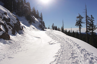
The "trail" was simply Rim Drive, totally devoid of smoke belching buses and tourists, some of which are also smoke belchers. The roadway's course was always eminently visible as it carved a wide and white (just like me!) swath through the forest. And if there was ever any doubt, the path of churned up snow due to skiers and 'shoers made the trail obvious and easy to follow.

Mount Scott, across the lake
The basic pattern was to hike to a lake overlook, ooh and ahh for a bit, and then meander through forest and snowy plain, then return to the lake again. We enjoyed views of all the peaks on the lake's rim, Wizard Island, and the lake itself. Despite the relative heat wave, a thin sheet of ice covered the lake's surface.


Hello, Mount McLaughlin
To the west lay the rounded peaks of the Rogue-Umpqua Divide, to the south we could see the symmetrical cone of Mount McLaughlin and the jagged spire that is Union Peak. We could also see the tip of Mount Shasta, a mere 100 miles away. On a clear day in crystalline winter air, you can seemingly see forever.


The Watchman


We had a vain notion to climb to the summit of The Watchman but the notion seemed more daunting the closer we got to the formidable mountain. From far away, it seemed like a casual walk up a gentle slope. Up close, the "gentle" slope was more like The Great Wall of Watchman. John took a test run up a nearby hill and quickly disavowed himself of the idea of walking up a steep slope in soft snow.


Wizard Island


So back we went towards Rim Village and we got to enjoy the views all over again in the afternoon glow with lengthening shadows. John enjoyed his first snowshoe experience and stated he'd like to do another snowshoe hike. Mission accomplished, in my book.

For more pictures of this awesome place, see the Flickr album.


Saturday, January 19, 2013

Seven Devils Wayside to Bullards Beach

The Friends of the Umpqua Hiking Club had a scheduled hike from Seven Devils Wayside to Fivemile Point several weeks ago. However, it looked like it was going to be a short hike so, naturally, I began to plot a way to jazz it up. I toyed with the idea of putting on a backpack and making a weekend out of walking to Bandon and back but the weather was not all that nice and I really didn't feel like camping in the cold fog. But, hey, I can day hike in cold fog so a shuttle hike was planned for the 9'ish mile beach walk from Seven Devils to Bullards Beach, near Bandon.

If you like the color gray, then this is your hike
Joined by the usual suspects (John, Edwin, and Merle) we bid adieu to our fellow hikers who were heading north while we set off to the south in heavy fog. The weather forecast had called for a sunny day once the fog burned off but as it turned out, we would never see the sun during the hike. Too bad, because the long winter leaves me pale white like one of those blind cave salamanders that scurry away when a flashlight shines upon them.  I could really use some sun.

Fivemile Point rocks!
A short walk to the south brought us to the only obstacle we would encounter on the day: Fivemile Point. The hike leader had admonished us to be careful, citing dangerous sneaker waves from Japan. However, the sneaker waves were so sneaky we never saw them and we enjoyed a wide beach at low tide all day long. There was a greater likelihood of Beyonce not lip-synching at a presidential inauguration than there was of our being swept away by a Japanese sneaker wave.

It's a Richard Hike!
However, the tide had not finished receding when we hit Fivemile Point and we had to scramble over the mollusk encrusted rocks to get around the point. We quickly learned gray rocks were good, black rocks were bad in nature's color coding system for hiking safety. The black on the rocks was seaweed and algae and slipperier than a booger on cold concrete. Sad to say, barnacles were harmed on the crossing of the point but at least we hikers remained hale and hearty.

I don't know, Tiger, my ball just disappeared
Once around the point, miles and miles of empty beach stretched ahead of us although we couldn't see most of it due to the fog and cloud cover. Bandon Dunes, a local golf course, was on top of the shoreline cliffs and it was common for us to find golf balls in the beach debris.  


Cut Creek awaits Edwin
Edwin's going down


On the way to Bullards Beach, there were two large creeks to cross: Whisky Run and Cut Creek. Edwin leaped across Cut Creek and just as I snapped a shot of his landing he toppled over and fell with a thud. Fortunately, that was the only mishap of the day and he was bemused, muddy, but unhurt.

Bullards Beach is a rockhound's delight
About 7 miles into the walk, the sand became stony and we began to encounter other beachgoers searching for agates and other treasure in a sure sign we were nearing Bullards Beach. Edwin found a fossilized clam, I found a couple of nice chunks of petrified wood, and John found a half-dozen more golf balls.


Welcome to Chateau Bullard, accent on the "ard"
On Bullards Beach, ocean currents deposit a lot of driftwood and some enterprising soul had built what could only be described as an architectural structure for a windbreak. We paused in admiration of the engineering involved in the construction, it really was a pretty elaborate endeavor as far as beach windbreaks go.


The Coquille River Lighthouse
Not long after, the Coquille River breakwater and lighthouse came into view, signaling our hike was over. Chilled, we stopped on the way home at the Coquille Produce and Deli for some Texas burritos.  Let's just say that after two bites we were no longer chilled. We couldn't feel our tongues either and taste buds were permanently scalded into oblivion by the hottest hot sauce this side of the Pecos River. I think those burritos were more dangerous than the Japanese sneaker waves.

For more pictures of this gray hike, visit the Flickr album.