Saturday, November 9, 2019

Cape Blanco (via Sullivan Gulch)


Cape Blanco State Park is one of my favorite places to hike at. To nit-pick a bit though, there's a sameness to the trail network in that all possible routes essentially follow the coast from the Sixes River to the Elk River or vice versa. Yes, you can hike either atop the forested coastal bluffs or on the beach but either way, you are pretty much hiking from the Sixes River to the Elk River or vice versa. But as I recently found out, there is an inland approach that begins at Sullivan Gulch. Yay, somewhere I'd never hiked before, and naturally, the alluring "new trail" siren song called out to me. Powerless to resist its haunting melody, I soon found myself lacing boots at the cattle gate that serves as the Sullivan Gulch trailhead.

For some reason, we did not take this trail, not really sure why that was

Accompanied by my trusty sidekick Lane, I opened the cattle gate and our hiking festivities commenced with a walk up a grassy ranch road flanking the west side of Sullivan Gulch. Per the Oxford English Dictionary, "gulch" is defined as a "narrow and steep-sided ravine marking the course of a fast stream". Well, Sullivan Gulch is not narrow, nor is it what I would call a ravine, and good luck finding a fast stream in the marshy wetlands. The wide swale with plenty of standing water in it does have steep sides though, but the trail here sort of cheats past by finding a gap in the steep sides on its way to the beach.
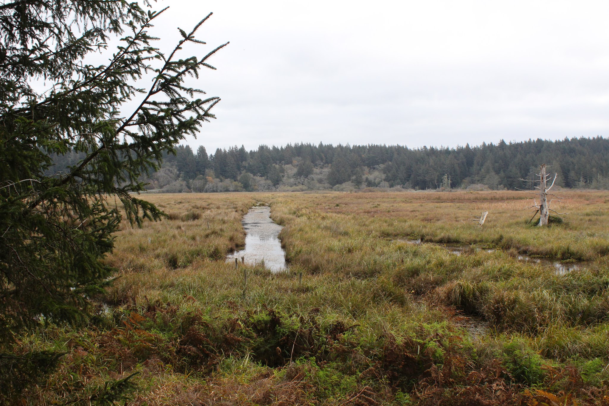

Waterway in the Sullivan Gulch wetlands

The first part of the route followed the wide grassy marsh containing ponds, drainage ditches, and various other forms of standing water in and among the marsh grasses. Ducks make a home in the ponds and regrettably, our arrival caused them to flee their watery abode in quacking panic. A more intimate exploration of the gulch was effectively discouraged by wire fencing and standing water, so we just looked and did not touch.

Mother and child, toxic mushroom style

It didn't take long for both of us to decide we really like this trail. The path gradually left the edge of the marsh and we hiked in woods sublime. White-trunked alder trees were already leafless, proffering their bony limbs to the sky in supplication for the return of leaves purloined by winter's arrival. Closer to ground level, the greenery was still thriving, unwilling to surrender their leaves like weak-willed alders. Ferns draped over the trail and mushrooms were everywhere. This was too much to expect two dudes with cameras to walk through without engaging in much photography. Consequently, it was slow going through the woods to an overlook of the beach from atop a tall dune.

Bushwhacking is fun!

Before we hit the beach though, we followed an obvious path leading into the forest, curious to see where it went. 
As it turned out, it pretty much went nowhere. The well-defined path quickly degenerated into a loose network of deer paths, game trails, and thick forest clawing at us as we fought our way up a ridge. Eventually, we wound up at the edge of Sullivan Gulch, wrestling head-high grasses while mud sucked at our boots. While fun, the bushwhack venture yielded little reward, so we bushwhacked back to the sandy saddle above the beach.

The mighty Elk River

The tide was out and the exposed wet sand was hard-packed (just like my abs, hah!) and perfect for hiking on. We beach-walked south for about a mile before the swiftly moving Elk River barred further progress south. Surprisingly, the fairly remote river was in use by a moderate population of salmon fishermen. After an obligatory lunch and laze next to the river, Lane and I returned to the overlook atop the dunes.

A sea of silver mercury

Feeling adventuresome and walky, always a potent situation, we grabbed a footpath that headed straight up through some woods. The whole vibe of this section of trail felt like wilderness because we did not see a single soul as we trudged upward. The trail served up some expansive views of Sullivan Gulch and the beach south of Cape Blanco as our route zigged and zagged from the ridge crest to the east side and then back again. After a mile or so of this, the path crested at what presumably is the tallest point in the park.

Flocks of geese head north

Oh, the things we could see from the top! The beach lay immediately below our clifftop perch, albeit several hundred feet below. Fishermen and beachgoers looked like ants on a kitchen counter and their vehicles like little Matchbox toys waiting to be picked up by a giant hand. Offshore loomed the ocean, glinting silver in sunlight diffused by an indistinct cloud layer. Ah, now this is why we hike!

Lane and Richard go for a hike

After admiring the view from our clifftop aerie, it almost seemed anticlimactic to cut across the horse camp and take the trail back to Sullivan Gulch. However, the forest was lush and green and the trail challenged our legs as it dropped straight down into the gulch. I do mean straight down, for the trail plunged as fast as a wingless duck, putting our quad and glute muscles to the test as we bravely resisted the pull of gravity on the way down. Once back down to gulch-level, the hike was finished off with a short walk on a grassy path covered with crawling newts. I think this is my new favorite hike at Cape Blanco State Park.

They say the spirit of Sullivan still haunts the park

For more photos of this hike,
please visit the Flickr album.


Saturday, November 2, 2019

North Umpqua Trail (Jessie Wright Segment)


Well, things were certainly a bit chilly on this early November morn! Jackets, ski caps, and mittens were items de rigeur down at the bottom of the North Umpqua River canyon, unless you're partial to frostbite. Things weren't always this cold, though. In the summer of 2017, part of the Umpqua Complex Fire(s) raged on the Jessie Wright Segment of the North Umpqua Trail (NUT) and the fire scars were visible throughout the hike. While we could have certainly done without the destructive wildfire, to be honest I wouldn't have minded rubbing hands together over a still-smoldering ember or two.

Lots of jackets, gloves, and ski caps on this crew

Fifteen humans and one dog commenced this hike with a short walk along the North Umpqua Highway. Since the trailhead parking is at the Marsters Segment trailhead, we had to cross the river on the roadway to get to the Jessie Wright trailhead. Upon setting feet on a real trail, the scars from the fire were immediately apparent. The fire here had been somewhat beneficial for although it killed the saplings, the older trees survived, proudly sporting scorch marks upon their trunks as a battle scar. In essence, the fire just cleared out the undergrowth, an aspect of wildfire that is actually good for forest health, although the slain saplings might object to that characterization.

A cold river of cold water on a cold morn

We all hiked pretty quick, for the the season was in that cold little space between fall and winter, but the exercise warmed bodies, minds, and souls. The sun was out and the sky was clear but unfortunately for us, the sunlight did not reach the bottom of the cold river canyon. The grasses and leaves close to the ground were dusted with a light coating of frost and the air was cold and nippy. But while the weather was wintry in some aspects, autumn still had a thing or two to say about that.

We hiked through fireweed patches that were dying off

The fall season was well represented by red and yellow leaves still hanging on the maple and dogwood trees. The first frosts of year had signalled to the bracken ferns on the ground that they too had to turn yellow and they so obliged. Dense patches of fireweed, already gone to seed, were beginning the winter shutdown process by browning out and dying off. Below the trail coursed the North Umpqua River, the waters looking black and cold as an ice queen's heart and definitely not tempting hikers in for a quick dip.

Mushrooms huddle together to keep warm

Mushrooms and fungi thrive in a post-burn zone because the dead trees provide ample food for fungi family members; it's like a decade-long all-you-can-eat feeding frenzy. Normally, the fungi organism is just a threadlike root existing underground until it's time to further the species by the process of reproduction. The mushroom or fungus that we observe above ground or on a tree is the reproductive organ, so to speak. In our area, it seems the peak breeding season for fungi is in November and accordingly, we observed all manner of fungi figuratively going at it on logs, fallen trees, standing snags, and on the mossy ground.

Trees both live and dead, post-fire

The trail climbed up to a point high above the river and stayed there as morning headed into afternoon. By the time we reached our turnaround point at Boulder Creek, the sun was rising over the tall ridges flanking the river and our hearts were gladdened while our bodies were warmed by the glorious light. It was nearly an anti-winter political statement when we defiantly shed outer layers and basked in the noonday sunlight. Begone, o tyranny of wintry chill, don't frost on me!

A dogwood basks in the warm sunlight

Jay and I soon lagged behind, our progress happily slow as we photographically enjoyed the autumn day now that sunlight reached our side of the river. The forest was by now bathed in afternoon light with lengthening shadows slanting through the trees. Sunbeams were hijacked and appropriated by vine maples sticking branches and leaves into the light, like somebody warming their hands over a smoldering ember. 

The North Umpqua River on a chill autumn day

In the morning leg of this hike, the river had a cold and forbidding appearance, running black in the absence of sunlight. But in the afternoon sunlight, the river was now colored dark green with white-watered rapids running bright and white. The sun also lit up what leaves remained with the big-leaf maples trending to yellow, the dogwoods to red, and the vine maples every available color from the warm end of the spectrum. The trail and forest were eminently beautiful, particularly coming as it did, after a wintry morning.

C'mon sun, you can do it if you try!

Poor Jay. He hails from Gujurat, India where the winter temperature might get down as low as 70 degrees. And here we were, hiking in the mid-40's, one of us clad in shorts and a T-shirt, the other clad in a parka, ear muffs, muffler, scarf, mittens, and battery-powered warming socks. Just about when he was beginning to question his moving to Oregon and becoming friends with me, we reached the trailhead and the car heater restored his happy good nature. It would be another three months before I could persuade him to go hiking with me again.

Dogwood colorizes the forest

For more photos of this hike, please visit the Flickr album.


Saturday, October 19, 2019

North Umpqua Trail (Hot Springs Segment)


The year before, I had hiked on the Hot Springs Segment of the famed North Umpqua Trail (NUT) and the fall colors were astounding. So vibrant, so colorful, so eminently autumnal, I just had to come back and show my friends what a great fall hike the Hot Springs Segment of the NUT was. Chalk it up to the Richard Hike effect, but naturally on the day of this edition of the Hot Springs Segment hike, it just would have to be a gloomy, gray, and all-around dreary day dumping cold rain on my autumn hike dreams, hopes, and aspirations. It also stood to reason that when the weather gets bad, three people will nonetheless show up for the hike, preventing me from canceling the hike and spending the day indoors, all cozy warm and comfy dry. Props to Lindsay, Tim, and Patti though, for forcing me to "enjoy" a wet and rainy hike in a sodden but colorful forest. 

They don't look very happy to be rain hiking

Beginning at Toketee Campground, we crossed the North Umpqua River on a gracefully arching footbridge and traipsed up and down through a dark but lush forest. The rain was coming down fairly heavy and Oregon grape leaves, fern fronds, and hiker heads all glistened from the accumulated wetness. Autumn was in full song, albeit on the soggy side, and the trail was covered with leaf litter. I always enjoy the swishing sound of boots scuffing through leaves, but that's a sound which does not get made when the leaves are waterlogged.

A beautiful trail on a not so beautiful day

It's hard to pick a best section of the North Umpqua Trail's seventy-eight miles, but the segment after the trail drops down to river level would be a prime candidate. The path is covered by a leafy bower of yellow leaves with colorful forest on one side and swiftly flowing river on the other. When not meandering through dense stands of vine maples, the track weaves through a cathedral-like aisle of tall firs. And always, fallen leaves covered the trail, having been knocked down to the ground en masse by the unrelenting rain. Despite the moisture falling from the sky, much photography ensued, along with muttered apologies to my camera.

The North Umpqua flows through the autumnal woods

Just under the two-mile mark, the North Umpqua Trail popped out onto gravel Forest Road 3401 heading towards Umpqua Hot Springs. Driving there is cheating in my humble opinion, the hot springs should only be enjoyed after a good long hike to get there. Although to be honest, driving to the steamy springs would make more sense on a cold and rainy day, but that's not how we roll. At any rate, we crossed over to the opposite side of the river via road and bridge and resumed hiking.

Decaying leaves make a bridge crossing treacherous

After crossing the rushing river, the trail acquired more of an uphill quality as it began to gain some elevation. However, the rate of acquisition was not all that steep, and it was fairly easy walking except for the rain falling from the sky, imparting the forest with a surround-sound hiss of raindrops striking dead leaves. At about the three mile mark, the stout metal bridge at Deer Creek hove into view and given the wet conditions, it seemed like a good place as any to turn around at.

The forest was full of mushrooms, big and small

After a quick look-see at Deer Creek flowing under the bridge, we headed back and thankfully, the rain began to ease up. The Tim and Richard half of our crew had cameras and per the natural order of things, we soon were bringing up the rear. And can you blame us? Mushrooms and fungi were sprouting everywhere in the damp forest, in all manner of shape, size, and color. And where there were no fungal delights to entertain us, there was an ample amount of fall color thanks to the maple and dogwood trees.

The Golden Road

Since this was an out-and-back hike, we enjoyed the same old beautiful forest and river scenery all over again, the main difference being that we were comfortably dry and generally unrained upon on the return. While dry, we were not necessarily warm as the sky still remained dark and portentous, and the air chill. Hiking in comfortable camaraderie, we enjoyed the simple activity of walking on a leaf-littered path in an arboreal cathedral nave comprised of tall trees. 

"Raindrops keep falling on my head..."

As we neared the end of this hike, we were feeling pretty superior to all our hiking comrades who had opted to stay home. The forest had been sublime, the river peaceful, and the autumn colors spectacular in their own rain-soaked way. But before we reached the end, the heavens opened up and began dumping water on the woods below along with the few people hiking in them. Our friends might have made the drier choice, but we definitely had more fun!  

Deer Creek was our turnaround point

For more pictures of this hike,
please visit the Flickr album.


Monday, October 14, 2019

North Umpqua Trail - Swiftwater Segment


I'd like to tell you I injured my ankle by valiantly fending off a camp-raiding deer by placing a well-aimed kick right in the...um...er...antlers...yes, that's it, smack between the antlers with my right foot!  Alas, the true story of how I injured my ankle is a lot more mundane and unheroic. On my last hike in the Santiam Pass area, it began throbbing for no reason at all other than it's been walking on rough trails for the better part of 63 years and it's tired of all the toil and abuse foisted upon it by its owner. Forced to accede to my ankle's demands by a serious threat to go on strike for the rest of our mutual lives, I reluctantly caved and granted a fortnight's rest to all parties concerned. But after two weeks of sheer slothfulness and indolence, it was time for both feet to get back to work.

No explanation necessary

It was a beautiful autumn day on the North Umpqua Trail (NUT) and old favorite Swiftwater Segment was the chosen piece of the North Umpqua Trail to hike on. At the west end of the Swiftwater Segment, the BLM has kept up trail maintenance so not only was the well-tended route mostly flat, it was also parklike and both aspects thereof were very easy on a tender ankle. As the trail meandered above the North Umpqua River while tracing a route through dense forest, the parklike aspect was also easy on the eyes and friendly to the camera.

Some of that mushroom ilk and specie

From the western terminus of the NUT, the first part of the Swiftwater Segment wanders through lush forest comprised mostly of Douglas fir. Accordingly, the fall color here was green mixed in with a little bit more green. No russet or golden hues here! Further adding to the pervasive green vibe, moisture in the air emanating from the nearby North Umpqua River provides wet succor to ferns, assorted vegetation, and moss that covers all which does not move. The rough tree bark of the firs also provides a home for mushrooms and fungi of various ilk and specie, with the same being said for various ilk and specie of lichen. This was a maiden hike for some recently purchased extension tubes for my camera, and much time and attention was spent taking macro photos of all the various ilk and specie aforementioned.  

Time for some of that burned forest ambience

The civilized aspect of this trail came to an end when the path entered a burn zone, a souvenir left courtesy of a wildfire from about five summers ago. The track was a little bit rougher and rockier, and definitely less level as the trail climbed up, down, above, and alongside the North Umpqua River. The lush and green forest disappeared, supplanted by acres and acres of a tree graveyard. However, as is its wont, life abounded amid the snags.

Fireweed cotton

Fireweed was thriving on the sunny hillsides and the air was filled with their cottony seeds floating away on the slightest breezy provocation. A new forest is taking root here, and the canyon slopes were color-dotted by young vine maples and big-leaf maples turning yellow with autumn's onset. Fungi were happily engaged in the never-ending project of recycling dead trees to the musical accompaniment of twittering birds chirping at me from the brush as I hiked by. And because there were little or no live trees to block the view, the trail provided plenty of look-sees at the North Umpqua River coursing below.

Autumn is on the way

An unnamed creek had cut a pretty good-sized ravine, now littered with fallen trees toppled by the fire, but a stout footbridge made getting from one side to the other easy and safe. Although for the more daring, a fallen tree also spanned the ravine in tandem with the footbridge. I used the footbridge but back in the day, I would have been sorely tempted by the log crossing. At any rate, just after the bridged crossing and at a little over two miles in, the path returned to the lush and green forest.

Coral fungus, extra close up

Back in the forest, I popped the extension tubes onto the camera and began taking photos of all things small. Accordingly, I came home with lots of pictures of mushrooms, moss, and lichen. The red-hatted fruiting bodies of British soldiers, a distinctive and unique lichen, were an oft-favored photo topic from this outing. Slightly on the macabre side, a detached insect wing lying at a crime scene also made for a macroscopic photographic subject, the crime scene being a bed of moss on a stump. Needless to say, I was not in any particular hurry today.

A beetle naps on a yellowing fern frond

Despite the laconic indulgence of a sixty three year old tot playing with a new camera toy, I could not hike forever and turned back just before the North Umpqua Trail began a rather strenuous climb up and over Bob Butte. That's the good part about having a tender ankle, it's a ready-made excuse for avoiding a difficult hike. So it was an easy four miles back to the trailhead, enjoying all the forest, river, and other scenery all over again as the day wore into afternoon. What little sunlight filtered through the trees nicely dappled the trail and illuminated spotlighted maple leaves in spectacular fashion. And I'm happy to report the ankle in question survived the day's labor so I don't yet need to find a new hobby.

A small tribe of puffballs

For more photos of this hike, Please visit the Flickr album.


Saturday, September 14, 2019

Square and Booth Lakes


The hike to Booth Lake was like Chapter Two of the Santiam Pass hike I had done a couple of weeks prior. Both routes begin from the Pacific Crest Trailhead, amble through the same fire-scarred scenery of the B&B Fire burn zone, and share many of the same views of the surrounding mountains and landscapes. Incorporating both routes, it is possible to do a 25'ish mile backpack loop by hiking past Square Lake, reclaiming the Pacific Crest Trail at Minto Pass, and then returning by way of the PCT to Santiam Pass. I ran into and spoke with various hiking parties doing the loop trip and it's now on my very lengthy list.


Buttes Hayrick and Hoodoo, to the south of Santiam Pass


I was on the PCT for only a quarter-mile or so before making a right turn onto the Old Summit Trail, which immediately beelined for Square Lake. Obviously, this trail does not get as much love as the PCT for the trail tread was rough and rocky in places, and also severely encroached by brushy vegetation exuberantly reclaiming the burn area. However, the views were predictably awesome with the spire of Mount Washington finger-poking the sky to the south, Beyond, were the Three Sisters and Broken Top while the perfectly symmetrical cone of Black Butte rose up in the haze to the east. Nearby, the flat-topped mesa of Hayrick Butte stood next to the ski resort of Hoodoo Butte.

Sadly and truly, this is a trail shot

Also encroaching the trail was a new forest of young trees as forest begins its unruly return to the Santiam Pass area. Here, the path inclined as it climbed up to a broad pass covered with young trees, chest-high brush, and ghostly white snags. The pass marks entry into the Mount Jefferson Wilderness, and there is a nice view of the rocky tower of Peak 5133 looming on a nearby ridgecrest as the trail began a descent down to Square Lake. By the way, since I also had a long and enjoyable look at Square Lake as I hiked past, I can honestly say Square Lake is indisputably round. There is a Round Lake nearby so maybe Square Lake is so named because Round Lake was already taken.

Square Lake, in the round

Square Lake is fairly large so it was a nice extended walk along the scenic lake, replete with surrounding snags and brush underneath a blue sky full of wispy clouds. There is a backpacking campsite on the north side of the lake and I exchanged friendly waves with a group camping there. But, after passing the lake, the trail began switchbacking to and fro up a rough and rocky slope rising ever upward in the open and exposed burn zone. 

View on the climb out of the Square Lake basin

As I slogged upward for next couple of miles, the tip of Three-Fingered Jack became more and more prominent on the north skyline. The going was slow because of the sustained uphill hiking on a day that was trending from warm to hot, making me wish Three-Fingered Jack would cast some cool shade in my direction. As elevation was gained though, the views improved and behind me, Square Lake became more distant but it was still an impressive big-picture vista of the blue lake pooling in a basin with high Cascades peaks rising beyond. 

Booth Lake sprawls below Three-Fingered Jack

At another pass with a stand of dead trees on top, the first view of Booth Lake presented itself. I called it good with the look at the lake, eschewing the descent down to the actual lake basin. While I admired the view, the camera was entertained by huckleberry bushes going autumnal red and by at least one fat toad surprised by my presence in his neighborhood. 

Attack of the killer orange fleshy caterpillars

Late season flowers such as pearly everlasting, miniature lupine, fleabane, and aster were doing their flowery thing and the asters seemed to be a favorite delicacy for some fleshy orange caterpillars spotted munching on the plant leaves. Some photography ensued, providing rest and temporary relief from an increasingly sore right ankle.

Pearly everlasting was one of the few flowering species still in bloom

I'd like to say I rolled my ankle or kicked away a charging bear or something totally awesome that would explain why my ankle decided to throb so agonizingly. But no, the ankle simply began screaming all of its own accord and for no obvious reason at all with about two miles left to go. So, it was a very slow walk back with lots of stops and ankle massages and some photography of fleshy orange caterpillars. Perseverance won out in the end though, and I did make it out to a two-week involuntary recuperation period filled with ice packs, Advil, and several chiropractic appointments to snap my ankle bones back into place. But, sore ankles aside, this hike was a fun one and almost worth temporarily sacrificing an ankle or two.

The texture of a sun-bleached and weathered snag

For more photos of this hike, please visit the Flickr album.


Saturday, September 7, 2019

Thielsen Creek


This is another hike that was done in 2019 and since I'm writing this in 2020 and knowing what I know now about events that transpired in 2020, I can say this trail was in the middle of the Thielsen Fire that nearly burned down the resort at Diamond Lake. Certainly, the trailhead complex was right inside that mess and may not be accessible for quite some time. The southeastern boundary of the Thielsen Fire reached out to the Timothy Meadow locale so who knows what that area will look like next year. It's pretty much a no-brainer that there will be no hiking allowed on the Thielsen Creek or Howlock Mountain Trails in 2020 and beyond. But anyway, our 
(me, Patti, Coreena, and Terry) visit here was done during less disastrous times and this is the tale thereof. 

The fourth Mouseketeer was the one taking the photo

The hike began by going underneath Highway 138 and every hike should begin with a walk through a dark and dank tunnel, just to set the right tone. After some mugging for the camera, we headed up the trail which began inscribing an uphill route that was nowhere near as cool as hiking in the the tunnel. The steep trail wiped the smile right off our faces, it did. But speaking of cool, the day was just that, being overcast by ominous clouds that threatened rain, and that was either a good or bad thing depending whether you are forest or hiker. However, in spite of the cloud menace, the rain held off for the duration of our hike.
 

We hiked under threat of rain

Several days before, in a harbinger of things to come in 2020, a lightning storm had started many small fires in the Crater Lake and Diamond Lake area and the Forest Service had frantically dispatched crews to scramble and find the fires, and then extinguish them. Accordingly, it had been very smoky days before this hike. However, the evening prior to the hike brought rain with little or no lightning, thereby putting out the fires and scrubbing the smoke from the sky, both of which we were most appreciative of as we hiked into the Mount Thielsen Wilderness. 
 

A beautiful friendship between moth and groundsel

In relatively short order, we hiked past the green pasture of Timothy Meadow and then stopped for a snack and rest break where clear flowing Thielsen Creek crossed our trail. Groundsel was blooming next to the creek and an en masse gathering of small brown moths alit upon the flowers. The moths seemed tame, for they were not at all concerned at all about my taking close-up photos of them.
 

We hike through dusty pumice

After crossing Thielsen Creek, the path commenced a mad charge upward through forest interspersed with pumice barrens. My legs were feeling tired and wobbly (damn diabetes, anyway) so I turned around at the five-mile mark while everybody else hiked 1.5 miles further to the intersection of the Thielsen Creek and Pacific Crest Trail(s).
 

A salamander and I mutually surprised each other

Left to my own devices as I hiked down to the car, my photography muse was well indulged as I took pictures of most everything. Coral fungus was pushing up through the earth, lifting up clods of dirt and forest duff and I lifted one such clod up to see what was growing underneath. Well it wasn't fungus emerging from beneath the earth but I did surprise a large brown salamander. Because the soil is so dry and dusty here, it was surprising to me to find a large amphibian living in this relatively arid biome. I'm no expert in salamander species but I'm thinking it might be a Northwestern Salamander (Ambystoma gracile)
. Per Wikipedia, the Northwestern Salamander lays eggs in a firm mass that "Feels much like a brain with a jelly layer around (it) ". In other words, the salamander lays eggs in a mass that feels much like Richard's brain although my jelly layer covers a mass of porridge according to my Probability Theory professor when I was back in college.

A burl on a burly tree

Because I'm so easily entertained, my photo album from this hike has lots of photos of knobby lodgepole burls that resembled tumors, boils, goiters, and other assorted anatomical appendages. Many of the trees along the trail were dead, so these malformations were on full display since the snags generally no longer had any bark covering to hide the burl formations. 
 

Dead wood, just waiting for a lightning strike

Not as surprising as a salamander under a dirt clod were dense stands of dead lodgepole trees, fallen where they stood before getting slain by lodgepole beetles. Other parts of the forest were a mix of both live and dead trees. Clearly, the forest here is highly stressed and in reviewing my Flickr album of this hike, there were plenty of what in hindsight, were prescient remarks about so much fuel in the forest just waiting for a lightning strike. I called it, but sure wish I would have been wrong in my assertion. I hate it when I'm right about forest fires.


A tree decomposes, one wood chip at a time 

For more pictures of this hike, please visit the Flickr album.