Showing posts with label boulder creek wilderness. Show all posts

Sunday, June 21, 2020

Wild Rose Point and Devils Stairway

This hike was short and (not so) sweet, but I mean that in a good way. I had never hiked to Wild Rose Point before because it's just a paltry 2.8 mile round trip hike, although you can jack up the mileage to 4 miles by adding the short hike to nearby Illahee Rock. That's still too meager for mileage addicted hikers like myself, though. However, Lane had recently hiked to both Wild Rose Point and a place called Devils Stairway, whose name immediately appealed to me. To a certain extent, the name Wild Rose Point also appealed to me, if only because it used to be my stage name and enough said about that! Anyway, when Lane offered to come along and show me the way to the Stairway, well then it was "hike on!". As it turned out, the ruggedness of the trail made up for the relatively short distance, making it feel like we hiked a lot further than the 5 miles we actually did cover.

A white lupine makes a watery offering to our pants legs


After an interesting drive on a rickety road with epic views down into the Boulder Creek Wilderness, we parked on a saddle between Illahee Rock and Spring Mountain, and commenced hiking from an unmarked trailhead. Immediately, it was duly noted the trail was overgrown and on the sketchy side. It had rained the evening before and the vegetation was still sopping wet and our clothing was glad to ease the burden and take on some of that wetness as we hiked through the brush.

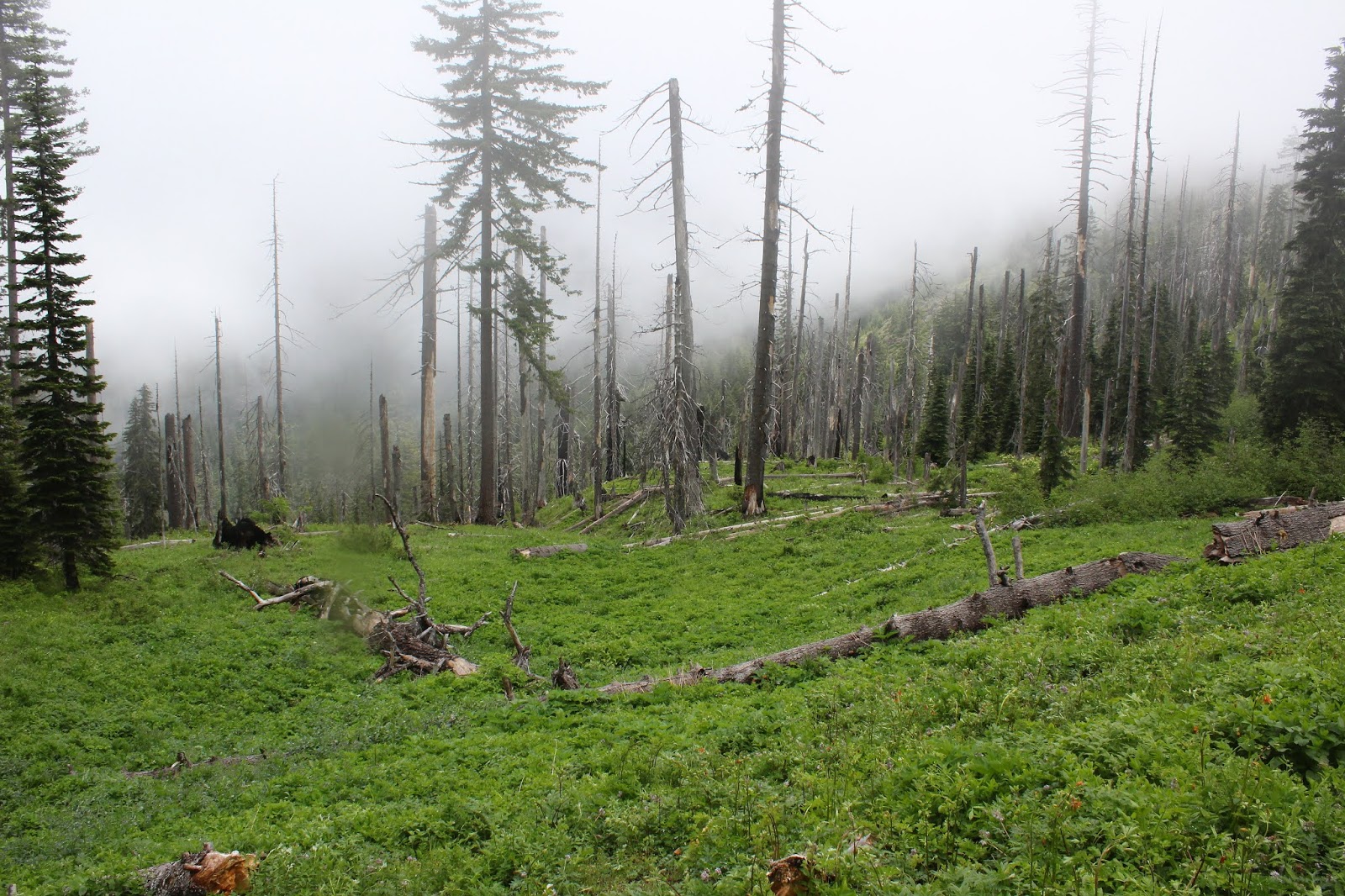
Misty view between Spring Mountain and Harding Butte


The clouds from that rainstorm were still hanging around, meaning the nearby mountains were hidden in the clouds and at times, we were hiking in damp fog. This trail basically followed a high ridge on the west side of Boulder Creek and (allegedly) serves up impressive views of Boulder Creek's formidable gorge. Of course, you need the clouds to go away in order to appreciate the scenery.

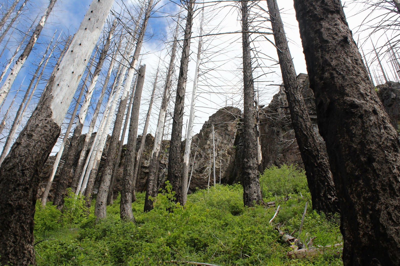
The ghosts of forests past


Fire visits Boulder Creek Wilderness frequently, apparently because the wilderness is the designated lightning spot for summer storms. There have been major fires in 1996 (which started on Spring Mountain, where we started from), 2006, and 2012. I'm not sure which of those three fires were responsible for all the charred ghostly snags and general all-around dearth of trees, but suffice to say live trees were in short supply on the foggy slopes of Spring Mountain.

Lane: Where'd the trail go?
Also in short supply was decent trail tread. The soil was rocky and the trail had obviously not been maintained since the Rolling Stones were young. Besides which, rampant greenery severely encroached the path, at times making it hard to see where exactly to safely place feet. The track was contouring across a treeless slope and with the relatively poor condition of the trail, ankles were put to the test as we hiked. However, I'm glad to report that no foot joints flexed in any direction other than the way they were designed to.

Meadowlark nest in the tall grass
So, while the rocky slopes were fire-scarred and totally devoid of trees, they were not devoid of vegetation and life in general. At my feet and in panic, a meadowlark burst out of the grass in startled flight and we pulled the grass back to observe the nest containing a quartet of blue eggs with red speckles. Meanwhile,  from a nearby bush, Mama Lark begged us not to harm her babies. Other life forms, in the form of profuse vegetation, were flourishing in abundance and wildflowers were putting on their annual spring gala. Not that our pace would have been fast anyway, given the roughness of the trail tread, but one of us just had to stop and take photos of everything blooming and twittering.

Ridge crest on Harding Butte


We soon left Spring Mountain behind and began contouring a rugged slope below flat-topped Harding Butte. As we did so, the cloud cover began to lift a bit, giving us teasing, but ever increasing vistas of the surrounding terrain. Rock formations resembling towers and pillars emerged into view on Harding Butte's crest above us and on occasion, we even enjoyed some direct sunlight, even though the warm light never lasted for more than a minute.

The trail was faint, to state the obvious


On a grassy saddle between Harding Butte and Wild Rose Point, Lane said something like "Here's the intersection" and I'm like "Where?". There was a faint path leading to Wild Rose Point next to a fallen tree, but no other trail was in sight, although both our GPSs said we were standing on a three-way trail junction. Lane stepped over the fallen tree and wow, there was indeed a faint path through the ample growth under a stand of what, up until now, had been nonexistent live trees.

I know just how that leaf feels


Basically this trail did a figurative U-turn, taking us round the other side of Harding Butte, eventually coming to contour across yet another treeless slope below the imposing butte. But first, we had to hike through some lush and ample meadows on a wooded slope. We were still fogbound at this point so the moisture in the vegetation had not yet evaporated and our wet pants got even wetter. Shoot, I might as well have just jumped into the North Umpqua River for all the dry that I was.

One misty moisty morning
No complaining though, for the meadows were simply beautiful. Creeks and small runoffs crossed the trail and boot interiors soon became soaked as well. A big pile of bear dooky on the trail was proof that bears do indeed poop in the woods. The forest soon petered out, the trail returning us to that burned forest vibe, although the meadows still remained on the open slopes.

Some of that Devils Stairway scenery
Just as we arrived at the base of Devils Stairway, the cloud cover lifted, sun broke out, and we could see. Hallelujah! Looming above us was imposing and rugged Harding Butte, now visible in its entirety. Across a large valley, rose the Calapooya Mountains with the peak duo of Fairview Mountain and Bohemia Mountain dominating the Calapooya skyline. To the south was Mount Thielsen, Mount Bailey, and other Cascades Mountains friends, the higher peaks still capped with snow. And of course, near and dear to us was the rocky ridge of Devils Stairway, and we picked our way up it, finally stopping to eat lunch amid the spectacular rock gardens on the ridge.

The Calapooyas rose on the other side
of Steamboat Creek's wide valley
After a nice appreciative view-soak and lollygag on our rocky perch, we returned back to the saddle below Wild Rose Point and grabbed the trail leading to the summit. We didn't have to gain much elevation from the saddle so it was an easy walk up to the flat-topped summit. Basically, we had the same view as from Devils Stairway, albeit from a slightly different angle, but which was even more spectacular as the clouds dissipated.

Harding Butte, in all its fire-scarred glory


Below us and to the west was the wide and deep valley carved by little Steamboat Creek, with the Calapooyas rising beyond. However, we could now see Wild Rose Point's nearest neighbors Illahee Rock, Spring Mountain, and Harding Butte, all of whom had previously been hidden in the morning cloud cover, aka fog. All the aforementioned peak neighbors were treeless, each being covered with a plague of dead trees fuzzing up each peak's otherwise sharp contours.

Wild rose on Wild Rose Point
All good things come to an end, especially on a short hike. However, the ruggedness of the trail and the epic scenery made this hike feel a lot bigger than it was. Could have done without the ticks we brought home with us, though, but that's just Lane complaining. I'm not complaining about ticks only because none bit me, neener neener! For more photos of this hike, please visit the Flickr album.


Saturday, November 2, 2019

North Umpqua Trail (Jessie Wright Segment)


Well, things were certainly a bit chilly on this early November morn! Jackets, ski caps, and mittens were items de rigeur down at the bottom of the North Umpqua River canyon, unless you're partial to frostbite. Things weren't always this cold, though. In the summer of 2017, part of the Umpqua Complex Fire(s) raged on the Jessie Wright Segment of the North Umpqua Trail (NUT) and the fire scars were visible throughout the hike. While we could have certainly done without the destructive wildfire, to be honest I wouldn't have minded rubbing hands together over a still-smoldering ember or two.

Lots of jackets, gloves, and ski caps on this crew

Fifteen humans and one dog commenced this hike with a short walk along the North Umpqua Highway. Since the trailhead parking is at the Marsters Segment trailhead, we had to cross the river on the roadway to get to the Jessie Wright trailhead. Upon setting feet on a real trail, the scars from the fire were immediately apparent. The fire here had been somewhat beneficial for although it killed the saplings, the older trees survived, proudly sporting scorch marks upon their trunks as a battle scar. In essence, the fire just cleared out the undergrowth, an aspect of wildfire that is actually good for forest health, although the slain saplings might object to that characterization.

A cold river of cold water on a cold morn

We all hiked pretty quick, for the the season was in that cold little space between fall and winter, but the exercise warmed bodies, minds, and souls. The sun was out and the sky was clear but unfortunately for us, the sunlight did not reach the bottom of the cold river canyon. The grasses and leaves close to the ground were dusted with a light coating of frost and the air was cold and nippy. But while the weather was wintry in some aspects, autumn still had a thing or two to say about that.

We hiked through fireweed patches that were dying off

The fall season was well represented by red and yellow leaves still hanging on the maple and dogwood trees. The first frosts of year had signalled to the bracken ferns on the ground that they too had to turn yellow and they so obliged. Dense patches of fireweed, already gone to seed, were beginning the winter shutdown process by browning out and dying off. Below the trail coursed the North Umpqua River, the waters looking black and cold as an ice queen's heart and definitely not tempting hikers in for a quick dip.

Mushrooms huddle together to keep warm

Mushrooms and fungi thrive in a post-burn zone because the dead trees provide ample food for fungi family members; it's like a decade-long all-you-can-eat feeding frenzy. Normally, the fungi organism is just a threadlike root existing underground until it's time to further the species by the process of reproduction. The mushroom or fungus that we observe above ground or on a tree is the reproductive organ, so to speak. In our area, it seems the peak breeding season for fungi is in November and accordingly, we observed all manner of fungi figuratively going at it on logs, fallen trees, standing snags, and on the mossy ground.

Trees both live and dead, post-fire

The trail climbed up to a point high above the river and stayed there as morning headed into afternoon. By the time we reached our turnaround point at Boulder Creek, the sun was rising over the tall ridges flanking the river and our hearts were gladdened while our bodies were warmed by the glorious light. It was nearly an anti-winter political statement when we defiantly shed outer layers and basked in the noonday sunlight. Begone, o tyranny of wintry chill, don't frost on me!

A dogwood basks in the warm sunlight

Jay and I soon lagged behind, our progress happily slow as we photographically enjoyed the autumn day now that sunlight reached our side of the river. The forest was by now bathed in afternoon light with lengthening shadows slanting through the trees. Sunbeams were hijacked and appropriated by vine maples sticking branches and leaves into the light, like somebody warming their hands over a smoldering ember. 

The North Umpqua River on a chill autumn day

In the morning leg of this hike, the river had a cold and forbidding appearance, running black in the absence of sunlight. But in the afternoon sunlight, the river was now colored dark green with white-watered rapids running bright and white. The sun also lit up what leaves remained with the big-leaf maples trending to yellow, the dogwoods to red, and the vine maples every available color from the warm end of the spectrum. The trail and forest were eminently beautiful, particularly coming as it did, after a wintry morning.

C'mon sun, you can do it if you try!

Poor Jay. He hails from Gujurat, India where the winter temperature might get down as low as 70 degrees. And here we were, hiking in the mid-40's, one of us clad in shorts and a T-shirt, the other clad in a parka, ear muffs, muffler, scarf, mittens, and battery-powered warming socks. Just about when he was beginning to question his moving to Oregon and becoming friends with me, we reached the trailhead and the car heater restored his happy good nature. It would be another three months before I could persuade him to go hiking with me again.

Dogwood colorizes the forest

For more photos of this hike, please visit the Flickr album.


Saturday, October 29, 2016

North Umpqua Trail - Marsters Segment

"X marks the spot" they say, even though I don't know who "they" are or why we listen to what "they" say, or even how you get to be a member of all-knowing "they". But for the purpose of this inane blog posting, the X-spot being referred to is where the North Umpqua Highway and the North Umpqua Trail switch sides of the North Umpqua River, with the crossover taking place at Marsters Bridge. The X also marks the spot where I began two hikes in two days on one North Umpqua Trail.

Trail tread
On the North Umpqua Trail, the Marsters Segment is yin to the Jessie Wright Segment's yang. You'd sort of figure they'd be pretty much the same but no, they do have their differences as well as some similarities. It's kind of like my brothers and I, we come from the same gene set but I wound up with good looks, athletic ability, and brains while they got a totally awesome big brother, but I digress. The Jessie Wright Segment runs on the sunny side of the North Umpqua River and ambles below some impressive geologic pillar formations. The Marsters spends a lot of shady time in lush forest way above the river. And the Jessie Wright is sunny and comfortably warm while the Marsters is cold and very wet, at least on the days I hiked the two trails.

Splish-splash on the North Umpqua Trail
As I blissfully slept the night of my Jessie Wright Segment hike, happily dreaming of riverine trails, a storm system blew in and the next day it was more a question of when and not if, as to whether I would get a rain soaking on the trail or not. However, at the hike's outset the sky was gray and brooding (just like me!) but the rain was still safely stored in the clouds above. Beginning at a backpacker's campsite next to the river, the Marsters Segment of the North Umpqua Trail ran straight through a soggy aisle flanked by spindly trees. Leaves carpeted the muddy trail which squished under my boots as I waded through the mud.

The river is just a step away
Within a quarter-mile of the trailhead, the trail shot up the hillside, climbing about 150 feet above the river. And then after all that work, the trail dropped back down to the river and then climbed several hundred feet above then river, and then....etc. You get the idea, the trail went up and down all day long. Fortunately, the uphill pitches were short and sweet, ending before legs went on strike. At times the path went cliffy, with the silty water of the river  flowing a straight couple of hundred feet below.


Bridge booby-trap (it's slippery!)
So, this is still autumn and on the shady side of the river, vine maples were still glowing yellow in the forest understory. Also making a significant contribution to the color show were big-leaf maple trees and dogwoods, with the dogwoods going as pink as a hairless mouse baby or one of my brothers. Occasionally, on the forest floor, individual fronds of Oregon grape were burning bright red. However, because I have seen that in all seasons, I'm not sure that the redness had anything to do with autumn or not.

Richard Creek..I mean, Deception Creek
Emerald-green moss flanked the trail in testament to the constant river moisture in the air. Likewise in liquid testimonial, small creeks ran over the trail with some frequency. Large creeks also crossed the trail but under, due to some finely constructed bridges. Only one of the creeks had a name, and Ray once said it was named after me: Deception Creek. I took it as a compliment!

Leaves in the rain


At just under the four mile mark, the Marsters Segment ended on a forest road crossing Calf Creek. As I ate lunch on the bridge, mindlessly contemplating the rushing water of the creek, I felt my first raindrop. After exchanging brief pleasantries with the only other person I'd see all day, a mountain biker and her dog, I returned to the trail for the return leg. It never fails, it always rains at the point farthest from the car, it must be like a weather god rule.

ISO 3200, stat!
But it was a mild rain and no complaints yet. At the three mile to go mark, the heavens absolutely opened up and now there was vigorous complaining. I made an attempt to put the camera away but the autumnal forest with its river views was just too beautiful not to take a picture of. So I compromised and took less pictures and walked just a bit faster. The day was dark, a statement empirically supported by an ISO setting of 3200 on my camera in broad "daylight". Too lazy to dig into my pack for my raincoat, I just put up with getting wet, but at least I was warm from the exertion of hiking. It was one happy but wet hiker upon return to the X where the highway, river, and trail all intersected.

A pair of puffballs
For more pictures of this hike, please visit the Flickr album.


Friday, October 28, 2016

North Umpqua Trail - Jessie Wright Segment

Way back when, when Dollie and I were newly married, we had to plan our first vacation as a married couple. I'm glad to report our marriage survived that experience! At any rate, I put a mason jar on the kitchen table and next to it were a pen and a note pad. The basic plan was when one of us had an idea for a vacation, we'd jot down our suggestion and drop it into the vacation jar. At some point in the future we'd select a vacation destination by reaching into the jar blindfolded, and grabbing the lucky sticky note. As it turned out, the two adults and the two children in the house had lots of good ideas and in no time that mason jar was full of great vacations. But then Dollie had to ask "When are we going to choose the vacation?" and I had to answer "The day we leave!"  I was serious, too.

A zen moment
Our conversation then continued in this basic form for the next several months:

Dollie: What if we go there and the campground's full?
Me: Then we stealth camp in the forest
Dollie: What if there is no motel room available?
Me: There is always a motel room available and if not, then we stealth camp in the vacant lot behind the motel.
Dollie: Grrrr....
Jessie and Aislinn: Which one of you gets us in the divorce?

Lemon yellow dogwood
I finally relented when one night, Dollie woke up in terror. "What's the matter?" I asked. Gasping for breath, she answered "I had a nightmare" as she wiped the cold sweat off her brow "I dreamed we were on vacation and we had no plans...I can't breathe." Clearly, this was becoming a psychological neurosis, so in the middle of the night, we reached into the vacation jar and pulled out a piece of paper with "Mount Rainier National Park" scrawled on it and our marriage was saved. Plus, we had a pretty cool vacation, despite its being planned in advance.

Autumn mosaic
So, now that we established that Dollie is order and I am chaos, no doubt you all are wondering what the heck does this parable have to do with hiking? Well, it's got all to do with my plans for backpacking in 2017. Normally, I decide where I'd like to hike and I say "I'm going there!" And then the week before, I get bored with my intended destination and read about another real cool destination in say, Backpacker Magazine, and then I'm off chasing squirrels, so to speak. And the day before I am to leave, I say "Sod it!", and wind up staying home dayhiking for the weekend because I couldn't settle on a backpack destination. So, this time I thought I'd take a page from Dollie's book and figure out where I'm going in 2017 and plan accordingly, repeating all the while Dollie's mantra : "Thou shalt not deviate from thy plan!"

Sunlit dogwood graced the trail
One of the trips on the list is the 78 mile North Umpqua Trail. The trail starts (or ends, depending which direction you hike) at Swiftwater Park, near the hamlet of Idlyld Park and finishes at Maidu Lake, the source of the North Umpqua River. The trail is divided into 12 sections with trailheads at either end and I've dayhiked most of the trail at one point or another. Because of its proximity to Roseburg, the North Umpqua Trail is just a short drive away and provides a nice day hike on days when one just does not feel like driving several hours to a more distant trailhead.


Tiny little parasol
So, on an autumn day where I was feeling lazy, Luna (our dog) and I hopped into the car and headed up the scenic North Umpqua Highway. After disembarking from the car at Marsters Bridge, we headed east on the Jessie Wright Section of the North Umpqua Trail. Immediately, our legs were soaked as the forest and encroaching brush were damp from the recent rains, although this day was sunny but cool. However, hiking at the bottom of the river canyon, we didn't get to experience the sunny joy much and we finished our hike with same low Vitamin D levels we had started with.

My future backpacking route if I don't change my mind
The first part of the hike was on what looked like an old road bed and the trail was gleefully level. Autumn was in full display as big-leaf maples were all glowing bright yellow above the trail. The vine maples were pretty much done but dogwood trees made up for their absence from the autumn fireworks display. The forest floor was likewise yellowed out with bracken fern, thimbleberry, and vanilla leaf all going gold in one shade or another. Dead leaves muffled the sound and the only noise heard was the rushing of the nearby river, our feet kicking the leaves, and an incredibly handsome lone hiker occasionally yelling at a dog who insists on pulling on the leash.

Creeks are to play in
The only animals seen were small twittering birds but Luna alerted a couple of times at something hidden upslope of the trail. I deliberately willed myself not to be too curious about what was lying in wait in the shrubbery and we walked by as quickly as possible which is not all that quick when the dog wants to just stand there growling. It probably just was deer stalking us.
The North Umpqua River was always nearby


So the trail was remarkably flat and I imagined myself hiking this with a backpack on. Wow, hiking this trail is going to be easy, it'll be level all the way to Maidu Lake! Heh heh, like that is going to really happen. Once off the old road bed and onto a real trail, the route went up and down for the rest of the hike, but fortunately none of the climbs were overly long. At times, the path got fairly close to the river running wide and fast due to the recent storms.

Thanks, Richard Sommers
Progress was fairly slow as this was more photo shoot than hike, there was just so much autumn finery to take pictures of. We did stop to eat lunch at Eagle Creek, admiring the rustic bridge spanning the creek. It used to be you had to wade across the creek but the Friends of the Umpqua Hiking Club paid for a bridge from an endowment received from Richard Sommers when he passed away. There was a sign honoring Richard and I made sure to thank him as we relaxed next to the creek flowing under the bridge. 

Bridge crossing of Boulder Creek
We continued on for another mile to Boulder Creek which was the logical turnaround point. The bridge offered up another contemplation point and we stopped for a bit to simply enjoy the creek rushing underneath. From there it was back the way we came, enjoying the idyllic scenery, our company, and autumn colors all over again. Fully sated in body and soul, we arrived back at Marsters Bridge and I'll be back on this trail, probably with a backpack on next time...unless I change my plans.    

Trail serenity
For more pictures of this hike, please visit the Flickr album.

Saturday, April 25, 2015

Pine Bench (with Boy Scouts)

Once it was discovered Daweson's grandfather is the "hiking dude" that writes for the News-Review, it was only a matter of time before I'd be asked to help his Boy Scout Troop 82 with a hike or two. Pine Bench was suggested as a destination because it is a short hike and the trailhead is fairly close to Roseburg. Of course, the last time I was there a couple of weeks ago, I wandered off trail and lost the trail altogether, so I'm not sure that I may not have been best choice to lead newbies into the wilderness. But they did not know that....

All hail Lord Daweson!
Because the scouts were a relatively inexperienced bunch, I gave them a speech about what to do when lost, showed them what poison oak looked like, crossed my fingers, and uttered a silent prayer to the hiking gods asking that I be allowed to return with the same amount of scouts we started out with. And with that invocation, we ducked under the large water pipes below Soda Springs Dam and headed up the trail. I was glad to see the fallen tree that had sent me astray several weeks ago had been cleared off the trail.

Uphill through a forest


Because my young charges were inexperienced, they were quickly huffing and puffing as the trail headed uphill to Soda Springs. Along with the huffing and puffing came the "How much further?" type of questions and along with the questions came my stock answer "we're halfway!" no matter whether we were halfway or not. Daweson and Issiah know the drill as they have hiked with me a time or two and they were just happy to be out on the trail. They also knew (from past experience) not to ask me how much further to go.

Stormy view down to the North Umpqua
All the bad uphill stopped after crossing a burn zone with the trail leveling off in the pastoral woods atop Pine Bench. The day was overcast and the skies were threatening, making for a moody and portentous view into the North Umpqua River canyon.


Pinnacle overlooking Boulder Creek
We ate lunch at the spring which had a nice overlook of the Boulder Creek chasm. Across the canyon, Illahee Rock was dusted with snow. As we ate and as the boys explored a nearby rocky pinnacle, the temperature dropped, a brisk breeze rolled in, and then it started to hail. Lunch was officially over and we headed back in the suddenly less than optimum conditions.


There's snow in them hills
I was bringing up the rear and noticed part of the group had missed the left turn at a trail junction.  I yelled at them and then we counted heads once everybody came back. We were one scout short: my Issiah. In his quest to be first back to the trailhead, he didn't get the message to turn back and now he was somewhere on his way down to the North Umpqua Trail.

Little Boy Lost
Remember my little lecture about getting lost?  Well, Issiah paid attention and once he figured out he was by himself, he did what his grandfather said to do: he stayed put! He did hedge his bets a little bit by taking his bright red poncho out of the pack and draping it over a small tree off trail for added visibility.  And sure enough, Scoutmaster Dave spotted the poncho well below us. I was quite pleased with Issiah's coolness under duress, that can make all the difference sometimes.

Witch's butter
So now that we had the proper number of scouts, we returned to the trailhead under blustery conditions but at least the rain held off for the most part. After it was all said and done, the boys were openly appreciative of the experience. I think we're halfway there!

We're halfway there!
For more pictures of this hike, please visit the Flickr album.