Showing posts with label Elk River. Show all posts

Saturday, January 25, 2020

Cape Blanco (via Sullivan Gulch)

This seemed like such a simple undertaking. Hike about 2.5 level miles to the beach, follow a ridge to the Cape Blanco Lighthouse, make a beach walk to the Elk River, and then back on a flat trail to the trailhead. So easy, what could ever go wrong? Well, the weather, for starters. An eight-foot foot high tide, too. And a mile of mud puddles, let's not forget those, either. Nice to know I still have the Richard Hike touch.

Twenty-nine hikers took the green flag
The weather forecast called for 100% probability of rain but you'd never know that when the Friends of the Umpqua gathered at the meeting place in Roseburg. My theory about only three morons show up for a hike in poor weather was put to lie by eight hikers who piled into cars under a remarkably clear blue sky. While the weather was somewhat cloudy and foggy by the time we arrived at Cape Blanco, the air was nonetheless happily dry and there were twenty-one more hikers waiting for us, courtesy of our sister club the South Coast Striders. Wow, twenty-nine hikers to keep track of and I immediately felt sorry for the hike leader, which was me.

Wetlands, accent on the wet
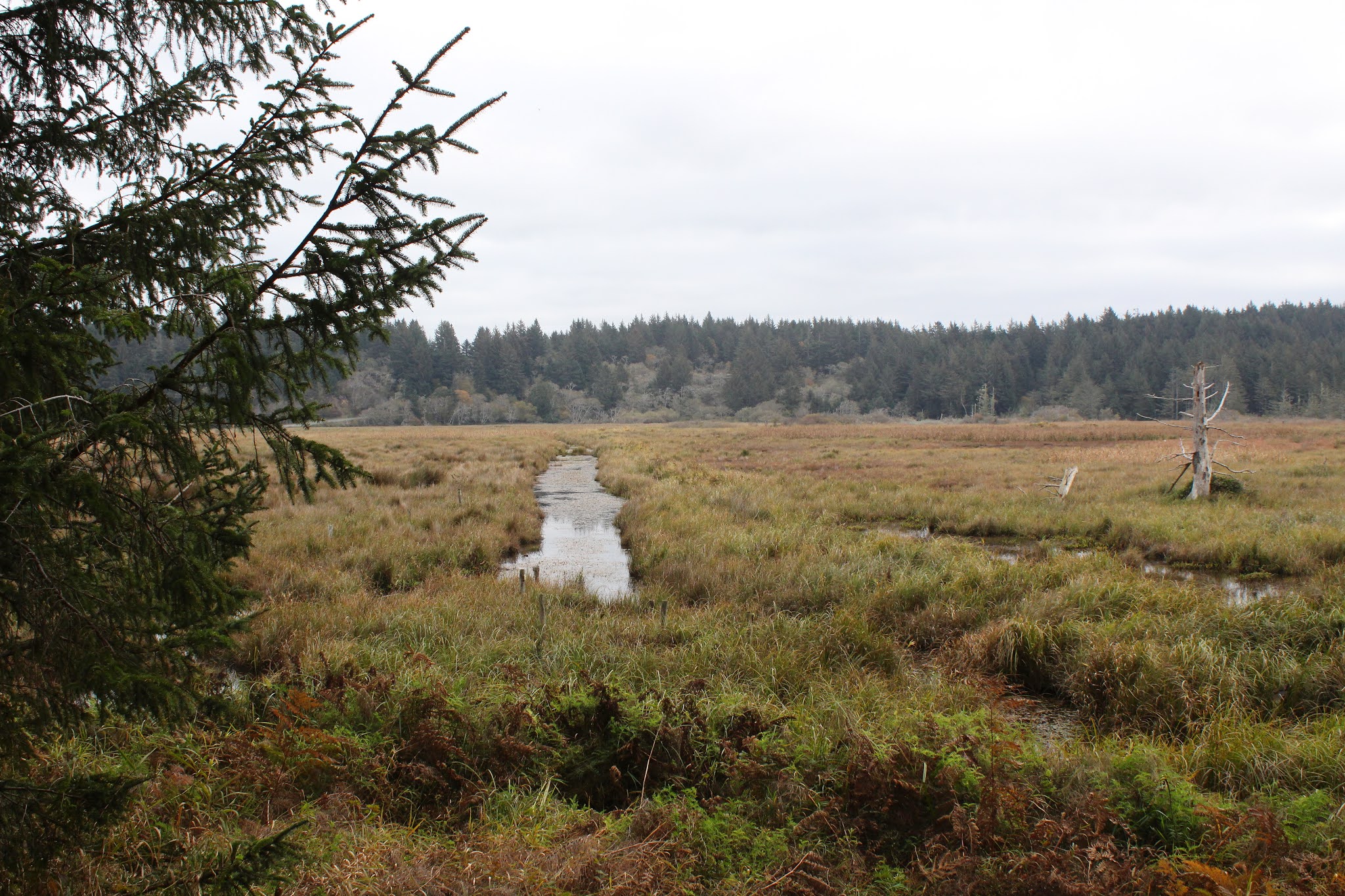
From a large parking lot on the Cape Blanco park road, we executed a short walk on the road to a gate, opened said gate, and then commenced hiking in earnest. The first part of the hike was on a grassy path that looked like it had been a jeep or farm road in in its prior incarnation. The path basically followed the edge of Sullivan Gulch, a large marsh in a broad valley. The waterlogged gulch was full of overgrown ponds, canals, and other amorphous wetlands that faded into the fog. Didn't see any waterfowl though, they had either sought shelter from the impending storm or had fled the arrival of twenty-nine hikers. Smart birds, either way.

Scraggly alder trees
Besides sideswiping Sullivan Gulch, the trail provided plenty of quality coastal forest time over the several miles to the beach. Leafless alder, their branches stark against the gray sky, contrasted nicely with the evergreen conifers flanking the path. In a taste of things to come, large muddy puddles lay across the trail, forcing dainty hikers to tiptoe around them to keep feet clean and dry.

Nice view for a few minutes
After a pleasant walk to the dunes overlooking the beach between Cape Blanco and the Elk River, the first little downer reared its salty water head. I knew it was going to be high tide (check your tide tables before you go beach hiking, boys and girls) but since the beach here is fairly wide, I was hoping there'd be some way to hike to the Elk River. The decision to hike to the Elk was postponed until we could visually assess the situation and one look at the eight-foot tide covering ALL the beach sent me figuratively scrambling for Plan B.

The storm arrives
Plan B was a hike up the spectacular coastal bluffs where we'd eat lunch on the high point thereof, followed by a short amble to the cape itself. After a brief uphill ridge walk, we all sat down upon arrival at the high point, munching our various lunches and snacks, and admiring the awesome view as we ate. While slightly overcast, the sunlight made it past the clouds here and there, casting spotlights that flitted and fluttered upon the silver ocean surface. Further to the south, the sky was ominously black and the rugged Oregon coast simply disappeared into the heavy dark mist. The storm was coming and mere minutes later, it was pretty much arriving, about as welcome as a visit from the mother-in-law, as we cut our lunch short to skedaddle.

Remnant of a steam donkey
From our lunchtime coastal overlook, the trail ducked into a heavily wooded forest with traces of mist sifting through a skein of tree branches. Some of us stopped to gawk at the ruins of a steam donkey, the mossy and massive timbers a nostalgic reminder of logging operations of yore.

Here is where the rain caught us
We grabbed the Oregon Coast Trail at the campground and the trail spit us out onto the windblown and barren grassy bluffs just south of the lighthouse. Naturally, since we were out in the open, it figured that would be where the storm would catch us, all unprotected and exposed like that. By the time we reached the lighthouse parking lot, there was unanimous and silent wordless agreement that this was as close to the lighthouse as we needed to be. The wind was gusty, but not as yet as powerful as was forecast. The rain did pick up in intensity, putting all our rain gear to the test. It was at this point I ruefully removed the battery from my camera and stowed the camera in its case, to be safely inoperative for the rest of the day. From prior experience, it's kind of an awkward conversation between me and Mrs. O'Neill when the conversation begins with "I have to buy a new camera!", no sense repeating that dismal experience for the fourth time.

Stormy afternoon at Cape Blanco
Too bad the camera was temporarily retired because it might have been fun to photograph hikers navigating deep and wide mud puddles for a mile or so before the trail plunged rapidly down to Sullivan Gulch. First there was one small puddle and hikers could step over and around with no problem. Next puddle was larger and the dense coastal huckleberry bushes flanking the trail effectively deterred hikers from bushwhacking round. Then the puddles were tens of yard long and ankle deep and the only thing to do at that point was just splash through, dry feet be damned. My feet were fairly dry because my high-ankle boots are waterproof but most hikers had trail-runners or some facsimile thereof, and the sound of water squishing inside shoes could clearly be heard, along with mutinous mutterings about a certain gleeful hike leader who was obviously enjoying the whole splashy experience.

Misty forest
The precipitous descent down to Sullivan Gulch was safely executed, and I witnessed no pratfalls, be they mine or anybody else's. Most hikers were fairly philosophical about the hike, noting that we were hiking at the coast in January and the inclement weather is to be expected. But they didn't thank me, either.

Rain clouds deliver
Because of the heavy rain, I didn't take my usual quota of pictures, but what few I did take are in the Flickr album.


Saturday, November 9, 2019

Cape Blanco (via Sullivan Gulch)


Cape Blanco State Park is one of my favorite places to hike at. To nit-pick a bit though, there's a sameness to the trail network in that all possible routes essentially follow the coast from the Sixes River to the Elk River or vice versa. Yes, you can hike either atop the forested coastal bluffs or on the beach but either way, you are pretty much hiking from the Sixes River to the Elk River or vice versa. But as I recently found out, there is an inland approach that begins at Sullivan Gulch. Yay, somewhere I'd never hiked before, and naturally, the alluring "new trail" siren song called out to me. Powerless to resist its haunting melody, I soon found myself lacing boots at the cattle gate that serves as the Sullivan Gulch trailhead.

For some reason, we did not take this trail, not really sure why that was

Accompanied by my trusty sidekick Lane, I opened the cattle gate and our hiking festivities commenced with a walk up a grassy ranch road flanking the west side of Sullivan Gulch. Per the Oxford English Dictionary, "gulch" is defined as a "narrow and steep-sided ravine marking the course of a fast stream". Well, Sullivan Gulch is not narrow, nor is it what I would call a ravine, and good luck finding a fast stream in the marshy wetlands. The wide swale with plenty of standing water in it does have steep sides though, but the trail here sort of cheats past by finding a gap in the steep sides on its way to the beach.


Waterway in the Sullivan Gulch wetlands

The first part of the route followed the wide grassy marsh containing ponds, drainage ditches, and various other forms of standing water in and among the marsh grasses. Ducks make a home in the ponds and regrettably, our arrival caused them to flee their watery abode in quacking panic. A more intimate exploration of the gulch was effectively discouraged by wire fencing and standing water, so we just looked and did not touch.

Mother and child, toxic mushroom style

It didn't take long for both of us to decide we really like this trail. The path gradually left the edge of the marsh and we hiked in woods sublime. White-trunked alder trees were already leafless, proffering their bony limbs to the sky in supplication for the return of leaves purloined by winter's arrival. Closer to ground level, the greenery was still thriving, unwilling to surrender their leaves like weak-willed alders. Ferns draped over the trail and mushrooms were everywhere. This was too much to expect two dudes with cameras to walk through without engaging in much photography. Consequently, it was slow going through the woods to an overlook of the beach from atop a tall dune.

Bushwhacking is fun!

Before we hit the beach though, we followed an obvious path leading into the forest, curious to see where it went. 
As it turned out, it pretty much went nowhere. The well-defined path quickly degenerated into a loose network of deer paths, game trails, and thick forest clawing at us as we fought our way up a ridge. Eventually, we wound up at the edge of Sullivan Gulch, wrestling head-high grasses while mud sucked at our boots. While fun, the bushwhack venture yielded little reward, so we bushwhacked back to the sandy saddle above the beach.

The mighty Elk River

The tide was out and the exposed wet sand was hard-packed (just like my abs, hah!) and perfect for hiking on. We beach-walked south for about a mile before the swiftly moving Elk River barred further progress south. Surprisingly, the fairly remote river was in use by a moderate population of salmon fishermen. After an obligatory lunch and laze next to the river, Lane and I returned to the overlook atop the dunes.

A sea of silver mercury

Feeling adventuresome and walky, always a potent situation, we grabbed a footpath that headed straight up through some woods. The whole vibe of this section of trail felt like wilderness because we did not see a single soul as we trudged upward. The trail served up some expansive views of Sullivan Gulch and the beach south of Cape Blanco as our route zigged and zagged from the ridge crest to the east side and then back again. After a mile or so of this, the path crested at what presumably is the tallest point in the park.

Flocks of geese head north

Oh, the things we could see from the top! The beach lay immediately below our clifftop perch, albeit several hundred feet below. Fishermen and beachgoers looked like ants on a kitchen counter and their vehicles like little Matchbox toys waiting to be picked up by a giant hand. Offshore loomed the ocean, glinting silver in sunlight diffused by an indistinct cloud layer. Ah, now this is why we hike!

Lane and Richard go for a hike

After admiring the view from our clifftop aerie, it almost seemed anticlimactic to cut across the horse camp and take the trail back to Sullivan Gulch. However, the forest was lush and green and the trail challenged our legs as it dropped straight down into the gulch. I do mean straight down, for the trail plunged as fast as a wingless duck, putting our quad and glute muscles to the test as we bravely resisted the pull of gravity on the way down. Once back down to gulch-level, the hike was finished off with a short walk on a grassy path covered with crawling newts. I think this is my new favorite hike at Cape Blanco State Park.

They say the spirit of Sullivan still haunts the park

For more photos of this hike,
please visit the Flickr album.


Saturday, January 13, 2018

Cape Blanco 1/2018

Several weeks prior to this hike, Lane and I had hiked at Cape Blanco on the Best Day Ever. Nothing could top the magic of that December day, but Round 2 sure came close. The only reason this January day came up shorter than that December hike, was a slight misty haze at beach level. But that's just me nitpicking, for this day was bright, sunny, and cool enough to qualify as a perfect hike when not compared to the Best Day Ever.

The queen and her human
I had gone hiking at Cape Blanco with Lane on that December day because he was going to lead a Friends of the Umpqua hike there, but had never been. So our venture to the cape was to familiarize him with the route and thereby impart some degree of competency to his leadership. But on this January day, I went again because there was like about 40 hikers that showed up and Lane needed moral support if not some out and out assistant co-leading. I'd like to think the multitudes showed up because they were inspired by my brilliantly written blog, but that little theory is quickly disproved by the average head count of 3 attendees per Richard Hike.

Nature's track lighting
Anyway, the thundering hordes set out on the Oregon Coast Trail which cut across the grassy pastures flanking the Sixes River. Lane hung back and I walked somewhere in the middle, to direct hikers at the numerous trail junctions between the Sixes and Cape Blanco itself. Because of a high tide, we saved the beach walk for the end of the hike, heading instead through the dark woods overlooking the beach below. Very little sunlight penetrates the thick forest on top of the coastal bluffs, making this stretch of trail one of the darkest places found on this planet. However, on a sunny morn, sunbeam spotlights illuminate the trail here and there.

View to Cape Blanco, as we left the forest
The walk through the dark forest was broken up by several side trips to intermittent overlooks of the Oregon Coast. After a mile or so of this, the path broke out onto the grassy cape itself and our eyes watered in the sudden exposure to bright sunlight. The day was glorious and we basked in the sun as we enjoyed lunch next to the historic lighthouse atop the cape. Lunch and basking is always more enjoyable with a view and to the north, an epic vista to the Sixes River and Blacklock Point, with all manner of islands dotting a bay of blue water, entertained lunching baskers (or is it basking lunchers?). To the south, a long beach arced towards Port Orford with Needle Rock being a prominent feature below the cape. A thin layer of mist clouded up the beach while it was nothing but blue skies atop the cape. Life was definitely good!

From Cape Blanco all the way to Humbug Mountain


After a lazy lunch, our rather large group straggled out back onto the trail which entered another thick coastal forest after an easy ramble along and atop the windblown bluffs. Once we went past the campground, a short road walk dropped us down to beach level about a mile south of Cape Blanco. To the south rose the forested mound of Humbug Mountain with the rest of the coast disappearing into the misty haze.

Driftwood swirly
From here on in, it would be pretty much a beach walk back to the car, although the beach walk was bisected by the formidable redoubt of Cape Blanco. Large driftwood logs lined the beach below the yellow (gorse was blooming on the hillsides) cliffs. At the end of the beach, Needle Rock loomed, seemingly trying to pop the blue sky balloon above. We all sat and rested for a bit, gathering our strength for the steep climb to the top of the cape.

Ugh!
This was the first time I had hiked this loop in a clockwise direction and "Ugh!" is all I have to say about the hike up. There is no official trail, just a muddy goat path that is challenging enough on the descent, never mind the daunting challenge on the way up! Looking down at the beach on the climb up, we spotted small army of hiker ants marching on the sand and stopping to rest at Needle Rock like we did.

Gulls taunt the dog from across the river
Another steep and muddy path took me off the cape and down to the beach on the north side. I unleashed Luna and she was overjoyed at her freedom and I was somewhat inspired to keep walking by watching her frolic and caper in the waves. A mile later, we arrived at the Sixes River, which was carrying a lot more water than it had been during our December visit. A flock of seagulls napped on the opposite bank, much to the consternation of Luna who could see but not chase the gulls across the river.

Light show
In December, a herd of sheep had been grazing in the pastures flanking the Sixes River, but they were not there any more. That was a good thing, considering I was walking an easily excited dog at the end of this hike. All in all, this wound up being another great hike on another great day at the Oregon coast, even if the day did not match the standard of the Best Day Ever.

Spiders try to snare passing hikers
For more pictures of this hike, please visit the Flickr album.


Sunday, December 10, 2017

Cape Blanco

If this was not the best day ever on the coast, then it was at minimum, the second best day ever on the coast. In Roseburg, December 2017 will forever be remembered for a protracted air stagnation weather thingy that resulted in dense fog smothering the Umpqua Valley all day and every day, or at least for 57 days of the month. So, by time Lane, Colby, and I drove over to the coast for a hike, the dearth of sunlight had nearly become a medical condition. Probably some kind of neurosis, too. Maybe even a psychosis. At any rate, the lack of sunlight had us all standing under florescent lights in the kitchen, in a vain attempt to remember what sunlight even felt like. Given all that, it was nigh a religious moment when we parked the car at Cape Blanco under a cloudless blue sky.

Needle Rock is the Oregon's largest candle
The temperature was balmy too, hanging around 60 degrees all day. It was absolutely glorious to be able to hike in shirt sleeves under sun and sky. We weren't the only ones enjoying the weather either, as other hikers were also out and about, taking advantage of this miraculous turn in the weather. Even the wildlife were deliriously happy to bask in the sun, as evidenced by a fox skittering into tall grass, its restorative sunbathing rudely interrupted by our drive-by.

A very large Boulder Bar on the Sixes River
We grabbed the trail that follows the Sixes River to the beach, and it's always amazing how the Sixes rearranges itself from season to season, On this day, the river coursed past a boulder bar that had never been as large or extensive on my prior visits to the area. Same old sea lions, though, and one popped out of the cold river to enjoy the sun on the opposite bank, and we could totally relate.

The end of the Sixes's journey
Startled by our intrusive arrival, a bald eagle rose up from the grassy pasture, majestically soaring towards Castle Rock. The Sixes pooled languidly behind the beach and ripples from large watery sea creatures swimming just under the surface had us wondering what kind of creatures they were. I guessed mermaids. Where river met sea, an otter fled the beach and disappeared into the waves, conceding the sand to us humans. Wow, that was quite a lot of wildlife diversity for just a half-mile of hiking!

Castle Rock, looking particularly castle-ish
Castle Rock, a large island in front of the Sixes River mouth, dominated the scene as the beach arced to eminently visible Cape Blanco, the historic lighthouse affixed to it like one of Lane's birthday party hats. The bay between us and the cape was scenically cluttered with random rocks and islands strewn about, with Gull Island and Castle Rock being the only two deemed worthy enough to merit a name by the Oregon Geographic Names Board. 

View towards Blacklock Point
The sand is very soft on the beach and Lane and I were having PTSD (Plenty of Trudging in Sand, Darn it) flashbacks to a past three-day backpack trip along the coast, but the splendiferous sunlight somewhat eased our mental anguish. After a mile of not-so-painful hiking in soft sand, the beach ended at Cape Blanco itself and the soft sand was exchanged for the solid dirt path charging up the grassy coastal bluffs. Getting to the top of the bluffs was work, so a stop-and-gawk at the historic lighthouse was in order, as was an early lunch. Sun, sky, views, lighthouse, and a jalapeño sandwich: life was good, indeed.

A giant dragonfly, hunting giant mosquitoes
There was a group paragliding off the cape and we observed them practicing their craft, riding the wind currents like giant dragonflies. Cape Blanco is renown for high winds and holds the record for the highest recorded wind speed in Oregon; the record being 179 miles per hour on what surely must have been a memorable day in 1964 for all the wrong reasons. Don't think the paragliders of the time were riding wind currents on that particular day. If they were, they probably landed in Topeka.

City on a hill
A steep and muddy track down the south face of the cape dropped us on the beach. Fortunately, we all remained upright on the descent, although there were a few near misses. A pointy spire with the descriptive name of Needle Rock marked the start of the next segment of beach walking. I'm not sure why sand is piling up against the imposing cliffs here but perhaps rising sea level is the culprit. My little theory is that the rising ocean is bringing more sand onto the beach and because of the cliffs, the sand has nowhere to go. Trapped between surf and cliff, the sand unhappily accumulates at the base of the cliff. At any rate, the damp sand had been eroded by wind, surf, rain, and sun; the resulting formations were amazing, resembling so many ancient cities carved into mountains.

Deep, dark woods
Less than a mile later, we arrived at the driftwood pile where the Cape Blanco Campground road met the beach, and that was our cue to leave all the sand behind, and burning leg muscles were grateful. But not so fast, leg muscles, you still have a short but steep climb yet to perform. The paved roadway climbed briskly to the top of the coastal bluffs, the keyword being "up". Fortunately, the uphill grade mellowed out a bit when steep pavement was exchanged for mostly level dirt-treaded Oregon Coast Trail. The OCT threaded its way through a dense and dark forest before abruptly spitting us out into the bright sunshine atop the bluffs.

The forest is too dense to bushwhack through
Blinking myopically like blind cave salamanders in the open sunlight, we followed the trail through dense growths of waist-high salal. We had spent most of the day hiking, so by now the sun was sinking low, imbuing the coastal scenery with the soft golden light that heralds the imminent arrival of sunset. At the cape, we enjoyed the epic view towards Blacklock Point, the Sixes River, and Castle Rock in the fading light. Instead of returning by way of beach, we entered the forest and continued hiking on the OCT.

Gull Island in a big ocean
Man, it was dark in them thar woods! The trees are packed so closely together that not much light penetrates the dense tangle of branches. The deep shade would be nice on a hot day but at the end of the day, the woods were darker than a black hole in space. We did reacquaint ourselves with what daylight looked like by taking a short side trip to a viewpoint overlooking the coast.

Not so wild life
We had seen quite a bit of wildlife on this trip and there would be one more wildlife encounter when we inadvertently ambled into a flock of sheep on the descent into the grasslands flanking the Sixes River,  Panicked, the sheep comically ran down the only place they could, which was the trail. So we got to scare them for a half mile or so, good thing I didn't have Luna with me, she would have made sure the sheep got plenty of exercise.

Lane and Colby enjoy a father-son hike
So, on this hike we saw wildlife, experienced awesome coastal scenery, and most of all, enjoyed a superlative sunny day. The only blot on the day, however, occurred on the way back when a pickup towing a trailer in front of us left the road and spectacularly wiped out in a ditch. Fortunately, nobody was hurt in the accident. Hiking is so much safer than driving!

Colby carefully picks his way down Cape Blanco
For more pictures of this hike, please visit the Flickr album.


Saturday, December 29, 2012

Cape Blanco

The weather had been wet and cold and it'd been three weeks since I'd last set foot on the trail. The need to hike was fast becoming a medical condition. Fortunately, the weather gods decided to bestow favor upon us waterlogged Oregonians by giving us a sunny, albeit cold, day on the last weekend of 2012. Not wanting to appear impolite by spurning the sunny gift, Maggie The Hiking Dog and I headed to Cape Blanco to work off some post-Christmas dinner calories with an 8.7 mile hike.
Castle Rock, seemingly sitting in a field
The shadows were still long in the morning sun as we got off to an early start. Sallying forth from the historical Hughes House at Cape Blanco State Park, we strode across a grassy pasture alongside the Sixes River. Castle Rock, a prominent rocky island, appeared to be sitting in the middle of all the grass as the ocean was not yet visible. Maggie, totally in her element, splashed happily in the large puddles on the trail.

View to the Sixes River
We eschewed the beach walk on this particular hike, heading instead uphill on the Oregon Coast Trail. A muddy climb up a wooded bluff took us to a nice view of the mouth of the Sixes River. It was interesting because two months earlier, John and I had camped at the mouth of the Sixes and we had crossed back and forth across  the Sixes on a sand bar damming the river. However, that was then and now the Sixes was carrying a lot of roaring water through the demolished sand dam.

Trail tunnel
Staying in some incredibly dark woods atop the ocean bluffs, the trail basically cut across the neck of Cape Blanco. After a mile or two, the trail spit us out of the coastal forest and offered us a nice view of windswept and grassy Cape Blanco jutting out into the ocean with the famed lighthouse affixed atop the cape like a New Year's party hat on a drunk reveler.


Beauty at the campground
Bypassing the lighthouse (been there, done that) because we had more miles to hike, we crossed the headlands, covered with a dense growth of wind-stunted salal, before re-entering the woods. A short walk brought us into the hiker and biker camp at the Cape Blanco Campground. Maggie and I walked through the campgrounds where campers exclaimed "How cute!" followed by much head patting and chin scratching. I think Maggie was jealous I was getting all the attention.

The only thing needed for a beach hike was a beach
Disappointment awaited us at the beach as the tide was high with waves rolling up all the way to the end of the paved road from the campground. The beach was covered with an ankle-breaking pile of logs and debris at least 10 yards wide, leaving no sand to walk on.  Would this be a prematurely ended hike or would this be instead a Richard Hike? That was the question.

Maggie explores an upside-down stump
I answered the question by waiting for a wave to recede and then running or walking fast before the next wave rolled in. As the next wave came in, Maggie and I would then seek safety on top of the log piles and then repeat the whole process over again when the wave receded. While the going was slow, we did manage to cover about half a mile before finding easier going on the dunes behind the log piles.

Tsunami debris
There has been so much driftwood piled on our beaches this year, it may be from the tsunami in Japan. There was plenty of obvious tsunami debris such as pop and water bottles but most of the debris consisted of logs, indeterminate pieces of lumber, and a gazillion little pieces of plastic. Some of the debris, like flip-flops, plastic baseballs, and baby rattles, were profoundly poignant and tragic. I picked up a water bottle, imagining a pair of hands placing the bottle into a shopping cart, the hands' owner at the time being totally unaware of the disaster that would befall northern Japan. Just an ordinary household item, lying on an Oregon beach, brought here by such a horrible tragedy.

Incoming!
So, between dune-walking, wave-dodging, and log-hopping we made slow and steady progress on the beach towards a tall and sheer cliff. At the cliff the sand petered out altogether, marking an unexpectedly early encounter with the Elk River.

Let's hike across the Elk!
According to my maps and guidebooks, the mouth of the Elk River should have been further south. But a water laden river goes where it wants to go, and the Elk has migrated north by running right under the cliffs paralleling the shore line. A sandy island across the way was not an island at all; upon closer inspection the island instead was the spit of sandy beach on the other side of the river.

The Elk River meets the ocean
The official Oregon Coast Trail calls for walking across the Elk River to which I reply "Are you freaking kidding me?" The river was wide, deep, turbulent, and running fast and strong. No way. Maybe in the summer, but there'd have to be a lot less water in it.

The beach is made entirely of wood


The river clashed violently with the ocean, causing waves to form with no rhyme or reason. The waves came ashore unpredictably from all angles and directions and I kept my head on a swivel as there was precious little sand to stand on. A large wave erupted forth for no apparent reason and I hopped atop the driftwood pile. The wave kept coming and the pile began to shift and move with ominous cracking sounds.  I learned a new skill: doing a speedy 50 yard dash atop moving logs. When the wave receded, it was time to leave: the mouth of the Elk River was indeed a very dangerous place.

Cape Blanco at the end of the day
The trip back was pretty uneventful as the tide had receded enough to allow us to walk on the beach with just the occasional wave chasing us up into the logs. As we headed back to the car, the shadows lengthened and we enjoyed views of the cape, Castle Rock, the Sixes River and all points in between. It was a nice way to close out 2012.

For more pictures of this hike, please visit the Cape Blanco photo album in Flickr.