Showing posts with label oct. Show all posts

Sunday, June 6, 2021

Blacklock Point


With a missionary's zeal, I preach the Gospel of Hiking and to indoctrinate a would-be lifelong devotee, it usually takes one good hike explicitly selected by yours truly for that purpose. However, some converts are more challenging than others. Case in point being long-time friend Anne, who submitted a voluminous pre-hike list of things that could not occur on this outing. Apparently she reads my blog so the list had things like "...no poison oak, no ticks, no wading of rivers...etc." It also had more esoteric items like "...no puns, no spontaneous songs, no armpit farts..." Sheesh, I wasn't sure I had any such hike (or behaviors) in my repertoire!

Archway on the beach

Also enumerated on that list were some weather-related edicts like no thunder, lightning, hail, wind, rain, or any combination thereof. Fortunately, a perfect day awaited the three of us (Anne's husband David came along, too) at the Oregon coast. The forecast had called for a cold, windy, and sometime rainy day but the reality was that the sky was cloudlessly blue, the temperature mild, and the breezes minimal. All signs pointed to a great hike for distrusting newbies and one erstwhile jaded veteran.

The Oregon Coast Trail tunnels through a dark forest

The long version of the Blacklock Point hike is a loop route and we opted to do the less scenic portion of the hike first. That meant starting out by walking behind an airport runway while keeping an eye on the sky for any approaching planes (running from airplanes was on Anne's list, too). After that propeller-free travail, the next couple of miles were a gradual descent on a jeep road through what admittedly were beautiful woods, even if there were no big-ticket items to see.

This bud's for you!

It was late spring and accordingly, the rhododendrons were still putting on a show. The large pink flowers festooned branches well above our heads and my two charges soon found out I brake for flowers. Close to the ground, the trail was flanked by blooming trapper's tea bushes and one patch of beargrass, somewhat out of place at the coast, proffered their distinctive white flowery plumes beneath the rhodies for our perusal. 

Our view of Floras Lake

Well, after a nice little three mile stroll through the trees and wildflowers we popped and plopped out onto a bare open area overlooking Floras Lake. This little lake is often busy with gossamer-winged kite surfers but not today, probably due to the lack of wind. David has a friend who lives at Floras Lake and he tried to spot the home from our vantage point. Whether looking for homes or kite surfers, we all agreed this was the first of many grand views on the day.

Fern tentacles

We backtracked a little bit on the Oregon Coast Trail which tunneled through a forest of dense trees twisted into all sorts of phantasmagorical shapes by near-constant sea breezes. The mix of sun and shade dappled the trail and delighted us hikers striding purposefully on the path. Rhododendrons were not as much of a thing in this part of the forest but the trail was graced nonetheless by ample quantities of wild irises ranging from purple to pale lavender in color.

It's a Richard Hike!

So far, I had managed to keep within the bounds of Anne's oppressive pre-hike manifesto, but a foot-deep creek presented the first test of our friendship. I simply splashed through, David walked across on some small branches, and Anne, surrendering to the inevitable, took off her shoes and waded barefoot, the mud presumably oozing between her toes. Expecting to immediately get unfriended, I was pleasantly surprised when she said the cool water felt good. 

Life on the edge

There is a viewpoint atop the coastal cliffs that, in my opinion, presents the Best View Ever. In years past, a bushwhack through dense coastal shrubbery was required to get there but eventually that faint path became overgrown and lost forever. Nonetheless, we tried to use the old path but couldn't get past the impenetrable growth and we all sported scratches as souvenirs of our failed attempt. Fortunately, I knew of an easier way to get there ("Why didn't you go there in the first place?" says everybody) and while that did require some bushwhacking, at least the bushwhacking took place on the edge of a sheer cliff. 

Our reward for the bushwhack

We did attain the intended viewpoint where the cliffs were covered by dense mats of inch-high dwarf lupines. We all plopped down to lupine level to take photographs of the diminutive flowers and their many attendant bumblebees. And of course, there was the epic surf, coast, and cliff scenery curving to the north under an amazingly superlative blue sky. Much nature appreciation abounded.

Cape Blanco presides over this bay

On the latter part of the hike, we stopped at other, and easier to access, viewpoints but none were imbued with the very secretness enhancing the vista seen from the special hidden overlook we had visited. However, the ever evolving coastal panoramas were still worthy in their own right. The last of these viewpoints was atop Blacklock Point itself, with a row of islands stretching west like an oceanic chain of pearls. Wind-stunted wildflowers grew on the point's summit while Cape Blanco presided at the end of a long curving beach to the south and we just sat and soaked in the view for a while.
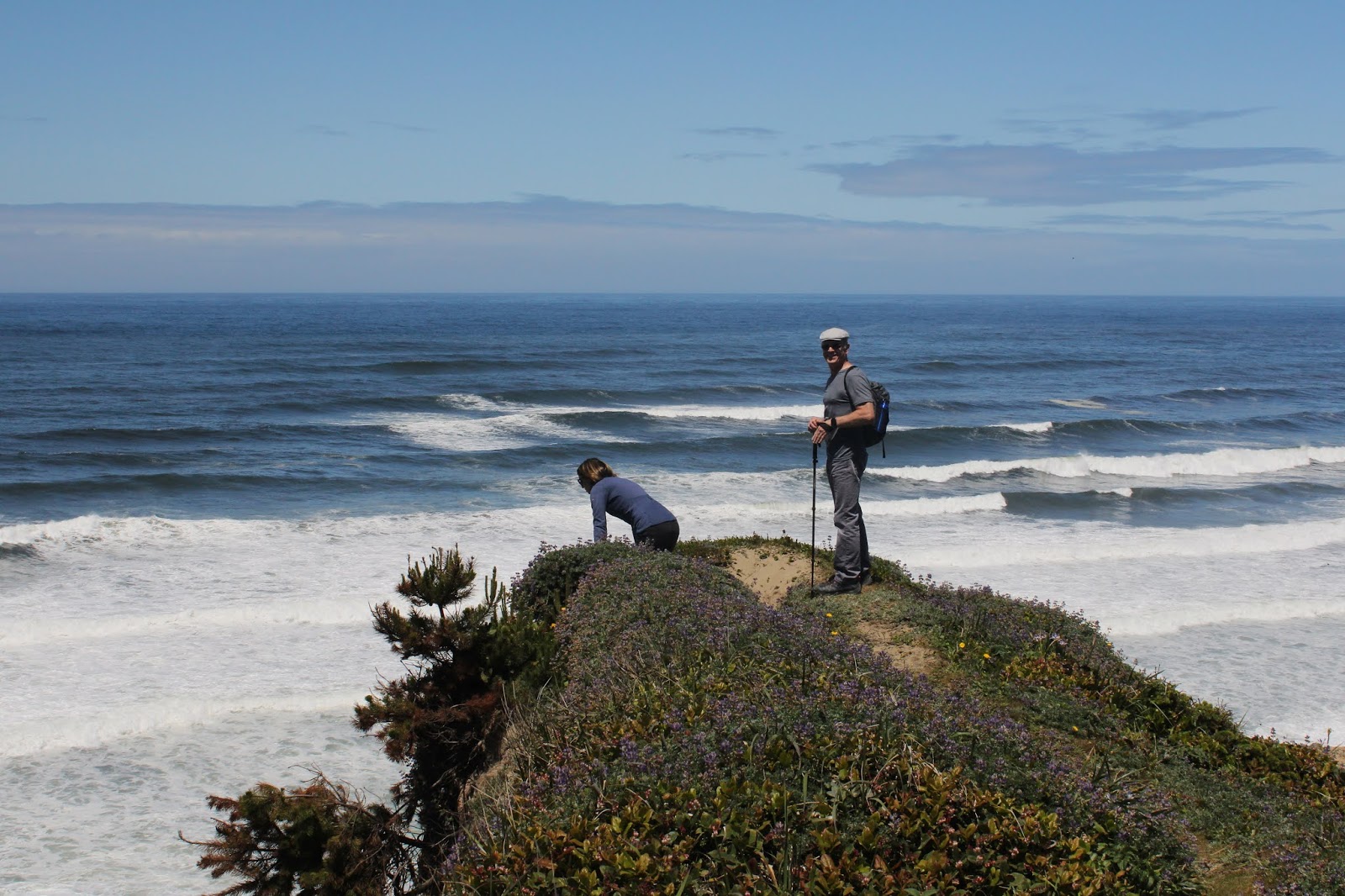
One hiker is warier than the other

While I profusely apologized to Anne for the scratchy bushwhack thing, she said that if that was the worst thing that happened to her, then this had been a good day. Deciding to push my luck, I whipped out Anne's weighty tome of hiking don't-do's and found out that eating ice cream was not included in that interminable screed. So we did that very thing in Bandon to close off what had been an awesome 9.7 mile hike with some awesome friends.

Best View Ever

For more photos of this hike, please visit the Flickr album.

Friday, June 7, 2019

Oregon Coast Trail (Thomas Creek Bridge to Lone Ranch Beach)

"You're in charge, Richard!" Bwah-hah-hah, oh how I love to get the mantle of leadership conferred on me. It's like being given free rein to come up with a Richard Hike. Of course, my three comrades John, Katchan, and Edwin were all up to the task and to be honest, a Richard Hike is much easier than a John, Katchan, or Edwin hike, anyway.

A carpet of false lily-of-the-valley
This was the first day of a weekend campout at Harris State Beach, located near the town of Brookings, Oregon. Since the consensus was that I was the only one even remotely familiar with this area, I could and should choose the hikes. Feeling some responsibility for coming up with a challenging hike, I settled on a rugged section of the Oregon Coast Trail that ran through the southern half of Samuel Boardman State Scenic Corridor. Basically, the Oregon Coast Trail lives and breathes in the narrow strip of land between Highway 101 and the ocean. Despite the narrowness, the coast here is nothing but scenic with a plethora of viewpoints and coastal landmarks to gawk at. And when not gawking at landmarks, we could simply enjoy the lush coastal jungle growing on near vertical slopes that are the rugged line of demarcation where the Pacific Ocean begins and Oregon abruptly ends.

Tangled tendrils on a coastal manroot
The plan was to begin at Thomas Creek Bridge, a highway bridge spanning the narrow canyon of Thomas Creek. At 271 feet above creek level, Thomas Creek Bridge is noteworthy because it is Oregon's highest bridge. It is hard to get a good look at the bridge even on a good day, but it's completely impossible when the viewpoint is closed because of construction, which was the case on the day of our hike. 

John takes the scramble trail down to the Oregon Coast Trail


No worries, even though the viewpoint and trailhead were closed, we followed a scramble path (with some use of hands required) that dropped precipitously to the Oregon Coast Trail contouring through a dark and shady forest. The Oregon Coast Trail in Samuel Boardman Park is notoriously rugged as it constantly goes up and down but rarely level, and suffice to say we got plenty of exercise within the first several miles.

Katchan stops for a photo-op
As we were maybe just starting to get habituated with the forest, the forest suddenly stopped and we found ourselves perched high above a narrow defile, with surf crashing against the rocks well below our trailside aerie. It would be just a few horizontal steps to get to the beach but it'd be roughly about a thousand foot drop to get there so we decided it'd be best to stay on the trail. 

A patch of lupines perch several
hundred feet above the ocean
As the trail descended through trees and salal, stunted and shaped into phantasmagorical forms by the constant sea breeze, we enjoyed an awesome view of the Oregon coast stretching north. Massive cliffs and steep slopes, all densely forested, plunged more daringly than a courtesan's neckline at a royal ball. Below the cliffs were some incredibly narrow but scenic beaches which would be amazing to explore, were it not for the nigh impossible task of getting down to them. Scattered randomly offshore were a myriad of islands big and small, collectively dotting the azure sea like a rash of black measles on a Smurf.

Douglas iris was all along the route
On the trail, Douglas irises were blooming in veined purple profusion and the two hikers with cameras (Katchan and your merry blogster) soon found themselves lagging behind the two without. While the trail steadily lost hard won elevation, we were not going all the way down to the beaches below. Instead, we leveled out at beautiful and fascinating Indian Sands.

Sand dunes at Indian Sands
Indian Sands are a series of sand dunes but what makes them unique from other Oregon sand dunes is the fact they are perched atop a cliff a couple hundred feet or so above the sea. I'm not sure what geological or meteorological mechanism creates and replenishes these dunes but who cares, they are still way cool. 

The rocky bowl at Indian Sands
If the dunes weren't attraction enough, there is a spectacular rocky bowl complete with arch, waterfall, and ocean pulsing through the arch and into the bowl. This whole little scene is ringed with dense and close-to-the-ground patches of purple lupine and bright red Indian paintbrush plants. Just wow, already.

The Oregon Coast Trail was not always this well defined
After an appreciative view-soak at Indian Sands, we bushwhacked uphill back to the Oregon Coast Trail. After the tedious bushwhack, it was a happy occasion to attain the nicely maintained trail, From there, it was another forest walk on a trail lined with lush ferns to an egress at the road leading to Whaleshead State Beach. Unfortunately for us, we could see the Oregon Coast "Trail" continuing on the other side the road.

Yes, this is really the Oregon Coast Trail
Why did the hikers cross the road? Why, to search for the trail, of course. The Oregon Coast Trail was not at all nicely maintained here and in fact, I'm speculating it had not seen a weed whacker at any time since the invention of weed whackers. At any rate, we discerned the route by hiking in brush that was marginally not as dense as the surrounding vegetation. Obviously, most hikers walk down the road to get to the beach. Our reward for this brush beater of a trail was a nice lunch on real picnic tables in the park.

Some of that Whaleshead Beach scenery
The formal Oregon Coast Trail route calls for a wade across shallow Whaleshead Creek fanning out across the beach strand, followed by a mad quad-straining charge up the same hill we had just struggled to come down, and on the same "quality" of trail, too. I told the guys I knew a much better way and even they all should know better, they agreed to follow me.

Tidepools aplenty on Whaleshead Beach

It was a two mile walk on the scenic beach and we explored the many tide pools full of mussels, barnacles, and starfish that had become accessible during low tide. But when the sandy shoreline ended where a creek tumbled over some rocks and boulders to reach the beach terminus, we had to scramble up a cliff, with heavy use of hands required, to gain a faint path on the grassy slopes.

This section of trail was challenging, to say the least
Now, I'd done this trail before and it always had been sketchy at best. In fact, at the upper end, there is a sign discouraging hikers from taking that trail down because of the level of difficulty. On this day, the trail had become even more sketchy, to the point of being nearly nonexistent. Fortunately, there were old trail markers we could follow and if we couldn't find the next marker, sometimes we'd get lucky and find a faint piece of the old trail. As if this degree of difficulty wasn't challenging enough, the route was incredibly steep. The funny thing is, as we worked (emphasis on "worked") our way up, I daresay we all had joyous grins of enjoyment on our faces. On the plus side, the views of Whaleshead Beach and House Rock, a house-shaped island in the ocean, were eminently enjoyable, especially when bent over with hands on knees, trying to restore overworked lungs back to anything resembling a normal respiratory rate.

Back on a civilized trail
Once we enjoyed a felicitous reunion with the blessedly civilized Oregon Coast Trail, it was a relatively level hike through a dark forest, way darker than normal, to the House Rock Overlook where we took a well-deserved break from hiking. From there it was back down through a thinning forest to open grassy slopes on windblown Cape Ferrello.

Windy Cape Ferrello
Did I mention Cape Ferrello was windy? If not, just let me tell you it was breezier than the inside of a wind tunnel at Boeing. All the grass on the cape was laying down sideways and any plant that was not a grass specie did not grow any taller than an inch high. We all put on jackets and layers and it didn't matter, the cold wind forced its way through each and every microfiber as if we weren't wearing any protective clothing at all. Having duly whined, though, the view to the rocky cape from our clifftop perch was pretty cool and was worth battling the buffeting air currents for.

Blackberry was in full flower near Lone Ranch Beach
Instead of backtracking back to the Oregon Coast Trail, we rounded the cape and then performed a tedious bushwhack (grasswhack?) up a windblown grassy slope to where we correctly surmised the trail would lie. Ah, a real trail is so much easier than rough ground, especially when it gently switchbacks down through dense patches of blackberry brambles being tended to by fuzzy bumblebees. As we descended, we enjoyed the panorama of arcing Lone Ranch Beach with a populous congregation of islands afloat in the bay. We also really enjoyed the view because our arrival at Lone Ranch Beach would bring this long and rugged trek to a close. A short boardwalk, in the literal sense of the word, for the boardwalk was just an actual board spanning Lone Ranch Creek, closed this hike out and there was much rejoicing.

A small creek tumbles across the trail
So, this tough 9.4 mile hike was an epic Oregon coast sampler, but not the ultimate Oregon coast sampler. For that, we drove into Brookings for Mexican food and craft beer. Now, THAT was the ultimate Oregon coast sampler!

Oh, what a tangled web of branches we weave!
For more pictures of this epic coastal hike, please visit the Flickr album.


Saturday, September 16, 2017

Dellenback Dunes (Hall Lake version)

My life is not complete until I purchase a shoulder-season sleeping bag with all of these features: 850-fill water-resistant goose down, 15-dernier ripstop nylon shell, variable baffle spacing locates, an insulated yoke to prevent heat loss at the shoulders, and an internal anti-snag zipper strip combine to prevent that awkward moment when your trap yourself inside your own sleeping bag. And that is just one little item on my very large list of stuff that I absolutely have to have.

Why we hike!
Unfortunately, reality butts heads with wants, like two rutting bighorn sheep crashing into each other on the high mountain ridge of I'm-Not-Working-Anymore. So, despite my best efforts to retire and stop working altogether, I find myself gainfully employed on a part-time basis because I have full-time needs. And despite my best efforts to live the remainder of my life as a reclusive hermit, I now find I must interact with co-workers too, darn it. And despite my best efforts to introduce my colleagues to the wonderful little avocation of hiking, my sofa-bound workmates politely decline my invitations. Until now, that is. Newly hired Jay has recently come to Roseburg by way of Massachusetts and India, and when he opined he wanted to go hiking with me, I happily seized the opportunity to take him on a hike before he actually read my blog.

An incoming fog bank was cause for concern
Normally, my go-to hike for newbies is the Rogue River Trail but the worst fire season ever was still smoking out southern Oregon, so it was off to the coast for cleaner and clearer air. Good news had arrived in the form of light rain during the week prior, and all of western Oregon rejoiced at the tamping down of the fires. However, there was no blue sky waiting for Jay and I at the John Dellenback Dunes Trailhead, just a bleak overcast of gray clouds. Still, that was better than the bleak overcast of dirty brown clouds of acrid smoke and ash that we had been contending with for the last six weeks.

Portal to Dellenback Dunes


The trail to the dunes is fairly civilized at the start, heading through coastal woods after crossing Eel Creek on a picturesque wooden bridge. This was mid-September, so the coastal huckleberries were in season and we partook as we walked through the damp woods. Eventually, the well-maintained path morphed into a sandy track and Jay was quite taken with the smooth red limbs of manzanita, as the unique shrub does not grow in Massachusetts or India, apparently.

Singing "The first hill is the steepest..."
Once the trail spit us out onto Dellenback Dunes proper, we quickly walked uphill in soft sand to the top of the "Great Dune". After admiring the view of the vast sandy expanse stretching out towards the ocean, we discussed our hiking options. The normal route is to hike on the "Great Dune" to the beach trail, follow the beach to Tenmile Creek, and then bushwhack back for an 8'ish mile loop. For a shorter distance, we could walk to the beach and back for a 6'ish mile and relatively easy hike. Then there was the wildly up and downer to Hall Lake. While short in mileage, this little hike is mighty in climbing up and down some rather large mountains of sand. Jay opted for the last route, so short and sweet our hike would be.

Jay finds out downhill in soft sand is better than uphill


As we dropped down the "Great Dune", I remarked to Jay this would be easy! But what goes down, must come up and we soon quit talking to each other as we struggled up a large sand alp, the soft sand making it hard to work our way up to the top.  Once at the dune summit, we again admired the views while waiting for our respiration rate to return to normal as our heaving lungs worked overtime to catch up. Only 4 more dunes to go!


Grubs live int the sand
While going up and down a successive series of giant sand dunes, I noticed small bug tracks weaving hither and yon on the sand. Once such track ended abruptly so I dropped to my knees and dug carefully around the end point. I was rewarded for my efforts when a grub rolled into my hands.  Mystery solved! I had always wondered creature had made those tracks.

Seed beetles were out for a hike, too
Another mystery was solved when I spotted a red-and-black seed beetle crawling on the sand. For years, I had observed a particular set of tracks that consisted of short little feet, like a centipede, with a tail-dragging mark in between. It always looked to me like a lizard track, except there are no lizards in these sand dunes. Well, turns out that tail-drag is the mark that a beetle butt makes when it's dragged through the sand. The next great mystery concerns why the beetle is out there in the first place, there's not much out there in the way of vegetation apart from beachgrass.

The dearly departed
One of the highlights of this route is the ghost forest atop the third dune we climbed over. At one point, there had been a thriving forest of trees growing here. My theory is that the sand encroached the trees and smothered the life out of them. At any rate, all that is left of the trees is a stand of ghostly white snags etched against the skyline. The sand is littered with tree parts and before long, the snags will crumble into little itty-bitty pieces and the ghost forest will be no more. The wind soughing through the trees imparted a forlorn air about the place. Jay and I walked reverently past the tree graveyard, paying utmost respect to the deceased.

Let's walk up that!
The fifth dune was the toughest one, seemingly more sandy wall than dune. We angled across the face of it because going up would never work. As it was, it was two steps up and one down and if you stopped to take a picture, admire the view, or simply rest, you were liable to lose all that hard-won elevation as the sand collapsed under your feet.

Hall Lake
Our reward for this dune, though, was a nice overlook of scenic Hall Lake, its dark waters half in the sandy dunes and the other half in densely wooded forest. As we had been walking we had noticed a large bank of clouds and fog  rolling in and just before we got to the lake, the fog arrived, carried in by a stout breeze. The temperature dropped and we put on some extra clothing as we shivered while eating lunch.

The fog paid a brief visit
We didn't tarry because of the chill breeze, so after lunch, we headed back to the crest of the large dune we had hiked in on. The wind was brisk but on the positive side, it blew that nasty fog bank all the way to Kansas, and it became a sunny day all of a sudden.


Free skin exfoliation at Dellenback Dunes
This particular dune was acutely defined on its crest and the wind was blowing sand over it, blurring the sharp lines of the dune. I had shorts on and my shins can painfully testify to the sandblasting properties of windblown sand. Once we dropped off the dune, we were sheltered from the wind and it became what legitimately could be called a warm day.


There were numerous little ponds in the dunes still
I was trying to get to the flats behind the deflation plain forest but it seemed no matter how much we angled towards the flats, deep canyons and brushy oases forced us away from the sandy flats. So, once we got out of that mess, we simply followed guide posts back to the "Great Dune". And from there, it was back to our car via the sandy track.


Boys will be boys
Before this hike, my boss had sent me a text message, warning me that I had better return Jay in the same relative condition I had found him in. So, I texted her back (after the hike) that Search-and-Rescue were optimistic they could find him before nightfall. But the truth of the matter is I didn't harm him, unless you count shoes full of sand as being harmful.


Tiger beetles were flitting all over the sands
For more pictures of this hike, please visit the Flickr album.


Saturday, May 7, 2016

Blacklock Point

My last hike in the Owyhee Uplands was all about dry sagebrush and arid terrain. A week later, I'm at Blacklock Point in a veritable coastal jungle bursting with rampant and unrestrained greenery. Talk about extremes! However, the comparison to the Oregon desert is the only thing extreme about Blacklock Point. The trail is user-friendly, mostly flat, and the view north to Bandon from a clifftop perch is my favorite view in all of Oregon. So why where there only 5 of us at the trailhead on a semi-sunny morning? That's because all the stay-at-homes are slackers and that's OK because we got the better deal, enjoying a fine spring morning on the Oregon coast.

One of 1,012,058,216 rhododendrons seen on this hike

From the start at quiet Cape Blanco Airport, it was obvious this was rhododendron time at the coast. The trail was a narrow alley carved through 10 foot high bushes all flecked with pink from the showy blooms. Rhododendron petals carpeted the trail and most of the winter and early spring mud puddles that customarily swamp the trail were dried up. We only had to take a dry-footed detour around just one or two of the seasonal watering holes.
Wind, personified

The hike to Blacklock Point from the Cape Blanco Airport is short and sweet and we arrived there in short order. The cliff-edge trail sports great views of the wild coast stretching out to the Sixes River and Cape Blanco. And of course there is Blacklock Point itself, a rocky pyramid with a chain of small islands extending out into the ocean. It seems like every time I've been here, a strong chilly wind blows and today was no exception. Dave worked his way out to the top of the point while the rest of us dithered about where to eat lunch, the consensus being nobody wanted eat lunch in the frigid breeze.

It's a Richard Hike even when it's not
Rheo, who was leading this hike led us on a bushwhack venture down into a small ravine with an unseen creek lurking in the waist-high brush. She warned us to watch our step but that didn't stop me from disappearing into the creek's cleft hidden in the tall brush. Once the creek crossing was safely navigated by all but yours truly, it was a rather rigorous scramble up a steep slope covered with thick brush and trees.

Bushwhacking makes us happy!
Caryn and I were lagging behind the others and Rheo called down to us, telling us to take a path to the left. We did and boy, was it ever the wrong way to go! The two of us slithered and crept through a thick tangle of small trees wanting to pluck our eyes out with their bony claws. With a sarcastic "Thanks, Rheo!", we rejoined our comrades on a cliffy viewpoint with a nice overlook of Blacklock Point. Arguably, the scratchy bushwhack could qualify this hike as a Richard Hike, but hey, I'm the victim here, this time.

Tunnel of doom
We continued onward on the Oregon Coast Trail where I led our little group to a hidden viewpoint with what may be my favorite view in all of Oregon. However, getting there was all the "fun". The path to the viewpoint, in years past, has always been brushy and has always required a rather rigorous bushwhack. However, the thick coastal scrub has pretty much claimed the old path nowadays so I led my innocents on a different route that still left scratches. This was the Richard Hike portion of this little venture and I accept full culpability.

The best view ever!


The view north from this viewpoint toward Bandon is superb with a row of cliffs resembling an ancient colonnade marching off into the misty distance. The sun was sort of out and the fog was sort of in and the sight of the endless procession of waves crashing onto the narrow beach was awesome. A small creek plunged off the cliff here, and we all admired the resulting waterfall. Well worth the blood, sweat, and tears to get here, in my opinion.

Paintbrush hanging out with the lupines

After lunch, Dave and I continued on for a longer loop hike while the others headed back to the car. The Oregon Coast Trail ambled through a dense forest comprised of spruce with a healthy undergrowth of salal and rhododendron. Periodic openings allowed us the odd view from the cliffs every now and then.


Salal was also in bloom


We went as far as Floras Lake and by this time, a gray cloud cover had scudded in, there would be no more sun the rest of the day. The rest of the hike was a pleasant amble on an old road bed with one airport runway crossing interspersed. All in all, a nice hike on an old friend of a hiking trail.

Dave and Caryn scramble down Blacklock Point
For more pictures of this hike, please visit the Flickr album.