Showing posts with label oregon coast. Show all posts

Tuesday, April 5, 2022

Shore Acres/Sunset Bay State Parks


Last time I was here at Sunset Bay during a high surf event, I wound up running for my life when a big wave tried to eat me. However, at low tide you do have a little bit more time to recognize a man-hungry wave roaring in from the sea, and thereby avoid that ungainly panicked sprint to high ground and safety.

A ferny trail took us atop the coastal bluffs at Sunset Bay

I'm happy to report no danger-filled episode took place on this outing in the Cape Arago area. The sea roared and seethed well offshore and politely stayed away from fragile hikers and beachgoers at Sunset Bay. However, the nearby rocky islands were receiving a royal and personal pummeling from King Neptune himself. High tide was several hours away yet, so hiking buddy Dianne and I felt quite safe as we commenced hiking up to the forested coastal high ground overlooking the bay.

Qochyax Island guards the gates

The first little highlight of this hike occurred when we grabbed the unofficial path to Qochyax Island, forever standing guard (and taking serious surf abuse, too) at the entrance to Sunset Bay. The island was bare and rocky, the only adornment a sad little stand of long-dead trees that imparted a forlorn and mangy kind of air to the island eternally standing resolute and stalwart in the middle of an unappreciative ocean. 

What's that skunky smell?

The hike was mostly about the waves but not entirely. The coastal forests were lush and green and spring was on the way in form of pungent skunk cabbage flowers (the odor of which I unjustly blamed Dianne for), dangling bells of salal blooms, and blossoming heads of coltsfoot calling in bees and butterflies alike. Dianne is as camera-afflicted and addicted as I am, so our hiking pace was properly slow and contemplative as we clicked the day away.

Dianne unhappily hikes in my elements

On the way to a coastal vantage point, the trail became quite muddy and boots were tasked in keeping us upright and from sinking up to neck level in cold muddy goo. I enjoyed this part of the hike but Dianne did not. Enterprising hikers had fashioned a primitive walkway by tossing a series of branches into the mire. The crude walkway was slipperier than a boogery eel but it did the trick as we did not sink higher than an ankle or two.
Boom!

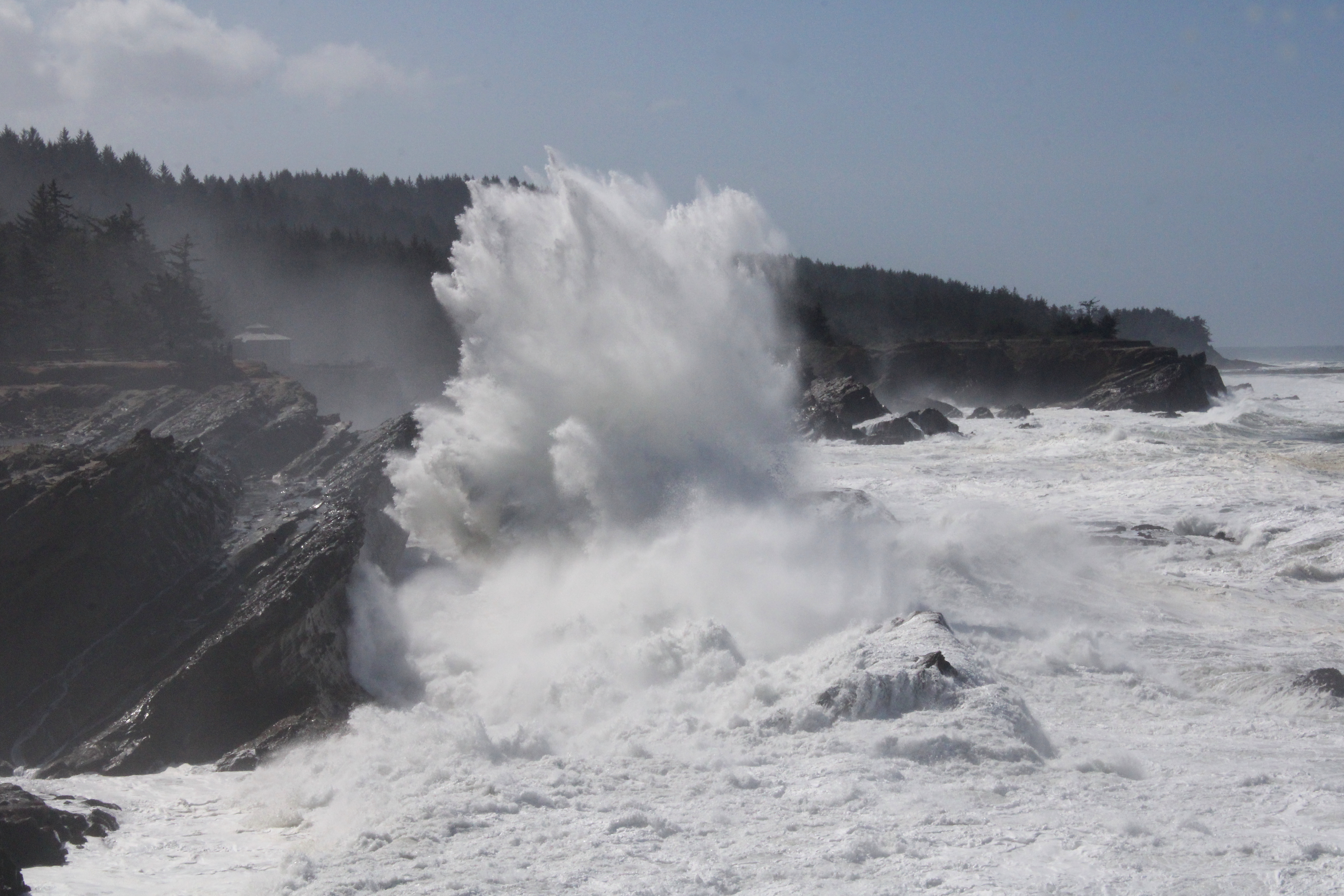
Once we entered Shore Acres State Park proper, the waves began to really put on a show. Here, the waves collided with exposed sedimentary layers inclined at a uniform 45 degrees by ancient seismic processes. When an unstoppable force meets an immovable object, a huge amount of angry energy gets released in the form of massive white-watered explosions. As we walked, walls of white water rose 20 feet or so above us, while the beautiful clear day was rent with a roaring cannonading blast of sound and fury.

The waves were spectacular as the tide came in

I daresay we tarried there quite a bit, happy to be close (but not too close) to the raging chaos. Our next stop for the wave fun was at the observation area at Shore Acres. Here we could see from a short distance, the same waves that we had earlier been craning our necks skyward at in order to comprehend the full breadth and scope. From the cliffside vantage point, we could see and appreciate the awesome perspective of massive wave in comparison to the little ants that were actually people doing what we had been doing just a short while prior.

Sound and aqueous fury

After sideswiping idyllic Simpson Beach, not quite as idyllic on a raging high-surf day, we grabbed a series of use trails that led us to the edge of several bluffs that were a little bit on the wild side, as they don't see as many people as Sunset Bay and Shore Acres do. Same old gigantic waves though and we spent another fair amount of time watching the perpetual war between sea and land. Plus, we had a good view of the Oregon coast to the north getting hammered over and over again by the relentless ocean. We tried to find a short-cut or bushwhack route back to the proper trail but the coastal shrubbery was too thick to make our way through. Defeated by plants, we hiked out on the same old trail we had come in on, our heads hanging in shame.

Not your basic native plant

On the way back, we swung by the formal gardens at Shore Acres and enjoyed the geometric contours of the formal garden and bricked paths, while appreciating the cultured beauty of the flowering daffodils and azaleas. Here, we rejoined with Connie who had been hanging out in the gardens all day while Dianne and I hiked along the coast.

Coltsfoot kept the bees and butterflies entertained

This had to be the slowest hike ever. Basically, we hiked 7 miles and it took us nearly 5 1/2 hours, a pace of 46 minutes per mile. To put it in more understandable terms, we walked slower than a narcoleptic sloth, slower than a Jeep with a broken transmission (personal experience, here), slower than a teenager getting ready to mow the lawn, etc. But can you blame us? There was just too much to savor and appreciate on this fine day.

Things calmed down when the tide began receding

For more photos of this hike, please visit the Flickr album.

Saturday, August 21, 2021

Siltcoos Lake


It's a mad, mad, mad world out there, full of yelling, shouting, fist shaking, spittle-spitting, and all-caps rage tweets, and that's just my family! The rest of the screaming part of the world is about as warm and fuzzy as a cave full of buzzing rattlesnakes too. Hiking has always been an escape from that particular riled-up fire ant nest of venom and vitriol but this year, it's been pretty hard to hike. The mountains have been basically off limits because of numerous forest fires and besides which, health problems have slowed me up a bit. Even the reliable coast has been hiker-unfriendly, with valleys and coast cuddling under a blanket of air foul, smoky, and acrid. But on the Siltcoos Lake Trail on a blessedly clear day, it was a joyful healing time spent in "peace like a forest".

Peace like a forest

This particular hike was a Friends of the Umpqua Hiking Club operation and about 10 like-minded friends set foot on the Siltcoos Lake Trail on a pleasant Saturday mid-morning. Almost immediately, you could hear a collective sigh of relief and grateful appreciation from all participants. The path headed uphill through a dense forest mostly comprised of tall conifers. At ground level, it was luxuriously cool and shady, and leaves in the rampant vegetation bobbed gently up and down with the slightest provocation of the slightest stirring of air. Small birds were mostly heard as they twittered and flittered through the nearly impenetrable greenery and we all hummed "Kumbaya" in accompaniment.

Fairybell fruits were a common sight

This time of year lies in that amorphous seasonal netherworld lurking between late summer and early autumn (summumn?). Didn't see any colored leaves but fairybell plants were sporting bright orange fruits that caught the attention of hikers and cameras alike. I don't think the fruits are toxic but they are probably tasteless and/or unpalatable as my ex-wife's cooking so I just left them where they dangled, especially since I wasn't sure if they were indeed toxic. Tastier and definitely not toxic, were vibrant red thimbleberries and yes I did indulge.

Conks endeavor to recycle a dead tree

Our little world under the forest canopy was dark green (it was deeply shaded, after all) and it stood to reason that the perpetually decaying biomass on the forest floor would support a healthy population of mushrooms and other fungi. Seemingly, every color, size, shape, and type were represented, ranging from diminutive parasols sprouting in a bed of moss to tough tinder fungus reposing in pine needle duff to woody conks staking their claim on dead tree trunks. Internally I labeled all the fungal denizens as "poisonous" and thereby resisted the temptation to partake thereof. I'm no mushroom expert so it's just safer that way.

Just a beautiful trail all day long

With so many things to photograph, it wasn't long before I assumed my customary place at the rear of the hiking queue. And before long, I found myself hiking all alone in the woods. A moment of consternation came when the trail intersected the loop portion of the hike. Do I go north or south? Which way did everybody else go? Not having the answers to those questions, I recalled from my last hike here that hiking out on the south trail was really steep and taxing so I opted to go down the south trail this time out. Good move!

C'mon sun, dispel those dark clouds!

Enjoying the downhill hiking, I soon caught up to Ceresse and the two of us hiked in easy companionship at our usual turtle'ish speed. When we arrived at the southern backpacking campsites next to the lake, our comrades had already eaten their lunch and were wrapping up dessert. As our friends impatiently waited, held hostage by Ceresse and I leisurely eating our lunch, we all enjoyed a nice view of Siltcoos Lake from the campsite. Although, the sky was covered up by a layer of ominously dark clouds. It wasn't going to rain, was it?

Gnome plant, macro version

Near the campsite were a couple of saprophytic plants, not to be confused with mushrooms or fungi. A small patch of pink fleshy-colored gnome plants and pale white vampiric-looking Indian pipe vied for ownership of the same fertile patch of earth. Since we spotted both sets of specimens growing next to the trail, we'll call it a draw. Saprophytic plants lack chlorophyll to make nutrients from sunlight, so they partner with certain fungi to parasitize on certain plants, like salal. Professor O'Neill expounded on these amazing plant specimens while his captive pupils fidgeted restlessly, hoping the bell would ring soon.  

It sure looked like it might rain

After lunch, we made the short walk over to the northern set of backpacking campsites. I really must come and spend a weekend here, the hike would be short but those relatively luxurious campsites are an attraction in and of themselves. The north campsites provide better access (and views) to Siltcoos Lake and we stopped for a moment to gawk once again at the lakeside scenery. The clouds had gotten darker and despite an optimistic weather forecast, the foreboding dark cloud cover made us wonder once again if rain was indeed in the offing. 

Logging scar from yesteryear

The hike out on the northern loop trail was not bad at all, the grade was gentle and easy on the quads, unlike its southern loop sibling. The sun came out and dispersed most of the clouds and some sunlight filtered down to trail level. The mottled light in the forest was entrancing and we could only imagine what it had been like before the original old growth forest had been logged back in the day. Massive stumps from the former forest still bore the scars of the cuts where buckboards had been inserted to support a burly lumberjack on either end.  

Everybody should hike like a slug!

It's a shame this hike is so short because its tranquil forest vibe left us replenished and sated, but yet wanting more of the same. I'd gladly trade in uncivilization for the forest and spend the remainder of my days there, but then I'd have to give up watching concerts and soccer games. Besides which, the deer would eventually get me.

Hedge nettle, up close and personal

For more photos of this hike, please visit the Flickr album.

Saturday, November 28, 2020

South Slough


South Slough has definitely grown on me. For years I'd turned up my nose at its little five(ish) mile loop but after enjoying the incredibly lush forests, well groomed trails, and awesome slough scenery it's safe to say I've been a convert for several years now. So, when the Friends of the Umpqua penciled the reserve (the wordy formal name is South Slough National Estuarine Research Reserve) onto their calendar, I figured I'd join in, especially since a hike is so much more relaxing when one is not in charge of the outing.

A little worse for the wear but still green

It was late November, right in the middle of winter's icy commencement but you'd never know it by hiking on the South Slough trails. While thimbleberry and deer fern were well in the process of shutting down for the winter, most of the other predominant vegetation such as moss, ferns, salal, and rhododendron were very much from the green arc of the color wheel. Accordingly, green was still the dominant color along the trail and if you ignored the yellowing thimbleberry leaves, then it looked and felt a lot like spring, especially since the sun was out.

A log surrenders to the inevitable

The hike started pleasantly enough for it went downhill for the first couple of miles or so. Of course, we would pay for all that nice downhill goodness, but why worry about it now? Let's just live in the moment and enjoy the easy hiking while we can! As we angled down to the slough, directionally and relatively unimaginatively named North Creek birthed into existence when hundreds of rivulets and rills trickling down the slough's rim braided together into one stream. The babbling of creek and comrades both was a constant as we hiked down the gently sloping and heavily forested creek canyon.   

Unclear on the concept of camouflage 

The well-maintained trail was quite civilized, so much so that I began a desperate search for a fallen tree to climb over, a landslide to scramble across, or a bear to growl at; anything else to break up the overt niceness of the path. The only thing I could find that added an element of wildness to the hike was a faint side trail that led down to an overlook of the North Creek arm of South Slough (labeled as Sloughside Marsh on the printable trail map). The partial view was nice and the thick brush simultaneously scratched my arms, face, legs, and Richard-hike itch. Plus, there were some bright red coral fungi sprouting out of the damp earth, looking more at home in a Martian rock garden than on a Pacific Northwest forest floor.

Bridge crossing between marshes Sloughside and Rhodes 

Normally, the brackish waters of the slough just idly pool by with no discernible movement. However on this day, the tide was clearly and visibly waning as the slough slowly emptied its water into Coos Bay, unseen and several miles to the north. The dropping water level exposed mud flats myopically blinking their light-sensitive eyes in the bright morning sun. After crossing a gracefully arching bridge spanning the gap between marshes Sloughside and Rhodes, we reached a five-way trail junction which led to at least five choices of where to hike next.

Old pilings gradually disappear into the slough

We ended up hiking four out of the five trail offerings which is at least a B on a surprise quiz in calculus class. The Sloughside Trail, as its name suggests, follows the slough on a trail atop an old eroding and crumbling dike. Best to hike it while it still exists, kids! The view atop the old berm is epic though, as you stare downstream in the general direction of Coos Bay, which the slough empties into or fills from, depending on whether the tide is incoming or outgoing. 

It's called Tunnel Trail because...?

After eating lunch on some wooden viewing platforms on the nearby Marsh Edge Trail, we grabbed the Tunnel Trail to begin the work of closing off this loop hike. The path was a wide track flanked by thick shrubbery that arched overhead, mingling and then comingling with thick shrubbery doing the same thing from the other side. The colliding vegetation forms a tunnel for hikers to hike through (and a convenient people-trap for deer to waylay said hikers) which is why it's called the Tunnel Trail.

Welcome to the Kingdom of Sloo

Another lengthy gawk-stop took place at a two-tiered viewing platform whose decks and inter-tree walkways had me wanting to revisit my childhood and play Gobblers and Monkeys all over again. The trail exuded a fantasy novel vibe as we hiked out of a marshy arm of the slough on a mile-long zigzagging boardwalk bisecting the marsh at water level before continuing into the woods. I use the term "water level" loosely because all you could see next to the boardwalk was marsh grass, reeds, and skunk cabbage, all of which seriously encroached the wooden walkway. However, if you were to step off, you would find yourself waist deep in brackish water wondering why you ever did such a thing.

If I don't go in, the deer can't eat me

The hiking had been easy so far but our vehicles were still parked on the slough's rim and since we were at slough level, it was now time to do a little work in the form of hiking uphill. The path inclined through woods lush and green while Hidden Creek (which was not at all very well hidden) trickled musically right next to the trail. But going uphill allows hikers-cum-photographers to use photography of fungi, vegetation, and trail tunnels as the means of masking tiredness engendered by challenging gravity when walking uphill, not that I ever do any of that!

It's just a matter of perspective

For more pictures of this hike, please visit the Flickr album.

Saturday, December 16, 2017

Cape Mountain 12/2017

Normally, it's a simple idea: Hop in the car and drive to the trailhead. However, the drive to Cape Mountain was more like a bus route than a simple put-it-in-gear-and-go. Not too many of my hiking buddies had ever been to Cape Mountain and I had only been once, so this hike was penciled nto the Friends of the Umpqua hike schedule with your merry blogster designated to lead the way. Well, my friends from South Coast Striders wanted to join us so we arranged a pick-up stop in Reedsport; and Lane was coming over from Springfield, so another stop in Florence was arranged. Who knew leading a hike could be so complicated? However, we managed to get all 13 hikers from all their disparate towns and walks of life to the trailhead, in spite of all the logistics. Surely, things would be simpler on the trail.

Moss and trees
Well, maybe not. First we had to hike uphill on the Princess Tasha Trail, then continue on the Scurvy Ridge Trail ("Aargh" he said, in his best scurvy buccaneer pirate voice), take a left on the Berry Creek Trail, followed by a right onto the Nelson Ridge Trail. And all that involved ignoring trail junctions with trails named Lookout, Wapati, Berry Lane, and Cape Mountain. No small wonder we started out with 13 hikers but only wound up with 10 when the hike was over. Spoiler alert: everybody eventually showed up, so all was well.

Eight miles of coastal forest
The scenery is pretty basic at Cape Mountain. Elegantly simple (like the hike leader), the "views" consist of dense growths of, ferns, salal, and moss. If you want to experience 8 miles of deep coastal forest, then this is your hike. Of course, all this simplicity came with a price, as  all of us were soon breathing heavily in short order due to a rather brisk climb to the crest of Scurvy Ridge.

Edwin squashes a hitsi-bitsy spider
A couple of miles in, we arrived at the replica hitsi (a primitive Native American shelter) that had been built as part of an Eagle Scout project. I'm not sure how long ago it had been built but the hitsi is falling into a state of disrepair as it should. since they were never intended to be permanent. Since I was the hike leader, I felt compelled to teach my charges what I know about hitsis, mainly that there is a small spider that inhabits these types of structures: it's known as the hitsi-bitsy spider. Sorry, I just can't help myself and for some reason, I hike alone a lot. 

Spooky branches


The vegetation changed somewhat on the Berry Creek Trail as we exchanged tall conifers for leafless alder trees. We also exchanged the uphill hiking for a trail that lost elevation at a dizzying rate. This was a loop trail and everybody was glad we didn't have to hike back up this path but I kept quiet, knowing we'd have to gain all that elevation again, albeit on a different trail. For stats lovers, the trail lost nearly 1,000 feet in 1.5 miles.

We now head up to Nelson Ridge
Berry Creek was waiting for us at the bottom of the canyon and we all crossed the creek on a log with no pratfalls or mishaps. And then the climbing began. In fact, most of the day was spent walking uphill even though we were hiking a loop route with no net gain or loss in elevation, . Accordingly, after a mild wade across a Berry Creek Fork, the trail charged to the top of Nelson Ridge, angling through a stand of homogeneous trees on the way,

Our lunch time view
There were a series of grassy meadows on top of the broad ridge crest, the grass currently brown and dry in preparation for winter. Fresh elk poop dotted the meadow, so we know a) elk come here to visit and b) the grass is well fertilized. There was also a bench in a meadow with a partial view down to the coast, so we plopped down after checking for elk poop, and ate lunch under a gray sky. 

Seemed like we walked uphill all day long
There used to be a forest road atop Nelson Ridge, and the former roadbed inter-braided with the actual trail and it wasn't always clear which way to go. A few more signs here would be helpful, Forest Service, if you are reading this. The road was actually the Berry Lane Trail and basically continues in the same direction as the Nelson Ridge Trail; so if anybody did take the wrong trail, they'd wind up at the trailhead anyway.

Former road, now doing duty as a trail
When we arrived at the trailhead we were short 3 hikers. Dave showed up about 15 minutes later but Lane and Ceresse were missing in action. Turned out they had come up the Wapati Trail but had to turn back to retrieve some clothing left behind at Berry Creek. It's not what you think either, the clothing item left behind was a sweater or similar accouterment that had been removed to adjust body temperature. It was duly noted that the leaver of clothing was not the same person who was appointed to do the retrieving. I'm not saying which was which, but will also note that Lane's GPS had more miles on it than Ceresse's.

Dense growth made sure we stayed on trail
Anyway, Lane and Ceresse did eventually show up, none the worse for the wear. We went to Florence and stopped at Burritos Los Amigos for some post-hike tongue tacos. That was the simplest thing that happened all day.

A nice view to Sutton Lake
For more pictures of this hike, please visit the Flickr album.


Saturday, September 16, 2017

Dellenback Dunes (Hall Lake version)

My life is not complete until I purchase a shoulder-season sleeping bag with all of these features: 850-fill water-resistant goose down, 15-dernier ripstop nylon shell, variable baffle spacing locates, an insulated yoke to prevent heat loss at the shoulders, and an internal anti-snag zipper strip combine to prevent that awkward moment when your trap yourself inside your own sleeping bag. And that is just one little item on my very large list of stuff that I absolutely have to have.

Why we hike!
Unfortunately, reality butts heads with wants, like two rutting bighorn sheep crashing into each other on the high mountain ridge of I'm-Not-Working-Anymore. So, despite my best efforts to retire and stop working altogether, I find myself gainfully employed on a part-time basis because I have full-time needs. And despite my best efforts to live the remainder of my life as a reclusive hermit, I now find I must interact with co-workers too, darn it. And despite my best efforts to introduce my colleagues to the wonderful little avocation of hiking, my sofa-bound workmates politely decline my invitations. Until now, that is. Newly hired Jay has recently come to Roseburg by way of Massachusetts and India, and when he opined he wanted to go hiking with me, I happily seized the opportunity to take him on a hike before he actually read my blog.

An incoming fog bank was cause for concern
Normally, my go-to hike for newbies is the Rogue River Trail but the worst fire season ever was still smoking out southern Oregon, so it was off to the coast for cleaner and clearer air. Good news had arrived in the form of light rain during the week prior, and all of western Oregon rejoiced at the tamping down of the fires. However, there was no blue sky waiting for Jay and I at the John Dellenback Dunes Trailhead, just a bleak overcast of gray clouds. Still, that was better than the bleak overcast of dirty brown clouds of acrid smoke and ash that we had been contending with for the last six weeks.

Portal to Dellenback Dunes


The trail to the dunes is fairly civilized at the start, heading through coastal woods after crossing Eel Creek on a picturesque wooden bridge. This was mid-September, so the coastal huckleberries were in season and we partook as we walked through the damp woods. Eventually, the well-maintained path morphed into a sandy track and Jay was quite taken with the smooth red limbs of manzanita, as the unique shrub does not grow in Massachusetts or India, apparently.

Singing "The first hill is the steepest..."
Once the trail spit us out onto Dellenback Dunes proper, we quickly walked uphill in soft sand to the top of the "Great Dune". After admiring the view of the vast sandy expanse stretching out towards the ocean, we discussed our hiking options. The normal route is to hike on the "Great Dune" to the beach trail, follow the beach to Tenmile Creek, and then bushwhack back for an 8'ish mile loop. For a shorter distance, we could walk to the beach and back for a 6'ish mile and relatively easy hike. Then there was the wildly up and downer to Hall Lake. While short in mileage, this little hike is mighty in climbing up and down some rather large mountains of sand. Jay opted for the last route, so short and sweet our hike would be.

Jay finds out downhill in soft sand is better than uphill


As we dropped down the "Great Dune", I remarked to Jay this would be easy! But what goes down, must come up and we soon quit talking to each other as we struggled up a large sand alp, the soft sand making it hard to work our way up to the top.  Once at the dune summit, we again admired the views while waiting for our respiration rate to return to normal as our heaving lungs worked overtime to catch up. Only 4 more dunes to go!


Grubs live int the sand
While going up and down a successive series of giant sand dunes, I noticed small bug tracks weaving hither and yon on the sand. Once such track ended abruptly so I dropped to my knees and dug carefully around the end point. I was rewarded for my efforts when a grub rolled into my hands.  Mystery solved! I had always wondered creature had made those tracks.

Seed beetles were out for a hike, too
Another mystery was solved when I spotted a red-and-black seed beetle crawling on the sand. For years, I had observed a particular set of tracks that consisted of short little feet, like a centipede, with a tail-dragging mark in between. It always looked to me like a lizard track, except there are no lizards in these sand dunes. Well, turns out that tail-drag is the mark that a beetle butt makes when it's dragged through the sand. The next great mystery concerns why the beetle is out there in the first place, there's not much out there in the way of vegetation apart from beachgrass.

The dearly departed
One of the highlights of this route is the ghost forest atop the third dune we climbed over. At one point, there had been a thriving forest of trees growing here. My theory is that the sand encroached the trees and smothered the life out of them. At any rate, all that is left of the trees is a stand of ghostly white snags etched against the skyline. The sand is littered with tree parts and before long, the snags will crumble into little itty-bitty pieces and the ghost forest will be no more. The wind soughing through the trees imparted a forlorn air about the place. Jay and I walked reverently past the tree graveyard, paying utmost respect to the deceased.

Let's walk up that!
The fifth dune was the toughest one, seemingly more sandy wall than dune. We angled across the face of it because going up would never work. As it was, it was two steps up and one down and if you stopped to take a picture, admire the view, or simply rest, you were liable to lose all that hard-won elevation as the sand collapsed under your feet.

Hall Lake
Our reward for this dune, though, was a nice overlook of scenic Hall Lake, its dark waters half in the sandy dunes and the other half in densely wooded forest. As we had been walking we had noticed a large bank of clouds and fog  rolling in and just before we got to the lake, the fog arrived, carried in by a stout breeze. The temperature dropped and we put on some extra clothing as we shivered while eating lunch.

The fog paid a brief visit
We didn't tarry because of the chill breeze, so after lunch, we headed back to the crest of the large dune we had hiked in on. The wind was brisk but on the positive side, it blew that nasty fog bank all the way to Kansas, and it became a sunny day all of a sudden.


Free skin exfoliation at Dellenback Dunes
This particular dune was acutely defined on its crest and the wind was blowing sand over it, blurring the sharp lines of the dune. I had shorts on and my shins can painfully testify to the sandblasting properties of windblown sand. Once we dropped off the dune, we were sheltered from the wind and it became what legitimately could be called a warm day.


There were numerous little ponds in the dunes still
I was trying to get to the flats behind the deflation plain forest but it seemed no matter how much we angled towards the flats, deep canyons and brushy oases forced us away from the sandy flats. So, once we got out of that mess, we simply followed guide posts back to the "Great Dune". And from there, it was back to our car via the sandy track.


Boys will be boys
Before this hike, my boss had sent me a text message, warning me that I had better return Jay in the same relative condition I had found him in. So, I texted her back (after the hike) that Search-and-Rescue were optimistic they could find him before nightfall. But the truth of the matter is I didn't harm him, unless you count shoes full of sand as being harmful.


Tiger beetles were flitting all over the sands
For more pictures of this hike, please visit the Flickr album.