Showing posts with label charleston. Show all posts

Tuesday, April 5, 2022

Shore Acres/Sunset Bay State Parks


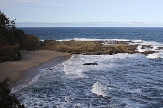
Last time I was here at Sunset Bay during a high surf event, I wound up running for my life when a big wave tried to eat me. However, at low tide you do have a little bit more time to recognize a man-hungry wave roaring in from the sea, and thereby avoid that ungainly panicked sprint to high ground and safety.

A ferny trail took us atop the coastal bluffs at Sunset Bay

I'm happy to report no danger-filled episode took place on this outing in the Cape Arago area. The sea roared and seethed well offshore and politely stayed away from fragile hikers and beachgoers at Sunset Bay. However, the nearby rocky islands were receiving a royal and personal pummeling from King Neptune himself. High tide was several hours away yet, so hiking buddy Dianne and I felt quite safe as we commenced hiking up to the forested coastal high ground overlooking the bay.

Qochyax Island guards the gates

The first little highlight of this hike occurred when we grabbed the unofficial path to Qochyax Island, forever standing guard (and taking serious surf abuse, too) at the entrance to Sunset Bay. The island was bare and rocky, the only adornment a sad little stand of long-dead trees that imparted a forlorn and mangy kind of air to the island eternally standing resolute and stalwart in the middle of an unappreciative ocean. 

What's that skunky smell?

The hike was mostly about the waves but not entirely. The coastal forests were lush and green and spring was on the way in form of pungent skunk cabbage flowers (the odor of which I unjustly blamed Dianne for), dangling bells of salal blooms, and blossoming heads of coltsfoot calling in bees and butterflies alike. Dianne is as camera-afflicted and addicted as I am, so our hiking pace was properly slow and contemplative as we clicked the day away.

Dianne unhappily hikes in my elements

On the way to a coastal vantage point, the trail became quite muddy and boots were tasked in keeping us upright and from sinking up to neck level in cold muddy goo. I enjoyed this part of the hike but Dianne did not. Enterprising hikers had fashioned a primitive walkway by tossing a series of branches into the mire. The crude walkway was slipperier than a boogery eel but it did the trick as we did not sink higher than an ankle or two.
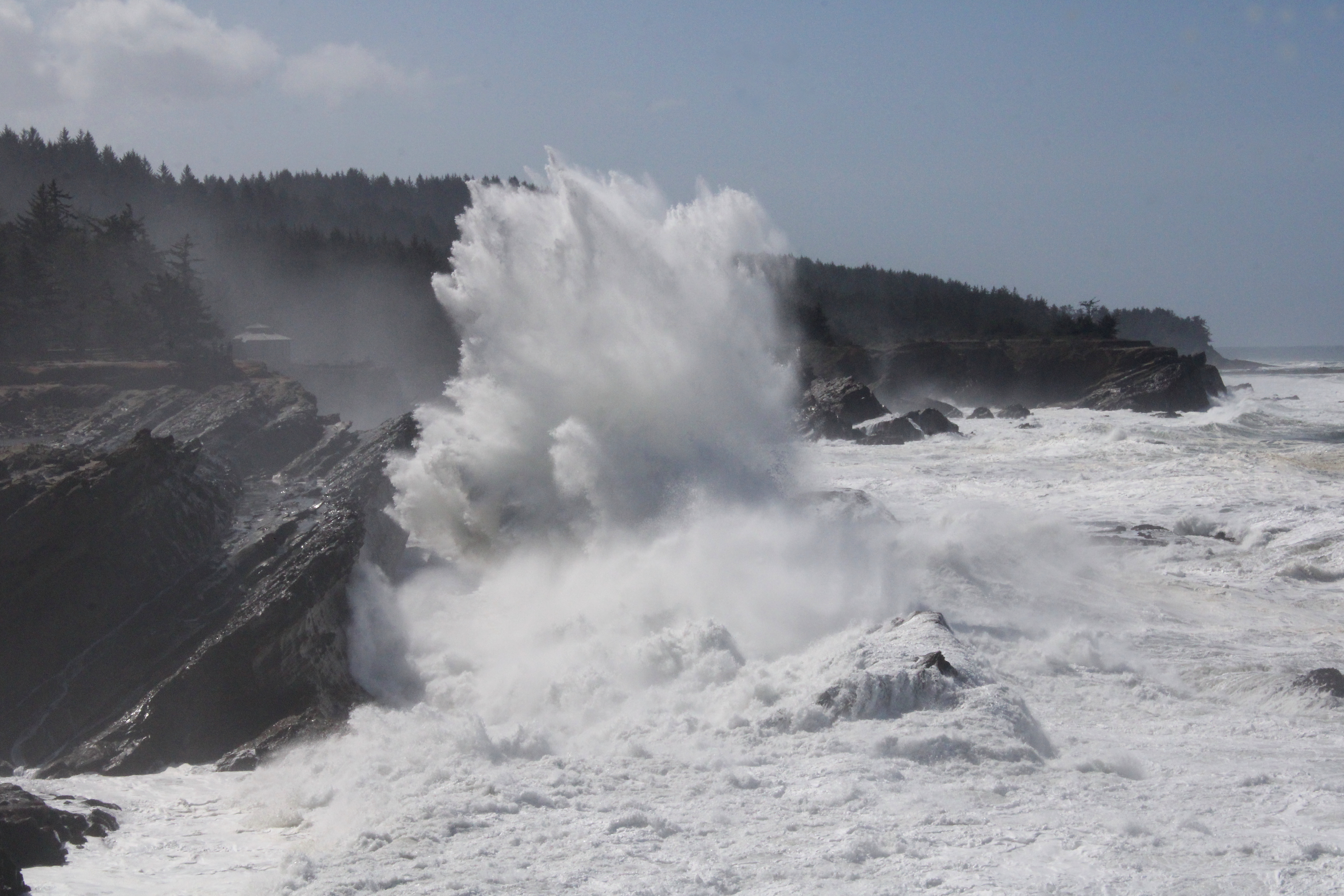
Boom!

Once we entered Shore Acres State Park proper, the waves began to really put on a show. Here, the waves collided with exposed sedimentary layers inclined at a uniform 45 degrees by ancient seismic processes. When an unstoppable force meets an immovable object, a huge amount of angry energy gets released in the form of massive white-watered explosions. As we walked, walls of white water rose 20 feet or so above us, while the beautiful clear day was rent with a roaring cannonading blast of sound and fury.

The waves were spectacular as the tide came in

I daresay we tarried there quite a bit, happy to be close (but not too close) to the raging chaos. Our next stop for the wave fun was at the observation area at Shore Acres. Here we could see from a short distance, the same waves that we had earlier been craning our necks skyward at in order to comprehend the full breadth and scope. From the cliffside vantage point, we could see and appreciate the awesome perspective of massive wave in comparison to the little ants that were actually people doing what we had been doing just a short while prior.

Sound and aqueous fury

After sideswiping idyllic Simpson Beach, not quite as idyllic on a raging high-surf day, we grabbed a series of use trails that led us to the edge of several bluffs that were a little bit on the wild side, as they don't see as many people as Sunset Bay and Shore Acres do. Same old gigantic waves though and we spent another fair amount of time watching the perpetual war between sea and land. Plus, we had a good view of the Oregon coast to the north getting hammered over and over again by the relentless ocean. We tried to find a short-cut or bushwhack route back to the proper trail but the coastal shrubbery was too thick to make our way through. Defeated by plants, we hiked out on the same old trail we had come in on, our heads hanging in shame.

Not your basic native plant

On the way back, we swung by the formal gardens at Shore Acres and enjoyed the geometric contours of the formal garden and bricked paths, while appreciating the cultured beauty of the flowering daffodils and azaleas. Here, we rejoined with Connie who had been hanging out in the gardens all day while Dianne and I hiked along the coast.

Coltsfoot kept the bees and butterflies entertained

This had to be the slowest hike ever. Basically, we hiked 7 miles and it took us nearly 5 1/2 hours, a pace of 46 minutes per mile. To put it in more understandable terms, we walked slower than a narcoleptic sloth, slower than a Jeep with a broken transmission (personal experience, here), slower than a teenager getting ready to mow the lawn, etc. But can you blame us? There was just too much to savor and appreciate on this fine day.

Things calmed down when the tide began receding

For more photos of this hike, please visit the Flickr album.

Saturday, February 5, 2022

Cape Arago


The signal light turned green and I stepped on the gas. In response, my Jeep gave a small shudder and feebly inched forward as fast as a beetle with two legs. After hearing the prognosis from the vehicle's physician, we made the hard decision to authorize a death warrant for our long-term faithful servant. Naturally, I was devastated, so much so that Dollie and I happily purchased a brand new vehicle the very same day. And as I parked my new ride at the trailhead on what will be the first of many such drives, I cheerily sung to myself "I'm a Soul man!" mostly because I'm now the proud owner of a brand new Soul.

Heigh ho, it's hundreds of hikers we go

Hiking and the driving-to thereof, are good for both my soul and Soul, and we parked with a bright cherry red splash at Sunset Bay State Park. This hike to Cape Arago and back was a South Coast Friends of the Umpqua Striders venture, which is what you call a cooperative effort between Friends of the Umpqua and sister hiking club South Coast Striders. The superb weather and scenery ensured a large turnout and all hikers present at the trailhead had plenty of old and new hiking friends with whom to bond with.

A secret beach at low tide

I've hiked in the Cape Arago area when the weather's been nasty and belligerent but on this day, it was downright balmy as the day dawned as sunny and bright as a granddaughter's smile. Lest we get too comfortable though, a chill breeze made sure to ruffle both windbreakers and the ocean's surface and at the start, I didn't see anybody hiking without jackets or extra clothing layers.

Norton Gulch lured some hikers down for a visit

With so many hikers (around 30!) what could possibly go wrong? Plenty really, but the worst of it came when the hikers in front, who did not know the route like us grizzled vets, made a right turn at the first junction and began to head down into Norton Gulch and I figured everybody just wanted to visit the gulch where it meets the sea. They made it about halfway down before stopping and asking me which way we should go. So amusing to see approximately 30 hikers turn around and backtrack on a narrow trail.

Low tide

High tide

It was low tide at the Cape Arago environs, the retreating ocean exposing reefs and rocky shoals to the airy elements. The booming waves at nearby Shore Acres are famed the world over but on this morning, they were barely making a ripple. The wind-driven whitecaps out to sea were larger than the waves lapping against the shore like a thirsty cat at a water dish. However, the ocean patiently bides its time and will once again rampage against the coastal ramparts come high tide.

Panorama of Simpson Reef 

From the gardens and viewpoints at Shore Acres, the coastal trail dipped in and out of the forest, sideswiping iconic landmarks such as Simpson Beach, before winding up at Simpson Reef Overlook. At the viewpoint, tourists and hikers alike can observe the sea lion bacchanalia and debauchery taking place on Shell Island. Replete with fishy smell, all that barking, belching, and farting was kind of like a gathering of through-hikers, but without the backpacks or hiking poles.

The forested path heading up to the Pack Trail

I'm not bragging (oh, but I am!) but I've lost weight lately and where I really notice the difference is when I'm hiking uphill. There is no direct trail from Simpson Reef Overlook to Cape Arago and one can either walk along the road to the cape, or cross the road and take the forested path leading to the Pack Trail. That particular path is a steep one but my lighter new and improved self just charged uphill, nearly as quick as a brand new Soul when the light turns green. Whew, did that ever feel good!

Lunchtime view

The coastal woods, fed by the perpetual fog at the cape, were predictably lush and verdant. The earthen track wound through the trees while numerous clumps of green ferns flanked the footpath. After reaching the Pack Trail, which is actually a gravel road, it was a short drop to Cape Arago herself, where we ate lunch while admiring the view of the sparkling sea and the rugged Oregon coast running to the south.

The sea was a bit more agitated on the way back

On the hike back to the trailhead, high tide was beginning to roll in and the waves were now a lot more entertaining than they had been earlier. We (John, Merle, and I) would see a huge wave break in spectacular explosive fashion, so cameras would be readied and then we'd wait...and wait...and wait for the next large wave. It apparently is a Cape Arago truism that waves are only spectacular when you aren't pointing a camera at them.

Pictorial definition of whitewater

The cool part about going home after the hike is I got to drive my new car all over again. Unfortunately, John and Merle took the occasion to pepper me with technical questions that I did not know the answers to, other than "Yeah, I'm pretty sure it has a motor". My ignorance of all things automotive was further exposed at my first fuel purchase when the attendant asked me to pop the gas tank lid open. Crap, how do I do that? Shaking his head in condescension and with a smirk on his face, the dude showed me where the lever was down on the floor by the seat. Hiking is so much easier!

A wall of solid rock, exposed by the low tide

For more photos of this hike,
please visit the Flickr album.

Monday, December 14, 2020

Cape Arago


It was a King Tide day and at Sunset Bay State Park, Big Creek was unnaturally full of water being forced upstream by the incoming tide. In between waves, I stood next to the creek and took several photographs of the bay, keeping a wary eye on an incoming wave that just kept coming and coming without any inclination of slowing down any time soon. Bye, gotta go! I took off running and all was well until I dropped my hiking pole. Dammit, that wasn't in my carefully crafted plan for escape! I reached down and picked it up, fumbled the pole pick up, then fumbled it again. Finally, got a firm grasp on the sucker and then I really had to move as the surge roared up Big Creek, covering up where I had been standing just seconds before with about 3 to 4 feet of fast moving water. A King Tide is nothing to mess with, dudes and dudettes.

Before

After

King Tide is a non-scientific term for an abnormally high tide. Oregon gets them several times a year and Shore Acres State Park is the perfect locale for experiencing the huge waves that sometimes result. The caveat is that a high surf is also required, because it is entirely possible for a King Tide to fail to generate huge waves and it's also possible for huge waves to manifest without benefit of a King Tide. But on this day, it was the perfect storm in that the King Tide was occurring in conjunction with a heavy surf generated by stormy weather. That was all I needed to wake up before dawn and arrive at Sunset Bay bright and early, trusty camera at the ready.    

A wave really would like to smite some hikers

I was more than happy to hike up on the forested bluffs overlooking the wild ocean after my near escape at Sunset Bay. But I shouldn't have felt that secure, for the waves, after surging into the unyielding cliffs, exploded into white-watered mayhem that often rose twenty feet or so higher than the trail, which was already twenty feet or so higher than the ocean. As I hiked through the woods, I could hear the booming surf cannonading in loud blasts up and down the coast, sounding like the most prolific thunderstorm ever.

A seagull rethinks its flight plan

As the route rounded the rocky cove of Norton Gulch, exposed rocky shoals came into view and the waves breaking over them were an awesome sight. A seagull was patrolling the shoreline and was probably questioning its life choices when one large wave enveloped the bird into its watery embrace, somewhat to my amusement. The constant mist from the waves refracted sunlight which is a non-romantic and very scientific way to say there were lots of rainbows.

Fountain in the Shore Acres garden 

As stated before, Shore Acres is the place to be when the big waves put on a show, what with the strategically sited viewpoint and observation area with easy access. Accordingly, throngs of photographers and videographers were gathered there to get their own personal iconic photos and/or videos of the booming waves. Rather than brandish my sharp elbows to rudely jostle for a place in the photography queue, I figured I'd hike to the secluded bluffs south of Simpson Beach and take some photos from there. However, the trail to the beach was gated shut with a dour-faced park ranger standing by, sternly enforcing the trail-closed edict. Seems that last year during a King Tide event, somebody went down to the beach and got themselves into trouble so now the park simply closes the beach trail whenever a King Tide event occurs.

Some of that Shore Acres action

Well, that screwed up my plans and since I wasn't ready to quit hiking yet, I backtracked through the Shore Acres gardens and made my way onto the trail heading up to the World War II bunker, since I'd never been to that landmark. Built as a watch station for Japanese submarines, the ruins of the bunker have long since been swallowed up by the forest and you currently would not be able to see the ocean from the bunker, much less a submarine unless it snuck up from behind, tapped you on the shoulder, and said "Boo, I'm a submarine!"

From defending the country to this

At the bunker ruins, vandals (or graffiti artists, depending on your point of view) had redecorated the old place. To be honest, all the color on the walls in a forested setting was visually interesting and kind of on the cool side. What was not cool were the spray paint cans left behind, along with several painted trees. I think the lack of respect bothers me more than the actual artwork. At any rate, the side trip to the bunker nominally served its purpose in extending the hike's mileage to a reasonable distance.

Large waves boomed up and down the coast

It was just about high tide and the waves would be as large as they were going to get today, so I hiked up the Cape Arago Highway until a resumption of the (open) coast trail presented itself. Wave-generated sonic booms permeated the forest and grassy bluffs, and I made my way to land's end like a concertgoer drawn to the front of the mosh pit. As I was happily doing my camera thing, one wave huger than most gave me a good soaking. It was quite the show and I stayed there for a fair amount of time until it became obvious the tide was receding and the waves were shrinking. While that was disappointing, at least the hike back to Sunset Bay was less eventful than my morning visit there.

Thimbleberry leaf: I'm ready for my close-up, Mr. O'Neill

For more photos of this hike, please visit the Flickr album.

Saturday, November 28, 2020

South Slough


South Slough has definitely grown on me. For years I'd turned up my nose at its little five(ish) mile loop but after enjoying the incredibly lush forests, well groomed trails, and awesome slough scenery it's safe to say I've been a convert for several years now. So, when the Friends of the Umpqua penciled the reserve (the wordy formal name is South Slough National Estuarine Research Reserve) onto their calendar, I figured I'd join in, especially since a hike is so much more relaxing when one is not in charge of the outing.

A little worse for the wear but still green

It was late November, right in the middle of winter's icy commencement but you'd never know it by hiking on the South Slough trails. While thimbleberry and deer fern were well in the process of shutting down for the winter, most of the other predominant vegetation such as moss, ferns, salal, and rhododendron were very much from the green arc of the color wheel. Accordingly, green was still the dominant color along the trail and if you ignored the yellowing thimbleberry leaves, then it looked and felt a lot like spring, especially since the sun was out.

A log surrenders to the inevitable

The hike started pleasantly enough for it went downhill for the first couple of miles or so. Of course, we would pay for all that nice downhill goodness, but why worry about it now? Let's just live in the moment and enjoy the easy hiking while we can! As we angled down to the slough, directionally and relatively unimaginatively named North Creek birthed into existence when hundreds of rivulets and rills trickling down the slough's rim braided together into one stream. The babbling of creek and comrades both was a constant as we hiked down the gently sloping and heavily forested creek canyon.   

Unclear on the concept of camouflage 

The well-maintained trail was quite civilized, so much so that I began a desperate search for a fallen tree to climb over, a landslide to scramble across, or a bear to growl at; anything else to break up the overt niceness of the path. The only thing I could find that added an element of wildness to the hike was a faint side trail that led down to an overlook of the North Creek arm of South Slough (labeled as Sloughside Marsh on the printable trail map). The partial view was nice and the thick brush simultaneously scratched my arms, face, legs, and Richard-hike itch. Plus, there were some bright red coral fungi sprouting out of the damp earth, looking more at home in a Martian rock garden than on a Pacific Northwest forest floor.

Bridge crossing between marshes Sloughside and Rhodes 

Normally, the brackish waters of the slough just idly pool by with no discernible movement. However on this day, the tide was clearly and visibly waning as the slough slowly emptied its water into Coos Bay, unseen and several miles to the north. The dropping water level exposed mud flats myopically blinking their light-sensitive eyes in the bright morning sun. After crossing a gracefully arching bridge spanning the gap between marshes Sloughside and Rhodes, we reached a five-way trail junction which led to at least five choices of where to hike next.

Old pilings gradually disappear into the slough

We ended up hiking four out of the five trail offerings which is at least a B on a surprise quiz in calculus class. The Sloughside Trail, as its name suggests, follows the slough on a trail atop an old eroding and crumbling dike. Best to hike it while it still exists, kids! The view atop the old berm is epic though, as you stare downstream in the general direction of Coos Bay, which the slough empties into or fills from, depending on whether the tide is incoming or outgoing. 

It's called Tunnel Trail because...?

After eating lunch on some wooden viewing platforms on the nearby Marsh Edge Trail, we grabbed the Tunnel Trail to begin the work of closing off this loop hike. The path was a wide track flanked by thick shrubbery that arched overhead, mingling and then comingling with thick shrubbery doing the same thing from the other side. The colliding vegetation forms a tunnel for hikers to hike through (and a convenient people-trap for deer to waylay said hikers) which is why it's called the Tunnel Trail.

Welcome to the Kingdom of Sloo

Another lengthy gawk-stop took place at a two-tiered viewing platform whose decks and inter-tree walkways had me wanting to revisit my childhood and play Gobblers and Monkeys all over again. The trail exuded a fantasy novel vibe as we hiked out of a marshy arm of the slough on a mile-long zigzagging boardwalk bisecting the marsh at water level before continuing into the woods. I use the term "water level" loosely because all you could see next to the boardwalk was marsh grass, reeds, and skunk cabbage, all of which seriously encroached the wooden walkway. However, if you were to step off, you would find yourself waist deep in brackish water wondering why you ever did such a thing.

If I don't go in, the deer can't eat me

The hiking had been easy so far but our vehicles were still parked on the slough's rim and since we were at slough level, it was now time to do a little work in the form of hiking uphill. The path inclined through woods lush and green while Hidden Creek (which was not at all very well hidden) trickled musically right next to the trail. But going uphill allows hikers-cum-photographers to use photography of fungi, vegetation, and trail tunnels as the means of masking tiredness engendered by challenging gravity when walking uphill, not that I ever do any of that!

It's just a matter of perspective

For more pictures of this hike, please visit the Flickr album.

Sunday, June 7, 2020

South Slough

It had been a while since I'd been out to the Oregon coast. Thanks to Covid-19, pretty much the entire coast had been shut down and declared off limits. The closure orders included coastal state parks and national forests with said closure being enforced via tickets and painful fines; besides which, local governments also made it known visitors from out of town were not welcome during this time. Accordingly, hikers such as myself found more hospitable places to go. However, Oregon began a phased reopening and some of the previously forbidden coast was rendered conditionally accessible, as long as people behaved and followed the guidelines. I wasn't sure if some of the state parks in Bandon and Coos Bay were open or not, but certainly the small park with the unwieldy name of South Slough National Estuarine Research Reserve was open as far as the trails were concerned.

The Ten-Minute Loop was well manicured 
Thinking "It's not ten minutes when I walk it!", I grabbed the Ten-Minute Loop Trail, which basically provides access from the parking lot to some of the longer hiking routes in the reserve. Initially, the trail was quite civilized, firmly packed with hard gravel, and with tunnels cut through the dense vegetation consisting of coastal huckleberry, rhododendrons, and salal. After maybe three minutes of the Ten-Minute Trail, an intersection with the North Creek Trail came up and now the hiking would be on real trail tread.

A salal gets ready to wet a hiker's pants leg
Southern Oregon had been experiencing a fairly sustained run of wet and rainy weather and accordingly the lush coastal jungle in the reserve was sopping wet. However, the trails in the reserve are well maintained and the ever encroaching brush was mostly kept at bay, although there were places where my pants legs were soaked from contact with the moist vegetation. At this point, North Creek was mostly a series of small random runoffs heading downhill to where they would eventually organize and coalesce into an actual creek. Lots of numbered bridges kept me out of creek wades and boots were grateful.

It's a jungle out there


The dense coastal jungle was the star of the show next to the tinkling stream of North Creek, and the rampant greenery was overwhelming and eminently beautiful. Thimbleberries bloomed, ferns were everywhere, and periodically the sun would break through the clouds, although not much sunlight actually made it all the way down to the forest floor. The trail dropped steadily down the North Creek drainage and the sound of trickling water was ever present.

Skunk cabbage is king here
Eventually, the trail bottomed out, the creek became more defined, and skunk cabbage took over North Creek in that transition area from coastal creek to tidal slough. It was well past skunk cabbage flowering time so I was thankfully spared that rubbery skunky odor emanating from the large smelly plants. 

First look at the marshes surrounding South Slough
The unimaginatively named North Creek Spur Trail is a dead end path that provided the first overlook of South Slough. Here, little North Creek widens considerably, carving a broad valley filled with marsh grass and standing water. In the middle of the scenic valley was a small channel of creek water that stealthily snaked to and fro in the waving grass like a deer stalking backpackers. 

Low tide at South Slough
A stout footbridge crossed the narrow inlet separating Rhodes Marsh from much larger Sloughside Marsh and it was all slough scenery at this point. Despite the whole freshwater surrounded by trees vibe, the still water was brackish and subject to the fluctuating ocean tides. Obviously, the tide was out as the slough channels were basically exposed ditches of pungent mud. However, a hike on an old and crumbling berm did provide a nice view of the slough as it opened up in the direction of Coos Bay.

That way to Coos Bay


There is a short spur trail that follows the edge of South Slough for a bit before it degenerates into a brushy game path that peters out altogether in the forest. Along the trail are some well constructed observation decks for bird watching, wildlife viewing, and general all-around contemplation of nature. Plus, the decks make a nice spot to enjoy lunch while engaging in one or all of the preceding activities. 

I'm not quite sure why it's called the Tunnel Trail

After an obligatory lunch 'n laze at an observation deck, I retreated to a four-way intersection. My route would follow a peninsula to the south where either the Railroad Trail or the Tunnel Trail would take me to the other end of the peninsula. The Tunnel Trail sounded way more interesting and while I can't compare it to the Railroad Trail because I didn't hike on it, I can say the Tunnel Trail was indeed very interesting.

Always a pleasure to see a gnome plant
The Tunnel Trail is aptly named, for it does actually tunnel through the rampant vegetation. Tall rhododendrons were in bloom and the ground was covered by a healthy population of the fairly rare gnome plant emerging from the mysterious depths of the earth. You rarely see gnome plants but they were a common sight here at the slough.

Skunk cabbage takes over a boardwalk
The coolest part of this hike, in my view, was the boardwalk through the marsh where Hidden Creek met South Slough. The boardwalk wove to and fro above the marsh as grassy wetland gradually morphed to skunk cabbage bog. The large leaves of the skunk cabbage encroached over the boardwalk and you had to make sure you stepped on the hidden boards instead of inadvertently stepping off into the swamp.

Hidden Creek was hiding in plain sight
Eventually, the bog transitioned to Hidden Creek, which was mostly hidden, although glimpses of the clear creek waters could be had here and there. And after a brisk uphill walk of a mile or two up and away from both creek and slough, capped off by the remaining few minutes of the Ten-Minute Loop, this loop hike came full circle at the reserve's visitor center, currently shuttered due to the pandemic. At any rate, this relatively short hike did scratch my coastal itch and I went home satisfied.

Salmonberry, not quite ready to eat
For more photos of this hike, please visit the Flickr album.