Showing posts with label shore acres. Show all posts

Tuesday, April 5, 2022

Shore Acres/Sunset Bay State Parks


Last time I was here at Sunset Bay during a high surf event, I wound up running for my life when a big wave tried to eat me. However, at low tide you do have a little bit more time to recognize a man-hungry wave roaring in from the sea, and thereby avoid that ungainly panicked sprint to high ground and safety.

A ferny trail took us atop the coastal bluffs at Sunset Bay

I'm happy to report no danger-filled episode took place on this outing in the Cape Arago area. The sea roared and seethed well offshore and politely stayed away from fragile hikers and beachgoers at Sunset Bay. However, the nearby rocky islands were receiving a royal and personal pummeling from King Neptune himself. High tide was several hours away yet, so hiking buddy Dianne and I felt quite safe as we commenced hiking up to the forested coastal high ground overlooking the bay.

Qochyax Island guards the gates

The first little highlight of this hike occurred when we grabbed the unofficial path to Qochyax Island, forever standing guard (and taking serious surf abuse, too) at the entrance to Sunset Bay. The island was bare and rocky, the only adornment a sad little stand of long-dead trees that imparted a forlorn and mangy kind of air to the island eternally standing resolute and stalwart in the middle of an unappreciative ocean. 

What's that skunky smell?

The hike was mostly about the waves but not entirely. The coastal forests were lush and green and spring was on the way in form of pungent skunk cabbage flowers (the odor of which I unjustly blamed Dianne for), dangling bells of salal blooms, and blossoming heads of coltsfoot calling in bees and butterflies alike. Dianne is as camera-afflicted and addicted as I am, so our hiking pace was properly slow and contemplative as we clicked the day away.

Dianne unhappily hikes in my elements

On the way to a coastal vantage point, the trail became quite muddy and boots were tasked in keeping us upright and from sinking up to neck level in cold muddy goo. I enjoyed this part of the hike but Dianne did not. Enterprising hikers had fashioned a primitive walkway by tossing a series of branches into the mire. The crude walkway was slipperier than a boogery eel but it did the trick as we did not sink higher than an ankle or two.

Boom!

Once we entered Shore Acres State Park proper, the waves began to really put on a show. Here, the waves collided with exposed sedimentary layers inclined at a uniform 45 degrees by ancient seismic processes. When an unstoppable force meets an immovable object, a huge amount of angry energy gets released in the form of massive white-watered explosions. As we walked, walls of white water rose 20 feet or so above us, while the beautiful clear day was rent with a roaring cannonading blast of sound and fury.

The waves were spectacular as the tide came in

I daresay we tarried there quite a bit, happy to be close (but not too close) to the raging chaos. Our next stop for the wave fun was at the observation area at Shore Acres. Here we could see from a short distance, the same waves that we had earlier been craning our necks skyward at in order to comprehend the full breadth and scope. From the cliffside vantage point, we could see and appreciate the awesome perspective of massive wave in comparison to the little ants that were actually people doing what we had been doing just a short while prior.

Sound and aqueous fury

After sideswiping idyllic Simpson Beach, not quite as idyllic on a raging high-surf day, we grabbed a series of use trails that led us to the edge of several bluffs that were a little bit on the wild side, as they don't see as many people as Sunset Bay and Shore Acres do. Same old gigantic waves though and we spent another fair amount of time watching the perpetual war between sea and land. Plus, we had a good view of the Oregon coast to the north getting hammered over and over again by the relentless ocean. We tried to find a short-cut or bushwhack route back to the proper trail but the coastal shrubbery was too thick to make our way through. Defeated by plants, we hiked out on the same old trail we had come in on, our heads hanging in shame.

Not your basic native plant

On the way back, we swung by the formal gardens at Shore Acres and enjoyed the geometric contours of the formal garden and bricked paths, while appreciating the cultured beauty of the flowering daffodils and azaleas. Here, we rejoined with Connie who had been hanging out in the gardens all day while Dianne and I hiked along the coast.

Coltsfoot kept the bees and butterflies entertained

This had to be the slowest hike ever. Basically, we hiked 7 miles and it took us nearly 5 1/2 hours, a pace of 46 minutes per mile. To put it in more understandable terms, we walked slower than a narcoleptic sloth, slower than a Jeep with a broken transmission (personal experience, here), slower than a teenager getting ready to mow the lawn, etc. But can you blame us? There was just too much to savor and appreciate on this fine day.

Things calmed down when the tide began receding

For more photos of this hike, please visit the Flickr album.

Saturday, February 5, 2022

Cape Arago


The signal light turned green and I stepped on the gas. In response, my Jeep gave a small shudder and feebly inched forward as fast as a beetle with two legs. After hearing the prognosis from the vehicle's physician, we made the hard decision to authorize a death warrant for our long-term faithful servant. Naturally, I was devastated, so much so that Dollie and I happily purchased a brand new vehicle the very same day. And as I parked my new ride at the trailhead on what will be the first of many such drives, I cheerily sung to myself "I'm a Soul man!" mostly because I'm now the proud owner of a brand new Soul.

Heigh ho, it's hundreds of hikers we go

Hiking and the driving-to thereof, are good for both my soul and Soul, and we parked with a bright cherry red splash at Sunset Bay State Park. This hike to Cape Arago and back was a South Coast Friends of the Umpqua Striders venture, which is what you call a cooperative effort between Friends of the Umpqua and sister hiking club South Coast Striders. The superb weather and scenery ensured a large turnout and all hikers present at the trailhead had plenty of old and new hiking friends with whom to bond with.

A secret beach at low tide

I've hiked in the Cape Arago area when the weather's been nasty and belligerent but on this day, it was downright balmy as the day dawned as sunny and bright as a granddaughter's smile. Lest we get too comfortable though, a chill breeze made sure to ruffle both windbreakers and the ocean's surface and at the start, I didn't see anybody hiking without jackets or extra clothing layers.

Norton Gulch lured some hikers down for a visit

With so many hikers (around 30!) what could possibly go wrong? Plenty really, but the worst of it came when the hikers in front, who did not know the route like us grizzled vets, made a right turn at the first junction and began to head down into Norton Gulch and I figured everybody just wanted to visit the gulch where it meets the sea. They made it about halfway down before stopping and asking me which way we should go. So amusing to see approximately 30 hikers turn around and backtrack on a narrow trail.

Low tide

High tide

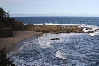
It was low tide at the Cape Arago environs, the retreating ocean exposing reefs and rocky shoals to the airy elements. The booming waves at nearby Shore Acres are famed the world over but on this morning, they were barely making a ripple. The wind-driven whitecaps out to sea were larger than the waves lapping against the shore like a thirsty cat at a water dish. However, the ocean patiently bides its time and will once again rampage against the coastal ramparts come high tide.

Panorama of Simpson Reef 

From the gardens and viewpoints at Shore Acres, the coastal trail dipped in and out of the forest, sideswiping iconic landmarks such as Simpson Beach, before winding up at Simpson Reef Overlook. At the viewpoint, tourists and hikers alike can observe the sea lion bacchanalia and debauchery taking place on Shell Island. Replete with fishy smell, all that barking, belching, and farting was kind of like a gathering of through-hikers, but without the backpacks or hiking poles.

The forested path heading up to the Pack Trail

I'm not bragging (oh, but I am!) but I've lost weight lately and where I really notice the difference is when I'm hiking uphill. There is no direct trail from Simpson Reef Overlook to Cape Arago and one can either walk along the road to the cape, or cross the road and take the forested path leading to the Pack Trail. That particular path is a steep one but my lighter new and improved self just charged uphill, nearly as quick as a brand new Soul when the light turns green. Whew, did that ever feel good!

Lunchtime view

The coastal woods, fed by the perpetual fog at the cape, were predictably lush and verdant. The earthen track wound through the trees while numerous clumps of green ferns flanked the footpath. After reaching the Pack Trail, which is actually a gravel road, it was a short drop to Cape Arago herself, where we ate lunch while admiring the view of the sparkling sea and the rugged Oregon coast running to the south.

The sea was a bit more agitated on the way back

On the hike back to the trailhead, high tide was beginning to roll in and the waves were now a lot more entertaining than they had been earlier. We (John, Merle, and I) would see a huge wave break in spectacular explosive fashion, so cameras would be readied and then we'd wait...and wait...and wait for the next large wave. It apparently is a Cape Arago truism that waves are only spectacular when you aren't pointing a camera at them.

Pictorial definition of whitewater

The cool part about going home after the hike is I got to drive my new car all over again. Unfortunately, John and Merle took the occasion to pepper me with technical questions that I did not know the answers to, other than "Yeah, I'm pretty sure it has a motor". My ignorance of all things automotive was further exposed at my first fuel purchase when the attendant asked me to pop the gas tank lid open. Crap, how do I do that? Shaking his head in condescension and with a smirk on his face, the dude showed me where the lever was down on the floor by the seat. Hiking is so much easier!

A wall of solid rock, exposed by the low tide

For more photos of this hike,
please visit the Flickr album.

Saturday, November 19, 2016

Cape Arago Perimeter Trail - club hike

The weekend prior was a mere scouting expedition and this weekend was the real deal. Armed with knowledge gleaned from my information-gathering foray 8 days earlier, I was confidently ready to lead the Friends of the Umpqua onto Cape Arago Perimeter Trail. Just call me a modern day Jedediah Smith! Except Jedediah didn't drive to the trailhead, there was no established trail to follow, and he didn't feel compelled to take pictures of every wave that crashed upon the rugged Oregon shore. But other than that, yeah, I'm a modern day Jedediah Smith alright.

Perimeter newbies (except for Rachel)
Weatherwise, we were between storms so we hiked in dry but blustery weather with a gray cloud cover overhead. Spirits were high as we set out on the forest trail to Shore Acres State Park where we picked up the hard to find Perimeter Trail. From here on in, it would be all new trail for my fellow hikers who (except for Rachel) had never been here before.

Ariel enjoys a downhill section of trail


Because I had taken lots of photos the week before, had written a blog entry about the hike, not to mention a newspaper story about the same hiking experience, I had pretty much decided to take little or no photos and simply concentrate on making sure I didn't lose any hikers along the way. So blah, blah, blah, and I'll refer you to my previous blog posts for more details about about the joys and travails of hiking on the Perimeter Trail.

Jedediah Smith (not!)
After lunch, we dropped down to Cape Arago where we paid a visit to the cape overlook, a coastal delight I had bypassed last weekend. The wind buffeted and cuffed us as we walked on the exposed cape, and if I had any hair, it would have been messed up.


Ooh...aah
From there, the short road walk on the Cape Arago Highway delivered us to the Simpson Reef Overlook, where we took in the sights, sounds, and rank odors of the sea lions hanging out on Shell Island. And then it was back to the trail.

Photogenic surf at Shore Acres
I'd say it was the same old stuff but the coast is always different, that's one of the reasons I enjoy hiking at Cape Arago on a regular basis. Before you could say "spectacular Oregon coast", the camera was out and clicking and I soon found myself well behind everybody else, like usual.


Life on the edge
The clouds were breaking up in the late afternoon and the sun valiantly tried to shine its sunny magic on us Vitamin D deficient seasonal affective disorder sufferers (which has the appropriate acronym of SAD). However, a massive bank of clouds several miles offshore quickly rolled in, blotting out the sun and making us very SAD. But the war between sun and clouds resulted in a bad case of great lighting affective disorder (or GLAD) and much photography ensued from a very slow but GLAD hiking leader.

A storm is coming!
So that was our hike, in a nutshell, I've short-cutted a more engaging description as it was the same old spectacular stuff I wrote about just a week earlier. I bet Jedediah Smith would have done the same.


View to Gregory Point
For more pictures of this hike, please visit the Flickr album.

Friday, November 11, 2016

Cape Arago Perimeter Trail

On occasion I lead hikes for the Friends of the Umpqua Hiking Club. And since the club hikes Cape Arago coastal trail on a weekly basis (or so it seems), I thought I'd change it up a bit by taking the club on a new (for the club) hiking experience. A year or so ago, I'd been exposed to the Perimeter Trail, thanks to my South Coast Strider friends who showed me the route. However, there are several trail intersections on the loop and as I sat on the living room sofa ruminating on the twists and turns of the trail, several questions came to mind: "Was that a left or a right turn on the Pack Trail?" "Left or right on the gravel road?" Clearly, if I wanted to complete the hike with the same amount of hikers I started with, I needed to better familiarize myself with the route. And that is why a week before the scheduled hike, I found myself on the Perimeter Trail with Luna, who came along for some leash training.

The old entrance to Shore Acres Estate
After a short walk through a misty forest on the "short cut" trail to Shore Acres State Park, I followed the park roadway to the Cape Arago Highway. The trail begins on the inland side of the highway and would be impossible to find if one did not know already where the trail was. There is no sign and no obvious trailhead, although someone did tie a pink ribbon to a tree to mark the spot. For some reason, the pink ribbon reminded me of hiking buddy Lane, who may no longer be a buddy after he reads this sentence.

The Perimeter Trail heads uphill
Anyway, after parting the brush and getting on the trail proper, it was a brisk uphill climb along a creek that was totally hidden by the thick jungle that grows in the coastal woods. Ferns and coastal huckleberries were everywhere, the wet fronds making sure my pant legs got wet too. Fallen trees and forest duff were decaying everywhere, thanks to the wet clime.

Eat this and feel curiouser and curiouser!


And thanks to all that decaying biomass, mushrooms of every size, shape, and color were sprouting profusely along the trail, my hiking pace slowing in indirect proportion to numerous mycological delights entertaining the camera. White-dotted red fly agaric was a common sight and I wondered why a toxic and psychoactive mushroom has to look as enticing as an Easter egg or large candy.  Talk about false advertising!

Lichen "flowers"
After a mile or so of brisk climbing, the trail leveled out in an oddly sparse forest comprised mostly of waist high coastal huckleberry bushes and dead trees. Some of the snags showed fire scars, leading me to surmise that a fire had swept through here many years ago. Because of the open terrain, sun-loving reindeer lichen grew in thick patches upon the ground. Also, because of the lack of tree cover, rain pitter-pattered on my hat brim, I hadn't really noticed the rain while hiking underneath the thick forest cover.

A small galaxy of mushrooms
The trail seemingly zig-zagged for no reason but what it was actually doing was following the stair-step boundaries of Cape Arago and Shore Acres State Parks. In particular, what it meant for me was that I had to leave that wonderful level trail and descend down to a creek drainage. What's wrong with that? Well, after reaching the creek drainage, the path then climbed out of the creek drainage. And what's wrong with that? Well, after climbing away from the creek, the trail crested a forested ridge carpeted with emerald green moss, dropping steeply down to another creek crossing. And what's wrong with that? Yup, had to hike uphill away from the creek. Up and down, up and down, that's what happens when the trail follows an squiggly arbitrary line on a map.

Leafless alder trees along a creek
There used to be an old road leading from timber magnate Louis Simpson's Shore Acres estate to Arago Peak. Nowadays, the old road bed does duty as the Arago Pack Trail and the first of three turns (left, for those keeping notes)  was made onto the Pack Trail. The trail was wide and fairly flat as it followed a forested ridge. Moss carpeted the forest floor and you could almost see forest gnomes scampering between the trees. Luna probably wanted to scamper too, but she was hampered by being tethered to her forest gnome of an owner.

Trail through the greenery
After a half-mile or so, the route intersected with the Arago Peak Trail. Not wanting to add 2 or more miles to the hike, I turned away (right) from the peak and toward Cape Arago itself. The trail dropped in a hurry and best of all, the what-goes-down-must-come-up rule did not apply in this case. Luna and I stopped for lunch at the group picnic area and she ate her lunch quickly, followed by most of mine. After a brief rest, made briefer by the arrival of a light rain, we continued down (left turn!) a gravel road to the paved Cape Arago day use area, replete with bathrooms, parking lots, and picnic tables. All the good progress Luna had made with walking without yanking the leash flew away on the ocean breeze due to all those people and dogs in the day use area. So many noses to bump and so many butts to sniff. Dog noses and butts, just to clarify. Luna was the only one of our party doing any sniffing, too, to further clarify.

Not your basic wilderness hike
Well, now that we arrived at the cape, this was all familiar territory to me. A short road walk delivered us to the Simpson Reef overlook where all the barking seals reminded me of our recent election, for some reason. Maybe it was the unintelligible cacophony, or maybe it was the foul stench wafting on the breeze, I'm not really sure. From a hiking standpoint, the reef overlook marked the resumption of actual trail as a dirt path ducked into the coastal forest above the dramatic cliffs that make Cape Arago so special.

The sea at war with itself
It seems like every time I visit Cape Arago, there is a little less of Oregon to hike on, making our new motto "Come and visit Oregon, before it disappears entirely!"  The pace of erosion seems to have accelerated over the last 5 years or so, I suspect rising sea level and climate change to be the culprit. North of Shore Acres, a substantial portion of the trail system has had to be rerouted inland and before long, they are going to have to reroute the trails south of the park as well. 

Shore Acres coast on a gloomy day
But the land meeting the sea provides for some scenic drama as wave after wave dashed against the cliffs and rocky shoals. The tide was fairly low so the waves weren't as thundering as they can be, but the camera was clicking away anyway. The sky was dramatic with swirling clouds competing with sun for control of the sky. The clouds eventually won out. 

Golden glow


The loop route was then closed by several miles of scenic coastline hiking as the day darkened. Cape Arago is always a fun place to hike and that held true for this day as well. And now that I am in total command of all the trail lefts and rights, the day was a total and unqualified success. Plus, Luna was so tired she slept all the way home. Not having your ears licked as you drive also qualifies as an unqualified success. 

Clouds painted the sky
For more pictures of this hike, please visit the Flickr album.

Saturday, February 13, 2016

Bastendorff Bog Trail

I've hiked in the Cape Arago area for what seems like a million times. Despite being overly familiar, the cape is one of my favorite places and is always spectacular; be it at night, in the fog, in a torrential downpour, or on a sunny day. Unfortunately, the relatively small state parks in the area don't offer much options for hiking other than the spectacular trail along the coast. However, thanks to the South Coast Striders, a Coos Bay hiking group, I've had my horizons broadened as they've exposed me to the Perimeter Trail and now, the Bastendorff Bog Trail.

The forest needs no "sprucing" up!


The Bastendorff Bog Trail is a mile'ish long path that runs from Sunset Bay Campground to Cape Arago Highway near Yoakam Point. I've driven by the trail many times but unless you know where it is, you'd never know it was there; it's like the ninja night assassin of trails. Although the Bastendorff Bog Trail officially ends at the highway, a loose network of use-trails on the other side takes hikers to various viewpoints and beaches on and below Yoakam Point and is the answer to the age-old question "why did the hiker cross the road?"


Skunk cabbage
Approximately 30 hikers took the green flag and began ambling through Sunset Bay Campground, exchanging morning greetings with campers rubbing the smoke and sleep out of their eyes around their respective campfires. The trail officially began in the hiker and biker camp which somehow seemed appropriate enough. On a slippery footbridge, we crossed Big Creek's muddy bog replete with blooming odiferous skunk cabbage, and then began a short but brisk charge uphill through lush coastal forest.

On the Bastendorff Bog Trail
After a half mile or so on a trail flanked with dense salal and coastal huckleberry bushes waving green fronds over the trail, a loosely defined Bastendorff Bog made an appearance on the right side of the trail. Apparently, the bog is home to a population of rare and endangered western bog lily; the showy blooms would make spring a good time for a return visit. However, in February, there was not a lot going on in the bog.

A big lump of coal for Christmas
Past the bog, the trail spit us out onto Cape Arago Highway from the aforementioned hidden trailhead after a mile or so. But no worries, the hike hadn't ended yet. Across the busy highway was that collection of rough paths that wander the forested bench of Yoakam Point. Mild bushwhacking yielded intermittent open areas in the forest with the open areas providing views of the rugged Oregon coast and Cape Arago Lighthouse perched atop Gregory Point (actually an island). Below the point, an exposed seam of coal flashed back to the time when Coos Bay actually had a coal industry,

View from Yoakam Point
The actual point of  Yoakam Point is narrow and exposed and there was not room enough for 30 plus hikers on it, although we did try. In the end, we took turns and cameras were kept busy on the point. The view north was stunning as mile-long Bastendorff Beach curved gracefully before dead-ending at Coos Bay's south jetty. Directly below, waves crashed upon exposed rocky reefs and crags. Way cool.


Whee!
And then the fun started! The route led from the top of Yoakam Point down to a sheltered cove immediately below by means of a rope descent on a treacherously muddy track that even mountain goats would find too dangerous. Some of us more sure-footed hikers aided the less nimble on the way down and I'm glad to report I saw only one hiker rolling down the trail with the sole injury being that of a sprained dignity. The patient is expected to recover. It is also worthy to note that the hike organizers gave no hint of this descent until the very moment it was time to descend, thereby neatly avoiding a pre-descent mutiny.


Temporary respite after the descent
So, 30 plus hikers were milling around on the secluded and sandy cove, grateful to be done with the muddy drop, when we were informed that we now had to scramble up and over a rocky point to get to Bastendorff Beach. It was then that the phrase "kill the hike leader" was first muttered. Options were limited if one did not want to risk that scramble because the only way back was by means of a rope ascent up a treacherous muddy track that even mountain goats would find dangerous. For me, this was like being on a Richard Hike but with none of the criminal liability.


And it's not even a Richard Hike!
The scramble up and over the point was not particularly tall, but the rocks were covered with slimy green seaweed that had us yearning for a treacherously muddy track instead. But again, with help from the sure-footed, all hikers made it safely over with no injuries to dignity or any body parts. And now, it was a simple mile-plus beach walk along Bastendorff Beach until we reached the south jetty.


Incoming!
While some ate lunch, others scrambled (your merry blogster included) atop the jetty boulders to observe waves marching up Coos Bay's (the bay) entrance, seemingly intent to administer a watery smiting to Coos Bay (the city). The waves were rather robust and after a few close calls atop the jetty we promptly departed lest we receive a watery smiting ourselves.


Rocky shoal near Yoakam Point
Our egress off of Bastendorff Beach was on a rather civilized trail with a footbridge or two. The tameness of the trail raised the question of why we had to make that wild descent in the first place but on the other hand, there simply is no glory in a tame trail. So, in the end,  this 6 miler was a tasty hiking smorgasbord of coastal delights. It was nice to get a new trail experience out of the familiar paths of Cape Arago.

Standing room only on Yoakam Point
For more pictures of this hike, please visit the Flickr album.