Showing posts with label cape mountain. Show all posts

Saturday, December 16, 2017

Cape Mountain 12/2017

Normally, it's a simple idea: Hop in the car and drive to the trailhead. However, the drive to Cape Mountain was more like a bus route than a simple put-it-in-gear-and-go. Not too many of my hiking buddies had ever been to Cape Mountain and I had only been once, so this hike was penciled nto the Friends of the Umpqua hike schedule with your merry blogster designated to lead the way. Well, my friends from South Coast Striders wanted to join us so we arranged a pick-up stop in Reedsport; and Lane was coming over from Springfield, so another stop in Florence was arranged. Who knew leading a hike could be so complicated? However, we managed to get all 13 hikers from all their disparate towns and walks of life to the trailhead, in spite of all the logistics. Surely, things would be simpler on the trail.

Moss and trees
Well, maybe not. First we had to hike uphill on the Princess Tasha Trail, then continue on the Scurvy Ridge Trail ("Aargh" he said, in his best scurvy buccaneer pirate voice), take a left on the Berry Creek Trail, followed by a right onto the Nelson Ridge Trail. And all that involved ignoring trail junctions with trails named Lookout, Wapati, Berry Lane, and Cape Mountain. No small wonder we started out with 13 hikers but only wound up with 10 when the hike was over. Spoiler alert: everybody eventually showed up, so all was well.

Eight miles of coastal forest
The scenery is pretty basic at Cape Mountain. Elegantly simple (like the hike leader), the "views" consist of dense growths of, ferns, salal, and moss. If you want to experience 8 miles of deep coastal forest, then this is your hike. Of course, all this simplicity came with a price, as  all of us were soon breathing heavily in short order due to a rather brisk climb to the crest of Scurvy Ridge.

Edwin squashes a hitsi-bitsy spider
A couple of miles in, we arrived at the replica hitsi (a primitive Native American shelter) that had been built as part of an Eagle Scout project. I'm not sure how long ago it had been built but the hitsi is falling into a state of disrepair as it should. since they were never intended to be permanent. Since I was the hike leader, I felt compelled to teach my charges what I know about hitsis, mainly that there is a small spider that inhabits these types of structures: it's known as the hitsi-bitsy spider. Sorry, I just can't help myself and for some reason, I hike alone a lot. 

Spooky branches


The vegetation changed somewhat on the Berry Creek Trail as we exchanged tall conifers for leafless alder trees. We also exchanged the uphill hiking for a trail that lost elevation at a dizzying rate. This was a loop trail and everybody was glad we didn't have to hike back up this path but I kept quiet, knowing we'd have to gain all that elevation again, albeit on a different trail. For stats lovers, the trail lost nearly 1,000 feet in 1.5 miles.

We now head up to Nelson Ridge
Berry Creek was waiting for us at the bottom of the canyon and we all crossed the creek on a log with no pratfalls or mishaps. And then the climbing began. In fact, most of the day was spent walking uphill even though we were hiking a loop route with no net gain or loss in elevation, . Accordingly, after a mild wade across a Berry Creek Fork, the trail charged to the top of Nelson Ridge, angling through a stand of homogeneous trees on the way,

Our lunch time view
There were a series of grassy meadows on top of the broad ridge crest, the grass currently brown and dry in preparation for winter. Fresh elk poop dotted the meadow, so we know a) elk come here to visit and b) the grass is well fertilized. There was also a bench in a meadow with a partial view down to the coast, so we plopped down after checking for elk poop, and ate lunch under a gray sky. 

Seemed like we walked uphill all day long
There used to be a forest road atop Nelson Ridge, and the former roadbed inter-braided with the actual trail and it wasn't always clear which way to go. A few more signs here would be helpful, Forest Service, if you are reading this. The road was actually the Berry Lane Trail and basically continues in the same direction as the Nelson Ridge Trail; so if anybody did take the wrong trail, they'd wind up at the trailhead anyway.

Former road, now doing duty as a trail
When we arrived at the trailhead we were short 3 hikers. Dave showed up about 15 minutes later but Lane and Ceresse were missing in action. Turned out they had come up the Wapati Trail but had to turn back to retrieve some clothing left behind at Berry Creek. It's not what you think either, the clothing item left behind was a sweater or similar accouterment that had been removed to adjust body temperature. It was duly noted that the leaver of clothing was not the same person who was appointed to do the retrieving. I'm not saying which was which, but will also note that Lane's GPS had more miles on it than Ceresse's.

Dense growth made sure we stayed on trail
Anyway, Lane and Ceresse did eventually show up, none the worse for the wear. We went to Florence and stopped at Burritos Los Amigos for some post-hike tongue tacos. That was the simplest thing that happened all day.

A nice view to Sutton Lake
For more pictures of this hike, please visit the Flickr album.


Saturday, October 3, 2015

Cape Mountain

On January 24, 1989 an angry man with a semi-automatic rifle came into the packing shed where I worked and commenced shooting. When it was over, one friend was dead, two were wounded, and the rest of us will carry scars for the rest of our lives. After it happened, I walked outside to clear my head. It was a glorious day, the sun was shining in a scintillating blue sky and my one overriding thought was "How did this happen on such a beautiful day?" It just didn't make sense.

It was incomprehensible then and it is incomprehensible now. October 1, 2015 was also a beautiful day when a gunman walked into a classroom at Umpqua Community College and took 9 lives and placed Roseburg in the dubiously elite roster of communities that have been scarred by little people with big guns. Never thought it would happen here in the town where I live but then I never thought it would happen at Monterey Mushrooms either. Especially on such a beautiful morning.

Two days after the UCC tragedy, I went out for some trail therapy. I just wanted to get away from the news and just sit in the quiet woods and shed a few tears along the way. Cape Mountain wound up being the destination du jour because about a year earlier, a hike to Cape Mountain had to be scratched due to high winds. Since, I'd never made it, that was just as good a reason as any to pick Cape Mountain as the place to visit.

On the Princess Tasha Trail
Unlike my first abortive attempt at Cape Mountain, October 3rd was a beautiful fall morn and thankfully, there were no strong winds. From the Dry Lake Trailhead, the Princess Tasha Trail angled uphill through a gorgeously lush forest. The trees were all covered with moss while salal and wet ferns encroached the trail. I had always assumed that Princess Tasha was a native American princess but a sign explained that Princess Tasha was actually a horse ridden by Christine Olsen. I won't make fun of Christine as the sign indicated that she had passed away in 1987 at the age of 21, so let's just say that one more assumption bites the dust and I hope Christine is still riding Princess Tasha in some celestial fern-infested forest.

Aargh!


At the top of a ridge, a right turn was taken on the Scurvy Ridge Trail and had I not been feeling so maudlin, I probably would have "arrghed" like a scurvy buccaneer.  This hike was not about the views at all, it was rapidly becoming apparent that I would be spending plenty of quality forest time on this venture. No complaints though, the soft soughing of the coastal breeze in the trees and the twittering of small birds were soothing to this troubled soul.

Hitsi in the woods


Back in the day, the area was populated by the Siuslaw native Americans who hunted elk and deer in these very same woods. They would build hunting cabins called hitsi, where they would spend the night in the woods waiting for the deer to raid them and steal their hiking poles. Or maybe the pole purloining is strictly a Richard O'Neill experience. At any rate, a hitsi replica had been built as an Eagle Scout project and made for an interesting learning experience on the trail.

Peaceful trail
At about the 1.5 mile mark, I left the Scurvy Ridge Trail for the Berry Creek Trail. The route down to the creek was actually an old roadbed gone delightfully grassy. Leafy alder trees gracefully arched over the trail, keeping this hiker shaded and cool, although the temperature was mild and the cooling was not all that necessary. There was a bench at what may have once been a viewpoint; if it was a viewpoint, the trees had long since blocked any view to be had.


Making friends wherever I go
From there, the trail dropped 1,000 feet in about two toe-jamming miles to the bottom of Berry Creek's canyon. Any joy I may have felt about walking downhill was counteracted by the knowledge that I'd surely have to hike back out of the canyon if I wanted to return to my car parked at Dry Lake.


Berry Creek


Berry Creek was just a small creek, barely running across the trail and just as anticipated, the trail began a mad charge up and out of the canyon. There are lots of trails in the area, affording the opportunity for various loops and distances. At a trail junction, I chose the right hand fork simply because it would make for a longer hike. The grade was not as rigorous as it had been heretofore, instead the path angled upwards at a relatively gentle grade to a grassy meadow atop an open ridge.

Partial view to Florence


Apparently, the Forest Service maintains the meadows on top of the ridge as an elk habitat but I saw no elk and no sign thereof. A bench with a view to Florence was a perfect opportunity for lunch and contemplation and I partook of both activities. Despite the sun, the air was misty and even though Florence was nearby, it was still hard to see for any distance. I could make out the sand dunes on the coast and the Siuslaw River being ushered by its jetties to the sea.

Sutton Lake, way below the trail
We hikers have learned to hate ridge trails. Ridgecrest trails go up and down, are always steep, and never level. This ridge trail was no exception other than there was not much downhill at all. After providing a view of Sutton Lake, the path ducked into the forest for the last climb before dropping down to the car.


Just a gorgeous day
So, in the end I don't have any words of wisdom to explain what simply cannot be explained. There was no catharsis, no epiphany, and I still felt bad. Yet somehow, getting out into peaceful woods where things make more sense did help a little bit. Time will eventually dull the sharp edges, so to speak, and the only thing I can think of to do is to continue hiking for hiking's sake and then write silly blogs about the experience. Life does go on, and this hike was one small step (for me, anyway) towards a semblance of normalcy. 


Fern frond
For more pictures of this hike, please visit the Flickr album.


Sunday, February 8, 2015

Baker Beach Dunes


It's like my grandmother always used to say "When life gives you lots of wind, make wind puppets". Well, to be honest, she probably actually never said that and besides which, I have no idea what a wind puppet is. But that's my segue and I'm sticking to it.

The (not so) aptly named Dry Lake


Originally, the plan called for a rainy day hike out at the coast, the route being a 10 mile loop within the Cape Mountain horse trail system just north of Florence. Unfortunately, the plan would wind up getting blown far and away by the wind. However, wind was not an issue at the start of the hike from the Dry Lake trailhead, although the predicted rain was coming down and Dry Lake was not very dry. As a matter of fact not much was dry at all, including your sodden blogster  It had been raining heavily all week and most of Oregon was dutifully alert, having been rightfully placed on flood watch.
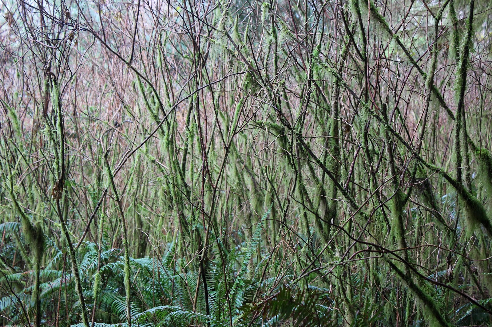


Trail omen


A short uphill walk on a mossy and ferny trail through tangled trees brought me within sight of the crest of Cape Mountain. The walk also brought me within earshot too, as through the trees the wind shrieked annoyingly shrill like an ex-wife. On the crest, tall trees kept time to the wind's music by dancing the lambada, the mashed potato, or the funky chicken. In a clear generational divide, younger trees simply twerked. Several large branches lay strewn across the trail in clear warning to a certain lone hiker with a sounds-like-a-dare mentality.


Time to play in the sandbox


Since it takes just one solitary branch to ruin a good hike, I uncharacteristically did the right thing and turned back. So what's a dressed up incredibly handsome hiker to do? Well, right across Highway 101 from the Cape Mountain turnoff was Baker Beach Road and while I might get sandblasted by the wind, at least falling trees would not be a problem. And on the plus side, prolonged exposure to wind-driven sand might be just the thing for my acne.

Um...not today
You just have to be in the mood to hike on the beach in a wind and rain storm and on this day I wasn't. So, I instead grabbed the trail that headed towards the dunes and within 100 yards it was time to make a decision at a Y-intersection. The left fork headed slightly uphill on a sandy track to Alder Lake and the right fork was under several feet of water.  Hmmm....so many tempting and difficult decisions at the start of a hike. Uncharacteristically again, I opted for the drier and tamer left fork.

Sand art


The dunes were somewhat sheltered behind the tall beach foredunes at Baker Beach, so the wind wasn't too bad and the rain also eased up a bit. I dropped off the path to Alder Lake and stepped out onto the sandy expanse of the dunes. The wind had been busy making art by fingerpainting on a large sandy canvas, leaving dunes decorated and patterned with all manner of swirls, curls, and whirls. It seemed downright sacrilegious to defile the artwork with my footprints so I generally stayed close to the forested edge of the dunes in the hiking equivalent of coloring inside the lines.

Wet spot
Because of the rain, the sand was wet and generally windproof. The lighter grains of sand were driven by the wind but mostly stayed below knee level except for when cresting a dune, at which point my poor face received the stinging brunt of the sand-laden breeze. Below my impromptu route, small lakes and large marshes discouraged cross-dune hiking to the beach. 

Please do not feed the alligators!
Life is tenuous here, and several stands of dead and half-buried trees testified to the terrible cost of war between sand and forest. But life is yin to death's yang and several patches of mushrooms surprisingly thrived in solid sand below the dead trees. The eastern edge of the dunes was bordered by a large unnamed lake surrounded by an abundance of fetid seeps containing black water, each lacking an alligator or two for a proper swamp effect. 

After the Jupiterian death ray
The sands here were different than my more usual sandy haunts (like Dellenback Dunes) in that the lighter and blacker grains of sand pooled around the many dimples on the dune surface, giving the dunes an odd singed look as if the terrain had been blasted by a Jupiterian death ray. If so, then the deer still survived.

The Three Sisters (of the dunes)
After a couple of miles, the southern terminus of the dunes was reached and there was no more walking south. The dunes here ended rather abruptly, overlooking a tangled mess of alder and conifer trees. A nice view of the forested depression of the Sutton Creek drainage was had from the sandy rim. Despite all the trees below me, I just knew there was nothing but standing water underneath the forest canopy, and I base that surmise on past hiking experiences in the Sutton Creek area.

Mushrooms in sand
After eating lunch while rain pitter-pattered on my hat brim, I explored several small fingers of sand dunes before finally running out of sand to walk on. Coming out of the forest onto the dunes was a well-used sandy path that was the trail connecting Sutton Creek to Baker Beach. Remember the right fork submerged under several feet of water?  I did, so I stayed in the dunes, saving the path for a substantially more dry-footed hike in summer.

Oasis in the desert
Bisecting the Baker Beach dunes was a large marsh and on the return leg I went left around the marsh instead of right. Well, right was right and left was wrong in this case as I found myself wading through thicker and thicker brush, my only reward being a wade through deep water if I so chose. So a backtrack was enacted and the correct route around the marsh was taken. 

As the weather turned bad
The weather became decidedly belligerent about 15 minutes away from the trailhead. It was near tornadic conditions as the wind picked up in intensity, the raindrops became fatter and wetter, lightning flashed overhead, and loud booms of thunder spurred a certain lone hiker to hike back to the car spastically fast like a wind puppet.

Test pattern
For more pictures of this hike, please visit the Flickr album.