Showing posts with label soda mountain wilderness. Show all posts

Friday, May 14, 2021

PCT (West from Soda Mountain TH to livestock pond)


Some niggling little health problems (I'm fine, thanks for asking!) predestined this overnight backpack trip in the Cascade-Siskiyou National Monument to be a short one. However, despite the diminutive mileage, this hike was big in forests, scenery, and hugely epic (but not in a good way) when it came to weather conditions. Still, two out of three is a passing grade and I could have always stayed home to file my crusty old toenails. 

Look, a hiker, let's get him!

When I hoisted my backpack onto my shoulders at the trailhead, the sky was blue, the temps were mild, and all was bathed in bright sunlight despite a looming bank of baby thunderhead clouds parked several safe miles to the east. Perfect conditions for hiking in and you'd never suspect bad weather could become an issue on this hike, but such is Oregon weather and keep on reading, dear readers of mine.

Not all the snow had yet melted off

May is, in my humble opinion, the optimal time to visit the Cascade-Siskiyou National Monument. The small mountain range of the Monument bridges the gap between the Siskiyous and Cascades mountain ranges and the whole vibe is at turns, either or neither or both Cascade and Siskiyou in terms of vegetation, climate, and geology. In about a month or so, the terrain will brown out due to the aridity of the area, the dried out hellebore meadows then rattling in the summer breeze like thousands of cackling witches. But in May, the snows have not completely melted, the forests are damp, the mountains are cloaked in a green blanket of lush vegetation, and wildflowers put on a show for camera-toting backpackers.

After the storm

The Pacific Crest Trail bisects the Soda Mountain Wilderness, a wilderness preserve set within the Monument's boundary. In the Wilderness, the forest was cool, dark, and shady while a virtual army of marching trilliums bloomed on the forest floor, if thousands of elegant flowers could be accurately described as a marching army. Maybe that's not an apt descriptor but it would not be the first time I babbled or dabbled in inept metaphors. At any rate, there were lots of white trilliums blooming, with bluish Oregon anemone and nodding glacier lilies playing a significant supporting role.

Avalanche lilies were everywhere

Periodically, the trail would break out of the forest and onto open slopes that tended to be somewhat on the rocky side. On either side of the trail sprawled huge meadows with nubs of sprouting hellebore being just a few inches tall. A byproduct of the open meadows or rocky slopes were expansive views of Bear Creek Valley with Mount Ashland dominating the skyline and crest of the Siskiyou Mountains. Snow had been here until just recently, evidenced by the sprouting hellebore and rampant patches of avalanche lilies, the dangling star-shaped flowers pointing face-down toward the ground, which was still wet and muddy thanks to the recently thawed snow.

The water pond and yes, I drank the water


In one of the meadows, there is a small livestock pond that is an important water source for PCT hikers as water gets to be in very short supply in August, when the through-hikers pass through Oregon on their way to Canada. Camping near the pond was a little problematic because the soil was wet and mushy during my initial search for a camping spot. However, a long and broad meadow extended north and I set up camp on the meadow's edge, with an awesome view of the valleys and mountains dropping and rising from my campsite as my reward.

Larkspur inhabited the meadows, too

The low grasses were chock full of short flowers, notably those of larkspur and the ever plentiful avalanche lily. When not crawling on my hands and knees in my never-ending quest for the perfect wildflower photo, I spent time at the edge of the meadow, admiring the view as the day waned into late afternoon. But clouds rolled in overhead and the day went dark while a gusty breeze began to shake trees and tent alike. Yet, looking north and west, Medford, Ashland, and Mount Ashland were enjoying a sunny day while I was having to unfairly contend with ever increasingly belligerent weather.

Rain cometh, it has been foretold

The weather continued to turn and the light clouds turned as dark and oppressive as a pessimist in a bad mood. The breeze increased in velocity and I was having to restake my tent every now and then as bellicose air currents worked the stakes loose from the very soft soils of the meadow. Soon a nonstop pitter-patter of raindrops on my hat brim announced the change from intermittent shower to out-and-out rain. Yet, the sky to the north was tinting yellow and orange as sunset drew nigh while I was stuck on my meadow having to endure the elements.

Strange weather over Emigrant Lake

Tired of getting wet, I retired early, listening to the soothing sound of rain on my tent. Not so soothing however, was the rumble of distant thunder. In short order, I could see flashes of lightning and discerned the lightning was fairly far away, for I could count up to five before the thunder arrived. Pretty soon though, I couldn't even count up to one and if I closed my eyes, I could see the veins in my eyelids every time the lightning flashed. And that thunder was loud too, each boom starting in the left ear and finishing in the right like an Airbus A380 from Hell dive-bombing my puny tent from east to west.

Sunset at the same time as the hail
storm was pummeling my tent

The staccato noise of the rain on my tent fly suddenly changed in tenor and intensity. Those raindrops were now fat and heavy and I stuck my head outside of my tent to see the latest weather wonder. What fresh new Hell was this? Instead of rain, my tent was being pelted by heaviest hailstorm ever. I almost said "Well, at least it's not large-sized hail!" but managed to catch myself before that thought was uttered out loud. Because the wind insisted on working my tent stakes loose, the tent's roofline sagged a bit and the hail began collecting in the dip. Removing hail off of the tent was added to my list of weather-related duties. Yet, while hail accumulated on and around the tent, light from a beautiful sunset over Mount Ashland was slanting into my eyes. Weird.

The next day was like "Rainstorm? Lightning? Hail? Really?"

The hail lasted about an hour and a half and the whole storm about five hours in duration. But eventually and for no reason at all, all went quiet as if the Supreme Storm Master had capriciously flipped the "OFF" switch just because she could. The peace and quiet were most welcome and I then fell into a relaxing slumber that was probably more exhausted stupor than sleep. The next day dawned bright and near cloudless, making for a nice and easy hike out while at the same time, reminding me I had definitely picked the wrong evening for my first backpack trip this year. 

Right outside my tent door

For more photos of this hike, please visit the Flickr album.

Friday, May 18, 2018

Boccard Point

Just had to go get me some Cascade-Siskiyou National Monument! I love this place and really, spring is the time to go as the dry summer climate can brown out hills and meadows fairly early in the year. Ah, but in spring, meadows are green and lush, the shady forest is burgeoning with spring growth, and erstwhile arid barrens sport colorful rock gardens. Regrettably, this beautiful jewel in the National Monument system is currently on the chopping block, thanks to a misguided president who does not hike. It really would be a shame to ruin this wilderness with logging, grazing, and motorcycles.

Dangling gooseberry


Brad is slated to lead a Friends of the Umpqua hike here in June and he didn't know Boccard Point from a bagel. Naturally, that would bring into question his leadership abilities: knowing where you are going does tend to automatically impart an air of confidence and competence. Richard to the rescue, though! I was enlisted to show him the way ahead of the official hike, and I only too gladly obliged, seeing how this wilderness is one of my favorite hiking haunts.

Dwarf hesperochiron ruled dry soils
We couldn't have picked a better day. It had rained the evening before but we began hiking under a gloriously blue sky. Despite the ample sun, the temperatures were fairly mild and the forest had that whole post-rain moistness thing going on. Leaving the Hobart Bluff Trailhead, the Pacific Crest Trail (PCT) ambled under some power lines right at the start and entered an arid field. Despite the dryness in the open and rocky soil, phlox, larkspur, and thousands of dwarf hesperochirons were coloring up the rocky barren. We hadn't walked even a quarter-mile and already, I was crawling on my hands and knees, photographically cataloging every wildflower specie thriving in the small barren. Welcome to "Hiking with Richard", Brad!

Trillium dominated the shady forest


One of the things I particularly enjoy about this stretch of the PCT is that the scenery alternates stark hardscrabble with verdant forests and meadows. It's like a patchwork quilt of contrary macro-ecologies. So, after the hands-and-knees photo-shoot of low-growing wildflowers, we followed the PCT into a wonderfully shaded forest with elegant and stately trillium blooming in profuse rampantness (Rampitude? Rampantenacity? Rampantage?). 

Meadow...'nuff said!
Once past the intersection with the Soda Mountain Trail, the PCT leapfrogged from meadow to meadow, all colored bright green under an equally bright blue sky. There is just something about blue and green that is inherently pleasing to the eye. We were hiking on the Cascade-Siskiyou crest and and enjoyed constant and great views down Bear Creek Valley, Ashland, Medford, and the Siskiyou Mountains near Mount Ashland. 

The venerable Pacific Crest Trail
The trail had been remarkably level for the first several miles but then it plunged for a mile or so, losing elevation at an alarming rate, considering we would have to gain it all back on the return leg. The mile-long descent ended at a jeep-road/trailhead combo and that was our cue to leave the PCT and follow the faint path to Boccard Point.

Sketchy path near Boccard Point
Before losing all that elevation, we had a pretty close sideswipe view of Boccard Point but the PCT had continued on past the point for the aforementioned mile of downhill walking. Now, the Boccard Point Trail doubled back below the PCT and gained all the lost elevation and distance back, with the same deleterious effects on the way out. Trail designers are sadistic demons, there is no other way to explain the route.

Trail, barely visible atop Boccard Point
While faint and sketchy, the path followed an old roadbed so the route was easy to follow as it angled gently and steadily for the two miles leading up to Boccard Point. The day had warmed up considerably from our cool start, and we were feeling the sun on the open roadbed. Finally, the trail leveled out in shady forest atop Boccard Point and we ate lunch on a small promontory.

You can see California from here!
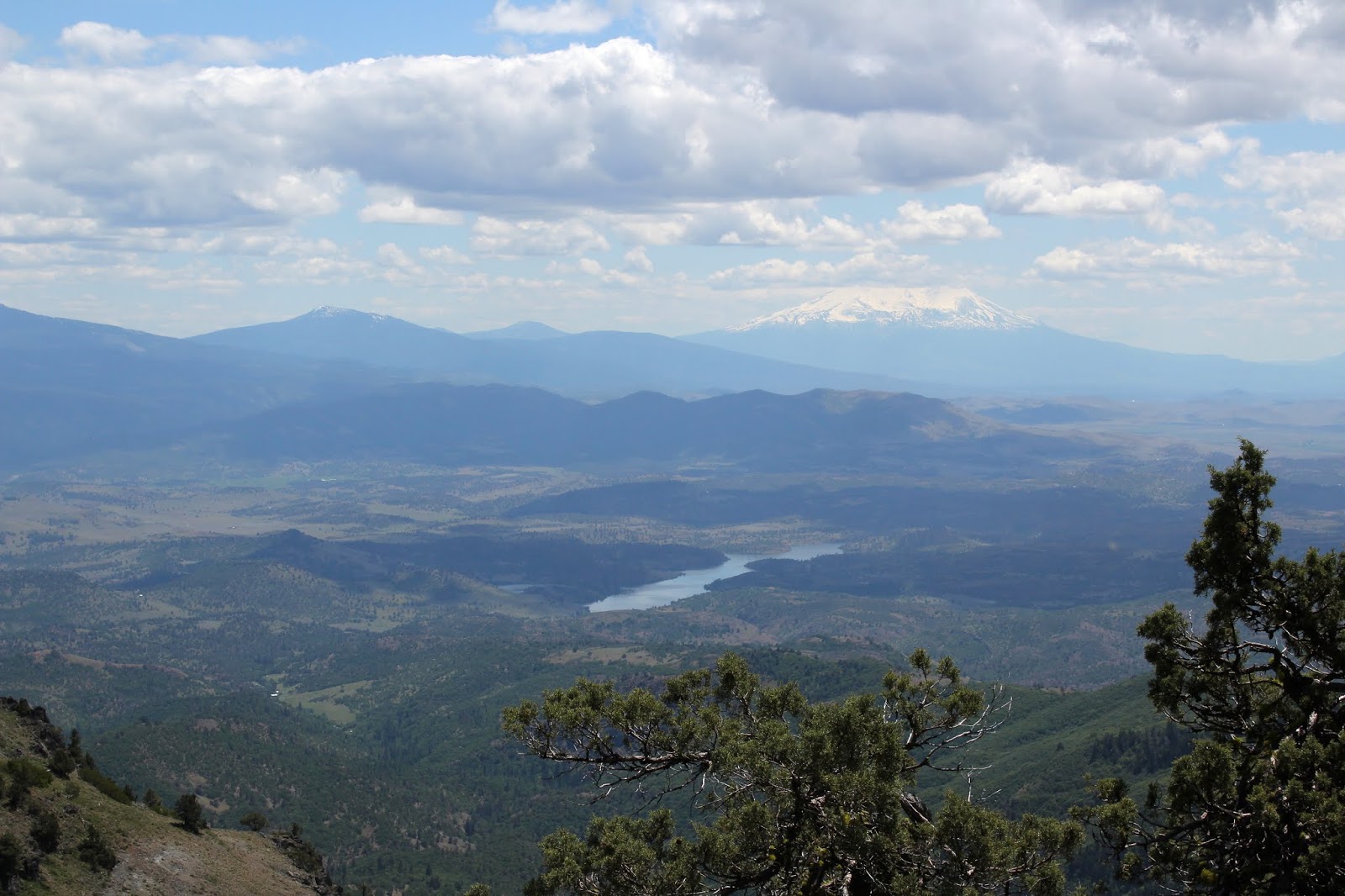
Lunch always tastes better when spiced up with a view, and this lunch was delicious. To the west, Pilot Rock was the nearest neighboring peak, it's silhouette backdropped by the slightly snow-covered Siskiyou Mountains. But it was the view to the south commanding our rapt attention. The Cascade-Siskiyou mountain range dropped at our feet and Irongate Reservoir glistened in the afternoon sunlight. Mount Shasta, its snowy tip hidden by clouds, rose up on the opposite of the Shasta Valley.  Bowing down at Mount Shasta's feet like a devoted disciple, Black Butte displayed the reverence that is only proper when in the presence of greatness. To the west of Shasta was Mount Eddy and the rest of his Scott Mountain friends. It was amazing to consider the very same PCT we had hiked on today, also traverses Mount Eddy in the far distance

Brad-fu
The view was epic and eminently enjoyable and besides which, us Oregonians derive a certain smug satisfaction from looking down our noses on California, both literally and metaphorically. The magnificent scenery just compelled us to act like the idiots we are, so I broke out my "Running Man" pose while Brad busted some sword-fu fighter move which he called "The Brad".

The tip of Mount McLaughlin, from the PCT


All that re-gaining of lost elevation was not fun and I was pooped by the time the PCT crested a mile or so west of Soda Mountain. But fortunately, the trail was level from there on in. The act of taking a photograph is the last refuge of a tired hiker, and more pictures were amassed as this 10 mile hike came to a close. Despite the fatigue, I still remain madly, deeply, and truly in love with the Cascade-Siskiyou National Monument.

Hazy view down Bear Creek Valley
For more pictures of this hike, please visit the Flickr album.


Saturday, August 13, 2016

Pilot Rock


H, O, and T. Three little letters, harmless by themselves but when joined together in a certain order they can bake hiker brains to a runny casserole and turn athletic leg muscles into Spam pudding. Yup it's been hot lately, routinely exceeding 100 degrees on a daily basis. Given all that, who's up for a Richard Hike? Well, only three people answered the call, the rest of the hiking club stayed at home and three cheers for Bill, Lane, and newcomer Wendy.


Pilot Rock
So yeah, it was hot in Roseburg and Medford but up in the Cascade Siskiyou National Monument it was about 15 degrees cooler, so a chilly "nyah, nyah!" to all you air condition-o-philes! We would be spending virtually all day on the Pacific Crest Trail and the trail was quite busy with thru-hikers doing their 20+ miles per day on the way to Canada.


The meadows are browning out this time of year


From past experience, my recollection of the trail was of open slopes all covered with snow. Of course, it had been the middle of winter and Ray and I had snowshoes on. Naturally, the snow was long gone but the open areas remained and were now meadows, starting to go brown with the end of summer looming near. What I didn't recall was just how much shade time there is on the trail and a good thing too, it helped keep the burner on low, so to speak.


View to Mount Ashland
For the first several miles, the trail alternated between oak savannah, scratchy brush, pumice barrens, and open meadows. This hike had more variety than a jar full of jelly beans. Of course, we felt the sun's brunt when out in the open but shade was always around the corner so it really wasn't bad at all. From the breaks in tree cover, we enjoyed intermittent views to Mount Ashland and her other Siskiyou Mountains friends.


What California looks like


At a saddle with a five-way road junction, Pilot Rock made its first appearance with still a mile or two of hiking yet to go. We crossed all five roads and continued on where the PCT wrapped around the west side of Peak 5241. While sidehilling the slopes of the small peak, we Oregonians enjoyed looking down our noses at California below. The citizens of Hornbrook were going about their business, totally unaware of our self-perceived smug air of superiority. 

And speaking of greasy, toxic substances...
Rounding peak 5241, the trail entered the most sustained barren encountered on this hike, comprised of low grass struggling to survive in the pumice-based soil. We could look up the Emigrant Creek drainage and pick out Soda Mountain, Hobart Mountain, and Hobart Bluff on the Cascade-Siskiyou skyline. Unfortunately, at this point some nasty grease or other toxic substance absolutely covered my camera lens and all the photos I had taken at that point were useless. But take my word for it, it was pretty spectacular.

Scotch thistle
Anway, after switching filters (now I had a funky ND filter which I don't like but at least it wasn't slimy with what ever slimed the first filter) we continued on with the trail dropping through firs providing some very welcome and effective shade. After a short downhill stint, we ate lunch at a saddle below Pilot Rock as PCT thru-hikers passed by. 

Convention has it that PCT thru-hikers are known only by their trail names, given to them by fellow hikers based on some kind of incident or story. One fellow was given the name He-man by his brother because he "hiked so easily over hills that it looked like he was made out of helium." On the Periodic Table of Elements, the abbreviation for helium is He, therefore: He-man. Based on that story, my trail name would be Pb-Man because Pb is the scientific abbreviation for lead.

Rough trail to Pilot Rock
La-Man on the PCT
It used to be that from the saddle, hikers would just go cross country to Pilot Rock. Accordingly, a whole network of ad hoc use trails sprung up, scarring the terrain. Now that the iconic tower of rock is Monument property, the old scramble route is off limits due to the ongoing vegetative restoration project. An actual authorized trail switchbacks from the saddle and it's a steep one through a forest. Pilot Rock became less of a tower and more of a wall the closer we got to it. The path ended where the scramble route to the summit started; the scramble route was not obvious but was a narrow chute that clearly required the use of hands.

Pilot rock looms above
A lone hiker was descending and he told us rocks as big as his head had fallen and he aborted the mission at that point. So did we. Lane and Bill went up for a bit with Lane working his way to a cliffy viewpoint while Wendy and I just watched. No matter the summit was not attained, Pilot Rock is still pretty spectacular and provides an up close look at all the basaltic pillars it is comprised of. At the base were piles of rocks, some even as big as my head, and that's pretty big!

The bravest souls in Roseburg
After our up-close commune with Pilot Rock, we headed back down the trail, about 5 miles from my car. If anything, the day had gotten warmer but again, we were saved by intermittent shade and breeze as we continually exchanged greetings with a steady stream of thru-hikers walking in the opposite direction. It was about 90 degrees at the trailhead and over 100 degrees down in Medford. Despite the heat in the valleys, hiking sure beat staying at home like an air-conditioned namby-pamby.

Almost lush at McAllister Spring
For more pictures of this hike, please visit the Flickr album.


Saturday, July 16, 2016

Mount Ashland Meadows

One of our hiking buddies once commented that given the right mood and ambition, he might go on a Richard Hike. And under the same conditions he might go on a Ray Hike. But he would never, ever go on a Richard and Ray Hike! We took it as a compliment. Sadly, my Trail Brother Ray recently passed away and all I've been thinking about is the wonderful adventures we shared in such a short time. We've hiked not only in beautiful weather but have hiked, camped, and backpacked in rain, sleet, snow, ice, thunder, lightning, and gale-force winds. We hiked not only in our Umpqua National Forest but we also trekked in Washington and California, visiting many a remote wilderness area in the process. We slapped at mosquitoes and blackflies, danced away from rattlesnakes, and fought off marauding deer. We walked on beach sand, rocky trails, snow drifts, volcanic ash, and waded across many a creek or river. Sometimes we hiked where there were no trails at all.  And all the while, a steady dialogue of good natured insults were directed at each other. And of course, there was "The Ray", his signature pose where he raised his arms and hiking poles overhead, usually in triumph and glory atop a mountain summit. It seemed like every hike was epic and most certainly were memorable. 

Mount Ashland
When we did not hike with each other, we hiked where the other had not yet been. Upon returning home, the taunting began with "Guess where I went today?" emails going back and forth. It was a ritual of sorts where the tauntee would complain to the tauntor about tainting the trail for future use. Ray and I had talked about doing a weekend backpack trip on the Pacific Crest Trail from Mount Ashland Meadows to Wrangle Gap but for whatever reason, we never pulled it off. We also talked about hiking to Siskiyou Peak as a 12'ish mile out-and-back day hike. And one particular day I did do that very thing and got to taint the trail for Ray. Later on, he did the same hike and shared his pictures with me and even though I had already been, it still felt like a taunt and taint.

Trail marker on the Pacific Crest Trail
So, when the Friends of the Umpqua went hiking on the slopes of Mount Ashland, I went along not only for the magnificent hike, but also to reminisce and to mourn the loss of a good friend. The Pacific Crest Trail doesn't care about all that though, it just lays on the ground and lets people walk on it from Mexico to Canada or vise versa. The PCT thru-hikers usually hit Oregon late July and we encountered many thru-hikers who were easily distinguished by long beards, unshaven armpits, dirty clothing, and a certain air about them that lingered in the forest long after they passed by. And the men were just as bad!

Monkshood


From the paved Mount Ashland Road, the PCT headed through a beautifully shaded forest comprised of tall conifers of various ilk. At the outset, the route took us through several small meadows in a foretaste of the magnificent meadowy goodness yet to come. The meadows were buzzing with bees harvesting pollen from the flowers. The trail was fairly level with gently rolling ups and downs and I sure love a trail with no mosquitoes on it.


Sneezeweed
After a mile or so, the trail crossed a dirt road and contoured across a rather large meadow clinging to Mount Ashland itself. Hellebore (also known as corn lily) was putting on a show along with sneezeweed, orange agoseris, tiger lily, and mountain owl's clover. Mount Ashland's profile (with a white microwave dome thingy on it) was photogenically etched against a dark blue sky.


Grouse Gap, one of my favorite places
The trail did enter the dark forest again but the trend was towards more meadow and less forest to the point where it would be all meadow and no forest. Grouse Gap is the grassy bowl where the transition to meadow becomes complete. Numerous springs and creeklets ran across the trail and the vista of green  slopes and distant mountains and valleys was pretty awesome. The Siskiyou Mountains figuratively dropped away at our feet, providing nice views of the Shasta Valley with Mount Shasta lording its snow-capped peak over us lesser beings. 

Mount Ashland lupine
John, Edwin, and I said good-bye to the hiking club at Grouse Gap and performed a short bushwhack on a pumice barren back up to the PCT. The Mount Ashland lupine, a miniature lupine endemic to the area and found nowhere else, covered the slope in half-inch high mats of grayish leaves and purple flowers. We made sure not to step on the rare and endangered lupine as we hiked up but the grasshoppers apparently find the plant quite tasty and don't care about the rarity thereof.

The PCT climbs to the Siskiyous crest


From Grouse Gap, the trail charged up a rocky cliff that had snow patches under the trees. However, the slope was relatively short so the uphill agony was short-lived, plus it offered a nice view of Mount McLaughlin's tip. And always, Mount Ashland was eminently visible across Grouse Gap. The three of us thought we were hikers extraordinaire until a young lady passed us by, out for a casual 20+ mile trail run. After bidding her adieu, we old and decrepit hikers adjusted our canes and walkers and bravely continued on, at our aged snail's pace.


John and Edwin explore Peak 7079
We called it good at Peak 7079, which was just short of Siskiyou Peak but still a respectable 10+ mile hike. We scrambled up to the top which sounds impressive until you consider the summit was only about 10 feet higher than the trail. But hey, that's how old mountain climbers roll! The terrain here was sparse and treeless so from the relatively small peak, we enjoyed the ho-hum, rather usual stunning vista to Mount Shasta and the rest of California. The view to the south was new and it was Oregon too, so naturally it was more beautiful. 

The Siskiyous are calling me and I must go


Wagner Butte lay immediately to the south and we could trace our route on nearby Mount Ashland. Several other peaks on the crest of the Siskiyous loomed to the southwest, notably Siskiyou Peak, Big Red Mountain, and Observation Peak. And don't you know I want to backpack the Siskiyou Mountains crest one of these days. Music floated up from a nearby spring in form of tinkling cowbells on a herd of cattle grazing in the hellebore. 

The Ray
On the way back, the shadows lengthened in the forest and the meadows were bathed in the afternoon glow. I'd like to say that I put Ray to rest but that'll be a process that will take a lot longer than a mere 10 miles of trail. Let's just say he was sort of with me this day and wherever he is, he'll swear I tainted this particular section of the Pacific Crest Trail. Miss you, Trail Brother.

Cow parsnip
For more pictures of this hike, please visit the Flickr album.

Monday, June 20, 2016

Hobart Bluff

Recently, I went on yet another hike in the Cascade-Siskiyou National Monument. Am I overdoing it? Will I become jaded about hiking in the Monument? Will the Monument eventually fill me with ennui? Is it possible to get too much of a good thing? I think not in this case, the scenery and greenery are just too beautiful.


Why we hike
The object of my hiking affection this time was Hobart Bluff, selected in part because of an earlier hike from Greensprings Summit to Little Hyatt Lake on the Pacific Crest Trail. I remember my comrades asking me what was south of Greensprings Summit and the short answer is Hobart Bluff. The long answer is the border with Mexico. Anyway, this area dries up and goes brown fairly early so I figured I'd better go to the monument one more time while everything is still beautifully green.

This hike sponsored by Pale Ale
The weather was great as the sun was out, the sky was gloriously blue and best of all, the temperature was mild and perfect for hiking. From the trailhead, the venerable Pacific Crest Trail climbed gently in a fenced corridor on private property. Once past a couple of gates, the trail would be on public land the rest of the way and thanks to the property owners for allowing the trail to pass through their land.

Dry meadow on the PCT
The trail ambled through an odd mix of lush Cascadian conifer forest and open Siskiyou-ish meadows and oak savannas. It can also be an odd mix of mosquitoes and ticks, based on the same vegetative mix but on this day I was lucky enough to not have to deal with either pest. This area is fairly arid when compared to the moister Cascades, here the meadows were already going brown in the rockier stretches of trail. One good thing about meadows is there are no trees to block the view and periodically I caught glimpses of Pilot Rock and Mount Ashland.

Blue-headed gilia
Spring was in session, and my hiking pace was relaxed as there were so many wildflowers to take pictures of. Purple balls of ookow were the main culprit but white hyacinth, thimbleberry, columbine, Indian paintbrush, and larkspur all made their floral presence known. I was happily taking photos and just go ahead and call me a flower child.

Phantom orchid
After several miles of drying meadows alternating with oak or conifer forest, the trail climbed up a slope that was comprised mostly of old-growth Douglas fir. The trail was well shaded with lush vegetation greening up the forest floor underneath the massive trees. Phantom orchid is a fairly rare plant but here it was sprouting everywhere. Pick a square dekameter of forest floor at random and hundreds of pale white shoots would still issue out of the ground like ghostly wraiths from the underworld. The orchids were a pleasant distraction from one of the few steep stretches of trail.


A hike with a view
Shortly after leaving the orchid-infested slope behind, the trail crossed over to the east side of the ridge crest and the forest transitioned to scrubby chaparral and thin stands of scrawny oaks. The views from the open slopes transformed this hike from "pretty darn cool" to "Dude!" (in the like, totally awesome sense of the word). Miles and miles of hills and volcanic cones carpeted by forest lay underneath a blue sky. Nearby Parker Mountain was the most prominent peak as the landscape rolled towards Klamath Falls, but fortunately the town was not visible. I know that may have been an underserved Klamath Falls cheap shot, but then again, I've been there!

A bee-fly sips from a larkspur
Periodically, oaks arched over the trail and the mottled shade was most welcome and soothing. Swallowtail butterflies flitted from flower to flower and my camera was quite busy with shady trail, abundant wildflowers, insect life, and expansive views.

This way to Hobart Bluff
So far, the route had not been all that strenuous as it rambled along the ridge crest in relatively gentle ups and downs. Hobart Bluff would require some more exertion however, as the trail to the summit charged madly up the bluff, about as subtle as an enraged bull on the other side of the fence from the cow. Stunted and gnarled juniper trees dotted the grassy slopes of the bluff.

Hobart Lake, from the world's tallest diving board

Hobart Mountain (near) and Pilot Rock (far)
After attaining the actual Hobart Bluff summit, I picked my way down to a rocky point which was the definitive edge of the bluff, one more step and I'd painfully splash into Hobart Lake, about 450 feet below. The 360 degree view from Hobart Bluff was predictably spectacular, especially on such a glorious day. Hobart Mountain is Hobart Bluff's immediate neighbor, its green slopes rising in front of equally green Soda Mountain. In the distance was the squat tower of Pilot Rock, looking somewhat alien in all the forested mountains. Farther away were Mount McLaughlin, Mount Ashland, and the tip of Mount Shasta. However, Bear Creek Valley stole the Hobart Bluff show. Wide and deep, flanked by tall mountains, the valley stretched from Ashland to Medford and I was staring right down the valley's throat like a geologic tonsillologist. Way cool and lunch just tastes better when eaten in the presence of such an awesome vista.

Meadow, set aside as habitat for
the endangered Mardon skipper
All good things come to an end though, so after a lazy lunch, it was time to get off the butte and head back down the trail. I had entertained a notion of summiting Hobart Mountain's green and grassy slopes so I continued on the Pacific Crest Trail to the foot of the nearby mountain. Upon closer inspection, the green grass was actually a dense head-high thicket of brush and small trees. Wanting to keep my skin reasonably unscratched, I instead continued on to the Soda Mountain Trailhead for some extra mileage. The trailhead was the logical turnaround point, but not before availing myself of the brand new outhouse. Actually, I think if I bushwhack around (next time) the north side of Hobart Mountain, I should be able to make it to the summit.

"Get that camera out of here!"
The afternoon cooled off a bit as the sun sank low or maybe it was just my appreciation for shady forests, but it was a pleasant hike back to the car. So, in answer to my question first posed in this blog entry, one more hike in the Cascade-Siskiyou National Monument is not too much of a good thing. However, other trails in other places are also calling to me and I'll save the few remaining monument trails for a later date.

The PCT alternated between sun and shade
For more pictures of this hike, please visit the Flickr album.

Grassy stretch of trail