Just had to go get me some Cascade-Siskiyou National Monument! I love this place and really, spring is the time to go as the dry summer climate can brown out hills and meadows fairly early in the year. Ah, but in spring, meadows are green and lush, the shady forest is burgeoning with spring growth, and erstwhile arid barrens sport colorful rock gardens. Regrettably, this beautiful jewel in the National Monument system is currently on the chopping block, thanks to a misguided president who does not hike. It really would be a shame to ruin this wilderness with logging, grazing, and motorcycles.
 |
Dangling gooseberry
|
Brad is slated to lead a Friends of the Umpqua hike here in June and he didn't know Boccard Point from a bagel. Naturally, that would bring into question his leadership abilities: knowing where you are going does tend to automatically impart an air of confidence and competence. Richard to the rescue, though! I was enlisted to show him the way ahead of the official hike, and I only too gladly obliged, seeing how this wilderness is one of my favorite hiking haunts.
 |
| Dwarf hesperochiron ruled dry soils |
We couldn't have picked a better day. It had rained the evening before but we began hiking under a gloriously blue sky. Despite the ample sun, the temperatures were fairly mild and the forest had that whole post-rain moistness thing going on. Leaving the Hobart Bluff Trailhead, the Pacific Crest Trail (PCT) ambled under some power lines right at the start and entered an arid field. Despite the dryness in the open and rocky soil, phlox, larkspur, and thousands of dwarf hesperochirons were coloring up the rocky barren. We hadn't walked even a quarter-mile and already, I was crawling on my hands and knees, photographically cataloging every wildflower specie thriving in the small barren. Welcome to "Hiking with Richard", Brad!
 |
Trillium dominated the shady forest
|
One of the things I particularly enjoy about this stretch of the PCT is that the scenery alternates stark hardscrabble with verdant forests and meadows. It's like a patchwork quilt of contrary macro-ecologies. So, after the hands-and-knees photo-shoot of low-growing wildflowers, we followed the PCT into a wonderfully shaded forest with elegant and stately trillium blooming in profuse rampantness (Rampitude? Rampantenacity? Rampantage?).
 |
| Meadow...'nuff said! |
Once past the intersection with the Soda Mountain Trail, the PCT leapfrogged from meadow to meadow, all colored bright green under an equally bright blue sky. There is just something about blue and green that is inherently pleasing to the eye. We were hiking on the Cascade-Siskiyou crest and and enjoyed constant and great views down Bear Creek Valley, Ashland, Medford, and the Siskiyou Mountains near Mount Ashland.
 |
| The venerable Pacific Crest Trail |
The trail had been remarkably level for the first several miles but then it plunged for a mile or so, losing elevation at an alarming rate, considering we would have to gain it all back on the return leg. The mile-long descent ended at a jeep-road/trailhead combo and that was our cue to leave the PCT and follow the faint path to Boccard Point.
 |
| Sketchy path near Boccard Point |
Before losing all that elevation, we had a pretty close sideswipe view of Boccard Point but the PCT had continued on past the point for the aforementioned mile of downhill walking. Now, the Boccard Point Trail doubled back below the PCT and gained all the lost elevation and distance back, with the same deleterious effects on the way out. Trail designers are sadistic demons, there is no other way to explain the route.
 |
| Trail, barely visible atop Boccard Point |
While faint and sketchy, the path followed an old roadbed so the route was easy to follow as it angled gently and steadily for the two miles leading up to Boccard Point. The day had warmed up considerably from our cool start, and we were feeling the sun on the open roadbed. Finally, the trail leveled out in shady forest atop Boccard Point and we ate lunch on a small promontory.
 |
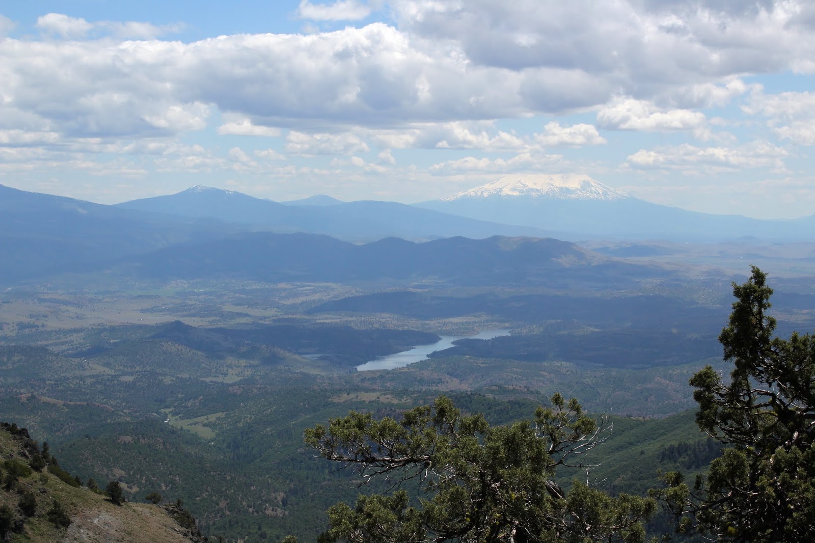
| You can see California from here! |
Lunch always tastes better when spiced up with a view, and this lunch was delicious. To the west, Pilot Rock was the nearest neighboring peak, it's silhouette backdropped by the slightly snow-covered Siskiyou Mountains. But it was the view to the south commanding our rapt attention. The Cascade-Siskiyou mountain range dropped at our feet and Irongate Reservoir glistened in the afternoon sunlight. Mount Shasta, its snowy tip hidden by clouds, rose up on the opposite of the Shasta Valley. Bowing down at Mount Shasta's feet like a devoted disciple, Black Butte displayed the reverence that is only proper when in the presence of greatness. To the west of Shasta was Mount Eddy and the rest of his Scott Mountain friends. It was amazing to consider the very same PCT we had hiked on today, also traverses Mount Eddy in the far distance
 |
| Brad-fu |
The view was epic and eminently enjoyable and besides which, us Oregonians derive a certain smug satisfaction from looking down our noses on California, both literally and metaphorically. The magnificent scenery just compelled us to act like the idiots we are, so I broke out my "Running Man" pose while Brad busted some sword-fu fighter move which he called "The Brad".
 |
The tip of Mount McLaughlin, from the PCT
|
All that re-gaining of lost elevation was not fun and I was pooped by the time the PCT crested a mile or so west of Soda Mountain. But fortunately, the trail was level from there on in. The act of taking a photograph is the last refuge of a tired hiker, and more pictures were amassed as this 10 mile hike came to a close. Despite the fatigue, I still remain madly, deeply, and truly in love with the Cascade-Siskiyou National Monument.
 |
| Hazy view down Bear Creek Valley |
For more pictures of this hike,
please visit the Flickr album.


Looking forward to joining the group on this hike!
ReplyDelete