Showing posts with label creek. Show all posts

Saturday, September 17, 2022

Fish Lake


Back in 2004, I first hiked along Fish Lake Creek to Fish Lake via the Fish Lake Trail. It had been two years after the Tiller Complex Fire(s) had swept through the area, completely immolating the forest all along the trail, leaving behind an obstacle course of blackened and fallen trees to hike over, under, and around. For me, it has always been interesting to come hike here and observe the forest gradually heal itself after the fire.

Site of the 2002 Tiller Complex Fire

I'm not sure what happened to the piles of trees laying on the trail in 2004, for there is very little sign of the fire damage from twenty years ago. Presumably, they decomposed into the earth, but sheesh, there was about two solid miles of them! At any rate, the only tangible sign of the 2002 fire is a stand of dead trees high on a ridge, bleached by the sun, with new starts taking root beneath the bones of their still standing (but very dead) ancestors. 

Working our way over a woodpile

And speaking of ancient denizens of the forest, the Friends of the Umpqua hiked to Fish Lake on a late summer day. There had been subsequent fires in the area since the 2002 burn and we still had to negotiate our way past individual fallen trees and one rather large and formidable collection of them numbering maybe a dozen. Depending on the preference of individual hikers, we either scrambled over or bushwhacked around. Either way, it was work and tedium.

Queen Anne's Lace zealously
hoards this year's crop of seeds

It was technically summer but not for long. On the day of the hike, the temperature was autumnally cool and the sky overcast, in a clear harbinger of the coming fall season. Thimbleberry leaves were already turning yellow while dried seed heads of Queen Anne's lace were knotted up like so many bony arthritic fists. But it was poison oak that was all in for autumn, their bright red leaves serving as a warning flag to bare-legged hikers hiking in shorts.

The worms are gone but their tents remain

Another sign of autumn were the webby tents of fall webworms, a caterpillar that en masse, defoliates madrone trees and creates web nests on the branches for protection. The caterpillars had already left the nests to pupate but their webs remained on leafless madrone branches for hikers to look at and poke. An odd little factoid is that the caterpillars are social eaters, leaving the nest during the day to forage together in creepy-crawly companionship. Often seen heading to higher branches in large groups, they literally are true social climbers, minus the traits of overtly obsequious sycophants we all know and don't love.

Mike checks out the tall cliff

The trail initially followed Fish Lake Creek but about a mile into the hike, the path peeled away from the stream and headed uphill, inscribing a route around the headwaters of an unnamed side creek. Points of interest along the way were a massive cliff looming over the trail, the aforementioned dead forest from the 2002 fire, and an overlook of Fish Lake Creek's impressive canyon.

Beaver Swamp

Beaver Swamp is a marshy little pond that the trail fishhooks around. Often, turtles are spotted sunning themselves on mossy logs, but not on this overcast day. The waters were quiet, seemingly devoid of animal life, although there were game paths visible in the marsh grasses surrounding the swamp. The picturesque quality of the bucolic marsh almost made us forget we were hiking uphill as we hiked up and around.

Trail through a forest not yet touched by fire

The trail quickly climbed away from Beaver Swamp and entered a forest that was notable because it was the first forest on the day that had not yet been touched by fire, knock on live wood. The undergrowth was vibrant and moss covered most inanimate objects, present company excepted. The trees sported leaves and needles and it was almost jarring to see so much green color and hue after spending several miles and hours in burn zones old and new.

The tip of Highrock Mountain looms from up on high

The reason you slog uphill for four miles is Fish Lake itself. Ringed by mountains and forest, the large alpine lake is a most worthy destination. The massive wall of Rocky Rim, a meritorious hike in its own right, loomed at the other end of the lake. However, craggy Highrock Mountain commanded our attention, lording over the scene like a king's castle proudly surveying its domain. We were but mere vassals in the presence of such majesty, although we stopped just short of groveling at the mountain's feet.

Fish Lake, seen from the wrong side of its outlet

Missy had heard about a really cool campsite on the other side of the Fish Lake's outlet, so we walked across on the logs piled up at the creek's egress from the lake. And speaking of which, Fish Lake is the source of Fish Lake Creek and what were the odds of that amazing coincidence ever happening? At any rate, we did not find a really cool campsite but were nonetheless rewarded with a magnificent view of the lake reposing beneath its mountain friends and neighbors.

A gift for the birthday girl

At Fish Lake, while we lunched, we did engage in a bit of hijinkery. It was Missy's birthday and we all donned tin-foil cone hats and sang "Happy Birthday" before doing the four-mile downhill hike to the trailhead. At the trailhead, I caught a baby western racer snake and offered it to Missy as a birthday present. She politely declined, the snake crapped my hand, and those two things may be related.
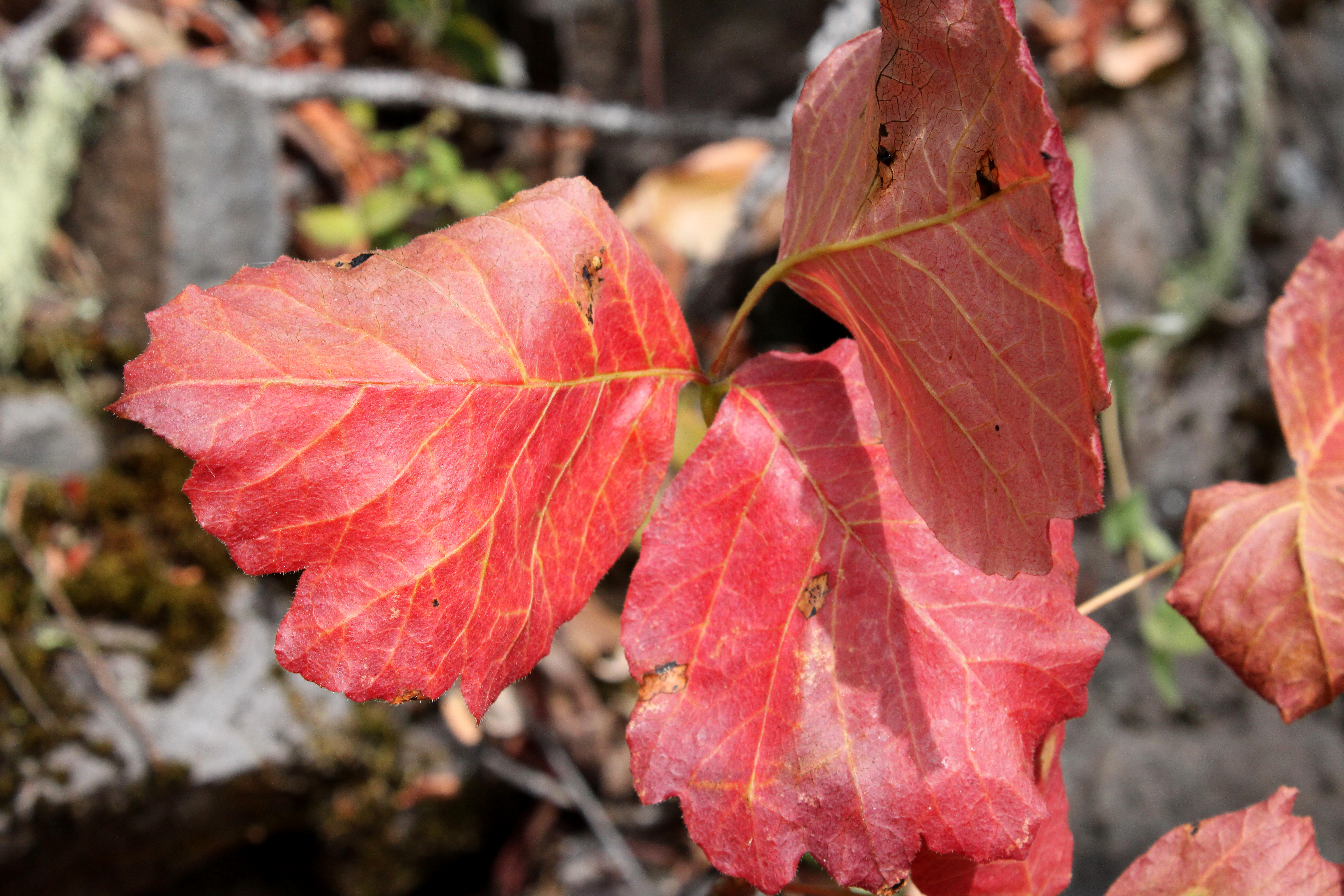
Poison oak was easy to spot with its red leaves

For more photos of this hike, please visit the Flickr album.

Saturday, March 27, 2021

Kentucky Falls


It's not funny if you have to explain the punchline. As we were lacing up our boots at the Kentucky Falls Trailhead, I offered up the factoids that Kentucky Creek was flanked on either side by Roman Nose Mountain and Mount Popocatépetl, adding that the three place names were a geographic tribute to primitive cultures and incomprehensible dialects. What I got back, instead of wry chuckles, were perplexed looks and several earnest and sincere "Wow, really?" questions. My hiking companions got it when I, my voice laden and dripping with sarcasm, answered a question with a question "Have you ever spoken to anybody from Kentucky?" I may have lost my entire Kentuckian readership with that one but hey, it's probably only one guy anyway.

All life should be like a walk in the forest

Even though Kentucky Falls was the main reason for our outing, this hike was mostly all about the forest. The morning sunlight was slanting through a cathedral-like grove of tall trees arching overhead like so many ribs in a Gothic basilica. You couldn't help but tilt your head heavenward like an awestruck pilgrim entering Notre Dame (or any other cathedral of the era) for the first time. The green glow from the trees, ferns, and moss was pervasive and small thumb-sized birds made fist-sized twitterings as they scolded hikers celebrating a decidedly green spring day. Below all the tall trees and twittering mini-birds, tri-petaled trillium flowers added their own special grace and elegance to the reverential scene.

A small but boisterous piece of Kentucky Creek

We were hiking nearly at the bottom of a canyon carved over the epochs by Kentucky Creek. When not in a truly sublime forest, we found ourselves hiking on a trail etched onto exposed cliff faces, all colored green by the ever ubiquitous moss. Initially, the stream pleasantly coursed through the trees before picking up speed. In a practice run for the big leap at Upper Kentucky Falls, the creek jumped off several ten-foot ledges, each a worthy cascade in its own right. And speaking of big leaps, I didn't do any. Eventually, Upper Kentucky Falls hove into view as the path switchbacked down to the waterfall's splash basin.

In all its Kentuckian glory

Roughly about 100 feet tall, Upper Kentucky Falls was carrying a large volume of water, seeing how Kentucky Creek was swollen with spring runoff. The sound of the falls echoed throughout and we all stopped to contemplatively admire the picturesque cascade roaring in the shady canyon. Here on the west side of the distant Cascades Mountain Range, waterfalls are about as rare as a mosquito in late July, which is to say they are not rare at all. But even so, Kentucky Falls is arguably one of the better ones.

Moss rules this forest

After the requisite Upper Kentucky Falls view-soak and photo-op combo, it was more of the same as the trail continued to descend down toward the confluence of Kentucky Creek and the North Fork Smith River, our intended turnaround point. The forest was still eminently sublime, the morning light remained poetic, and the trail was flanked with elegant and graceful pale white trillium flowers to go along with yellow woodland violets, and white-to-pinkish oaks toothwort blooms. All of the floral colorations were but mere specks against a green backdrop of either moss, ferns, or salal.

Bird's nest fungi, en masse

Roughly halfway between the upper and lower falls, the trail crossed over a small creek via a rustic wooden bridge covered with bird's nest fungus. Generally seen on the ground or on decaying twigs, these tiny fungi are actually shaped like a bird's nest, sometimes containing small brown "eggs" which actually are spore capsules. 
Because of their small size, these fungus are not readily spotted when we hike by them, but the bridge here was absolutely covered with the diminutive fungi and much macro-lens photography ensued.

A beetle takes a pollen bath

About a mile below the upper falls, Kentucky Creek drops off another rocky ledge at Lower Kentucky Falls, made further notable that the lower falls and North Fork Smith River Falls tumble side-by-side over the same ledge. The scene is epic and I had every intention of hiking down there until a large chest-high log blocked the way with no means of bushwhacking around it, seeing as how it was sited on a steep near-vertical slope, and at right angles to the trail. The idea of swinging my leg and fresh hernia surgery incisions over that daunting obstacle made my "little boys" crawl back up into my abdomen in cold dread, so uncharacteristically I did the right thing and called my hike over at that point, darn hernia anyway.

Rustic footbridge over a small creek

This would be the last hike under the stultifying restrictions of the surgeon's dictates. After today, me and the boys are free to hike as we see fit, although I've been warned to listen to my body which doesn't really work, because so much of hiking is ignoring what your body tells you anyway. So, while my legs felt a little unfulfilled, I still wound up following the doctor's orders without really meaning to, thanks to a wayward log. 


For more photos of this hike, please visit the Flickr album.


Saturday, March 23, 2019

Payette Trail 3/2019


A month prior, I had hiked the Payette Trail to familiarize myself with the route and thereby imbue myself with a certain air of infallibility that comes with knowing where you are going. But then again, my comrades know me already and their opinions of my leadership, good, bad, or indifferent had been cemented into their minds long ago. At any rate, this was the day to actually lead a group on the hike. 

Good weather to start with


The weather gods were not kind to me. A pretty good rainstorm was forecast and accordingly, only three hikers (regulars Diane, Brad, and Lindsay) decided to go on a Richard Hike. Well, at least that made carpooling a whole easier. However, when we arrived at the trailhead, patches of blue sky appeared here and there in the cloud cover and the air was decidedly dry. Would our good fortune hold out?

It's a beautiful day, for the time being
Well, for the lakeside contour portion of the hike, yes it would. We had a rather enjoyable hike in dry weather and I daresay, we even enjoyed that wonderfully warm sensation of sunlight on skin here and there. Unfortunately, the weather forecast came to fruition just as we sat down for lunch at the intersection of the Payette and Osprey Trails.

Here comes the rain!
As we ate, the blue sky disappeared, overtaken by a fast-moving wall of ominous looking clouds. A gusty breeze announced the presence of the rainstorm and we'd have a steady rain falling on us for the rest of the hike. Accordingly, we all opted for a shorter route back by grabbing the Osprey Trail and now I was back in unfamiliar territory. So much for preparing the route ahead of time!

Totem in the middle of the forest
The Osprey Trail basically climbs up and over the peninsula lying between the French Gulch and Squaw Creek arms of Applegate Lake. Accordingly, the trail headed uphill at a moderate grade, which warmed us up sufficiently enough to ward off any cold from the inclement weather. After a mile or two, we arrived at Dagelma Trailhead, the parking lot empty because apparently, we were the only people in all of Oregon out for a hike on this wet day.

Lindsay hops over a trail obstacle


At least all the bad uphill stopped at the Dagelma Trailhead and it was all downhill from there. Our only travail (besides the steady rain) were a couple of large trees lying across the trail and we got to practice our clambering skills getting over them. At least no trees fell nearby, like in my previous outing on the Payette Trail. We unanimously agreed it had been a fine walk and we pitied all our friends who didn't go hiking out in the rain on this day.

Spiders from Mars
For more photos of this hike, please visit the Flickr album.