Showing posts with label beach. Show all posts

Saturday, September 10, 2022

Lola Lake Loop (Oregon Coast Trail)


Because Facebook knows everything about me, on my feed I received a blurb about a coastal birding club (it may have been the Audubon Society) going on a short 2.5 mile nature walk around Lola Lake, located somewhere on the coast near Pistol River. They may have even called it a hike. Anyway, I'm all like "Birds? Meh!" followed by "NEW TRAIL!!!" After a short investigatory consult with the Internet, I ascertained that it was possible to reach the beach from Lola Lake, and thereby accrue a more proper hike mileage by walking north to the mouth of the Pistol River. A
t that point, I was all in.

You need to keep an eye out for this guy to find the trailhead

The trailhead was not that easy to find, and I initially drove past without realizing it. Coming back the other way, though, a post with a blue Oregon Coast Trail marker affixed to it was clearly visible by the side of the roadway and in short order, I found myself hurriedly lacing up my boots at the trailhead, eager to get started.

A well-maintained path wanders through the forest

The Oregon Coast Trail quickly left the busy highway behind, dipping into a typical lush and shady coastal forest. My initial impression was how nicely maintained the trail was. The brush had been cut back from the trail, there were no fallen trees to step over, and clearly legible and informative signs were posted at every intersection. I'm so not used to this!
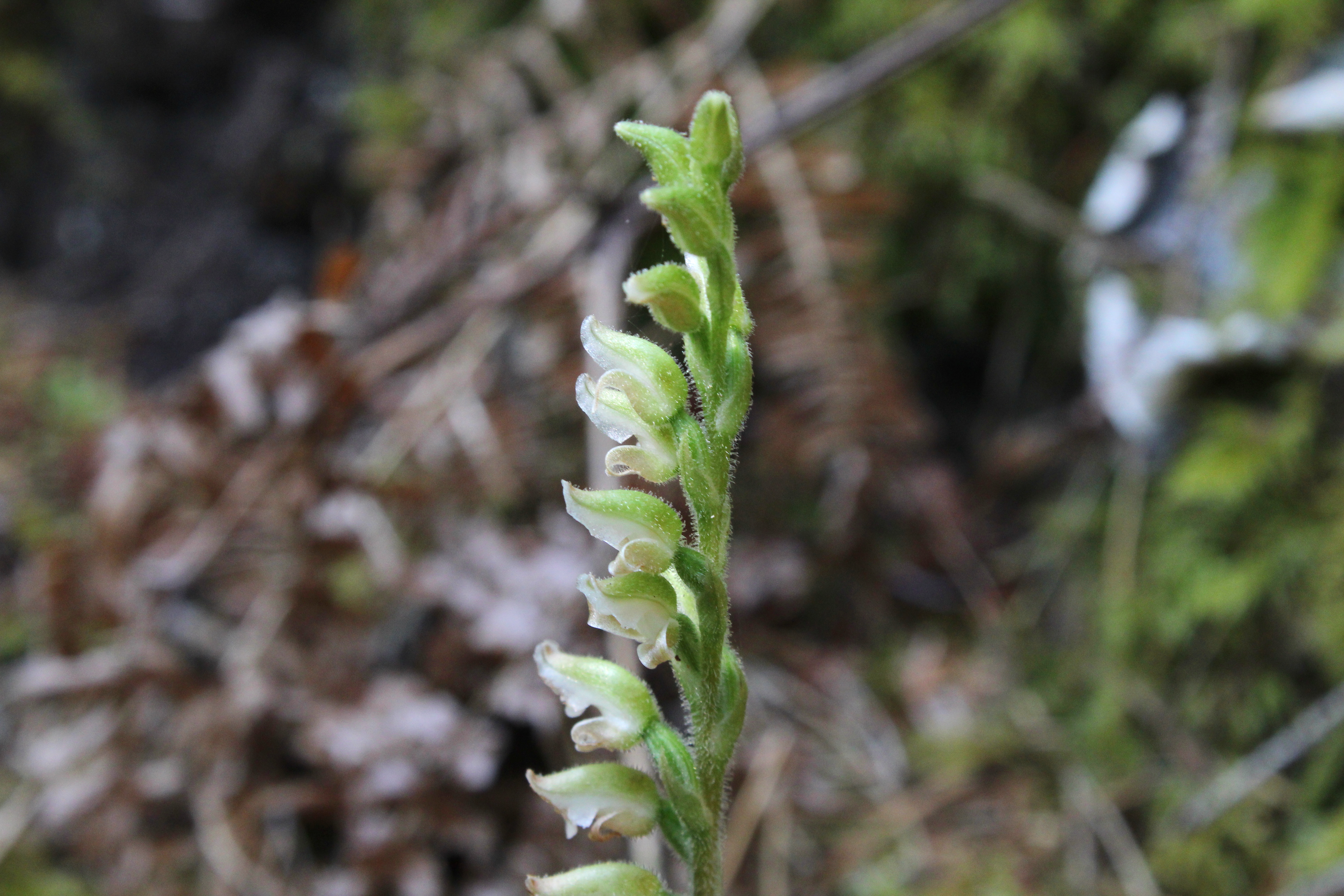
Wintergreen was clearly in blooming season

The first intersection offered the choice of hiking to the beach or looping around Lola Lake. Since I'd never been, Lola Lake it was. The forest on the loop trail was heavily mossed and a healthy population of ankle-high wintergreen was busy flowering on the forest floor, enthusiastically hoisting aloft stalks of white flowers like so many football fans waving their pennants. Mushrooms, ferns, and moss likewise abounded, feasting on the decaying biomass so prevalent in a coastal forest.

Lola Lake in all its grassy glory

If Lola Lake were to be the sole reason for this hike, then I'd be bitterly disappointed. The lake had dried up and gone to meadow. Presumably, the lake is actually a lake when the spring rains fall but this late in summer, there wasn't any water. That wasn't a deal-breaker though, for the erstwhile lake still was a nice meadow and there's no complaining when you hike to a brand new place anyway.

The trail begins to transition from woods to dunes

After executing the lake loop, it was then a right turn onto the beach trail which continued the wander through dense coastal woods. Eventually though, the dirt path became a sandy track and the trees thinned out, giving way to beachgrass and dunes. Common yarrow and pearly everlasting were in bloom among the omnipresent beachgrass, the wildflowers busily entertaining bees, butterflies, small wasps, and incredibly handsome hikers-cum-photographers.

View to distant Cape Sebastian

Odd and totally out of place amid the sand and beachgrass was a large castle-like rock formation. The rock was adorned with striations and layers of tan and ocher hues and tints. A short scramble to the tip of the rock yielded a view to distant Cape Sebastian so I had to stop for a bit and do some photography before continuing on.

Sand Creek snakes across the sand

The trail reached the beach just north of Crook Point, whose rocks and islands are an effective deterrent to hiking further south via beach. Sand Creek snaked out of the grassy dunes to sassily sashay across the beach to become one with the ocean. The surf crashing onto the craggy rocks of the scenic point entertained and to the north, stretched a long beach with Cape Sebastian looming many miles beyond.

View to the north

I never made it to Pistol River like I had intended. Unfortunately, the wind could be best characterized as belligerent, bellicose, and brawly. I'd venture to guess that I was getting cuffed about by a steady 40 miles-per-hour blow. The stiff breeze peeled spindrifts off the incoming waves and I felt fortunate it was blowing at my back. However, at some point on the return, I'd be hiking into it, my incredibly handsome face bearing the brunt of the wind-driven sand. The question was whether I wanted to endure Mother Nature's free dermabrasion and exfoliation treatment for 2.5 miles, 1 mile, or some distance in between. I eventually chose to turn around after a mere mile of beach walking.

An incoming wave wants to eat me

As anticipated, it was a stinging and bracing walk back to Crook Point with eyes all teary, but on the plus side, I don't have acne anymore if only because you can't have acne without having facial skin. Needless to say, it was much appreciated when the trail left the beach and entered the sheltering woods.

Low growing fleabane prettified the sand dunes

I really didn't any pay attention to any birds on his hike. In fact, I'm not even sure there were any birds for me to pay attention to. However, I'm nonetheless grateful to the birds for exciting the birding crowd to the point they put on the hike I had mentioned earlier. My first visit to this particular section of the Oregon coast would not have happened without the birds and birders. Happy squawks, chirps, and keening cries to all concerned.

Islands near Crook Point

For more photos of this hike, please visit the Flickr album.

Wednesday, December 1, 2021

Blacklock Point


Of the six hikers in our little group, only I knew the secret route to a hidden epic viewpoint overlooking the Oregon coast north of Blacklock Point. Naturally, it was incumbent upon me to lead us all on a scrubby and cliff-hugging journey to Mother Nature's observation deck. As we worked our way through cruel growths of scratchy brush, somebody asked "Are you sure you know where you are going?" and my cruel heart was immediately gladdened. Nice to know I still have the touch, even on a hike that I was not formally in charge of.

The Oregon coast calls, and I must go

I've been to Blacklock Point like a million times or so and have had plenty of miles in which to experience Blacklock's many moods, ranging from icy windstorms to stifling heatwaves. Today's offering was sunny and mild, with just a hint of windy bluster (just like me!). Given the cool and wet conditions so prevalent on the coast on most any given day, we gratefully accepted the bright and breezy bounty from the weather gods.

The difference between evergreen and perennial, illustrated

Things got off to a little bit of an awkward start when I tried to find the path running behind the runways of nearby Cape Blanco.  A faint track overgrown by thorny gorse discouraged most of us from taking the loop route to Floras Lake and after a brief discussion (mutiny, really) it was decided by majority vote that 1) the hike would be an out-and-back and 2) nobody should follow me down any further overgrown paths that might otherwise arise during the hiking of this hike.

There were whole entire worlds inside the puddles

The trail from the airport to the Oregon Coast is an old road and as is an old road's wont, potholes had formed on the dirt road. And as are potholes' wont, over time they had grown larger and then had filled up with water during recent rainy weather, testing hikers' mettle and determination both. And as are hikers' wont, an unofficial system of footpaths were illegally braided through the brush for the express purpose of walking dry-footed around the bodies of water. While I'm not particularly averse to hiking with wet feet, some of those puddles were large enough to host a yachting regatta, so we used the detours like everybody else.

Light beams slice through the forest

The Oregon Coast Trail basically contours along and atop the coastal cliffs keeping the ocean from overrunning the rest of Oregon. Apart from occasional bushwhacked-to overlooks, most of the hiking was through dense coastal forest, the trees twisted into phantasmagorical shapes by the near-constant sea breeze. It was both dark and light in those woods, with sunbeams slicing through the deep shade like giant light-swords wielded by angry samurais. The air was slightly misted which provided some heft to the sunbeams and I soon lagged behind, completely engrossed with the light show.

The footing was treacherous on this bridge

After a walk of several miles, made slightly longer by side trips to several coastal overlooks, the trail dropped down to a small creek. There usually is a small wooden footbridge spanning the creek but given the proclivity of winter rains, the span is often transported downstream in one piece or sometimes in many pieces. On this day, the rustic bridge was found intact but downstream. A test step revealed that the small span was somewhat slippery so I opted to just get across the creek with one long-legged stride.

Hiking on a beautiful day

We ate lunch on the beach, sitting on driftwood logs while debating whether to continue walking on the beach all the way to Floras Lake. The tide was receding but the sea was still an angry seething cauldron of turbulent water and there was not a lot of beach between watery maw and unyielding cliffs. Several years ago, a hiker and his young child had tragically lost their lives there so our consideration was indeed somber and serious. It was eventually decided to turn around and catch Blacklock Point on the return leg.

Life on the edge

So, it was back the way we had come, through the same old dark forest accentuated by the same old bright sunbeams. Halfway back to Blacklock Point, I led my gullible and trusting comrades on the previously mentioned bushwhack venture to the epic viewpoint. From atop an ochre colored bluff, cliffy ramparts marched in stately procession for many miles north before fading into the misty distance. Waves continually broke at the edge of the vast blue ocean and nearby rocky Battleship Bow imposed its bulk and will upon the beach below. As a bonus, a small waterfall trickled over the cliff's edge and splashed onto the beach below. The awesome scenery was well worth the many aspersions cast in my direction to go along with the scratches.

See Blacklock Point?
Me, neither!

At Blacklock Point, we only had a few minutes to enjoy the view of the craggy point and its chain of rocky islands. While we were there, a fog bank rolled in from the ocean and within minutes, Blacklock Point was just a ghostly outline in the mist. I'll have to add thick fog to the catalog of weather conditions I've experienced at Blacklock Point. From the point, it was a perfunctory hike back to the trailhead, bypassing the familiar potholes and puddles. Hearts were gladdened by today's endeavor and also by a stop in Bandon for some restorative ice cream.

The day completes the transition from blue to gray

For more photos of this hike, please visit the Flickr album.

Wednesday, November 17, 2021

Cooper Creek Reservoir


The day before this little outing at Cooper Creek Reservoir, I had hiked on the Bolt Mountain Trail under mostly sunny skies and relatively warm sunlight. The one exception to the summery vibe occurred when I rounded the north side of the mountain, where the temperature dropped precipitously in a hint of things to come this winter. Fortunately, that frigid little interlude was relatively short-lived as I emerged back into the bright sun after a mile of hiking in the cold. Contrast that with this day's hike along Cooper Creek Reservoir where the gray day was as unflinchingly cold as a predator's calculating gaze. Seemed like, at least on this day, the entire world was on a cosmic north-facing slope.

A very calm and quiet lake and morning

This was a hike among friends and the five of us began hiking in easy companionship across the lake's dam, the cold air slapping our rosy cheeks (of our faces, to be clear) like an outraged diva. Winter cometh and noses runneth, and I hadn't brought gloves or a knit cap so right away my fingers went numb and my head went dumb, thanks to the frosty temperature. Because fingers are not overrated, my hands took alternate turns at some quality pocket time, and cold digits were grateful until their time in the warm pocket was up. The runny nose problem was taken care of with perfunctory swipes from the back of my non-pocket hand and I wonder why nobody will shake hands or fist-bump with me.

The lake needs to kick its smoking habit

All members of our party were Cooper Creek regulars since the lake is so close to Roseburg and we get out there fairly often. Accordingly, it was readily apparent to all concerned that despite the recent runs of rain, the lake level was pretty low. Exposed shores or not, the lake was as preternaturally calm and serene as a monk in deep meditation. The scenery was in grayscale though, seeing as how the sky was overcast, and the dark waters of the lake could only reflect back the same overall grayness. Vapor emanated from the black water of the lake as we hiked by, ourselves uncharacteristically matching the tranquility out of respect for the peaceful scene. We also matched the whole vapor-emanating thing too, as our breaths hung in the still air like so many miniscule cumulonimbus clouds.

Salal contributes some local color

The forest surrounding the lake was damp and sodden thanks to the aforementioned recent rains. There were still some vestigial remnants of autumn in the form of colorful blackberry, salal, and wild rose leaves; along with occasional yellow maple leaves still clinging to life and mother tree alike. Where there were maple trees, the path was carpeted with dead leaves underneath and our boots churned the leafy detritus into the muddy trail. The overall dampness on the trail tread created a few unexpected mud-ski and skating "opportunities" for hikers every now and then.

Trail through a damp forest
next to an even damper lake
The morning had warmed up a degree or two as we hiked along the quiet lake but the exertion of hiking was the primary reason for warming erstwhile cold bodies. The trail around Cooper Creek Reservoir is not particularly rugged but does serve up a regular dose of up and down hiking. So, winter cometh but hiking warmeth uth. Tho thorry.

A meadow forms where there once was a lake

Cooper Creek Reservoir is long and narrow, almost fjord-like, and the trail rounded the Cooper Creek inlet end after a couple of miles. As mentioned, the lake was low and the retreating shoreline had been supplanted in turn by a rather vigorous meadow of tall grass, mostly dry and desiccate this time of year. Now heading back in the general direction of where we had started from, we stopped for a lunch and laze at a convenient picnic table near the boat ramp.

The forested part of our hike

At this point we discussed options for the remainder of the hiking route. We could turn around and go back the way we came or we could continue on and circumnavigate the body of water. The circumnavigation could be completed by either a road walk or by bushwhacking along the shore. John, Patty, and I (namby-pambies!) opted for the road walk, which I'd never done before, while honorary he-men Jennifer and Gayle (and canine friend Sammy) opted to bushwhack around. All routes were soon perfunctorily hiked and we all met up at the trailhead in short order.

Blackberry does not have black leaves

The cold conditions on this hike were not necessarily dire but they did serve as warning for what is to come. Accordingly, my day pack has since been restocked with winter essentials such as crampons, mittens, ski cap, balaclava, and a flask of scotch which will almost guarantee that none of those items will ever be needed (excluding the scotch, that's always useful) during a winter hike. That's just how it works. 

Almost too quiet!

For more photos of this hike, please visit the Flickr album.

Sunday, December 17, 2017

Cape Arago Night Hike 12/2017

Merry Christmas, everybody! Of course, it's late January as I type out this missive so a very, very, very belated "Season's Greetings!" to all my readers (assuming I have any). I suppose I could take the position that I am seasonally greeting far in advance of next Christmas but everybody knows I'm not that organized. Anyway, the reason Christmas came up is that the hike I'm writing about today is my semi-annual Christmas night hike to Shore Acres and Cape Arago. And by "semi-annual", I mean not quite every year, it sort of depends on my mood, the weather, and whether my followers have sufficiently sung enough laudatory praises and accolades. Whining helps, too.

Cape Aragaliens
This year, enough sycophantic-toned requests for this hike rolled in, and it looked like the weather was going to give us a break. Since I was in the mood too, it was a perfect storm of proper hiking conditions and this hike was quickly penciled onto the hiking calendar. Unlike years past, the Roseburg contingent showing up for the hike was sparse, consisting of me, Daweson, Diana, and Brad. However, a like-numbered crew from Coos Bay showed up, bringing our numbers up to a more proper 8 hikers.

The spectacular coast at Cape Arago
Strange though, when we arrived at Sunset Bay at the duly appointed hour, it was just us Roseburgians. Turned out, some of the Coos Bayliens (ha, just made that up!) had parked further up the large parking lot and Rachel, who was parked right next to where we would park, wandered over there to talk to them. While they were all prattling their Coos Bay prattle, we were industriously lacing up our boots and setting out on the trail. Thinking we were running late, our Coos Bay friends waited another half-hour before Rachel took charge and led them on a very fast hike to catch up with us, which they did at Cape Arago. I believe that was the very first time Rachel ever led a hike and she did such a fine job, she earned a spot on the "list" of upcoming hike leaders. Of course, her biggest fear was that we would not be at the cape and she'd have to lead her people back in the inky black of night. 

Phatasmagorical rock formation
My grandson Daweson is a growing lad, so his boots fit too tight and he popped some debilitating blisters. Darn kid needs to stop growing so fast! Because of the blisters, he had to put out at Shore Acres and Diana stayed with him, so it was just me and Brad continuing on to Cape Arago. As we hiked along the rugged coast, the sun was sinking low in the late afternoon and waves lapped up against the shoreline cliffs. Brad made some comment about large waves and I responded with a dismissive "Pssh", explaining to him that this was low tide and he should come back during high tide to see what real waves looked like.

Simpson Beach was a sea lion sick bay
Simpson Beach was under quarantine as a sick sea lion was recuperating on the sand. Apparently there is an outbreak of leptopirosis affecting sea lions all along the Oregon coast. Respecting the wishes of the park, we merely sideswiped a corner of the beach as we continued hiking south to Cape Arago. And by the way, the following Monday I called in sick with leptopirosis and they bought it!

"You go first!"
The weather gods were so very kind to us at Cape Arago. It had been a semi cloudy, semi-sunny day and a raft of clouds hovered overhead, ready and fully prepared to squelch a would-be spectacular sunset. But when the sun slipped below the clouds, the sky and sea turned brilliant orange while appreciative hikers oohed and aahed. I was fully engrossed taking pictures of the sunset show when somebody smacked me in the back of my head and said in a British accent "There you are!" And a "Happy Trails!" to you too, Rachel. 

Ooh...aah!
There is no sunset like an Oregon coastal sunset and we enjoyed the show as we pieced together the events that led us to hike in two separate groups. As the sun dropped behind the horizon, we gathered up our gear and headed back the way we had come. We enjoyed the view of the coast as day morphed into night and finally, I whipped out my puny headlamp and officially commenced the night hike portion of this hike.

Rachel models the proper night hike attire and attitude
Suddenly, behind me, there was a huge blinding light that illuminated virtually all of southern Oregon. In fact, the astronauts in the space lab orbiting the planet reported an unusual "light event" on the west coast of the United States. Jets were scrambled to find the source and Area 51 went to threat level "Bright Light". Well, it was just Brad and his atomic-powered headlamp. I'm not sure how many lumens it was putting out, but it was bright as a miniature sun, overpowering all the headlamps in front of him. Plus, it kept us warm as we hiked through the cold night.

One small piece of the Shore Acres gardens
Besides a spectacular Cape Arago sunset, one other reason for doing this hike at night during Christmas season is to cruise through the Shore Acres gardens. Shore Acres was once the baronial estate of timber magnate Louis J. Simpson. The actual lordly mansion at Shore Acres burned down and no longer exists but the caretaker's cottage is still there, presiding over some stately gardens. And this time of year, the gardens are bedecked with Christmas lights of every color possible within the visible light spectrum. A plethora of kinetic light displays offer up flying pelicans, leaping frogs and splashing orcas while Christmas carolers serenade visitors from a brightly lit pavilion. I was still wearing my headlamp (turned off) and a woman asked me where the cave was. Seriously, that really did happen.

Fierce creatures
After enjoying the lights in the garden it was time to head back. There is a point where you have to cross a road and find a faint path to the main trail but with the assistance of Brad's atomic light, it was unusually easy to find. As we walked through a pitch-black forest I was telling Daweson about how you can often see eyes reflecting back at you when you wear headlamps. And right on cure, four eyes were floating in the forest ahead of us. Upon closer inspection it was a mother deer and her fawn. They disappeared in a puff of smoke when Brad shined his atomic light beam on them.

Daweson models his teenager's angst
Anyway, a good time was had by all, except for maybe Daweson's right foot. We'll have to do that again in a couple of years and Merry Christmas, everyone!

Merry Christmas!
For more photos of this hike, please visit the Flickr album.