Monday, June 10, 2013

Warner Peak Road

OK, so I use this blog to tout all my wondrous successes in hiking. To be fair, I suppose my failures should also be equally touted and this hike would be one of those. However, if you are going to do the hiking equivalent of a belly-flop from a high dive, you might as well do it in a beautiful place like the Warner Peak Road on the way to Warner Peak, the highest point in Hart Mountain Antelope Refuge.  

A nice start to the hike
We got off to an early start, grateful the cool morning kept persistent mosquitoes abed while we ate breakfast.  Hopping into the car, we drove the wild and barren Blue Sky Road to the southern end of the refuge.  We were entertained by a badger mom and her pup shuffling across the road, for some reason I was reminded of work.  And of course, we saw plenty of pronghorn antelope as was customary during our stay in the refuge.

I want no guano

The Blue Sky Road terminated at the hilariously named Guano Creek which resembled nothing like the name suggested. It was green, shady, lush, and absolutely devoid of guano. Of course the Guano Creek green belt was more like a Guano Creek green string as the vegetation did not stray very far from the creek, the dry hills remaining the purview of the ubiquitous sagebrush.

Post Creek
Climbing gently through the pines, we actually hiked across an honest-to-goodness creek, complete with a large trout swimming around in panic at our arrival. Post Creek, meet your hikers and hikers, meet your mosquitoes. We learned not to stop in any one place too long as we continued through the sagebrush with a nice overlook of surprisingly green Post Creek Meadows.

A grave occasion
There were a couple of grave markers for two fallen soldiers, presumably they perished fighting Indians. They died so young and so far away from home and  we paused in somber reverence for them and for the natives that also perished when the two cultures collided. I have nothing funny to say unless the soldiers were slain by mosquitoes, in which case the soldier's demise then becomes utterly hilarious.  

Will the uphill ever end?  No!
A log gate signaled the start of the official Warner Peak Road and unofficially the start of some pretty steep uphill walking. It's also where my travails started. I had been feeling not-in-shape for some time due to my injured wrist curtailing a lot of my customary exercise regimen. Plus it was hot and plus we were hiking near 7,000 feet of elevation. So due to one of those factors or maybe due to all, my legs were tired from the get go, my head hurt, and I wasn't sure breakfast was going to stay down or not. 


View out to the great beyond
I plodded upwards as best I could and Merle kept an eye on me, probably out of pity. Or maybe he did not want to carry back to the car what remnants would be left of me after the mosquitoes finished. But the scenery was just too magnificent to cark it (Australian for heart not beating any more) on this day. To the south, clouds formed over a vast expanse with mountains and canyons jumbled in capricious mayhem by the desert gods. Upslope, balsam root colored the mountains yellow against a cobalt sky.


Ridge on top of Hart Mountain


At a saddle looking across a massive and rugged canyon to a ridge with snow patches and a thick forest, I called it quits. Warner Peak was several miles away and about 1,000 higher than the saddle. Merle and John continued on, attaining the summit of Warner Peak and later regaling me with tales of views, mountaintop mosquito swarms, and an eerie flock of seagulls just watching.

Cloud with noise and attitude
Meanwhile, as I was descending back to the car, thunderheads formed over the desert plain and as the clouds swept near, rumbling could be heard. On the drive back across the wild refuge hinterlands, black ribbons of rain trailed from clouds like feathery tentacles dangling from jellyfish. Bolts of lightning zigzagged their way to the ground far away enough for us to enjoy the show without fear of becoming a glowing conduit of electricity.

Canyon lands in the distance
So, while I was not able to get up to the Warner Summit, I remain somewhat philosophical about the aborted hike.  First of all, Warner Peak is unfinished business and I now have a good reason to return to Hart Mountain.  Also, part of hiking safely is knowing when not to hike and in that regard, my failure was an unmitigated success.

Clouds, painting the sky


For more pictures (I was dying but still taking pictures!) visit the Flickr album.   


Sunday, June 9, 2013

Poker Jim Ridge and Petroglyph Lake

After a cool first night at Hart Mountain Antelope Refuge, we slapped at mosquitoes the following morning as we prepared to go hiking. On the skyline of Adams Butte, I could make out the silhouette of a pronghorn antelope sprinting up the butte's slope. Now, there's something you don't see on the west side of the Cascade Mountains!

Flat is as flat does
The hike along Poker Jim Ridge is a cross country walk through the sagebrush and the going was not particularly speedy as the rocky ground made for tedious walking. Since there were no trees, navigation was simple: keep the ridge rim within sight on the left side and don't step off, the next stop would be 3,000 feet below!

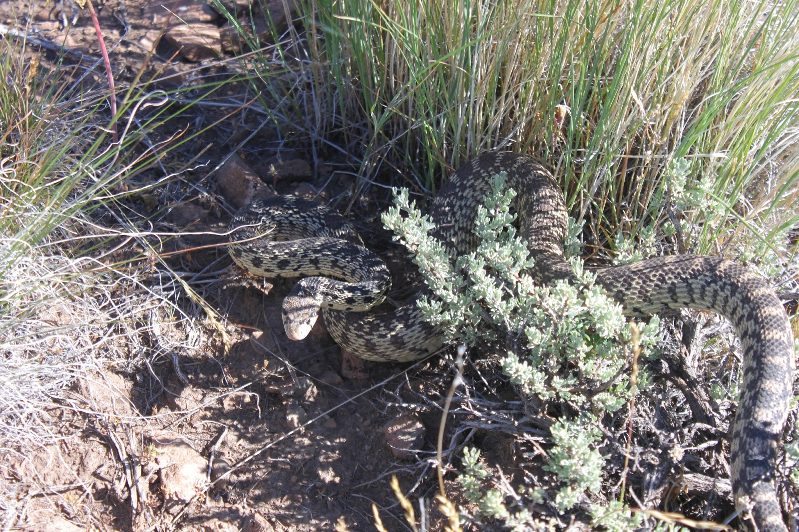
A snake with anger management issues
At the start of the hike, John found a large gopher snake that was not too happy to see us. Coiled up in a defensive posture, the snake hissed and vibrated his tail, it wanted us to think it was a rattler. After taking a few pictures of the snake, I moved the toe of my boot into its personal space and my boot was subsequently attacked. Despite knowing the snake was harmless, I still jumped.

No Dollie, I would never drive your car on that road
From Poker Jim Ridge, the views were tremendous. Directly below was Campbell Lake and its other Warner Valley lake friends:  Lakes Flagstaff, Upper Campbell, Stone Corral, and Turpin. Bluejoint Lake, the northernmost  lake, was all dried up but we could see where it had been. Further south were Hart Lake and the small itty-bitty town of Plush, both flanked by the rock wall that is Hart Mountain. Beyond the Warner Valley were the desert mountains, most of them brownish in color.  Truly a vista for the ages.

Petroglyph Lake in the distance
We worked our way up to a small high point on the ridge and enjoyed lunch in shade provided by a copse of juniper trees. We could see for miles and miles and two small lakes glistened in the vast expanse of the refuge, one of which would be our next destination.

John sets sail to the lake


We dropped off our knoll and headed overland to Petroglyph Lake which disappeared from view like a mirage as we lost elevation. Not to worry, though, we kept going in the same direction and eventually happened upon the lake, hidden in a natural bowl in all the sagebrush.

Colorful Petroglyph Lake and don't drink the water
Surprisingly, there was a lot of color at Petroglyph Lake, seeing how it was ringed by tansy-leaved evening primrose which was blooming bright yellow in broad daylight, despite its name. Green grass ringed the lake and reeds hugged the shoreline in the milky waters of the lake. Petroglyph Lake, as is the case with so many of the lakes in this area, has no outlet so the waters tend towards the muddy and alkaline.

Petroglyph
At one end of the lake, there was a rocky cliff and we explored the cliff, taking in the petroglyphs that give the lake its name. I tried to be respectful but one of the glyphs sure looked a lot like Sponge Bob. We wondered if the glyphs were art, storytelling, advertisements, or graffiti. I supposed it might have been the equivalent of what you see in our public restrooms: "For a good time, send smoke signal to Running Turtle" or "Here I sit all broken-hearted, tried to poop but only rock-arted".

Merle and Richard try to keep pace with John
At any rate, we left the lake and headed across the flat sagebrush plain to our car. Apparently there was a pronghorn baby hidden in the sagebrush that took off running in panic at our arrival. Pronghorn can run at speeds up 60 mph and it was impressive to see the little guy speed across the same rocky plain we were struggling to walk through. We also got to see a mother with two pups(?) in tow, eventually joined by enough other pronghorns to formally constitute a herd.

Fading light on Hart Mountain
So back to camp we went for a post-hike soak in the hot springs. We did learn to avoid "The Naked Guy" after this particular evening soak. After the rustic Jacuzzi, we were treated to a superb sunset and the end to a productive day.

Spectacular sunset
For more pictures of this hike, stop by and visit the Flickr album.


Saturday, June 8, 2013

Hart Mountain

Hart Mountain National Antelope Refuge is only about 190 miles from Roseburg as the crow flies.  However, it took us all day to get there as Hart Mountain is not an easy place to get to, being situated in the middle of the Oregon outback with its wide open spaces and a notable paucity of roads, paved or unpaved. After a full day's 400 mile drive, we (John, Merle, and your intrepid blogster) arrived at the Warner Valley and Hart Mountain itself.

The reason for the refuge
By this time, we had left any semblance of forest well behind us and entered an arid world of sagebrush and wide sweeping vistas of bare mountains and vast valleys in between. Shortly before arriving at the handful of buildings and homes that comprise the hamlet of Plush, we actually espied a lone pronghorn antelope eyeing us disinterestedly as we drove by. Safe to say, we were not in Roseburg anymore.

Hart Mountain rises from the Warner Valley
Many epochs ago, seismic processes uplifted a block of the earth's crust and the net result is that the massive wall on the west side of Hart Mountain was pushed up an intimidating 3,000 feet above us as we drove on the dirt road hugging the mountain's base. The mountain flanked the Warner Valley and even though we clearly were in the arid desert, the valley floor contained a series of large lakes and marshes known collectively as the Warner Lakes. Small creeks tumbling seasonally down the mountain's face had carved deep and incredibly rugged canyons over time. The slow pace required by the rough road allowed us to soak in the views in typical tourist mouth-agape fashion.

Some of the Warner Lakes
Things got way cool when the road peeled away from Campbell Lake and proceeded to climb away from the valley and lakes. The Warner Valley wetlands lay at our figurative feet with view of lake after lake with the barren Coyote Hills chasing the equally barren Rabbit Hills in perpetuity on the other side of the valley. The road inched up the Hart Mountain wall and we must have looked like a tick climbing up a pant leg to anyone looking down.

We set up camp and the mosquitoes are happy
We set up camp at the primitive Hot Springs Campground. Despite the primitive part, the camp was one of the better camps I've camped at. Little Rock Creek trickled through a relatively green valley flanked by willows with expansive views of the sagebrushed hills and snow-patched Warner Peak. We set up camp in the trees where we were isolated from the semi-constant wind. Unfortunately, there was no isolating us from the mosquitoes lurking along the creek. And best of all, there was a genuine bona fide hot spring that became a regular post-hike destination during our stay.

Awww...isn't he cute?

For more photos of our first day at Hart Mountain, please visit the Flickr album.  


Saturday, June 1, 2013

Azalea Lake backpack

This was a hike of firsts: the first backpack trip this year, the first hike with my new hiking boots, and my first blisters from my new hiking boots. Not all firsts are good things, vis-a-vis the blisters and the first blackfly bites of 2013. This was not my first visit to Azalea Lake however, but it was my first time to the small alpine lake this year and it was also the site of the very first ever Richard-and-Dollie backpack trip. I'm not sure what all these firsts mean but the scenery was certainly first rate on this weekend overnighter.

Starting out
Ray and I had camped at the trailhead on Friday night which translated to an early morning start as we hit the trail just before 7:30. That might have been the first time in my entire life I've done anything before 7:30! At any rate, leg muscles were soon burning after a brisk uphill climb from the trailhead.

Fir Glade
What goes up must come down, a truism that does not always hold true in hiking, but in this case the trail actually did drop down as we hit Fir Glade in just over a mile. Fir Glade is a large and picturesque meadow and it was peacefully quiet early in the morning. We were too early in the season to enjoy the wildflower show as the hellebore was only several inches tall in a sign that snow had just recently melted. A small creek trickled musically through the meadow and we crossed over it on a footbridge.

Thompson Creek Pass, so far away...
From here, the trail climbed steadily through the forest. The trees here are not so densely packed like in the Cascades and we got to enjoy intermittent views of Buck Peak and Whiskey Peak with a clear blue sky overhead. We were contouring a mountain slope well above the Middle Fork Applegate River's valley and occasionally we could peer down into the forested canyon. Unfortunately, we could also see Thompson Creek Pass, our next destination, far away and high above us. I should learn not to look ahead, it's demoralizing.

No, not the Sadler oak...I'll tell you everything...I promise!
The Siskiyious host a number of vegetation oddities and Sadler oak is one of them. This small, waist high bush resembles a rhododendron (the bush, not the flower); extremely rare, it grows only in the Siskiyous where it is quite common. The reason I mention the Sadler oak is because this rare and endangered bush had grown over the trail and I have the leg scratches to prove it. I now know what it feels like to be flayed alive and the heck with waterboarding, an applique of Sadler oak will have the most hardened terrorist spilling state secrets within minutes. I'm not sure if Sadler oak is carnivorous but certainly these specimens were well fed as I walked by.

View down the Middle Fork Applegate
As we neared Thompson Creek Pass, we walked past timberline and and began to enjoy a spectacular view down to Phantom Meadows and the Middle Fork Applegate River with Whiskey, Lake, and Buck Peaks all looming over the deep valley. The views even got better when we actually arrived at the pass and a lengthy gawk-stop was in order.

On top of the world


The pass is a low spot on a narrow ridgecrest and we could simultaneously look down the Middle Fork Applegate River and Thompson Creek valleys with Thompson Creek extending all the way to the Klamath River Valley. Beyond the Klamath rose the snow covered Marble Mountains range. To the west was the prominent cone of Preston Peak with faithful El Capitan standing by in perpetual attendance. To the east was a brush covered ridge with a series of high points and peaks above us with a notch (Azalea Lake Pass) being our next test of manhood.

Brush wading is so much fun (sarcasm!)


We had traded Sadler oak for manzanita and other assorted leg scratchers and skin removers. The parts of my body that still had skin were fair game for biting blackflies and the combination of blood, pain, and itchy welts made me think perhaps I should find a new hobby. The trail was barely visible in the thick brush we were wading through and there was no shade. Fortunately, this stretch of "trail" was only about 1.5 miles long and we plopped down for another gawk-stop at Azalea Lake Pass, which still had a patch of snow on it.

The Red Buttes
Figurehead Mountain was our immediate neighbor and the mountain regally presided over a forested basin containing the green waters of Azalea Lake. From the pass, a jagged ridge crest ran all the way to the prominent knob of Buck Peak. On the other side of the lake basin, Mount Emily and Fruit Mountain flanked the valley of the Butte Fork Applegate River (Azalea Lake is the source of the Butte Fork Applegate). And way down the valley loomed an orangish wall of rock that were the Red Buttes, Kangaroo Mountain, Desolation Peak, and Rattlesnake Mountain. Views like this are why we hike but I still would have liked to have kept more skin on my legs in the process.

Azalea Lake and Figurehead Mountain
A fairly steep descent on a switchbacking trail brought us down to Azalea Lake  just after noon where we set up camp. The rest of the day was spent lazing alongside the clear and pristine lake while small fish jumped. The craggy face of Figurehead Mountain loomed over the lake in a quintessential postcard photo.  We did take a couple of small tours around the lake and explored a meadow chock full of miniature shooting stars and a horse camp seemingly not in use any more. Amazingly, we had the entire lake to ourselves, a rarity for this popular backpacking destination. As a matter of fact, seeing the lake devoid of people was yet another first.

A pineapple?
Being in no hurry the next day, we struck camp mid-morning and began the tedious but short climb out of the lake basin. On the way up, we saw a yellow ground cone, looking all the world like a misplaced pineapple. This was the first time I'd ever seen one.  In another first of dubious note, I also had my first poo-in-the-woods of 2013 and enough said about that. When we arrived at Azalea Lake Pass, we shed our packs as it was time to caper and frolic, backpacking style.

Azalea Lake,  from the rocky knob
Between us and Figurehead Mountain, there was a small rocky knob that just begged to be climbed. Several years ago, a small rattlesnake (that did not seem so small when it was eye-to-eye with Ray) made our previous visit quite memorable. But on this day, there were no lethal viper encounters, just craggy rocks with low-growing flower gardens blooming in the cracks. The views were predictably spectacular while a chilly wind made sure we shivered on the summit.

Yeah, yeah, whatever
Below us, on a barren ridge, was a narrow foot path leading to several promontories on the ridge that just beckoned to the two of us. Answering the Siskiyou siren song, we were off to bag another couple of high spots overlooking Phantom Meadows. The views to Pyramid Mountain were sublime and a good time was had by all. Unfortunately, the new boots caused new blisters on an old foot and Ray bagged a third high point while I sat and watched. Sitting and watching was the hardest part of the hike!  Especially when Ray let out a bunch of jubilant war whoops at the summit in what I perceived to be taunting, despite his theatrically most adamant denials.

Indian paintbrush
Back at the pass, we met the only other person we would run into:  Jerry from Central Point, who said he was hiking alone "...because no one else will hike with me". Boy, do Ray and I know that feeling and it was nice to run into a kindred spirit. Anyway, we enjoyed the views on the way back to the car until we dipped into the forest. After several hours, I arrived, totally exhausted from lugging my pack around. That may have been the first time this year that I felt that way but probably won't be the last.

For more pictures of this trip, please visit the Flickr album.


Saturday, May 25, 2013

Natural Bridge (Upper Rogue River Trail)

The weather gods have a capricious sense of humor. First, they foisted a warm and dry May upon us; being experienced and knowing how things work, I resisted the enticement and kept my hikes low in elevation or on the coast. But, after my Grizzly Peak hike, I decided to go with the warm and dry flow and scheduled a hike into the Rogue-Umpqua Divide Wilderness. So, the weather that day was 21 degrees, 100% chance of snow, and 30 m.p.h. winds; needless to say the hike was canceled. On the subsequent weekend with the weather forecast calling for clouds and 40% chance of rain, we naturally enjoyed cloudless sunshine all day. Sometimes the weather gods's capriciousness can work in our favor, too.

The Rogue, on tranquilizers
This was a Friends of the Umpqua venture led by yours truly and there was only one brief uphill section and we didn't have to ford the river, most unusual for a Richard Hike. I must be losing my touch! At any rate, 19 Friends piled out of their cars at Woodruff Bridge. Normally, we head south on the Upper Rogue River Trail to Takelma Gorge but not today, we were off instead to see Knob Falls and Natural Bridge, both to the north of Woodruff Bridge.


I repeat:  SPRING IS FINALLY HERE!


Within the first several yards of trail we encountered spring flowers, the rushing Rogue River, blue sky above, and a green trail that tunneled through the newly leafed out vine maples. In other words:  SPRING IS FINALLY HERE! I don't think I hiked as much as I capered down the trail, kicking my heels like a new born lamb. Except lambs have considerably more hair than me, I probably more resemble a one-day old buzzard chick asking for regurgitated dead meat...no wonder buzzard chicks don't kick up their heels.  

Let the falls begin!
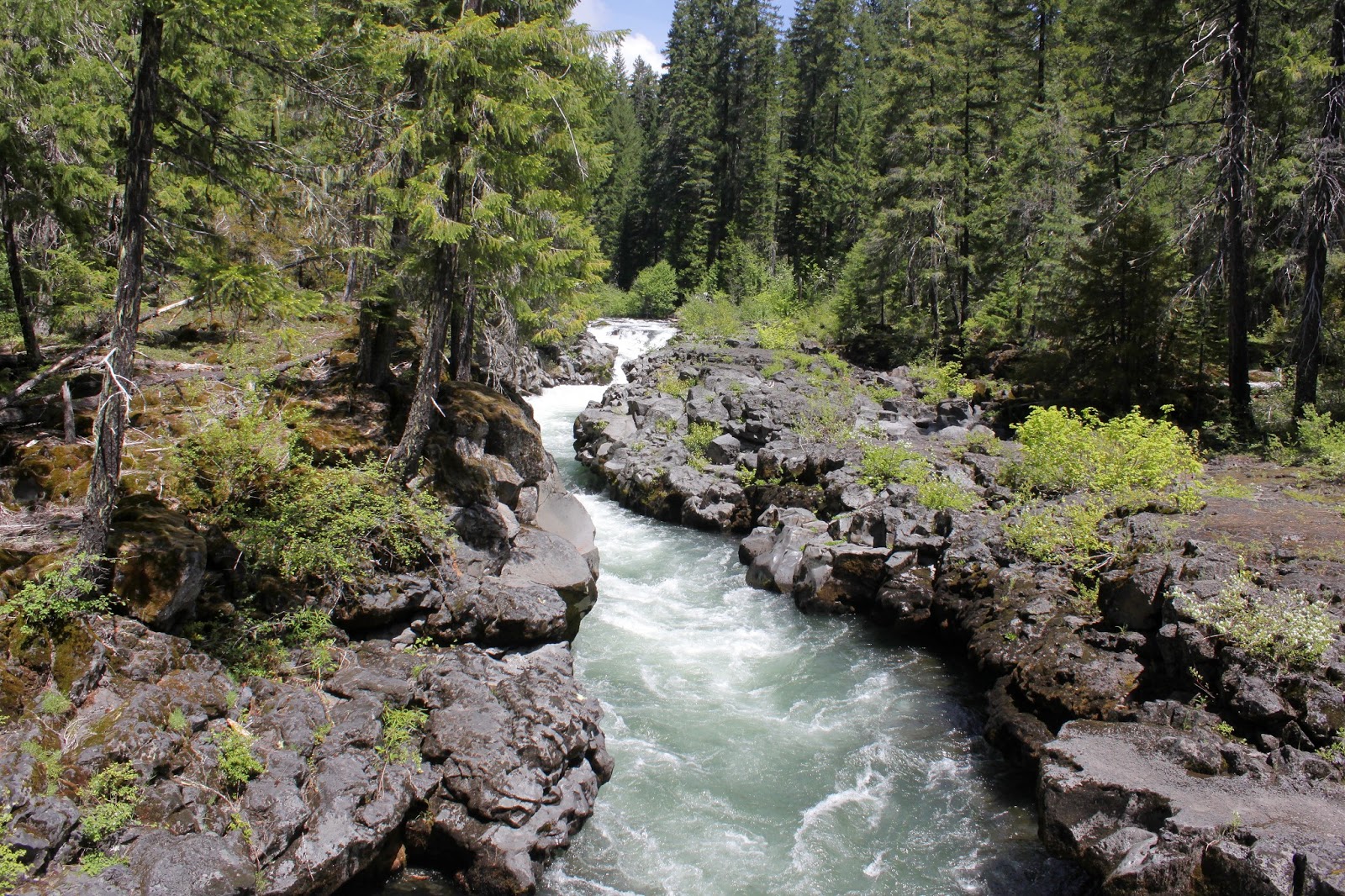
The Rogue River initially was on its best behavior, lazily coursing in tranquil and serene pools that reflected the green forest. Of course, that would change and a short uphill push took us to an overlook of Knob Falls where the Rogue became considerably rowdier. Basically more cascade than an actual waterfall, the Rogue seethes in a confined slot canyon as it tumbles 60 feet or so. A side trail drops hikers down a narrow ridge to a closer view of the action.

Note to self: Do not camp at a bottom of a cliff
Attaining the high ground overlooking the river, the path stayed high above the river. The trail was shady and pleasant but did provide occasional views to the river, now constrained to a narrow canyon with a massive lava cliff on the other side. Large rocks were in the river, delivered courtesy of the crumbling cliff.  

False Solomon seal
As mentioned before, spring was happening on the Upper Rogue and cameraholics spent a lot of time prone upon the trail, taking pictures of Oregon grape (all hail our state flower!), wild iris (my World of Warcraft user ID), creeping ceanothus (my Halloween costume), and the exotic looking calypso orchid (my stage name).  Pink and white spears of candystick were pushing up through the forest duff.  But really, this hike was all about the dogwood and vine maples.

Woof woof...it's a dogwood flower
Dogwood was blooming everywhere and I had ample opportunity to practice the craft of taking pictures of dogwood flowers against the blue sky.  The vine maples were leafing out and the very air seemed green underneath their leafy bowers draped over the trail.  As an aside, does anyone ever use the word "bower" besides long-dead poets and hiking bloggers? Anyway, it was definitely a green and white hike.


Quick, Rogue River, to the Bat Cave!
At about 3.5 miles our rugged little trail became paved. Paved? There's no paved in hiking! We had arrived at Natural Bridge, a popular (and paved) tourist spot on the Rogue. The bridge refers to a lava tube into which the entire Rogue River disappears only to surface a short ways further down the canyon. However, in spring when the river is full, the bridge is hidden beneath the river's flow. The whitewater is pretty impressive and entertaining nonetheless and is still worth a springtime visit.


Green trail
We continued on, leaving the hordes and the railed (Rails? There's no rails in hiking!) trails behind, returning to a bona fide dirt and rock path through rampant greenery.  After a lengthy lunch on a slab of bedrock next to the river rushing around an island, we continued onto the only uphill section on this hike.

Hi ho, hi ho, across the bridge we go
Climbing up a forested ridge and then descending back down, we renewed our acquaintance with the river. Here the river runs through a collapsed lava tube and is not very happy about that. However, the seething and roiling river was extremely scenic and we enjoyed several gawk-stops along the way before crossing the river on a footbridge.


Beautiful day in the Cascade Mountains

Now all we had to was walk the 5 miles back to the car alongside the river, flowers, and trees as the sunlight slanted in the late afternoon.  So, the weather report called for showers the next day too and and I anticipated piling into the car to enjoy another sun-soaked hike.  Turned out the showers that didn't shower on this hike were saved up for the next day as it just poured rain non-stop and once again, a hike was canceled.  Darn fickle weather gods!

Candystick
For more pictures of this hike, please visit the Flickr album.