Showing posts with label Hart Mountain hot springs. Show all posts

Tuesday, June 11, 2013

Barnhardi Basin

Ah, Hart Mountain Antelope Refuge is so beautiful. Wide open spaces that go on forever with enough tall mountains to keep little hikers with big egos relatively humble. Later in the year when the sun bakes the refuge hot and dry like a bachelor baking a pot roast for the first time, the refuge is probably not as hospitable as it was during our stay here. We hated to leave but leave we must so we saved the best hike for last: a pleasant stroll into the green dale of Barnhardi Basin.

Merle, at an early morning start to the hike
On the plus side, getting to the trailhead required no driving as the Barnhardi Road began at the hot springs in our campground. Not wanting to get pulled into a conversation with "The Naked Guy" frequenting the hot springs, we averted our eyes and walked quickly past. The trail, actually a jeep road, followed Rock Creek for a while before peeling away and heading uphill alongside a small fork of Rock Creek.  

Cold and cloudy Warner Peak
The skies were gray and overcast and a blustery wind kept things cool and perfect for hiking. The creek burbled merrily as a dense stand of white-barked aspen kept the stream hidden from view. Not so perfect, however, was the grade as the road climbed relentlessly up the sagebrush-covered slopes of Hart Mountain.  It's trails like these that get me muttering to myself "I need a new hobby" and "I hate hiking". However, the grade ended at a ridge crest with a nice view of cloud-bound Warner Mountain. It's trails like these that get me muttering "I'm glad I have this hobby" and "I love hiking".

Foolhardi 
Barnhardi Basin is a green meadow right below Warner Peak, and we splish-splashed through the wet grass to the Barnhardi Cabin. An old homestead cabin, the shack is pretty dilapidated with a sagging roof and floor. There are not enough Martha Stewart doilies in the world to make this ramshackle cabin a habitable home, even with the world class view from the front door.

Water in the desert
Well, we had reached our destination but had not walked yet very far and it was decision time. We could have returned cross country through the narrow cleft of Rock Creek or we could follow the Barnhardi Road and see what there was to see. We chose the up-and-down latter option. Amazingly for this area, a genuine bona fide creek crossed the trail and the vegetation was lush and verdant. So many flowers blooming by the wayside and I soon lagged behind, a camera-happy fool.

Buzz! Hah, scared you!
At the 4 mile mark, I turned around, content with a respectable 8 mile hike. John and Merle continued on and I enjoyed a leisurely return, taking pictures of all the desert flowers we never see on the west side of the Cascades. The terrain was abuzz with the love songs of the cicadas. The critters were flying all over the trail and if hikers stepped too close, they buzzed a warning like a rattlesnake would. I was a nervous wreck by the time the hike ended.

Pellet pusher
At one point, I was looking at a pile of deer poop when a pooplet or pellet or whatever you call an individual piece of the pile began rolling around seemingly possessed by a poo-poo poltergeist. Upon closer inspection, there was no supernatural explanation needed, it was simply a handstanding dung beetle rolling his treasure with his back legs. I'd never seen one before and now I'll have to give extra scrutiny to deer poop piles. And, I wonder why I have no friends.

Aaaaah....
At the bottom of the trail, there was a primitive hot springs that burped sulphurous gas bubbles (just like my brother) in the clear water. I removed my shoes and soaked my feet in the hot water, as happy as a purring cat. We definitely saved the best for the last!

Bye, Hart Mountain
For more pictures of this hike, please visit the Flickr album.


Sunday, June 9, 2013

Poker Jim Ridge and Petroglyph Lake

After a cool first night at Hart Mountain Antelope Refuge, we slapped at mosquitoes the following morning as we prepared to go hiking. On the skyline of Adams Butte, I could make out the silhouette of a pronghorn antelope sprinting up the butte's slope. Now, there's something you don't see on the west side of the Cascade Mountains!

Flat is as flat does
The hike along Poker Jim Ridge is a cross country walk through the sagebrush and the going was not particularly speedy as the rocky ground made for tedious walking. Since there were no trees, navigation was simple: keep the ridge rim within sight on the left side and don't step off, the next stop would be 3,000 feet below!

A snake with anger management issues
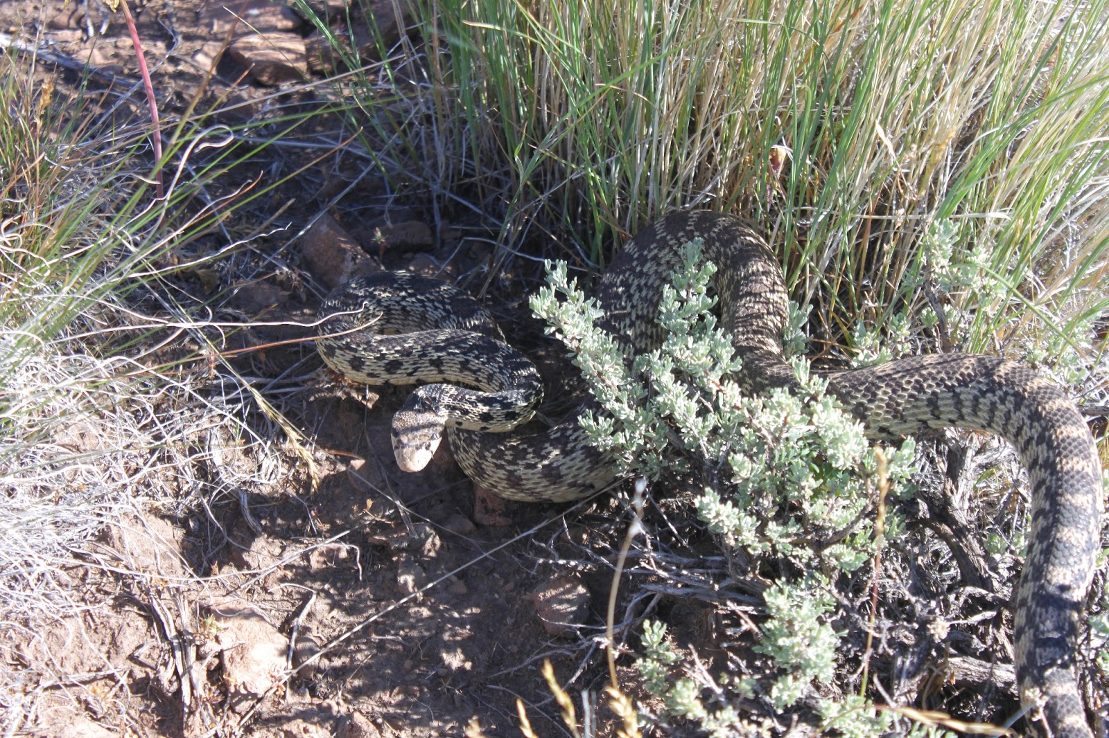
At the start of the hike, John found a large gopher snake that was not too happy to see us. Coiled up in a defensive posture, the snake hissed and vibrated his tail, it wanted us to think it was a rattler. After taking a few pictures of the snake, I moved the toe of my boot into its personal space and my boot was subsequently attacked. Despite knowing the snake was harmless, I still jumped.

No Dollie, I would never drive your car on that road
From Poker Jim Ridge, the views were tremendous. Directly below was Campbell Lake and its other Warner Valley lake friends:  Lakes Flagstaff, Upper Campbell, Stone Corral, and Turpin. Bluejoint Lake, the northernmost  lake, was all dried up but we could see where it had been. Further south were Hart Lake and the small itty-bitty town of Plush, both flanked by the rock wall that is Hart Mountain. Beyond the Warner Valley were the desert mountains, most of them brownish in color.  Truly a vista for the ages.

Petroglyph Lake in the distance
We worked our way up to a small high point on the ridge and enjoyed lunch in shade provided by a copse of juniper trees. We could see for miles and miles and two small lakes glistened in the vast expanse of the refuge, one of which would be our next destination.

John sets sail to the lake


We dropped off our knoll and headed overland to Petroglyph Lake which disappeared from view like a mirage as we lost elevation. Not to worry, though, we kept going in the same direction and eventually happened upon the lake, hidden in a natural bowl in all the sagebrush.

Colorful Petroglyph Lake and don't drink the water
Surprisingly, there was a lot of color at Petroglyph Lake, seeing how it was ringed by tansy-leaved evening primrose which was blooming bright yellow in broad daylight, despite its name. Green grass ringed the lake and reeds hugged the shoreline in the milky waters of the lake. Petroglyph Lake, as is the case with so many of the lakes in this area, has no outlet so the waters tend towards the muddy and alkaline.

Petroglyph
At one end of the lake, there was a rocky cliff and we explored the cliff, taking in the petroglyphs that give the lake its name. I tried to be respectful but one of the glyphs sure looked a lot like Sponge Bob. We wondered if the glyphs were art, storytelling, advertisements, or graffiti. I supposed it might have been the equivalent of what you see in our public restrooms: "For a good time, send smoke signal to Running Turtle" or "Here I sit all broken-hearted, tried to poop but only rock-arted".

Merle and Richard try to keep pace with John
At any rate, we left the lake and headed across the flat sagebrush plain to our car. Apparently there was a pronghorn baby hidden in the sagebrush that took off running in panic at our arrival. Pronghorn can run at speeds up 60 mph and it was impressive to see the little guy speed across the same rocky plain we were struggling to walk through. We also got to see a mother with two pups(?) in tow, eventually joined by enough other pronghorns to formally constitute a herd.

Fading light on Hart Mountain
So back to camp we went for a post-hike soak in the hot springs. We did learn to avoid "The Naked Guy" after this particular evening soak. After the rustic Jacuzzi, we were treated to a superb sunset and the end to a productive day.

Spectacular sunset
For more pictures of this hike, stop by and visit the Flickr album.


Saturday, June 8, 2013

Hart Mountain

Hart Mountain National Antelope Refuge is only about 190 miles from Roseburg as the crow flies.  However, it took us all day to get there as Hart Mountain is not an easy place to get to, being situated in the middle of the Oregon outback with its wide open spaces and a notable paucity of roads, paved or unpaved. After a full day's 400 mile drive, we (John, Merle, and your intrepid blogster) arrived at the Warner Valley and Hart Mountain itself.

The reason for the refuge
By this time, we had left any semblance of forest well behind us and entered an arid world of sagebrush and wide sweeping vistas of bare mountains and vast valleys in between. Shortly before arriving at the handful of buildings and homes that comprise the hamlet of Plush, we actually espied a lone pronghorn antelope eyeing us disinterestedly as we drove by. Safe to say, we were not in Roseburg anymore.

Hart Mountain rises from the Warner Valley
Many epochs ago, seismic processes uplifted a block of the earth's crust and the net result is that the massive wall on the west side of Hart Mountain was pushed up an intimidating 3,000 feet above us as we drove on the dirt road hugging the mountain's base. The mountain flanked the Warner Valley and even though we clearly were in the arid desert, the valley floor contained a series of large lakes and marshes known collectively as the Warner Lakes. Small creeks tumbling seasonally down the mountain's face had carved deep and incredibly rugged canyons over time. The slow pace required by the rough road allowed us to soak in the views in typical tourist mouth-agape fashion.

Some of the Warner Lakes
Things got way cool when the road peeled away from Campbell Lake and proceeded to climb away from the valley and lakes. The Warner Valley wetlands lay at our figurative feet with view of lake after lake with the barren Coyote Hills chasing the equally barren Rabbit Hills in perpetuity on the other side of the valley. The road inched up the Hart Mountain wall and we must have looked like a tick climbing up a pant leg to anyone looking down.

We set up camp and the mosquitoes are happy
We set up camp at the primitive Hot Springs Campground. Despite the primitive part, the camp was one of the better camps I've camped at. Little Rock Creek trickled through a relatively green valley flanked by willows with expansive views of the sagebrushed hills and snow-patched Warner Peak. We set up camp in the trees where we were isolated from the semi-constant wind. Unfortunately, there was no isolating us from the mosquitoes lurking along the creek. And best of all, there was a genuine bona fide hot spring that became a regular post-hike destination during our stay.

Awww...isn't he cute?

For more photos of our first day at Hart Mountain, please visit the Flickr album.