

While I was researching trails the other day, I ran across a hiking difficulty calculator that dispassionately rated the difficulty of any given hike based solely on empirical data, something that always will seduce my geeky mathematician's heart. Basically, the operative formula is the square root of twice the product of distance in miles and cumulative elevation gained. The number obtained is then matched up to a scale for the rating. There'll be a pop quiz in the morning, kids.
 |
| John's army |
The destination of choice this day was the North Bank Habitat and surely the steep hills and trails of the habitat would provide some interesting fodder for the arithmetic machinations described above. It'd be interesting to take into account other factors such as weather, trail quality, mosquitoes, and bad puns from those hikers so predisposed. Not that things were particularly dire on the day of our North Bank hike, for the weather was merely chilly and just perfect for hiking in, provided the potential rain remained in abeyance.
 |
| Oak trees, yup, lots of oak trees |
Our little gang of five enjoyed an easy warm-up walk for the first mile or so. The route was initially on a level working ranch road before peeling off onto an equally level hiking-only trail along the wooded Chasm Creek bottomland. The track there was surrounded by thick stands of oak and madrone, the oak trees being bare of leaves this time of year, but well-bedecked with copious strands of Mesuthelah's beard and other lichen drapery. In the madrone groves, a virtual tabernacle choir of songbirds were chattering and nattering among the leafy trees, nearly drowning out the chattering and nattering of some hikers in our party.
 |
| If it's in the North Bank, then it's steep |
Heh, heh, the nice level trail was too good to last, seeing as how this is the North Bank we are hiking in. The angle of the trail gradually began inclining steeper and steeper, stopping seemingly somewhere at just marginally less than full vertical, but only just. My new lighter and improved physique felt more like my heavier and unimproved former self in direct proportion to the increasing grade.
 |
| Our "reward" for going downhill looms above us |
After what felt like an endless death march up through the oaks and grassy slopes of the "gentle" and rolling hills of the Habitat, the North Boundary Ridge was finally reached. None of us overtly celebrated though, as we were all aware that the trail would go up and down in steep fashion along the ridge for the next mile or two and there'd be no respite for weary legs until the hike was pretty much over. There's probably like 10 separate uphill pitches on this section that felt more like 1,183.
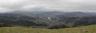 |
| A vista like this makes the hard work worth it |
Photo stops are the last refuge of tired hikers and I availed myself of the many opportunities on the up and down ridge. The terrain dropped off at our feet, bottoming out in the nascent valleys of Jackson and Chasm Creeks. The area was surrounded by ridges and lesser peaks, most covered by a dark fuzzy blanket of woods and forest. On the valley floor, the North Umpqua River glinted silver in what little light managed to seep past the heavy cloud cover. The scenery is spectacular on any day but the foreboding weather added a touch of gloomy drama, further enhancing the panorama from the top.
 |
| A brief wooded interlude on Middle Ridge |
Middle Ridge was our route back down to the trailhead and since this is the North Bank, there were still several steep uphill pitches to contend with, even though we were heading downhill in general. We were all appropriately tired from the hilly exertion so we stopped at a picnic table sited under some madrones for a well-deserved lunch break.
 |
| Epic view down to the Whistler's Bend area on the North Umpqua River |
After lollygagging for a bit on the Middle Ridge rest and repast session, we continued with our descent down Middle Ridge. The terrain was generally grassy and treeless, and we continued to enjoy the ever enfolding view as we lost elevation. Cold air was wafting up from the valleys as the temperature dropped, seemingly in concert with the drop in elevation. Precipitation somewhere between a hard drizzle and actual rain splashed both trail and hikers for a few minutes but the sun eventually made a weak appearance at the trailhead. And speaking of weak appearances, I also eventually showed up at the trailhead.
 |
| Scratchy |
It was somewhat disappointing that the hiking difficulty calculator rated this hike as "moderately strenuous". Even though my admittedly biased and highly subjective hike rating was more like "super-duper strenuously hugely strenuous" you really can't argue with the numbers. As a comparison or point of reference, the empiric calculator had likewise rated my recent hike at Jacksonville Forest Park as "moderately strenuous". But applying the O'Neill methodology, which basically consists of me asking my legs for their opinion, said this North Bank hike was far tougher than what the Jacksonville hike had ever served up. That leaves me where I started from, calculator-wise, in that the difficulty of a hike is still a highly subjective determination based on not just grade and miles, but on the conditioning and overall whineability of the hiker making the determination. My geeky mathematician's heart remains unrequited.
 |
| My downhill form |
For more photos of this hike, please visit the Flickr album.
No comments :
Post a Comment