Showing posts with label coquille river lighthouse. Show all posts

Saturday, December 5, 2020

Coquille River


Didn't see that coming! At the end of my hike in the Bullards Beach State Park area, there was parked a van covered with all kinds of decals for windsurfing gear and paraphernalia. The striking combo of white van and dramatic background of dark and foreboding clouds triggered my inner photographer. The rear doors of the van were open so I casually approached the vehicle with the benign intent of politely asking the occupant for permission to take a photo. Yikes! The van was solely occupied by a pair of rabid dogs (wolfhounds from Hades, even!) that let me know vociferously and with much rabidity that my presence anywhere near the vehicle was most definitely not canine approved. I staggered backward in surprise and shock, but really, that was just the last travail on a hike that did present several other trials and tribulations. Also, it was the only travail that involved snarling and sharp teeth but then again, I wasn't hiking with my wife.

The lighthouse presides over the mouth of the Coauille River

There is no official trail along the Coquille River but one can follow a series of use paths tamped out by curious rivergoers or simply follow the wide river when the paths peter out. After shooting some photos of historical Coquille River Lighthouse, I began walking upstream on the aforementioned paths. The sun was out and the river sparkled in the morning light while the town of Bandon sprawled peaceful and quiet on the other side of the river.

Remnants of a bygone era

Bandon's been around since the 1850's or so and much of its history is that of port and harbor on the Coquille River. Once the lighthouse environs were hiked away from, I observed vestiges of that former history in the form of pilings and wooden pillars where once stood viable piers, wharves, and maybe a crab shack of ill repute or two. Notably, the tide was visibly surging upstream through the decaying pilings. Good thing I'd be well off the river banks by the time the tide actually crested.

Raccoons patrol the sandy banks of the Coquille

For the most part, hiking along the river was fairly easy. The tide was rising but not yet fully risen, the ground was firm, and the weather bright and sunny. And yes, you guessed it, that was all too good to last. Bad weather was in the afternoon forecast and by mid-morning, a dark cloud bank scudded over and that was it for the nice sunny day. Additionally, the hiking became a bit tedious when a water-filled slough entered the river at right angles to my route. Time for some bushwhacking!

One of a whole slew of sloughs

It was just a little slough, yet it was too wide to jump over and too deep to wade across, so I followed its banks inland until the watery channel petered out. Part of following the channel involved beating my way through dense patches of Scotch broom, scratchy low-growing conifers, and thorny bushes of gorse. Eventually a pile of logs provided the means of getting across the channel and I made my way back to the river, which acted like nothing out of the ordinary had ever happened at all.

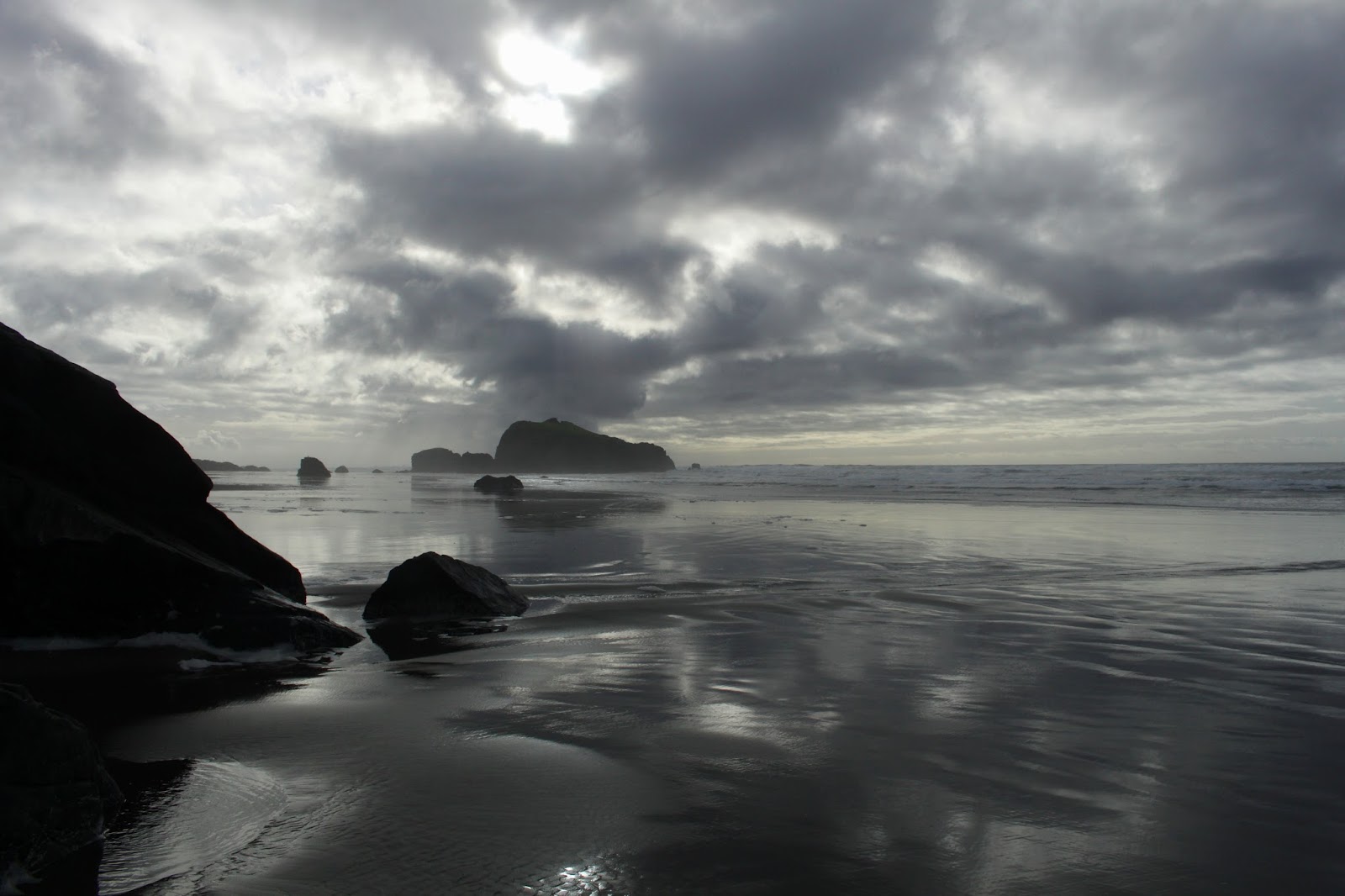
"Make speed in the gathering storm..."
(Paul Kelly)

That was just the beginning. The sloughs came with increasing frequency with each one being wider and deeper which was really annoying because ahead, I could clearly see Bullards Beach Campground, my intended destination. The campground was less than a mile away but it might as well have been located on Jupiter's twelfth moon, thanks to the intervening sloughs. As I negotiated my way around each water channel, the daylight dimmed considerably thanks to increasingly dramatic clouds emoting over the coast. The wind picked up and obviously, rain would be happening at some point in the afternoon.

A waterfowl flees the scary hiker
trying to cross the water channel

What was also increasingly obvious was that the water channels would not let me get to the campground via the Coquille River. The largest slough yet pushed me well to the west and nearly all the way to the beach foredunes, which was almost where I had started this hike from. Giving up on the river-walk thing in entirety, I veered north through some scrubby hinterlands, eventually crossing the Bullards Beach roadway. From there, I grabbed the paved trail leading to the campground, the path providing nice overlooks of the wide river. However, the weather was trending toward downright belligerence, so it was deemed prudent to start heading back to the lighthouse before things got too miserable.

The wind moves sand at high velocity

After taking a sandy footpath that led to the beach, I commenced hiking south into the wind. Airborne rivers of fine particulate matter flowed just a few inches above the sand and my booted and pantsed (panted?) ankles and shins didn't care. My pace was not all that quick because the foreboding clouds were wildly photogenic in a moody and stormy way; naturally, lots of photography ensued. High tide was surging and I had to run from waves every now and then. The constant wind and surf churned up small clouds of seafoam that were spirited away by the breeze to points unknown. Hiking on the beach in stormy weather is wild, yet totally exhilarating, and I enjoyed every tempestuous minute of it. 

This van guarded by devil dogs


After an adrenaline-fueled backpedal away from that van full of snarls and growls, I heard a chuckle from in back of me. It was the wetsuited owner of the van and devil dogs, quite amused by my discomfiture. But, he did let me take my photo and that capped off a great hike and photography combo.

A storm cometh. It has been foretold.

For more photos of this hike, please visit the Flickr album. 

Friday, December 1, 2017

Bandon Beach


Every year, around this time, rainy weather comes to southern Oregon, ready to hang out for the next 19 months, or at least it feels like 19 months. In the higher elevations and mountains, the rain translates to snow, making it time to search for lower elevation hikes with snow-free trails. Well, you can't get any lower than the beach, so consequently my winter itinerary is heavily weighted towards coastal hikes.


Foam, foam, foam on the range....
Because I've spent a lot of miles on beaches in less than optimal weather, I've entertained many an opportunity to execute a life-saving sprint across the sands with a sneaker wave lapping at my heels. And, after being truly invested in the outcome of the wave vs. human contest, I've learned that prudence dictates a) knowing what the weather forecast foretells, and b) consulting a tide table and generally avoiding high tides.

Postcard moment on the beach
High tide at Bandon Beach was at noon, give or take a few minutes. Accordingly, Luna and I lollygagged at home before heading out to Bandon later than normal, timing the drive for arrival pretty much at the crest of high tide. When we showed up at the Coquille River jetty, waves were marching up the river channel in intimidating fashion and no boats were trying to exit Bandon Harbor. The beach between the jetty and the rocky islands of Coquille Point was awash with waves rolling up into the driftwood below the dunes. But it was a receding tide and would only get better so we set out, braving the mild inconvenience of having to hike in driftwood and run from waves. For some reason, there were no other beachgoers out and about, we had the entire beach strand to ourselves.

High surf pummels an island
Because the tide was still high, walking around the front of Coquille Point wasn't going to happen, so we scrambled over some rocks at the neck of the point. Our reward was the fantastic scenery waiting for us on the other side. Bandon Beach proper curved away from us, culminating in Gravel Point. The bay was filled with roiling white surf peppered with rocky islands and sea stacks. Driftwood covered most of the inland part of the beach, and the clouds were spectacular, allowing just enough sun to leak through, causing the sea to shimmer with a silvery light. Of course, all Luna saw was her people walking their humans, too; she whimpered wistfully, longing to socialize with her kind.

It was a marvelously gloomy view to the south
The pace of our hike slowed noticeably here, as much photography abounded. So many pointy rocks to take pictures of, each affixed with a lordly seagull on top. The tide was noticeably receding by now, so we had enough beach to walk comfortably on. I wasn't sure of it had receded enough to let us walk past Gravel Point but no worries, there was just enough sand to get by with some judicious timing of the waves. Luna was in her element as we sprinted around the point before the next wave came in. She is just a little bit faster than me. More graceful, too.

Rock islands and a silver sea
As we continued to hike along the beach, civilization gradually receded behind us. Accordingly, Luna was set free and she sprinted all over the beach. There were seagulls to chase, creeks to splash in, and an entire ocean readily available for a frolic and caper. We should all hike like Luna. Me, I mostly took photographs of the spectacular cloud bank straight ahead to the south.

A cloud floats above the beach


In back of us, the sky was blue but straight ahead, it was all doom and gloom. The clouds were dark and foreboding, portentous even. Tendrils of black rain hung from underneath and the sun poked holes in the dark tapestry here and there. A storm was in the forecast but apparently it was sweeping in a northeastern direction and pretty much left us alone.


Luna, in her element


Haystack Rock was the last island big enough to have a name and we continued on past until there were no more rocks or islands at all. Just miles and miles of soft sand stretching all the way to Port Orford, if one was inclined to walk 27 more miles in soft sand. Crooked Creek made for a logical turnaround point, although we had to allow for some quality dog-splash time in the creek.

A sneaker wave comes in to make me run
On the way back, it was nothing but blue sky ahead, apparently we were hiking underneath the intersection of blue sky and black clouds. The tide had retreated, leaving us acres of wet sand to hike on while fluffy sea foam marched across the wet strand, propelled by a coastal breeze. A small wave rolled in, catching the light just perfectly, and I stopped to capture the scene. Click, click, the camera was doing its thing when I realized the wave was not going to stop for a while. Darn sneaker wave, even though it was low tide! Normally, you sort of casually jog from the larger waves but not this one, I was running at a full dead-on sprint with the wave literally splashing at my heels. The sprint lasted nearly 100 yards and let's just say that I'm no threat to Usain Bolt as I lumbered across the wet sand like an obsolete Imperial Walker from the very first Star Wars movie. Luna thought it was great fun though, leaping and snapping at her leash, deliriously happy to be running with her lord and master while being totally unclear on the concept of running to safety. For the remainder of the hike, we kept a more respectful distance from the surf.

Looks irritated with my photo-taking
The remainder of the hike was more uneventful as the weather improved over the miles. Good thing too, I'm not sure how many more such sprints I had left in the tank. There was now a healthy population of fair-weather beachgoers out and about, including a group that creates artistic labyrinths on the the sandy beach canvas. They invited us to play in the nascent maze but we still had several miles to go. By the time we reached the Coquille River, the setting sun imparted a soft golden glow to everything. It was a perfect end to a great day on the Oregon coast.

Perfect ending
For more photographs of this hike, please visit the Flickr album.


Sunday, July 13, 2014

Bandon Beach

It's hot. Very hot. So very hot. I'm melting like a spit out piece of used bubble gum on a hot sidewalk. Ants will die in my gooey puddle and passerbys will wonder what was that sticky stuff they stepped in as they scrape their shoes clean on the concrete curb baking in the oppressive heat. I can only open the freezer door and stick my head in the ice bucket, dreaming of a world where life is wonderfully cooler...like Bandon!

How to beat the heat
So, while the Umpqua Valley stands in front of the heater vent of the universe, Bandon (and the Oregon coast, in general) enjoys perfect weather: overcast, some rain, and temperatures topping out at 60 degrees. I'm as jealous as my dog watching me pet the cat. Just to clarify, I only actually pet the cat when Dollie is watching or just to annoy the dog. But anyway, I was glad to park the car next to the Coquille River in Bandon on a delightfully cool morning where clouds were wonderfully gray, water occasionally fell from the sky, and a cool breeze caused me to don a light jacket.

One lone seal causes a stir
The beach was fairly busy next to the river jetty and I couldn't help but suspect all the beachgoers were Roseburg heat refugees like myself. The beach sand was soft as I walked past the numerous rock islands that make hiking on Bandon Beach so special. The map says I hiked past Black Rock but they all looked black to me. Further up the beach, a small crowd gathered excitedly in front of an island close to the shore. The cause of all the hubbub was a lone seal sitting on a rock. Well, to be technical seals don't sit, it was propped up on its flippers in sealy repose, fully entertaining the easily entertained masses.

Crop circle, beach style
The beach seemingly ends in a rock wall at Coquille Point, but the wall is really a collection of individual  islands, rocks, and stacks and there is a path through the maze. On the other side of the point was a bay with a beach adorned by crop circles, sans crops, of course. A man with a stick was creating the impermanent works of art and children big and small were walking in the mazes inscribed in the circles. It sure was embarrassing when I couldn't find my way out!

Face Rock
Just opposite Grave or Gravel Point (it depends which map is consulted, I've seen both names used) is an island known as Face Rock. Legend has it (this is the short version) an angered sea god froze the Princess Ewauna who had entered the sea carrying a cat and kittens in a basket. As a reluctant cat owner, all I can say is "r-i-i-i-i-i-ight..." about the idea of successfully carrying a cat, much less one with kittens, in a basket into the ocean. At any rate the angry sea god tossed all the mewling felines into the ocean and froze the the princess. My feeling is that the cats probably were to blame for the whole incident somehow. The princess is now Face Rock, forever gazing up at the moon. A nearby collection of islands lined up in a row are now collectively known as the Cat and Kittens. I do find the idea of cats permanently soaking in the wet surf quite amusing. As an aside, the princess entered the sea with her dog but the dog managed to avoid being turned to stone, thereby proving dogs are smarter than cats, kittens, and princesses.

Four-legged tourists
This is not your basic wilderness hike what with inns, hotels, and luxury homes perched atop the cliffs and in some cases, halfway down the cliffs. The beach here is a tourist attraction and there were many tourists out enjoying the scenic beach. Several creeks crossed the beach and the warm waters were steaming in the cooler air. A posse of horseback riders passed by and there was more stuff steaming on the beach, if you get my meaning.


It's steamy in the Oregon tropics
At Devil's Kitchen, which incidentally could be an alternate name for Roseburg right now, the houses petered out and the wild beach began. The 15 mile stretch of beach from Bandon to Port Orford is undeveloped and is Oregon's longest stretch of wild beach. Fellow hikers were few and far between after I passed Haystack Rock, the last island on Bandon Beach.


Find the snowy plover in this picture
As wild as the beach is, a rope fence keeps hikers off of the dry sand. This is snowy plover territory and the small bird is endangered. The plover spends it's entire life on the sand and it is easy for hikers to step on camouflaged eggs and chicks. In Oregon, the protection offered the plover is nothing new for me but for the very first time I observed a plover sprinting ghostlike across the sand. All I can say, is the birds are well camouflaged on the light colored sand.

Get the flock out!
Periodically, flocks of sanderlings flew by like airborne schools of fish, all turning in the same direction at the same time. If I was a sanderling, I'd be the one turning left when all turned right, causing a spectacular mid-air high speed pileup. I'd also probably get excommunicated from the flock at some point, too. There were also a number of vultures on the beach, just watching me...just watching...they made me nervous. 

As good as new
At just under 6 miles, the New River hove into the view. The map says the New River mouth was about 6 more miles ahead of me so if the large river running in front of me was not the New, then it was good as New. Sorry, I can't help it. The New was running wide and deep and like me, was not going to be crossed today. Besides which, I still had a 5.5 mile hike to get back to the car at this point.

An oystercatcher sneaks away
A nice little lunch 'n laze was enjoyed at the river's edge, the time spent observing the chaotic clash of watery titans where the New River collides with the Old Ocean. But all New things come to an end and back I went for the long walk to the car. I got to observe the gulls and sanderlings again while the vultures disconcertingly observed me like hungry patrons watching an approaching waiter bring their meal.


Why I hike on Bandon Beach
It was pleasantly cool and overcast on the drive home until I reached Camas Valley. There, the clouds dissipated and the sun was a big ball of way too hot fire. Normally, it's good to be back home but not when you're a figurative chestnut roasting on an open fire.

This hike rocks!
For more pictures of this coastal escape, please visit the Flickr album.