Saturday, May 18, 2013

Brookings and Gold Beach road trip

This was a weekend of diminishing expectations. Originally, the plan was for Dollie and I to do a weekend backpack trip. However, in order to keep things relatively happy and calm in the O'Neill household, the destination was moved from the Siskiyous to the Oregon coast. When the weekend weather was prognosticated to be wet, the backpack trip morphed into a dayhiking weekend with a motel involved. When my hip popped while executing the dangerous and tricky getting-out-of-the-car maneuver, the trip became a road trip unless I wanted to hike with a walker.


Add a few throw rugs and call it a home
We began Saturday morning by hobbling through Azalea Park in Brookings. Well, to be honest, Dollie spryly walked while I gimped, dragging my right leg behind me. We were a week early for the Azalea Festival but we could nonetheless enjoy the tree-sized azaleas blooming in the park's manicured grounds. The rhododendrons were putting on a show with a veritable floral rainbow as rhodies of every color bloomed alongside the colorful garden paths.


Dollie considers going for a swim
After our park walk, we headed over to the coast proper, stopping first at Harris Beach. After a brief overlook it was time to head into the beautiful Samuel Boardman State Park. The Boardman park is one of the most scenic and hiker friendly stretches of the Oregon cast and we stopped at Lone Ranch Beach, Cape Ferrelo, and Whalehead Beach. It seemed like I was walking my way out of whatever injury I had accrued so we actually took a short walk on the Oregon Coast Trail on the grassy slopes of Cape Ferrelo. Dollie provided some amusement crossing Lone Ranch Creek on some slick logs but managed to avoid an early spring swim. 

Bowl, at Indian Caves
Feeling "walky" by now, the short hike to Indian Sands was in order. A brief descent through a coastal forest on a trail covered with slugs and mating centipedes brought us onto the sands. The dunes are kind of oddly located, being perched high atop a rocky cliff. The ocean pours into an incredibly scenic rocky bowl replete with waterfall and a rock arch. Wild iris was blooming everywhere, augmented by scarlet Indian paintbrush, white wild strawberry, and purple lupines.

Ah-choo!
Returning to our rustic cabin room, the last little item on the day was a pre-dinner walk along what I presume is Gold Beach's Gold Beach. The clouds were dark and moody (no sunset on this evening) as the wind gusted, messing up what little hair I have. Lupines and beach peas were blooming away in the dunes but the Scotch broom was the invasive star of the show. Brought to our shores by those darn Scottish settlers from days of yore, the plant has made a happy home for itself in the New Country. Incredibly invasive, the broom crowds out native plants and is not welcome (Curse you, McBroom!). Despite the pernicious aspects of the shrub, the bright yellow flower masses are quite spectacular, unless you are hay-fever afflicted like my wife.

Yup...
So, despite the lowering of standards for the weekend, we covered quite a bit of ground and managed to get some hiking in...and I didn't even need a walker! 

Visit the Flickr album for more pictures of this wonderful little corner of the Oregon sandbox.
Gold Beach at twilight


Saturday, May 11, 2013

Grizzly Peak

It seems to me that Grizzly Peak should be to all the other Bear Peaks in Oregon what grizzly bears are to a run-of-the-mill ordinary black bear. In ursine terms, a 5.4 mile hike somehow seems to be more of a koala bear of a hike. However, hiking buddy Glenn assured me the hike was worthy and since I'd never been, Saturday morning found me driving down to Ashland.

Oregon anemone
After a pleasant drive through purple stained hills (the deer vetch was in spectacular bloom) dotted with newly leafed out oaks, I was joined at the trailhead (which had a great view of Mount McLaughlin, by the way) by Glenn, Carol (Mrs. Glenn), and Karen (Glenn's sister). And with a fierce grizzly-like "Grrr..." we set off on the trail.

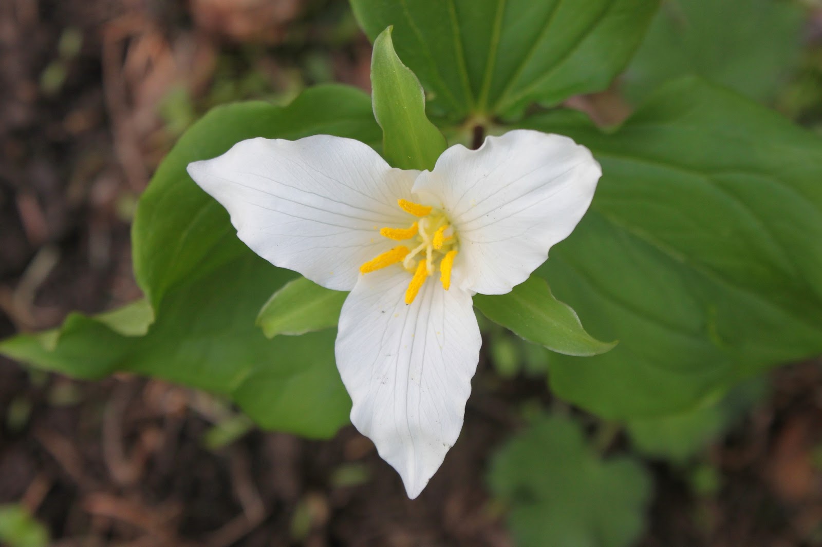
It was a trillium show in the forest
The trail wasted no time angling uphill through a shady fir forest, the quiet of the forest getting interrupted by the heavy breathing of a certain panting hiker from Roseburg. The undergrowth vegetation was still tamped flat by the recently departed snow but the trilliums and snow queen were sending up their early spring blossoms. The heart shaped and fragrant leaves of wild ginger were also spotted but a cursory examination under the leaves revealed none of the brown and hairy flowers.

See the blackfly?  I didn't, either!
Periodically, the trail would break out into open meadows with yet a few snow patches in them. The whole vibe reminded me of the Rogue-Umpqua Divide Wilderness.  Spring was in the air, literally, and each leg was bitten in turn by a welt-raising blackfly which started me yearning for the insect-killing cold of winter. I imagine mosquitoes and hikers will be renewing bloody acquaintanceship before long.

Disco lives!
After an uphill mile or so, we reached the intersection with the loop trail and opted to hike the loop counterclockwise. The trail leveled out and an unassuming  rocky knoll  flanked by thick patches of diminutive glacier lilies marked the official Grizzly Peak summit. Because of the dense fir forest, there were no views to be had but Glenn and I stood on the summit just because.

Smoky view to Medford
Intermittent views were enjoyed while the trail contours the edge of the broad summit; Mount Thielsen, Union Peak, and the Crater Lake rim were all spotted in the smoky haze. Views were somewhat limited due to hazy smoke, presumably from prescribed maintenance burns nearby.  The fires of the non-prescribed variety are coming because this has been a hot and dry spring.

Walking through the ex-forest
In 2002, the East Antelope Fire charbroiled the forest on the west side of of the mountain.  West antelopes were relieved and hikers have since been grateful for the fire really opened up the views by removing all that annoying forest.   The trail hugs the peak's rim under some rock formations with blooming wildflowers.  But mostly, it's all about the views, even on a hazy day.

Emigrant Lake, below Pilot Rock


Ashland lay nestled in a valley virtually 4000 feet below as the slopes dropped precipitously away from our mountain perch.  Rising on the other side of the valley were the snowy Siskiyou Mountains stretching from Mount Ashland to Grayback Mountain.  To the south was ghostly and very tall Mount Shasta with Emigrant Lake reposing below Pilot Rock.  To the east were the peaks marking the caldera of the Mountain Lakes, one of my favorite haunts.

Mission bells, they toll for thee
When not oohing and aahing at the clifftop panorama, we spent some time on our knees and bellies taking pictures of the many wildflowers blooming in the rock gardens.  Notable were coastal delphinium (a low growing larkspur), Hall's desert parsley, Indian paintbrush, and dwarf hesperochiron which incidentally used to be my nickname on the dude ranch...and that's all I'm saying about that!

All good things come to an end, including hikes, and we closed the loop and reentered the forest.  But, hey, at least it was downhill to the car.  So, while this hike logged an un-grizzlylike 5.4 miles, because of the great scenery, I rate this trail at four Tibetan blue bear paws.


For more pictures of this hike, please visit the Flickr album.

Saturday, May 4, 2013

Three Sisters Loop

This last weekend, I hiked the Three Sisters Loop. That phrase just rolls off the tongue in robust braggadocio with a just hint of studied nonchalance. But no, the hike was not the formidable 75 mile loop (surely covered with snow, this time of year) around Oregon's massive Three Sisters near Bend. Nope, these three sisters are a set of fairly nondescript cinder cones in the desert badlands of Lava Beds National Monument, just barely on the California side of the Oregon-California border.

I learned the desert can get hot
For some reason, desert hiking had been calling me so Friday I hopped in the car after work and drove the 4 1/2 hours to the monument. Arriving at the tail end of a spectacular sunset, camp was quickly set up in the fading light. It had been fairly warm but the temperature quickly dropped into the mid-40's. The temperature in the desert can rapidly change from hot to cold for no apparent reason, just like a teenager's mood swings.

Schonchin Butte, from the Bunchgrass Trail
Starting out in the early morning, the day was sort of sunny as puffy white clouds provided intermittent shade. A chill wind blew, though, and the cool temperature was just perfect for hiking. The Three Sisters Loop began from the campground on the Bunchgrass Trail which angled along the base of Crescent Butte, yet another small cinder cone.  There were so many cones dotting the landscape, it was as if the earth had goosebumps.

Dwarf monkeyflowers
I'm not sure if it was spring in the desert or not, or if there is even such a thing as spring in the desert, but thick mats of phlox were blooming in the rocks and volcanic ash. I saw some specimens of blazing star, cinquefoil, currant, and dwarf monkeyflower. That was it for the flower "show" as the unblooming sagebrush was the dominant life form on the Lava Beds planet.


To the Bat Cave, Richard!


At the foot of Crescent Butte, a right turn was made onto the Missing Link trail and somehow that was fitting. A mile later through the treeless sagebrush, the trail ended on the Skull Cave (also fitting, for some reason) Road, requiring a short road walk to the cave parking lot. I didn't have caving equipment so I just walked to the entrance and peered into the inky blackness of the cave tunnel.  Inside, it was dark and cold like yesterday's coffee in the mug on my desk. Actually, the coffee is probably older than yesterday to judge by the rafts of gray mold floating on top.  

Hungry for hikers
Caves are a large part of the Lava Beds experience and as I continued on the trail (now called the Lyons Road) all manner of sinkholes, deep cracks, and cave entrances proliferated right and left of the trail. The caves are caused by collapsed lava tubes and I began to doubt the so-called solidity of the ground I was hiking upon. I am glad to report no hikers were swallowed up by the earth this day, no feeding the caves for me!

The Three Sisters
Resembling black pimples on a wide cheeky expanse of sagebrush, the Three Sisters came into view as I took another right turn onto their namesake trail. Normally, these low buttes would not be worthy of attention but since they were the only item of interest within a couple of cubic parsecs, they had become a noteworthy hiking destination.  Obviously, the Three Sisters were the  little sisters of the Lava Beds household.  Probably bratty, too.

View from the "campsite"
My guidebook suggested camping (I was dayhiking, no camping for me this time) at a tree near the buttes and there it was, a lone juniper as noteworthy as the buttes since they were the only things higher than knee-height. It was here that the wind eased up, clouds quit forming overhead, and the sun began to bake me like a candied yam. Coming from the cool jungles on the west side of the Cascades Mountains, I began to suffer from SDS (shade-deficiency syndrome). Or as King Richard said (with apologies to William Shakespeare) "shade, my kingdom for some shade!"

What constitutes jungle growth in the desert
Continuing east, the trail left the monument and entered the Modoc Forest and junipers began to appear. While my west-side Cascades sensibilities would deign to apply the word "forest" to this collection of low growing junipers, there were more than one and that constitutes a forest in these parts. At any rate, the shade was enjoyed at a lengthy lunchtime dalliance in what would be the first of several shade stops.

Sketchy trail


The farther the trail went from the monument, the sketchier the tread became as the ubiquitous sagebrush was intent on reclaiming the land from human intrusion. The only sounds heard were my boots crunching on the pumice and volcanic ash and the scolding from the blue jays. And maybe the odd hiker fart every now and then.  Just as I was getting nervous about getting lost in the desert, the trail looped back to west and reentered the monument. And in the monument the trail tread became clearly visible again and there was much relief.

Pahoehoe lava
Several miles back into the monument, the trail passed an interesting lava formation consisting of thick braids that had congealed, preserving the hot molasses drip for all eternity. As tired legs stumbled forward with several more opportune shade stops, the clouds resumed forming, the wind started blowing and it felt like rain was on the way. By the time I returned to the campground, the wind was in full force and the rain started.

Let the sunset begin
Of course, a half hour later, the clouds disappeared and the day went semi-sunny again, allowing campers to enjoy a spectacular sunset. Large clouds formed over Tule Lake and it was obvious the people of the lake's namesake town were getting rained on. The sunset was a great reward for a tough hike in addition to being able to truthfully and casually say "I hiked the Three Sisters Loop last weekend!"  

For more pictures of this scenic little park in California, please check out the Flickr album.

Green tiger beetle


Sunday, April 28, 2013

Upper Table Rock


This was a short hike but that was because I had two short hikers with me: grandchildren Aiden and Coral Rae, aged 9 and 5 respectively. They were short on leg length but long on asking "Are we there yet?", "How much further?", and "When can we eat?".  over again and again like some endless tape loop. I think they take after my daughter (their mother).


View to Lower Table Rock
Eons ago, the Rogue River snaked its way through its valley when suddenly a lava flow oozed down like boogers from a runny nose, eventually filling the river's trough. Over time, the surrounding terrain was weathered away, leaving the hardened lava "river" snaking above the valley floor.  All that is left of this geologic plumbing venture are the two U-shaped Table Rocks, each an iconic landmark and a perfect (read "short") place to take little legs hiking.


Speaking of Disneyland
Summer had fired its first salvo of the year as the temperature was in the 80's when we disembarked from the car at the foot of  Upper Table Rock. This is a popular spot for Medfordians and the parking lot was full as we started out on a trail initially paved with flagstones.  I felt like I was hiking in Disneyland, all that was needed was an 8-foot Mickey Mouse greeting hikers.  

Elegant cat's ear
As stated, the trail sees a lot of use so the tread was wide and well-tamped out. That didn't stop the kids from walking along the edge, brushing by the thick stands of poison oak waving their fronds along the trail. In the grassy vales between oak and madrone trees, fuzzy elegant cat's ears and lavender camas lilies were in full bloom, further enticing off-trail kiddie excursions.

Are we there yet?
The trail was fairly steep, climbing 740 feet in just about a mile, it seemed steeper in the heat. Fortunately, the trail was well shaded most of the time. Lava rocks and formations showed up periodically and the kids climbed up them to enjoy the improving views of the Rogue Valley farmlands. Both of them were impressed by Mount McLaughlin, a perfectly symmetrical volcano looking like a snow cone. Not uncoincidentally, the kids demanded ice cream from their grandfather at this point.

Flat as a zombie's EKG
Just when there was about to be a rebellion, the uphill hiking ended and we strode out onto the top of Upper Table Rock.  No trees grow on top and the surface is flat as a...a...well, it's predictably flat as a table.  The vernal pools and ponds on top had all dried up but the camas lily had taken over, creating floral pools of purple flowers.  


This is why we hike
We walked to the edge of Table Rock and ate lunch.  Coral Rae was quite enthused about the views, the top of Table Rock, hiking, etc., and I uttered a silent "Yes!"  It's always gratifying to obtain a new recruit.  Aiden was gassed at this point, so he waited at a trail junction while Coral Rae and I walked to another viewpoint at the southern edge of the rim where we enjoyed further views of the Rogue Valley, Medford, Mount McLaughlin, and the imposing cliffs of neighboring Lower Table Rock.  The tree-lined Rogue River traced a weaving path through the valley with the snowy Siskiyous looming above.  

Mount McLaughlin, from Upper Table Rock
Coral Rae ran out of gas on the way down, complaining the trail was "too bumpy" for her feet while Aiden simply ran down all the way to the car.  After a series of protracted negotiations worthy of a multinational treaty, we settled on a place to eat that we all could agree on.  After I delivered on the promised ice cream, they decided they had a good time after all.

For more pictures of this hike, feel free to visit the Flickr album.


Wednesday, April 17, 2013

Mule Mountain

It'd been about a month since my last hike (Stein Butte). The lack of exercise imposed by an injured wrist is turning me into an amorphous blob. Just the other day I looked at myself in the mirror and asked Mrs. O'Neill if my hiking pants made my butt look fat. She said no, "...but your butt makes the pants look fat". Regrettably, we have an honest relationship. And speaking of asses, fat or otherwise, I went for a hike on Mule Mountain last week.

Poison oak bouquet
Just like almost every trail in the Siskiyou foothills, the Mule Mountain Trail climbs 2,300 feet in about 4 miles. Poison oak grows everywhere along the trail so Mule Mountain hikers (Muleteers?) get to experience two of my favorite things on a hike: leg pain and itching. Some readers will detect the wry sarcasm in that last statement.

Manzanita, everywhere
It's hikes like Mule Mountain that cause me to have so little friends willing to hike with me but Edwin had never gone and he naively agreed to accompany me and my yellow cast. So we cheerily started out on private property next to pastures full of cows for a short distance before the trail inclined steeply up a forested ridge.

Ookow
The trail had recently been maintained and we had no issues with encroaching poison oak or with fallen trees, the trail was in immaculate condition. Shooting stars were shooting and fawn lilies were fawning as we hiked past. I did not lie down next to them to take pictures like I usually do because of the bright and shiny red leaves of the poison oak all around.

And now we leave the forest portion of the hike

The trail eventually broke out onto a treeless slope on the west face of Mule Mountain and scraggly leafless oaks dotted the slopes, it was almost like an oak orchard. The slope was brushy with manzanita and ceanothus. Just so I don't get redundant with "..and there was poison oak" I'll just let readers silently add that phrase to each paragraph as they read. The manzanita and ceanothus were blooming and the hill was alive with the sound of buzzing bees.

Mule Mountain, behind the oaks
The path worked its way across a treeless and steep grassy south-facing slope of Mule Mountain while the grade eased up a bit in this middle section of the hike. The slope dropped precipitously away from our feet down to the Mule Creek canyon while prominent Little Grayback Mountain loomed on the other side, still streaked with snow. We explored a couple of old mining pits but did not find any gold.


View to Grayback Mountain


The Mule Mountain Trail blithely continued past its namesake mountain without so much as a second glance, continuing to the larger yet more disturbingly named Baldy Peak. The trail went steep again and I bravely tried not to cry as my quad muscles burned as we trudged under a cloudless sky. Fortunately, the temperature was cool as a brisk wind blew on the treeless slope, it can get pretty hot on the exposed and treeless slopes. A lone tree on a grassy saddle below Baldy Peak marked the end of the Mule Mountain Trail.

Admiring the view
Despite the agonizing climb, the views were stupendous. We were walking on a gigantic grassy slope with great views of the snowy Red Buttes and Grayback Mountain. The vastness of the grassy slopes made it seem like we were walking on top of the world.


This is why we hike

The Siskiyous had been dusted with snow the night before and Dutchman Peak was covered in the white stuff, rising like a ghostly pyramid upon the crest of the Siskiyou Mountains. It seemed like an opportune time to plop down in the grass and simply enjoy the view. Edwin, who does not have an injured wrist, had plenty of energy left and he took the short walk to the summit of Baldy Peak while I recuperated.


Amorphous blob
After a while, it was time to lose the 2,300 hard-won feet of elevation gained on this hike. Some hiking buddies suggested using a zip line (thanks, Dan) or flagging a helicopter with my yellow cast (thanks, Jim), while I figured an amorphous blob of goo such as I could simply roll down the trail. In the end, I opted to walk down, legs aching with the braking.

For more pictures of this hike, please visit the Flickr album.