Showing posts with label prospect. Show all posts

Wednesday, April 15, 2020

Knob Falls

Talk about sending mixed signals! Right there on their Facebook page, the Umpqua National Forest clarified their position on the pandemic related trail closures, clearly stating that the trails are open, you can hike on them, it's just the trailhead parking lots that are off limits. Sounded good to me, so I drove up the North Umpqua Highway in search of a secluded trailhead on the North Umpqua Trail. However, the reality on the ground was that every trail had crowd control tape stretched across it with signs stating in no uncertain terms that this area was closed. WTF?

No habrĂ¡ caminata hoy!
Well, what's a confused and uncertain hiker to do? I had talked to the Rogue River - Siskiyou National Forest office when the pandemic closure order first came about and was told it was OK to hike on the trails but they had closed and gated all the trailheads. In fact, I was advised just to park my vehicle on the road, hop over the gate, and walk to the trailhead. Since that particular office was so clear over the phone, I just continued driving up the North Umpqua Highway to the Upper Rogue River area and found the developed sites closed but trails open, no mixed signals at all.

Every hike should start like this
I parked the car at Woodruff Bridge, exchanged socially distant waves with a fisherman standing on the rocky banks, and commenced hiking. When I last hiked a couple of weeks ago at the North Bank, spring had been well under way but not so much here. This area had just, and only just, freed itself from winter's wintry embrace and there still was a noticeable chill on this on again, off again sunny or cloudy day, depending on the weather mood of the moment. Small patches of snow lay across the trail in shady places but were only an inch or so thick, so trail navigation was never at issue.

Flies squabble over a trillium


I've previously hiked here in spring and the lush greenery was amazing. However, being just this closely removed from winter, the vine maple, alder, and dogwood trees had not yet leafed out, although all sported leaf and flower buds except for the alder, which sends out dangling blossoms well ahead of its leaves. On the forest floor, trillium was just starting to bloom in a harbinger of that rampant spring greenery I just mentioned earlier.

Rock garden, Rogue River style
The upper Rogue River was a constant companion on this hike as the trail followed the river banks which in many cases, was comprised of hardened lava flows. Where the river was beachy, the sand was not true sand at all but volcanic ash, a legacy inherited from a Mount Mazama eruption an epoch or two ago. At any rate, the river immediately upstream of Woodruff Bridge was a noisy place as it roared, whether diving into rocky chutes or tumbling over a series of stair-step cascades. Small social trails braided off the main trail to service the photography crowd, and I partook thereof on many occasions.

What the world looks like without my glasses
At about the mile mark, the river calmed down where it flowed in languid pools with mirrorlike surfaces. Reflections were a thing and I partook some more of those social trails to admire the various impressionistic artwork of upside-down forests and trees painted upon the river.

Trail through a sparsely vegetated forest
After the calm river portion of this hike, the trail peeled away from the river a bit and headed uphill through a forest that was "going commando", seeing how it was clad with plenty of trees but little or no undergrowth. The reward for the uphill hiking was a rickety trail heading downhill on a narrow ridge for a front row seat of all the action at Knob Falls.

Knob Falls from my rocky perch


Knob Falls isn't very easy to see in its entirety but the sub-woofer basso profundo, whose basso and profundo reverberated through the forest like the bass solo reverberating through an adoring crowd at an AC/DC concert, advertised the presence of the thundering cascade tucked into a narrow chasm. The path lets you get as close as you dare to the falls and I did not dare as much as I could, because a misstep here would be fatal as the falls would chew you up into little pieces.

The river takes the Knob Falls plunge
Knob Falls is not one cascade, per se, but a series of booming cascades tumbling from pool to pool, The river has only one color and that is white as the driven snow, which makes sense, because the high volume of water this time of year is a direct result of snow melt in the higher elevations. After a lengthy but appreciative contemplation of the unbridled power and rage of a river seething in a slot canyon, I picked my way up the rickety path and continued my hike on the Upper Rogue River Trail.

Some of that Upper Rogue scenery
Fallen trees began to appear on the trail with ever increasing frequency and while tedious and annoying, getting around the trees remained doable. At this point, the trail was unwilling to give up its hard won elevation gain, so the path would stay up high above the river. On the opposite side of the river was an imposing cliff with a lava dike extruding from the middle of it, and the river tumbled noisily over the rocks deposited there over the ages. Here, it was hard to imagine the the river ever pacifying itself long enough to allow for artistic reflections on the surface.

Thundering waters at Natural Bridge
The scenic area at Natural Bridge was one of those developed sites that had been gated shut at the highway and it was eerie to have the entire place to myself, something that never happens at this popular place always overrun with tourists. At least I didn't have to jostle anybody to get a camera-worthy spot along the fence railings keeping said tourists out of the angry river. 

The Rogue pours over a cascade
The actual bridge of Natural Bridge is a lava tube where the Rogue River disappears from sight when it flows through the underground conduit. When the river is running full, like on this day, the bridge is underwater and not at all visible. To be honest, I prefer the river in its raging glory instead of seeing the river disappear completely from sight. I was rewarded today as the river thundered through a narrow channel created when a lava tube collapsed. Natural Bridge made for a logical turnaround point, so it was back the way I had come after an appreciative lollygag at the combination of geologic and hydrologic wonders.

Mixed signals of a different sort


When I got home, I sent a message to the Forest Service, asking for clarification about the trail closures noted on the North Umpqua Trail. They did respond with apologies, stating that the trails had been closed in error and they would be removing the barriers within the next few days. Glad to have those mixed signals get unmixed!


Peace like a river
For more photos of this socially distant hike, please visit the Flickr album.


Sunday, October 21, 2018

Upper Rogue River Trail

The latest installment of my Southern Oregon Autumn Tour continued with a rather colorful hike along the upper Rogue River, one of my favorite places for hiking in what might be my favorite season for doing so. This time though, I was leading a Friends of the Umpqua Hiking Club outing so no quiet introspective hike for me today, I had responsibilities and people to look after.

The Rogue River seethes in a narrow gorge
Nine hikers began the hiking day at the Rogue Gorge overlook and it was immediately obvious that today was just going to be glorious. The sky was deep blue, cloudless, and best of all, the air was smoke-free (wildfires had smoked out a lot of hikes this year). Despite the ample sun, the temperatures were mild enough to prevent overheating yet warm enough to encourage hiking in shorts. The gorge was a good way to start the hike off, with the Rogue River seething at being so constrained in the narrow defile. 

The story of this hike
After oohing and aahing at the gorge, we grabbed the Upper Rogue River Trail and followed the river for the next 4 miles or so. The river alternated between boisterous rapids and peaceful pools but was always photogenic. I was leading and counting heads, so not much photography ensued, unlike my customary hiking norm. Unlike the previous day's hike on the North Umpqua Trail, where vine maples were the star of the show, it was the dogwood trees serving the color buffet this time. The bright pinks and reds were striking, especially when contrasted against the cobalt blue sky. I must confess that some photography did ensue every now and then.

The Rogue River was always nearby
About two miles into the hike, we crossed the Rogue on a footbridge spanning the river where it roiled in the narrow confines of a collapsed lava tube, as unhappy at the confinement as King Kong in a shipping crate. Some more photography ensued of the river zigzagging in the narrow crack. From there, we'd hit the only uphill part of this hike.

Forest, as we huffed and puffed our way uphill
The Upper Rogue River Trail left the river briefly, heading up and over a forested ridge. Here, it was all about the vine maples, not that we noticed all that much as we huffed and puffed up the brisk climb. We did run into a family huffing and puffing in the opposite direction and they asked me if I knew where Natural Bridge was. "Yeah," I replied, "it's where you started from, it has a fence around it and a sign that says 'Natural Bridge' ". Call me sarcastic but to their credit, they continued on, planning to do the loop back to the tourist attraction, and good for them is what I say.

Cascade on the Rogue, near Natural Bridge
Natural Bridge is where the Rogue River disappears into a lava tube only to emerge about 75 yards downstream. It was busy with tourists enjoying the geological oddity on a fine autumn day, but nonetheless it is amazing to see a river vanish from sight before your very eyes. Also, Natural Bridge has restrooms and picnic tables and we availed ourselves of the amenities, stopping for lunch and a rest before continuing our journey.

Just a beautiful day for a beautiful hike
I just couldn't stand it anymore, I just had to give in to my photography muse, so I announced to the club that I would be leading from the rear. The route back was uncomplicated, all hikers had to do was keep the river on the left side, so I wasn't particularly worried about losing any on the return leg.


Impressionist watercolors
So, the next four miles (for me, at least) were spent on the sunny side of the river, admiring and photographing all the dogwood and vine maple trees one could ever want to focus a camera lens on. The river ran mostly placid, the autumnal reflections blurring like some impressionist painting. You just can't beat art by Mother Nature. 

It was nigh Halloween
A disconcerting or humorous moment took place when I was walking on a sandy patch of trail. A movement on the ground caught my eye, it was a spider and the thing was as big as Portland. It too, was out for a hike, and was walking at speed. I got ahead of it, lay down on the trail, and began taking photographs of the creepy-crawly beast. Click, click, click...I was getting some nice shots when I realized it was about to walk onto my face. Gah! I back-crawled spastically and staggered to my feet, totally creeped out but laughing aloud at my sudden discomfiture.

Autumn on the Upper Rogue River Trail
Well, I wound up with plenty of photographs but hiked slow enough that I halfway expected to find skeletons and cobwebs waiting for me at the parking lot. But no, all my peeps were happily taking in the Rogue Gorge again, so I heard not one complaint. Life had indeed been good on this hike.


As red as an irate tomato
For more pictures of this hike, please visit the Flickr album.


Saturday, October 22, 2016

Takelma Gorge

Here in Oregon, you have to work a little bit to get a good autumn hike in. Surrounded as we are by dark evergreen forest, it's quite easy to inadvertently bypass the fall colors. It certainly had been a while for me, I checked my calendar and the last time I had what I would call a good autumn walk was back in 2012. But the secret (in Oregon, anyway) to hiking in a colory wonderland of ochre and golden goodness is to simply hike where the vine maples are, usually near a river or stream.  And if the vine maples happen to stand next to some fantastic scenery, then the hike gets booted up to a whole other level of awesome.

Gorgeous Gorge!

Take Takelma Gorge, for example. The Rogue River gets stuffed into a narrow gorge and is not particularly happy about being so constrained. The river seethes noisily in its confines like King Kong chained inside  a wooden shipping crate. However, it would be pretty awesome to stand next to the shipping crate with a raging King Kong in it and so it is with hiking on the edge of a gorge so deep, you cannot see the river roiling at the bottom Yet the gorge is also so narrow you can hurl a bowling ball left-handed across to the other side, and we get to hike just a few feet from the edge. Hiking doesn't get much better than that! However, in mid-October, as awesome as Takelma Gorge is, it almost gets upstaged by the yellow, russet, orange, and scarlet hues of the vine maples.

This is better looking than a motorcycle accident
This Friends of the Umpqua hike in Takelma Gorge got off to an inauspicious start on the drive to the Upper Rogue River. In front of us, a pair of vacationing motorcyclists ran into each other and spilled bodies, motorcycles, and motorcycle parts all over the road. Fortunately, they were wearing flack jackets and avoided serious injury. We had our doctors (lucky we had two in our party) check them out to make sure they were OK. One of the riders had an obviously broken hand but he was in denial and was going to try continuing on with his journey. Since I cycled 78 miles AFTER breaking my wrist and jaw in a cycling mishap, I totally understood. Also, from my experience, I knew at some point he'd figure out he was hurt worse than he hoped he was and would seek treatment, even if he didn't know it at the moment. At any rate, we were late getting to the trailhead and Medford hiking buddies Glenn, Carol, and Katie the Banana-Eating Dog had to wait quite a bit for us to arrive.

On the Upper Rogue River Trail


Starting at the Woodruff Bridge Trailhead,  we set out onto the Upper Rogue River Trail whose entire 48-mile length I WILL backpack someday, even though I've been saying that for years. Immediately, all thoughts of glorious gorge-ous gorges was driven from our heads by the yellow leaves surrounding the trail. The trail was carpeted with dead leaves which muffled our footfalls as we walked, imparting a reverential hush to the hike. Lane, Sharon, and I soon lagged behind with very busy cameras.

Serene and tranquil, but not for long!
The trail ambled close to the Rogue River, it's surface as smooth as a marble countertop. I was going to say "...as smooth as an incredibly handsome hiking leader" but that's a different kind of smooth! The river wasn't always that smooth either, because the trail disappeared into the river and former trees along the river were now trees in the river. The soil here is all volcanic ash, left courtesy of Mount Mazama's cataclysmic eruption 7,000 years ago. The soil is as unyielding as a stick of butter at room temperature, so any shifts in the river's course will easily eat up trees and trails.

The Rogue River picks up speed
The trail had been rerouted in places to get around the eroded parts, which meant none of us had to do any river wading on this chill and cool autumn day. About a half-mile into the hike, the river began to pick up speed and rapids began to form. The trail was fairly level but the river was dropping in relation to the trail and soon we were walking on a rocky bench well above the river.


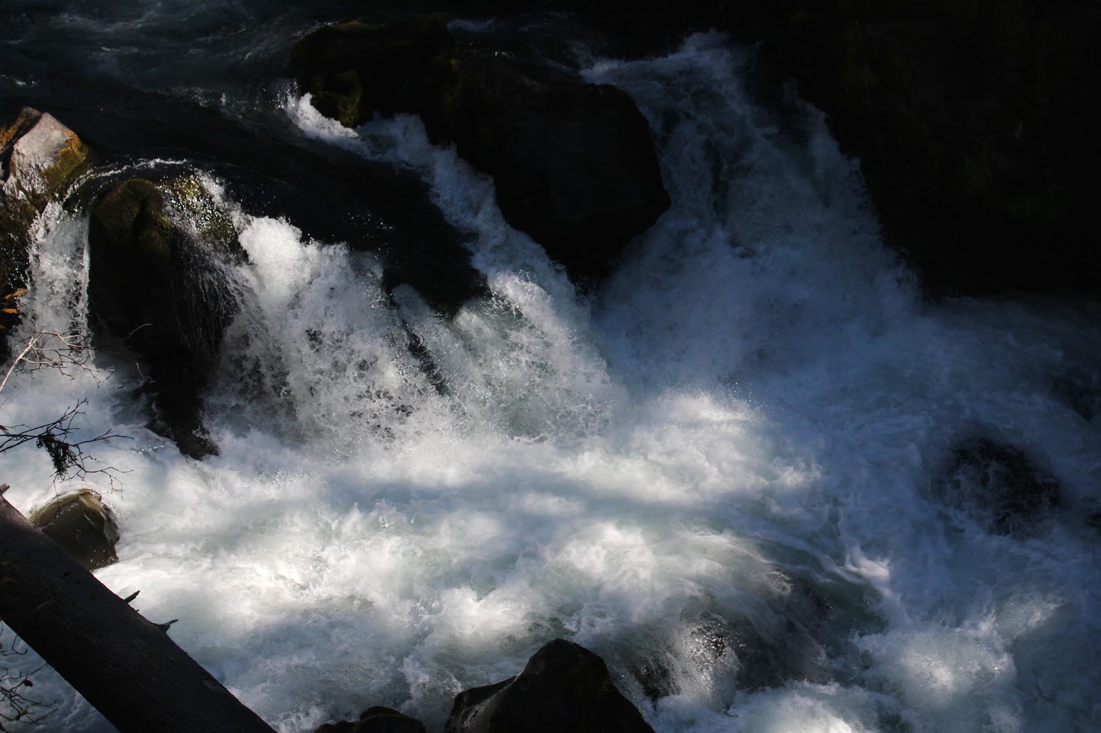
Nobody kayaks Takelma Gorge, I wonder why?
Takelma Gorge begins at what I call "The Fishook", a spectacular river U-turn surrounded by tall rocky cliffs. In testimony to the power of the river, large logs are strewn pell-mell, as if they had been tossed there in a Pick-up-Sticks game of the gods.  At The Fishhook, the Rogue River leaped down into the gorge and it was all noisy whitewater current here, no more placid and tranquil river for us! Downstream of the Fishhook, Takelma Gorge then ran straight as a laser beam for approximately a mile and we could look down a significant portion of the gorge.

Gorge geology lesson
The narrow defile was formed when Mount Mazama first covered the area with a huge deposit of volcanic ash, rocks, and sludge. Subsequent lava flows then covered the soft ash and subsequently hardened, so you had a layer of hard dense material covering a soft sludgy interior, a description that could aptly describe my head. At some point the river found a soft spot in the lava covering and like an earworm, burroughed into the soft material underneath the hard shell. Once the river found the ashy soil underneath, erosion took place and lo, Takelma Gorge was born. In the picture to the left, you can clearly see the layers described in this paragraph.

Decaying biomass, big and small
After a bit, the canyon deepened enough that the river disappeared from view, although its belligerent roar could always be heard. And shortly thereafter, the gorge flattened out, the river reappeared, went totally tranquil, and our attention returned back to the autumn foliage. It was like the gorge never was and once past, it was a pleasantly (relatively) level few miles to our lunch spot at the closed-for-the-season River Bridge Campground. It was a nice lunch and laze as we swapped hiking tales while Katie mooched bananas from yours truly.

British soldiers, a lichen
On the way back, Lane and I didn't take too many pictures (at first!) and kept up with everybody. But then Takelma Gorge looked so spectacular that we whipped the cameras out again, even though we had photographed the same things on the hike in. It's a disease, I tell you, and our symptoms increased when we returned to the vine maples upstream of the gorge.

Leaf-littered trail


I'm not sure how this happened but the woods had become even more spectacular than when we passed through in the morning. I'm not sure what it was but the colors were brighter and more colory, the vine maples had seemingly unfurled tons more of painted leaves and the autumn show was simply breathtaking. All hiking came to a screeching halt as we began the process of photographing every leaf in the forest.  Good thing I had the car keys!

Forest fire, vine maple style
We had long lost contact with our group, and several hiker groups passed by as we plied our avocation. Heck, we were even passed up by small children and arthritic 90-year old grandparents, but we didn't care. I made several attempts to seriously hike back to the trailhead but every new bend in the trail served up a new spectacular scene and our lack of progress got pretty ridiculous. Fortunately, my fellow hikers and club members have been well trained by experience and eventually, Lane and I made it back to the trailhead where our party was waiting patiently for us. Well, actually they were sleeping on the picnic tables, but why quibble?

Mother and child
For more pictures of this hike, please visit the Flickr album.


Sunday, March 16, 2014

Upper Rogue River Trail (Woodruff Bridge to Prospect Ranger Station)


There's a symbiotic relationship between work and hiking. Work is jam-packed with deadlines, claimants, deadlines, goals, more deadlines, and all sorts of other distasteful stresses (...like deadlines!). But hiking is my stress release and helps keep me sane. If you doubt I'm sane, take away the hiking and then see what happens. Hiking on weekends allows me to face another week day-slaving in a generically bland cubicle.

Mental floss


However, work allows me to go hiking too, as it pays for gas, boots, tents, food, parkas, sleeping bags, dehydrated food, bug spray, and ice cream on the way home. Plus, it's a great motivator to get out on the trail for my weekly mental floss. So, no complaining about work allowed, as hiking and work go together like a tamale and salsa. I may change my tune when I retire but that is a long way off, seeing as how I'm so young still and stop with the snickering already !

Let's go hiking!
The latest chapter in Richard's mental health therapy took place on the Upper Rogue River Trail with Medford hiking buddies Glenn and Carol (plus dog Katie). We had become friends when Glenn contacted me several years ago through my blog. Or as I like to put it: Glenn is a Leo, likes to take long walks, and we met through the Internet.  But we do not make a cute couple!

The first of several fallen trees
We left my car at the Prospect Ranger Station so we could hike one way from Woodruff Bridge to the ranger station. The morning was sunny and cool, just perfect for hiking as we started out. The Rogue River here is placid and serene with emerald pools of water lazily flowing just below the trail. Winter had been here not too long ago and we were reminded of that when we had to perform a tedious bushwhack to get around a freshly fallen tree.

Snow queen
Normally, this is a good wildflower hike in spring as the forest is carpeted with all manner of flowers. But again, winter had just departed minutes before we started our hike and the only sign spring was on the way were the little lavender flowers of snow queen. Apart from one solitary specimen of yellow woodland violet, that was it for the wildflower show. 

Takelma Gorge
The Rogue River soon became boisterous and noisy and at two miles, we arrived at spectacular Takelma Gorge. The river has cut a narrow cleft in the lava flows covering this area and is not very happy about being so confined, judging by the seething and roiling waters in the gorge. At a fishhook bend in the gorge, logs lie strewn about like spilled toothpicks of the gods. Even though I've been here bunches and bunches of times, the view never gets old.

Gorgeous gorge
The gorge would be our friend for nearly another mile and the river at times dropped completely out of sight in the narrow gorge. Much photography ensued when the river was visible. After the gorge petered out and the river went all mellow again, we stopped for lunch at Trail Bridge Campground as crows cawed crudely from the treetops. I became Katie's friend for life when she found out I had bananas which, oddly enough, are her favorite food.

Rapids on the Rogue
Up until this point, this had been a familiar hike as I've hiked to Takelma Gorge around a million times, give or take a 50,000 or two.. But the minute I stepped off of Trail Bridge and returned to the Upper Rogue River Trail, it was a brand new trail experience for me. Part of this section was also new for the Glenn and Carol contingent.

It's a Richard Hike!
After Takelma Gorge, the Rogue had returned to its easygoing persona but once past Trail Bridge, the river became a series of noisy and scenic rapids. It would retain that flavor for most of the latter half of the hike. The trail flavor changed too, as along Takelma Gorge the trail is mostly level, but here trail went steeply up and down the slopes above the river.

Part of the annual spring migration
At one point near the end, the trail peeled away from the river and executed a prolonged tour through the forest atop a level bench. Not particularly exciting after hiking all day along a scenic river, but that's what happens when you have to detour around private property. It was a welcome change to return back to the river which had changed personality again. We had started our hike along the wild Rogue River but now we were walking along the totally domesticated Rogue River, it's the river equivalent of what happens to a single man after he gets married (present company excepted!).

The Rogue gets tamed
The Rogue River pooled into inviting swimming holes behind a diversion dam at North Fork Park, near Prospect, and the dam spillway was putting on a noisy and thundering display.  It was Rogue's last hurrah before getting unceremoniously stuffed into water pipes, the water flow generates electricity so we can use our cell phones.

More mental floss
This was an 11 mile hike and, combined with the Dellenback Dunes hike the day before, the weekend produced nearly 20 miles of hiking. Mental floss of the first degree and I'm good for another week of work with maybe a little bit of overtime. 

Our view for most of the 11 miles
For more pictures, please visit the Flickr album, and for Glenn and Carol's take on this hike, click on this link.