Showing posts with label rogue river wilderness. Show all posts

Saturday, February 14, 2015

Rogue River weekend


As noted in previous postings, the weather has been quite nice lately, bypassing for the most part that whole nasty winter thing. Come summer I will beat my chest and tear out what little hair I have in loud remonstration about the hot and dry weather. However, taking a mid-winter backpack trip in decidedly spring-like weather is just one of those guilty pleasures that must be indulged in, never mind the upcoming fire season. 

Cliffy trails are another guilty pleasure
The Rogue River Trail is a perennial favorite of mine and besides which, the Friends of the Umpqua had a hike scheduled there on Valentine's Day. So, I packed my backpack and met the club at the trailhead on a gloriously sunny, albeit cool, day. Since I was all saddled up and was basically freelancing, I bypassed all the orientation formalities at the trailhead and got a head start on things.

Slowly, the moss stalks its prey
It was good while it lasted as about two miles into the hike, I was lapped and found myself in my customary position behind everybody else. In my defense, I was toting a heavier pack than normal because of carrying some extra night clothing and a sleeping bag liner due to predicted freezing night temperatures. But the main reason was that my leg muscles were atrophied from the winter layoff and who would have thought a 30 pound pack could be so darn heavy?

Why I love the Rogue River Trail!
The Rogue River Trail spends much of its miles hugging cliffs high above the river. Below the trail, the Rogue alternates between placid pools of green water and frothing rapids with rafts of screaming teenage girls shooting through. The forest is that odd Siskiyou mix of tan oak, laurel, madrone, and conifer. And plenty of poison oak encroaches the path, rubbing tri-lobed leaves of itchy madness upon careless hikers. Trails like the Rogue River Trail are why I love hiking, despite the heavy pack thing clinging to my back like a pregnant monkey.

Saxifrage
As mentioned, spring was in the air and the slopes were covered (in places) by yellow patches of Oregon sunshine (the flower, not the sunshine, although there was plenty of that too). Saxifrage clung to damp seeps on cliff faces and the grassier slopes offered oak toothwort and baby blue eyes. I took a few pictures in a practice run for the wildflower season that will be here soon.

Whiskey Creek
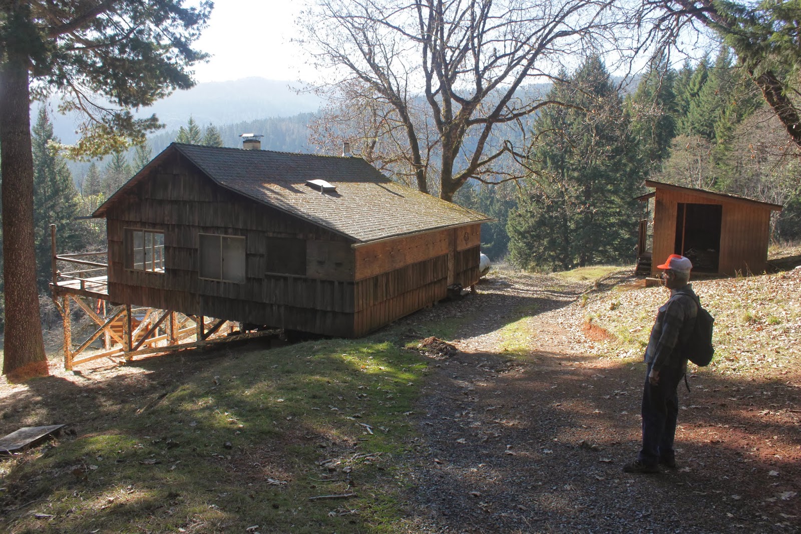
After visiting historic Whiskey Creek Cabin, the club backtracked to eat lunch at the grassy swale where Whiskey Creek meets the Rogue River. After lunch, I bid adieu to my friends and headed on up the trail. I had no real plan for the weekend but figured I'd do the 11.5 mile hike (now 12.5 miles due to the backtrack to the lunch spot) to Horseshoe Bend, then return back to Big Slide Camp the following day, with a short hike out on the third day. 

A totally awesome campsite
However, as the day wore on, I became less enthused about hiking lots of miles and began pondering the alternatives. Creeks Alder, Booze, Russian, and Bronco all had campsites but the campsites are fairly utilitarian and lack backwoods zazz. And just like that, a chance glance down a gully showed a grassy beach next to the river. Hello, future campsite of mine!

Night time comes to the Rogue River

Picking my way down a steep slope, I set up camp mere yards from the river emerging from churning Tyee Rapids. The rest of the afternoon was spent in sheer indolence, reading back issues of Backpacker Magazine with the noisy rapids as a backdrop. After dinner, a short hike to Russian Creek and back burned a few calories as the sun set. I had this riverside idyll all to myself which was fitting, seeing how it was Valentine's Day and I certainly was spending it with the one I love most.

There otter be otter tracks!
During the night, the noise from the river drowned out all other noises but I woke up on full alert anyway, my spidey senses pinging about intruders. I put on the headlamp and stuck my head out the tent and observed about four pair of shiny eyes bobbing and weaving next to the river. Like some slender wispy wraiths from the netherworld, the river otters silently disappeared into the darkness. You just haven't backpacked until you've shared your campsite with otters and how cool was that?

Tyee Rapids
The next morning an otter swam up to my beach and espied me sitting on a rock, eating breakfast.  With an ottery "Ulp!" it dove back into the river and swam further upstream for a more hiker-free landing. I surreptitiously followed but the agile critters (there were several) never let me get a picture of them. The beach ended at a pile of rocks next to rock-concert loud Tyee Rapids, and much awestruck gawking ensued,

The Rogue River Trail
The bad part about my most awesome campsite was that I had to lug my pack up a grassy slope dotted with scraggly and leafless oaks. Whew! After a short hike on a wonderfully shaded trail with small creeks running across the trail, I arrived at Big Slide camp in no time at all. I just couldn't see myself killing an entire day here, especially since all the magazines were read and all the crossword puzzles had been completed. So, I just put out a day early, totally happy with this easy hike in the unseasonably early spring sunshine.

China Gulch makes a splash
For more pictures of this hike, please visit the Flickr album.

Saturday, March 1, 2014

Rogue River Trail (via Whiskey Creek)


The Rogue River Trail is one of my Happy Places on Earth. Unfortunately, I've been on it so many times it's hard to get that kind of excitement one feels when a new camera arrives in the mail, just to cite one example. Because of the trail's proximity to Roseburg and because of the overall quality of this spectacular trail, even the Friends of the Umpqua Hiking Club was feeling ennui about the Rogue River. But leave it to Edwin to put some lipstick on the Rogue River pig! 

Hi ho, it's down the road we go!
Normally, we begin hiking at the Graves Creek boat ramp and turn around at Whiskey Creek Cabin. However, Edwin took us above the Rogue River and then on a rickety road that dropped about halfway down the river canyon. We began the hike by walking past a gate on the road and then dropping down to the cabin.


Flat trails are not overrated
Wow! The road dropped faster than a hard rock in soft water, even after accounting for the many switchbacks there to allegedly ease the grade. On the plus side, we arrived quickly at the trail to the cabin and we were all happy with the downhill hike at that point. Eschewing a Whiskey Creek Cabin visit (ennui, again) we made a right turn on the Rogue River Trail. Merle, John, and I had backpacked the RRT a couple of summers ago and we reminisced while the rest of the club giddily enjoyed the new trail smell as most had never set foot on this portion of the venerable trail.

Behold the mighty Rogue!
The trail was typical Rogue River Trail up-and-down on cliffs above the river and we passed the parklike glade of Big Slide Camp, the seething Tyee Rapids, and burbling creeks Alder and Booze. We had some sun and below the trail the river snaked gracefully around each bend. We didn't see any rafters as the river was coursing with the spring flow, it's nice to show Mother Nature some respect.

Spriiiing!
On the trail I saw this strange organism. It was like a plant as it had leaves but at the end of a stalk was dangling a strange colored thing. Someone told me it was called a wildflower. Yes, spring is coming and it was nice to see a grassy slope covered with Oregon sunshine, oak toothwort, and a lone fawn lily.


Please do not feed the animals


About a mile after crossing Russian Creek on a well constructed footbridge, we scrambled down a steep slope to lunch alongside the river. The sun was still out but more and more clouds were scudding in overhead as we ate. By the time we slogged back up to the trail, it felt like rain might be in the offing. Not surprising, considering the forecast called for an 80% chance of rain but apart from a lone 10 second shower, the forecast was off by approximately 80%.

On the trail with Talon and Kevin


I was feeling tired on the way back and probably the big climb waiting at the end had something to do with that. After nearly 4 miles of lollygagging and taking lots of pictures, it was time to head up to the car.  "Up" was the operative word as the road climbed 1,378 feet in 0.85 miles, or a 16% grade. I think I walked it about 20 yards at a time in between rest stops, accompanied by Kevin and his dog Talon. Kevin was walking at the same pace as me while Talon was merely putting up with the two of us.

Trees doing the forbidden tree dance
Right at the point where I had just about convinced myself to go find a new and less strenuous hobby, the yellow gate came into view and all the bad uphill stopped. I think I enjoyed the new hike experience and for more pictures of this hike, please visit the Flickr album.


Saturday, January 25, 2014

Horseshoe Bend

It's like an unwritten commandment in hiking:  Thou shalt not hiketh uphill to the car. Given that, there is probable cause for serving Edwin an indictment for breaking the aforementioned law, seeing as how we had to gain 1,840 feet over the last three miles just to get back to the car.  Edwin will be hearing from my attorney on this.

Tan oak leaf, working on the tan
The route, and I use the term loosely, was divined by reading an older map while wearing the happy glasses.  It followed a logging road dropping down the ridge way above the Rogue River and eventually would hook up with a trail that would finish off the descent to the river. Those hikers who are familiar with the Rogue River area are aware that the ridge culminates nearly 4,000 above the river and the topography is impossibly rugged.  So, naturally we (Edwin, his friend Richard, and myself, or ERR as we like to call ourselves) went hiking there!

Hiking on the logging road
Fortunately for us, the rickety logging road lost some elevation on the drive down, thereby sparing us some of that prodigious elevation gain on the return leg. The actual hike began at a locked gate well below the ridge crest. The forest here was absolutely gorgeous, consisting of a grove of stately firs with sunlight slanting through the branches. Periodic openings in the forest provided views of the very deep Rogue River Canyon with Mount Bolivar looming above it all,

Summer home and trespasser Edwin
The road dropped quickly through the forest before arriving at a very unexpected sight: another locked gate with signs stating "Private Property", "Keep Out", and "No Trespassing". After some debate and deliberation, we pretended we didn't see the signs or the gate and continued on down the road. 

Richard checks out a walnut orchard
After a short hike further downhill, the road arrived at a couple of summer cabins. Fortunately, this was not summer and it was readily apparent that the homes were not currently occupied so we tiptoed by as surreptitiously as possible considering we were totally exposed on a broad meadow/lawn in front of the homes. Deer were hanging about the homes so if anything is missing, I'm blaming the deer.

Trail down to the Rogue River
The good news was that just past the homes, there was a trail just inside the Rogue River - Siskiyou National Forest boundary. If anything, the trail lost elevation quicker than the road did and we dropped rapidly down the river canyon like snakes on a water slide. Any joy felt about walking downhill was tempered by the knowledge there'd be a whole lot of uphill hiking on the return. On the descent, the firs gave way to a forest of the largest madrone trees I've ever seen with tan oak and cedar mixed in. Poison oak, a Rogue River staple, also made an appearance and we made sure to look but not touch on the descent to the river.

Bridge crossing at a Meadow Creek fork
Despite this being an unofficial trail, there was evidence it had been maintained and brushed out.  A well constructed and sturdy bridge provided a safe crossing at Meadow Creek, "safe" meaning we got to keep our feet dry. After three miles of dropping through a lush Siskiyou forest with its odd little mix of conifer, cedar, oak, madone, and laurel the path spit us into what was obviously a man-made pasture. While the sun felt nice, the trail tread disappeared entirely, much to our consternation. While wandering aimlessly in the meadow, sharp-eyed Edwin espied the Rogue River Trail, passing below us about 20 yards away.

Our lunchtime view of Horseshoe Bend
We had arrived at Horseshoe Bend, although the campsites and gravel bar were a mile further east on the trail. It was as good a place as any for lunch, what with sunshine and a partial view of the bend and mountains above the trail. As much as we were putting off the big climb out, it was eventually time to go because the Rogue River was pretty much all in shadow as the sun got lower and lower in the sky.


Rickety barn at a homestead
So, it was up, up, up for the next 3-plus miles, past Meadow Creek, past the homesteads, past the two gates, past the beautiful forest as the shadows lengthened in the trees. It was pretty much sunset when we arrived at the car followed by the long drive to Mexican food, a warm shower, and lawyers.

Peek-a-boo!


For more pictures of this hike, please visit the Flickr album.