Sunday, May 24, 2020

Mildred Kanipe Park

Memorial Day, besides being the day designated to remember and honor our fallen soldiers, is also a traditional time to enjoy an outdoor meal, barbecue, or picnic with friends and family. Obviously, that can be difficult to do safely in the middle of a pandemic but nonetheless, daughter Anjuli and I went out for a hike among thousands of  other Memorial Day celebrants enjoying a holiday meal together. In this case, the celebrants referred to were hordes of crab spiders lunching and munching while flies, bees, and at least one grub did not share the enthusiasm about this Memorial Day food fest. Maybe we should pause to remember all our fallen insects too.

Hooker's Indian pink wasn't hard to miss
This was a tough Memorial Day for both Anjuli and I because in February, Aislinn passed and we respectively lost a sister and daughter. For whatever reason or maybe no reason at all,  we each were feeling the loss this weekend so a healing hike was in order. Anjuli lives just down the road from  Mildred Kanipe Park, making this little hiking jewel of a park the logical destination.

One of thousands of insect pics I took
The day dawned gloriously sunny and bright and we began hiking under a blue sky containing just a hint of summer haze. The rolling hills and oak savannas of the park were beginning to dry yet remained colored a springlike green for the time being. Wildflowers were going to be thing today and the grasses were well infused with pale blue flax among a million other species. However, flax was the most prolific flowering specie today, earning a well-deserved Most Profuse Flower award, although oxeye daisy gave flax some stiff competition.

A turkey entertained us for a few minutes
Anjuli is my daughter and she likes to take photos too. It's in her genes. Once we found out bugs were crawling and landing on a multicolored plethora of blooms waving in the slight breeze, all serious hiking came to a screeching halt. Clearly this would turn out to be more nature walk and photo shoot  than hike as we indulged our shared muse. Not all the animal wildlife was insectile or arachnid in nature as a turkey hen crossed the trail in front of us, not at all concerned with our presence in her home. 

This was a berry yummy hike at times 
After a short but time-consuming walk on a trail overgrown with grass that just felt like it was populated with a creepy population of ticks, the trail turned uphill and we both broke out in a sweat from the exertion under a warm sun (The final tally was just one tick found on Anjuli's pant leg). Off to one side of the trail were bunches of wild strawberry plants just going to fruit. The berries may be so much smaller than those you can find in a grocery store, but you just cannot beat the taste. 

Memorial Day picnic in progress
Once we attained the high point of this hike in a park-like glade of oaks surrounded by knee high grass, the ox-eye daisies began to supplant the blue flax blooming in the grass. It was about then that crab spiders became a thing on this hike, for nearly every daisy had one or more of them lurking in the petals. Many of them were lucky little spiders, having scored a fly or bee that unsuspectingly landed into the eight-legged ambush waiting in the seemingly safe blooms. The nadir of all the spider Memorial Day picnics came when we espied two spiders munching on either end of a thin grub. Anjuli extended a finger to point something out with the spiders when the darker spider jumped onto her finger, setting off a round of screams and squeals, along with some fatherly laughter.

Ferns in Fern Woods, who'd a thunk it?
We grabbed the loop trail running through Fern Woods and the trail was heavily encroached not only with ferns, but also with nasty and oily green leaves of poison oak. And me hiking with shorts on! The forest was wonderfully shady with the woods carpeted with millions of fern fronds competing with poison oak for ground space. It's called Fern Woods because a) there are an astounding amount of ferns growing in the woods and b) nobody wants to spend a sunny Sunday hiking in Poison Oak Woods.

A longhorn beetle better watch out for spiders
The path dropped out of the woods and descended through some through some grassy meadows and rolling hills before bottoming out next to muddy Bachelor Creek. Ox-eye daisies were the dominant life form here, and more bee and fly carnage by spider marauders entertained us. Life is cheap if you are a small insect here, for sure.

We ran a cattle gauntlet at the end of the hike
Kanipe Park is a working cattle ranch and we closed off the loop hike with a walk through wary bovines grazing in their pasture. We may have been equally and likewise wary of the large cow thingies as they were of us. We quickly learned to scan body parts to determine whether it be bull, cow, or steer, engendering some rather ribald conversations between father and daughter. At any rate, no mad cows confronted or accosted us as we returned to the park headquarters to the accompaniment of loud peacock hoots and turkey gobbles.

Anjuli jumps for joy
For more pictures of this hike, please visit the Flickr album.


Friday, May 22, 2020

North Umpqua Trail (Deer Leap Segment)

A funny thing happened on this hike. The hiking festivities on the Deer Leap Segment of the North Umpqua Trail commenced with a rather rigorous uphill slog and there was nothing to do but lower my head and attack the mad uphill charge. In short order, the trail crested and the hike continued on what would wind up being an up-and-down all-day thing. But, wait just a minute here! What just happened? Who didn't stop for rest breaks on the way up? Who was feeling pretty darn walky on this day? This dude, that's who! I've already managed a round shape so it's about time I started rounding into shape!

Raindrops keep falling on my head...
My retirement had not been going as planned. Initially, my vision was for me to become an uber-fit hiking and biking dude after ceasing engagement in any form of gainful employment. My intentions were good, but once I found out I could just sleep in, wave bye-bye to the uber-fitness regimen and say hello to general all-around slothitude. I did keep up a minimal token hiking schedule though, generally getting out onto the trail at least once a week. But, because of a notable paucity of any physical activity in between outings, my hikes had gradually became shorter and less challenging. Clearly, a change was needed and lately, a mostly every-other-day schedule has been adopted and implemented.

A small waterfall was
the turnaround point
Some mental acuity should be incorporated to go along with the physical exercise program because at the trailhead, it was discovered my socks and liner socks were still sitting on the living-room couch, where they did me no good at all. Additionally, my boots had recently seen duty a couple of days prior on the Briggs Creek Trail, and that particular hike included a wet ford across Dutchy Creek. Not only were my boots still wet, but Dutchy water mixed with stinky feet offal was noisily sloshing inside. Nothing to do but stick my bare feet in cold, wet, and stinky boots and commence hiking. That'll teach me. Maybe.


Rain beads up on a skunk cabbage leaf
Speaking of wet and cold, it was raining as I set out on the Deer Leap segment, beginning from Toketee Lake. Three weeks ago, I had tried to hike this segment from the Medicine Creek side but didn't get very far due to a destroyed bridge, courtesy of a ginormous rock rolling down from above. Hiking west from the Toketee Lake end of the trail segment, there was very little chance of encountering smashed  bridges or deep creeks, so my chances of getting in a decent hike were pretty good, lack of socks notwithstanding.

Eminently green trail
Anyway, up through the forest in the rain I go and yay, my sockless legs were certainly under me today! Once the trail crested, the sun came out and let's have another yay, it might even turn out to be a sunny day. Not really, though, this was "raisun" weather, alternating rapidly between rainy and sunny throughout the day.

Devil's matchsticks light up a rock
Spring was in full song with a lush and verdant forest bursting at the seams with rampant greenery and scenery. If you love a luxuriously green forest, then you will absolutely love this section of the venerable North Umpqua Trail. Wildflowers were also going at it, mostly due to whitish colored species such as Columbia windflower, candy flower, yellowleaf iris, false Solomon's seal, and the like. For a some non-white color variety, I did come across the first pink woodland phlox and rhododendron flowers seen (by me) this year, but not certainly the last.

Candystick emerges from the depths of winter
A moment of hilarity occurred when I ran into the only other hiker I'd see on this day. Her dog was clearly out of its element out in the woods and was jumping nervously, looking over its shoulder at every sound like the city-slicker fraidy-cat canine it was. Throw in a scary but incredibly handsome hiker into the mix and dog therapy was clearly going to be required if the erstwhile household pet was ever going move on from this traumatic and mentally scarring event. That dog was not going to walk by me on the trail at all, no sir, no how, no way. However, when the hiker did go past me and called to the dog the pooch tentatively tip-toed past, breaking out in a terrified run and yelp as two humans laughed in uproarious amusement.

Trail through the rock garden
The middle portion of this hike was the coolest part, though. Apparently a large avalanche occurred so many eons ago, to go along with the formation of basaltic cliffs and other rock formations. During the subsequent epochs, a forest sprung up around the rocks so what you have now is about a mile of huge boulders and forbidding cliffs interspersed with trees, all covered with the ever present blanket of moss. The trail snaked through the rocks and I really enjoyed hiking in this North Umpqua-style zen garden.

There's a river down there somewhere
Although this was the North Umpqua Trail, which in theory follows the North Umpqua River, the truth is the Deer Leap Segment is high, well inland, and ensconced deep within a dense forest above the river. Naturally, the North Umpqua is hidden from view, although it could always be heard through the trees. Besides the usual river noise, a deeper riverine roar emanated from scenic Toketee Falls at one point; too bad the spectacular waterfall was hidden from view. Apparently (later confirmed on the map) the river made a sharp bend for the trail crested at a forested saddle where the river could be heard from both front and rear. Near the saddle, a small break in the trees provided a partial view down the impressive river canyon.

It's about the journey and not the destination
The entire Deer Leap Segment is between eight and nine miles long and I was not going to hike the full segment as an out-and-back. I may have been feeling walky but sixteen-plus miles would have sorely abused my newfound energetic mood. Instead, the basic plan was to hike at least four miles in and then, solely based on weather and/or fatigue, more formally at which arbitrary mileage number to turn around at. The whole of this mileage dissertation is to state that basically, this was a hike without any real sense of destination.

My lunchtime view


All that changed when an unnamed seasonal creek waterfalled down a mossy rock face, landing photogenically into a splash pool next to the trail. This made a nice spot for lunch, relaxation, and peaceful contemplation and I so obliged. And best of all, it met the criteria for a logical turnaround point. After a healthy recharging of soul batteries, it was time to turn around and hike back in the rain or sun, depending on the rapidly changing moods of the sky above.

Life, or at least this water drop, hangs in the balance
After the hike was done, I felt pretty good as my boots were removed at the car. All the ups on this up-and-down hike had not been as daunting as normal. In fact, my legs still had more miles left in them after this 8'ish mile walk. Plus, the sublime forest beauty left me a little more at peace than when I had started. However, my feet did not have a lot more miles in them as they were pretty well chafed after eight miles in wet boots with no socks. I'll have to keep this hiking and mental regimen going because one should not waste an ample mind, but one should mind an ample waist.

The North Umpqua Trail rocks!
For more photos of this hike, please visit the Flickr album.


Tuesday, May 19, 2020

Briggs Creek

You might say Briggs Creek owed me one. In late March and at Cathedral Hills in Grants Pass, packs of wild rubes non-compliant with social distancing made me run away in terror to Briggs Creek, where I found myself both mapless and GPS-less, When the Briggs Creek Trail ran into a gravel road without any obvious resumption of the trail, the hike was called off at that point. But really, Briggs Creek doesn't owe me thing. It knows exactly where it is and where it is going and needs no stinking map and it wasn't the creek's fault I showed up without any means of geolocating myself or the trail. The creek simply does what it always does, which is run through the forest while befuddled hikers try to figure out where they are.

A fellow hiker out and about on the trail
But this time out, I was fully prepared. There was a map in my pocket and the GPS even had new batteries in it. When this particular hike rendition began at Sam Brown Meadow's trailhead, it was apparent that a lot had changed in the intervening month and a half or so since my last visit to this locale.

The greenery exploded from my last visit here
First off, the trail was eminently green. There was a veritable jungle growing beside and in some instances, over the trail. What a difference! Along with the lush spring growth, a million little wildflowers were blooming and all manner of buzzing insects, ants, and aphids were happy. The camera also was happy with the rampant greenery and was kept quite busy on the resulting slow hike. 

Skunk cabbage "perfumes" the air
It had rained for most of the week and the trail was fairly muddy and there were a few "whoops!" moments (but no pratfalls) on the way. Water collected in low spots and between the trail and hidden Briggs Creek was a damp bog full of an entire metropolis of skunk cabbages perfuming the trail with their rubbery skunky odor.

Dutchy Creek capers and frolics across the trail
After a mere half-mile or so, the trail abruptly disappeared into what I mistakenly identified last time as Briggs Creek. That's what happens when you have no map, GPS, or general knowledge of the layout, you don't even know what creek it is. Anyway, Richard meet Dutchy Creek and vise versa. Now that we were properly introduced, it was time to commence a more intimate acquaintance with Dutchy Creek in the form of a wet wade. What had been an ankle-wetting wade a few weeks ago was now about six inches above the knee deep. Why does Richard cross the creek? To gather material for his blog, of course. To get to the other side would be the more utilitarian reason, though.

A most bucolic setting
A short walk on a lush trail with Siskiyou iris, pretty face, and wallflower blooming all around led me to my former nemesis, the heretofore unidentified gravel road. I say road, but really it was more of a rough jeep track that probably services the ATV crowd. A quick consult with the GPS divulged that the road was actually the trail for a bit so it was "Hike on!" again.

Brushy Creek runs across the trail
Brushy Creek would also have been an ankle wetter but some enterprising soul had tossed a thick board into the creek and that just turned the creek into mere boot sole wetter. At this point, the trail peeled off to the right and became a genuine path instead of rough road.


A lot of the forest looked like this
All through this hike, the trail was surrounded by scars from the Taylor Creek Fire of 2018. In most places the flames had merely singed the trees while clearing out the undergrowth. Past Brushy Creek though, the fire had really done some serious damage to the forest, for most of the trees were either dead, dying, or both. In fact, some of the hardwood species like madrone still had dead leaves remaining on their blackened limbs, nearly two years after the actual forest fire. But in a burn zone, the "healers" move in when trees die off and this forest was no exception.

Bracken fern takes over the burned area
When the trees die off, sunlight reaches ground level in what had once been a shady forest. Accordingly, sun-loving vegetation takes over, thriving in the open sunlight. Fireweed, bracken fern, sword fern, vanilla leaf, and the ever ubiquitous vine maple had created a relatively low growing jungle that rendered the trail slightly sketchy on occasion. The ample vegetation attracted butterflies, beetles, bees and flies while songbirds twittered in the brush and woodpeckers jack-hammered the blackened snags. The burgeoning life flourishing at ground level below acres of death in the form of dead forest, visually made for quite a striking contrast.

Briggs Creek was always nearby
Briggs Creek had initially been hidden from view by forest and vegetation but as the miles clicked off, it became more consistent in remaining semi-visible, always flowing relatively near the trail. The stream was moving fairly deep and swift in places, and some of these swimming holes might be fun come summer.


Elkhorn Mine, no longer an ongoing mining concern
The only real landmark or point of interest with any sense of destination was Elkhorn Mine. It may have been an actual mine in the past, but today it is a rustic campsite cum picnic spot with a couple of chairs and one card table underneath an invitingly lush forest. There were large and rusty pieces of metal strewn about that I can only surmise were related to the site's former incarnation as mine. Here, the trail became jeep road once again and the former mine now has that air of backwoods idyll for the motorized crowd. 

The trail disappears into the forest on a darkening day
Feet got wet crossing Elkhorn Creek flowing across the track, and it was time for a quick consult with the map for an idea of how much further I'd be walking. Not very far, as it turned out, for the trail made a crossing of Briggs Creek about a quarter-mile ahead. Comparing Briggs Creek to my nearly waist-high crossing of relatively tranquil Dutchy Creek, the idea of battling a much deeper and much faster moving creek wasn't all that appealing, especially since the sky had clouded over with that expectant air of impending precipitation.

Sproing!!!
Although this hike was not very long, coming in at 5.6 miles, the full Briggs Creek Trail is something like ten miles long end-to-end. It might be worthy of a backpack trip in summer when the creek fords are more manageable. In fact, Briggs Creek might even owe me another hike out to this beautiful and idyllic area,

A beetle with a fake set of mandibles painted on it
For more photos of this hike, please visit the Flickr album.


Saturday, May 16, 2020

Little River Waterfalls


I had choices. I could have gone hiking on Friday but procrastination won out. Hiking was put off for one more day, making Saturday the day to engage in my favorite activity. Naturally, Friday had been a perfect day for hiking: sunny, cloudless, and comfortably warm. And of course, Saturday turned out to be windy, rainy, and cold. That's why in the O'Neill household, I'm not allowed to make any decisions related to anything other than hiking.

Wolf Creek Falls dwarfs all


No complaints though, the theme for the day's hikes was all about waterfalls, even if that meant water falling from the sky on occasion. There are four short waterfall hikes up Little River Road, and I don't hike them much at all because they tend to be on the short side. However, by doing all the cascades in a single day, reasonable trail mileage can be accrued, justifying the effort and trouble of driving to three different trailheads in a single day.

Quality forest time near Yakso Falls
The first hike turned out to be a bust though. The road to Grotto Falls was heavily covered with trees felled by winter weather. Somebody had cut a car pathway out of all the timber litter but there wasn't a lot of room between the sawed-off logs and my wide and reasonably pristine Jeep. As the debris kept increasing with frequency and intensity, I eventually turned around and figured I'd see what condition the road to Lake of the Woods was in. In hindsight, I could have just parked and walked down the road to Grotto Falls but that just didn't occur to me at the time. Oh, well.

Lake of the Woods, as a breezy storm rolled in
As it turned out, Little River Road, once it turned to gravel, had also experienced fallen trees but nowhere near the volume and ferocity encountered on the road to Grotto Falls. Plus, the road was wide enough for two cars so the trees never encroached my precious vehicle on the drive to Lake of the Woods, the trail nexus for two of the waterfall hikes on my prospective itinerary. From the small lake in and of the woods, trails lead to Yakso and Hemlock Falls, and just because and for no other reason, Yakso Falls was elected to be the first hike of this overcast and dark day.

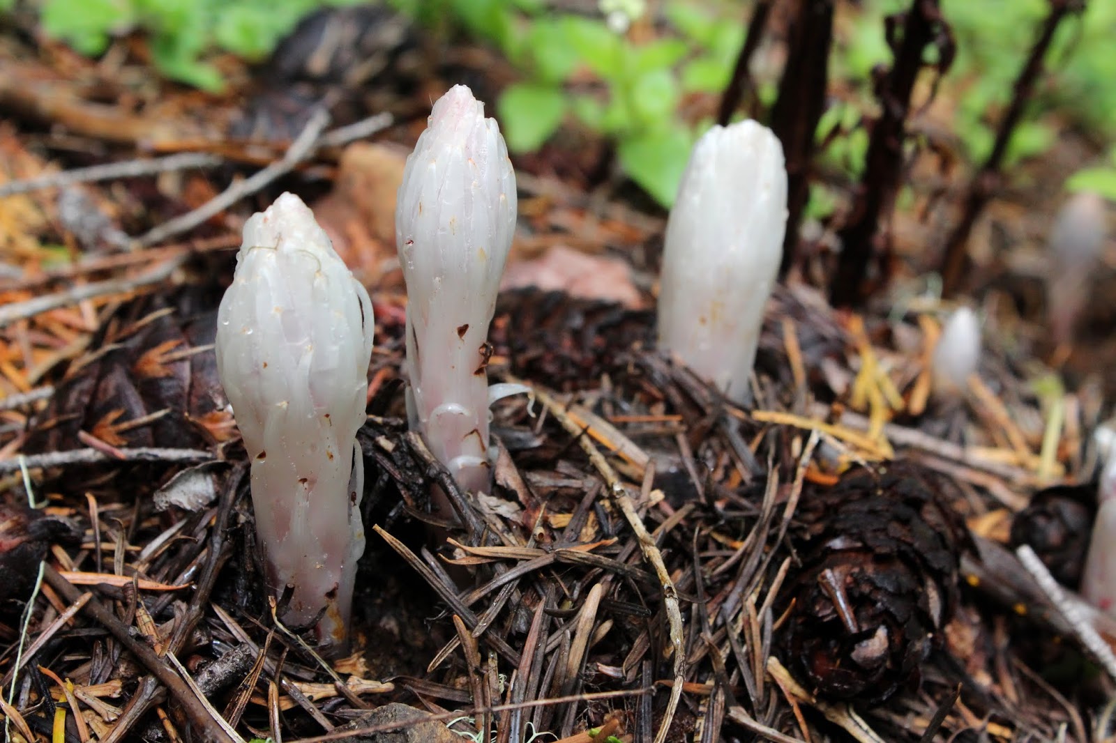
Drab flower in spring, juicy berry in late summer

These trails see a lot of use, and accordingly the path was wide and well maintained. The woodland approach climbed gently uphill as it rounded a forested ridge. It was a veritable jungle what with dense vegetation consisting of vine maple and pretty much everything else flanking the trail. In late summer, the hike to the falls must be berry nice, based on the amount of huckleberry flowers blooming on the tall bushes.

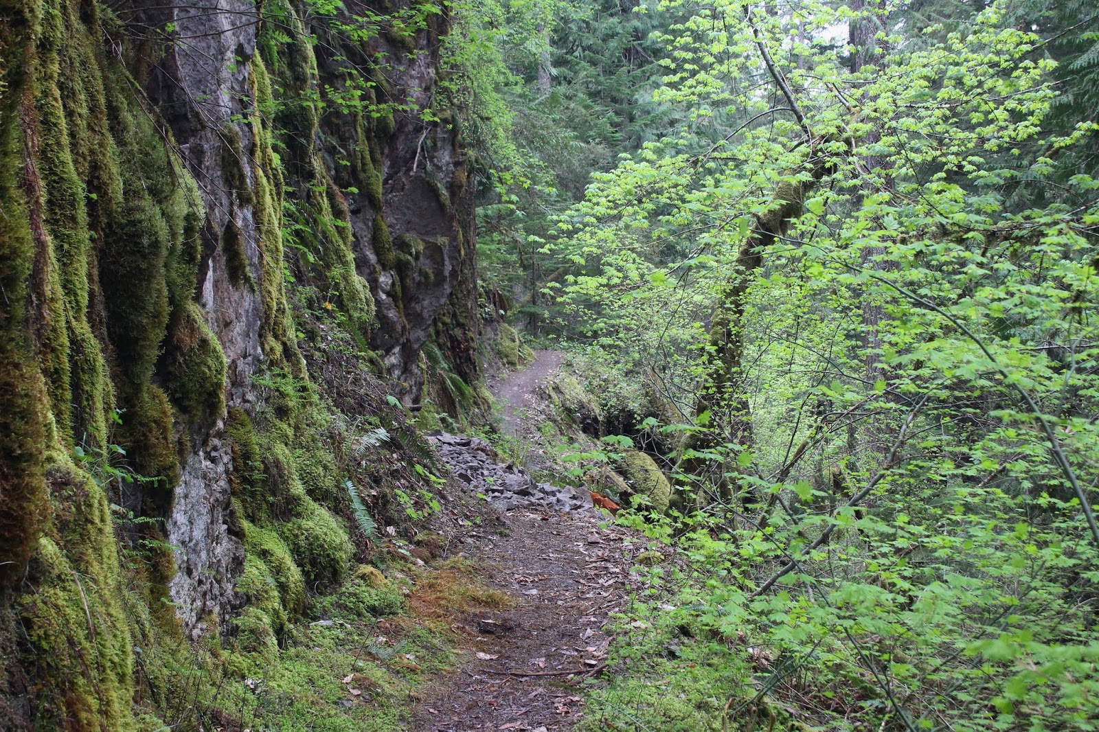
The dividing line between geology and forest
Eventually, Little River was spotted flowing well below the trail and after the path hugged a formidable mossed-over cliff, Yakso Falls hove into view. This time of year is the best time to see waterfalls as all the rivers and creeks are rain swollen and put on quite the show when it comes to cascades, and Yakso Falls was no exception.

Yakso Falls

As I had mentioned, the day was pretty dark with impending inclement weather coming in, the gloominess of the day enhancing the white water of the falls glowing nearly luminescent in its rocky bowl. Much photography ensued and a fair amount of time was spent just taking in the splendor of the falls, both on a photographic and metaphysical spiritual basis.

Trail signs in the age of coronavirus
After the 0.6 mile hike back to the trailhead, I crossed the road, hopped over the Lake of the Woods Campground gate (closed due to the pandemic) and walked past the small lake to the Hemlock Falls trailhead. Where Yakso Falls was on Little River, Hemlock Falls does its thing on Hemlock Creek. And while the hike to Yakso Falls had been fairly mild in gradient, the trail to Hemlock Falls dropped rapidly down to Hemlock Creek in alarming fashion, with the dreaded opposite effect coming back out.

Hemlock Falls tumbles down its cliff
Hemlock Falls was predictably spectacular and like Yakso, much photography and recharging of soul batteries ensued. I think there might be more to Hemlock Falls than what can be seen from the splash basin, for at the top, it seemed like the noisy cascade was already a pre-existing condtion before becoming the visible spectrum of Hemlock Falls. The creek has cut a deep canyon here and when trees fall, they apparently tumble all the way down to the creek, for the cascade's splash basin was littered with a plethora of trees long since mossed over.

Some of that rushing water on Hemlock Creek


After the steep hike back to Lake of the Woods, where a certain lone hiker said "ugh!" a lot as he trudged uphill, it was another drive on Little River Road to Wolf Creek Trailhead. Wolf Creek Falls are extremely popular with the casual hiking crowd and since this was the first week of partially relaxing the pandemic stay at home order, there were no expectations of encountering solitude on this hike. And sure enough, expectations were borne out by a full parking lot at the trailhead.

Wolf Creek Trail was lined with candy flower

This hike began in spectacular fashion on an arched footbridge spanning Little River just upstream of Wolf Creek. Once the trail entered the lush forest thriving at the bottom of Wolf Creek's canyon defile, it was apparent this would be more nature walk and photo shoot than actual hike. The greenery was profuse and dense, and the wide path was lined with white Columbia windflower and diminutive candy flower.

Columbia windflower was abundant
While windflower and candy flower were a constant throughout the hike, other bloomers also flowered up the joint, notable species thereof being sea blush, starflower, thimbleberry, inside-out flower, and Hooker's fairy bell. Sword ferns were a thing too, with their "elephant trunks" not yet being fully rolled out into the more familiar fern fronds.

Wolf Creek flows past a rocky bench
Wolf Creek was also a constant on the left side of the trail, although it wasn't always easy to see the creek through the vegetation and forest. But when the creek was visible, the water was notably silty and opaque as the stream burbled and babbled at the bottom of its green and mossy creek bed.


The upper Wolf Creek Falls
After a short climb near the end of the trail, the lower half of magnificent Wolf Creek Falls became partially visible through the trees. The falls are a two-stepper and both parts of the falls are stunning in their watery beauty. However, the lower falls are not visible from the viewpoint but can be enjoyed from the trail leading up to the viewpoint.


Lower Wolf Creek Falls was visible from the trail
Since this hike was all about the enjoyment of water, it stood to reason that of course, it would start to rain as I enjoyed the roaring cascade. The precipitation wasn't too bad at first, but would increase on the hike out. On the return leg, the wind picked up, the rain fell a bit steadier and the camera was stowed away to aid in getting back to civilized dryness as soon as possible.

The silty waters of Wolf Creek
Despite the wet weather, it felt like a pretty good choice to hike on this wet day instead of the glorious sunny day before. Lest I feel too good about that decision however, the following day dawned sunny and warm. That figures!

Simply elegant starflower
For more pictures of these hikes, please visit the Flickr album.