Saturday, April 28, 2018

Sutton Creek

It nearly shames me to say I led a hike that was only 5.6 miles long. And on a well-groomed and tame trail, to boot!. I must be getting soft in my dotage, how else to explain this? However, to my few detractors, my snappy comeback retort and rejoinder is "hey, you should have seen me last week!"
Swingin' Patty of the Dunes
Several years ago, I had cobbled up a route through dunes and forest after drinking several late-night beers while perusing satellite images in the Sutton Creek area. Following a network of faint game trails through brushy Alder Dunes, my route (which will never appear on any maps) also wound up splashing through knee-deep marshes before reaching the beach. The return from Sutton Creek's mouth was a bushwhack along the wide creek, where the bushes whacked back. Way fun, and I just had to do it again and bring a few unsuspecting friends along too. One can never have too many friends and hikes like that are why I don't.

See the trail? Me, neither!
Let's quit reminiscing though, and get back to present tense. On my scouting trip the week before the official hike, the first thing I noticed once I left Alder Dunes Trail, was that the brushy dunes had gotten brushier over the intervening years since my last off-trail sortie. Apparently it was even too brushy for the local fauna, for there was a definite paucity of well-defined game paths through the dunes. However, I did make it to the correct corner of a rectangular-shaped dune, and from there, I entered the forest.

See the trail? Me neither!
Several years ago, this was the toughest part of the route and now it was nearly impassable as the sketchy deer path was presently a robust thorny gorse habitat. Amazingly, some intrepid soul had actually sawed through fallen trees and had lopped some of the growth back. Thanks, but I'm not sure how much that helped, it still was tedious and tough going, although Luna (my dog) thought this bushwhacking stuff was more fun than a bucket full of squeaky toys. Why she wasn't all scratched up by the thorns is a mystery, but there certainly wasn't any mystery about my scratched up legs, though. The growth was so dense and thick that even though Luna was leashed a foot or two in front of me, she was nigh invisible in the heavy vegetation.

Luna, happy to be a dune dog
Right there and then, I began planning an alternate route to Baker Beach Dunes but where there previously existed a muddy shortcut to the expansive dunes, an impenetrable wall of small trees and large bushes now blocked the way. So onward with my former adventure route it was.


See the dog? Me, neither!


After a three-quarter mile wade through standing knee-deep water in thick forest, the sandy dunes between Sutton Creek and the beach came into view. Luna was disappointed all that wading was finished while my boots were glad to be out of the water. Unfortunately, a deep marsh lay between us and the beach so I waded over to a log pile in Sutton Creek and clambered over to the opposite bank while Luna joyfully swam across and back several times.

Why bushwhacking is hard


So, the following week, I led all hikers on a wide and well-maintained trail through the coastal forest, hanging my head down in sheepish embarrassment. Not that I particularly care if people get mad at me or not for leading them on a bushwhack/swamp wade, but with visibility being limited as it was by all the thick and scratchy vegetation off-trail, there was a distinct possibility of misplacing a hiker or two on the bushwhack route. Lawsuits can be so expensive.


Rhododendron graced the forest
That's OK, though, the easy trail and short nearly six-mile distance allowed all hikers to enjoy a magnificent spring day on the Oregon coast. The sun was out in full blue-skied glory, yet the temperatures were cool and mild in the shaded forest, just perfect for hiking. The spring flowers were putting on a show with tall rhododendrons providing large pink bursts of floral color throughout the forest.

Vancouver ground cone
Vancouver ground cone, growing well out of its normal range, was sprouting everywhere underneath salal bushes, providing Professor O'Neill several opportunities to lecture his acolytes on this unique and uncommon saprophyte. Plus, Professor O'Neill took lots of photographs of said saprophyte.

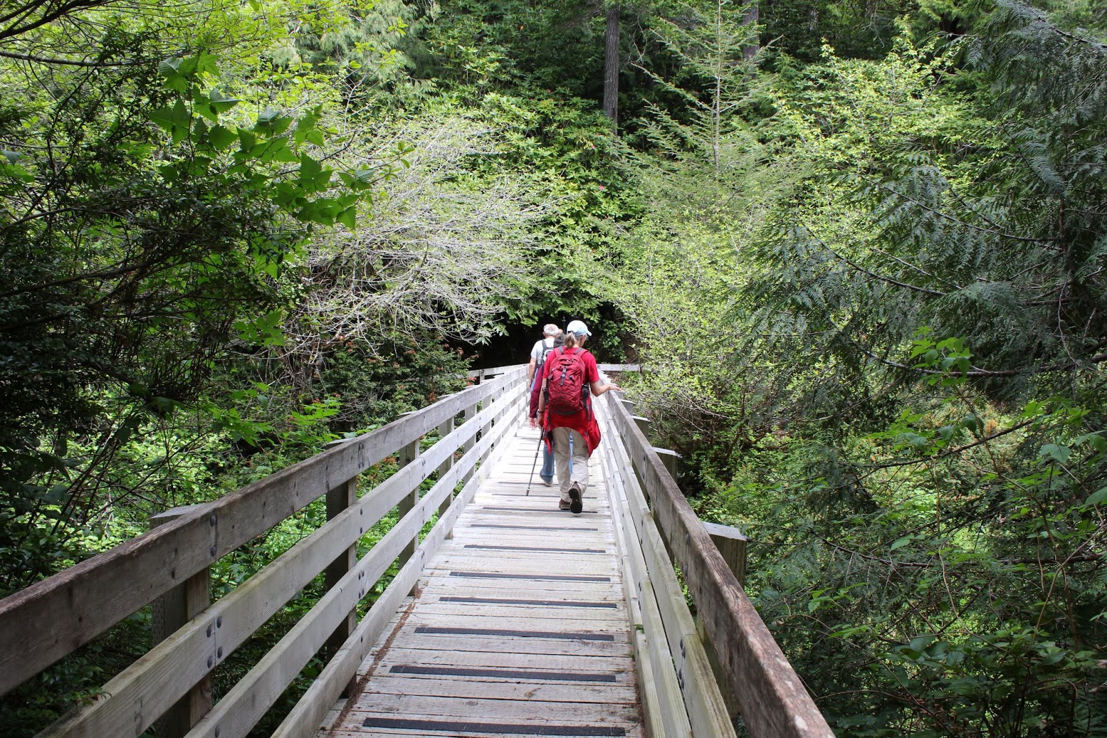
The campground host led us to this bridge
We did get somewhat "confused" (not "lost") when our route took us through Sutton Creek Campground but the kind camp host pointed us in the right direction and we resumed hiking on a trail. Ironic, considering we can all navigate dirt trails in our sleep, but get totally flummoxed by a paved road and civilization. Clearly, in a campground and roadway, we were out of our native habitat and comfort zone.

Yeah, sure, I'll go on the next bushwhack!
So, although the hike was short and easy, we were able to finish the hike with same number of hikers we started out with. Plus, all hikers returned with the same amount of skin they began the hike with. Double plus, boots stayed dry, although that's not always a top concern of mine. And lest anyone complain about the ease of the hike, well, they can come with me on my next bushwhack adventure.

Let sleeping snails lie
For more photos of the two Sutton Creek outings, please visit the Flickr album.


Below, is the bushwhack route. Do not attempt to hike this unless you have routefinding skills and are comfortable navigating in viewless forest. Be sure to take a map and compass!


Saturday, April 14, 2018

Taylor Creek

Spring has arrived, putting a spring in my step! Oh, there'd been hints, whispers, and innuendos that spring was on its way but this hike on the Taylor Creek Trail was the first hike this year where I could just smile and say "It's spring!" And accordingly, I spent much of my trail time lying prone, photographing the many wildflowers growing along the trail. Still had be careful about where I lay though, due to the many fronds of poison oak likewise growing along the trail and keeping the wildflowers itchy company. Not all of spring is good, apparently.

A tale of five bridges
The last time I had hiked on the Taylor Creek Trail, the many bridges crossing and recrossing the creek were rotting and you crossed at your own risk. The mountain biking crowd had given up on the bridges altogether and had blazed their own trails and wet fords next to the sagging spans. However, according to the U.S. Forest website, our fine friends at the Siskiyou Mountain Club had recently replaced the treacherous bridges, and I just had to go see for myself; especially since I am leading a hike here in a few weeks.

Unerringly straight through the forest
Taylor Creek may be just a small creek, but it has carved a massive canyon in the short run from its headwaters to the Rogue River. In fact, I often say Taylor Creek is like the Rogue River Jr. Well, that's not factually correct as I really don't say that often at all. In fact, I hardly ever talk about Taylor Creek but I have been known to make that observation after past visits to Taylor Creek.

Pasture at English Flat
Anyway, since the road stays high above the canyon, hikers get to warm up by hiking downhill. That's a nice feature, although its not as nice coming back after nearly 10 miles of hiking. No matter how great the hike was, it's just wrong to have to hike uphill to the car. As the trail lost elevation, the surrounding forest had that typical Siskiyou vibe of tan oak, madrone, and conifer trees all mixed together. After the quick downhill walk to reach Taylor Creek reposing at the bottom of the canyon, the trail spit us (me and my imaginary friend) out onto the grassy meadow at English Flat.

Stately trillium
I don't know much about the history of English Flat but it had obviously been a homestead back in the day. The grassy pasture and rogue fruit trees blooming next to the creek were a clue that this site had been settled, probably by an English family or by a family named English. The English may have even been English, for all I know. Blooming maple trees surrounded the once and former homestead, and the ground underneath the trees was carpeted with elegant tri-petaled trillium blooming away in glorious profusion. 

Taylor Creek flows under a bridge
The first bridge crossing of Taylor Creek was a beauty, nearly a work of art. Sporting brand new unweathered wood, rising high above the creek, with graveled on-ramps, the well constructed bridge merits a grateful tip of the hat to the crews that built the bridge. It sure beats wading across, and I speak from personal experience, having deemed some of the former rotting bridges too dangerous to cross on foot.

Fawn lily was everywhere
Once across the creek and back into the forest, the trail headed uphill for a rather brisk and protracted climb up and away from the canyon floor. I was feeling pretty walky and actually enjoyed the uphill hiking, ignoring the screams and shouts from protesting leg muscles. Despite the relative speed of my hoofing it up the trail, I still found some time to take photos of the myriad flowers blooming next to the path,

Exotic looking calypso orchid
The forest was carpeted with snow queen, trillium, hound's tongue, and woodland violet, just to name a few of the usual suspects. However it was fawn lily that rightly earned the Most-Profuse-Flower Award, as their distinctive nodding blooms made their presence known nearly everywhere on this hike. I also spotted my first calypso orchid of this year, the wildly festive bloom in the relatively drab forest seemingly as incongruous as a Rio carnaval dancer at a Puritan quilting bee.

Burned Timber Creek flows through
a tangle of unburned timber
With all the rain we'd been receiving in the buildup to spring, it stood to reason that there'd be creeks running across the trail. A few of them were ankle-splashers on the wade across while the larger streams had boardwalks thoughtfully provided to keep hiker's boots relatively dry. Most of the creeks were unnamed with the notable exception of Burned Timber Creek.

Picturesque waterfall on Burned Timber Creek
Burned Timber Creek is one of the star attractions of this hike as it joins up with Taylor Creek in a spectacular and camera-friendly waterfall. The cascade is not all that visible from the trail so a brief off-trail excursion to an overlook is required, and is well worth the relatively minimal effort.


Trail, as it hugs a rock face
Taylor Creek was not always visible but was always heard from the trail, except for one particular stretch of trail. For some strange reason, the path peeled away from the creek and charged uphill, causing me to curse trail designers all over again. After cresting a dry ridge, the trail then dropped back to Taylor Creek in what was a senseless and gratuitous abuse of quad muscles.

Where two creeks collide
After walking on a cliff edge, crossing two gravel roads, and experiencing a whole lot more ups and downs on a forested trail, the way straight across was blocked by two creeks running into each other. I had always thought that because the road next to the twin streams is Minnow Creek Road, that surely must mean this was Minnow Creek running in front of me. Wrong again, sardine! A quick perusal of the map divined that Taylor Creek and the South Fork Taylor Creek were the two creeks colliding in the middle of all the twiggy branches overhanging the twin creeks.

Oak toothwort
After crossing the two creeks on yet another pair of brand new, beautifully constructed bridges, I reached my turnaround point, another bridged re-crossing of the South Fork. A bear had shown great disrespect to the bridge builders's work by crapping right in the middle of the graceful span. On a prior Taylor Creek Trail ramble, when I was feeling amazingly walky, I had continued on past this point, climbing a steep trail to Lone Tree Pass, a nondescript trailhead on a forest road. As I climbed up to the pass, as the South Fork grew smaller and smaller, eventually dwindling to nothingness like that little point of light on an ancient TV monitor. I'm dating myself here but those of you who remember TV's before color, cable, and solid-state electronics will understand.

Moss creeps on a rock
Anyway, that climb to Lone Tree Pass was tough and not particularly scenic, and the hike up to the pass and back wound up being something like 14 miles long. By turning around at this particular bridge, today's hike wound up being just under 10 miles, a totally respectable distance. On the way back, the downs became ups and vise versa, through the same pleasant woods I had hiked through. On the way back, I took less pictures, simply happy to be fast-walking (on the Taylor Swift Creek Trail?) in the woods, until the last uphill push to the car. Wasn't so happy about that, nosiree. But up until then, this spring walk had definitely put a spring in my step.

Candy flower
For more pictures of this hike, please visit the Flickr album.

Saturday, April 7, 2018

North Bank Habitat (west Loop)

The weather forecast again called for rain so it was just me, John, and 3 first-timers at the trailhead. One of the first-timers was shaking hands and introducing himself "Hi, I'm Ed". Hey, I know Ed! Back in a previous life, I had worked 13 years at a mushroom farm in Watsonville, California. So did Ed! It turned out that Ed is also a good friend of a colleague of mine when I worked for the government, and life coincidentally took us both to Roseburg. So here we were, 27 years since we last worked together, reminiscing on the trail about the farm and the people who worked there. Small world, as they say.

Maple trees are still leafless, but not bloomless
And speaking of old friends, the North Bank Habitat is just that. It's close to Roseburg and the trails are mostly snow-free all year and are always reliably scenic, even in bad weather. And when the aforementioned bad weather keeps us from hiking a scheduled hike at higher elevations, the North Bank is always quietly accepting as a backup destination, despite our constant philandering with other more glamorous hiking destinations.

Uphill, in the rain
As we began our hike the rain was coming down but what else is new these days? Out came the rain gear from our packs, and we headed up a gravel jeep road. Before long, we were all pretty warm from the exertion despite the cool and wet weather, because all trails go uphill at an alarmingly fast rate in the North Bank. That is our penance to pay for making our old friend a second choice destination over and over again.

The North Umpqua perambulates around Whistlers Bend
The good news though, was that by the time we reached Middle Ridge, the rain had stopped and we actually enjoyed intermittent bursts of sunlight on the open ridge. The wind had picked up though, and the remainder of the day would be on the gusty and blustery side.

View down to Soggy Bottom
Because of the possibility of unkind weather, we had left the shorter loop down Chasm Creek in play, as a return leg option. However, when we reached the intersection with the Chasm Creek Trail, the weather still wasn't too bad, and we were all still willing, so it was onward and upward to the North Boundary Ridge.


Walking on top of the world
If you are going to hike uphill all day, your destination should be something like the North Boundary Ridge. Fantastic views like these are why we hike. The open windblown grassy ridge dropped away at our feet and we looked down the  Jackson Creek drainage running into the North Umpqua River, glistening in the midday sun. Beyond the river lay the topography of most of southern Oregon and regrettably, we could see a pretty good wall of clouds and inclement weather fast approaching from the west.

Ed ponders the uphill hiking in our future
Ostensibly, we were headed downhill but the seeming reality was that the trail was going up and down like the world's slowest roller coaster. That's OK, though, because each subsequent climb allowed for another view-soak and rest stop. As we were hating and enjoying the uphill and downhill, respectively, the wall of clouds finally arrived and we found ourselves hiking in a mild hailstorm.

Shooting starts, doing what they do
As we continued dropping down to Chasm Creek and eventually, our trailhead, the hail stopped, the clouds dissipated, and the sun warmed bodies and spirits. Such is life in the North Bank, and we all enjoyed the time spent on a fine spring hike with old friends.

Incoming hailstorm, approaching from the west
For more pictures of this hike, please visit the Flickr album.