Friday, September 30, 2022

North Umpqua Trail (Swiftwater Segment)


The lower half of the North Umpqua Trail (NUT) used to be so beautiful. A jungle of lush vegetation thrived everywhere and deep shade kept the trail cool even in the warmest of summer days. But in the summer of 2020 the catastrophic Archie Creek Fire went on a fiery rampage and voila, nearly half of the NUT's 78 miles disappeared under landslides, fallen trees, and vigorous regrowth, all inevitable consequences of a large forest fire. In a small sign of progress however, a three-mile segment of trail between Susan Creek and Bob Creek has been restored and that's the subject of today's blog missive.

This part of Susan Creek escaped Archie's wrath

Despite Archie's best efforts to completely blacken the world, the Emerald Trail leading from Susan Creek Day Use Area to Tioga Bridge was still aptly named. The evergreen trees displayed their green foliage per usual, fern fronds draped over the trail, and green moss covered all that did not move. It was a poignant walk through forest totally untouched by fire, especially in view of the ashy devastation waiting for me across the river.

Fire damage and debris were evident
all along the North Umpqua Trail

Massive Tioga Bridge, still bearing Archie's scorch marks tattooed on the stout timbers, crossed the scenic North Umpqua River and "nice" work you've done here, Archie. The former rampant greenery has been supplanted by stand after stand of burned trees (rampant blackery?). Very few live trees exist here on the south side of the river, where the route followed the river from up on high and through all the charred tree trunks you could ever want to look at.

It must have wooly bear season, they were
in profuse abundance on the trail

The NUT here is an old roadbed but because of the fire and increased sunlight, grass has taken over the trail, basically converting the roadbed into a narrow singletrack path. As I hiked on the grassy trail, small clouds of panicked grasshoppers fled in front of me. The trail tread was covered with wooly bears (a fuzzy caterpillar, not a real bear with teeth and claws and everything) and I had to watch my step to avoid squishing them. As far as I know, no wooly bears were harmed in the hiking of my hike, or at least no greenish-yellow caterpillar guts were found on a post-hike inspection of my boots.

Falling trees will keep trail crews busy
for at least the next decade

An appreciative round of applause should be directed to our friends at the BLM, for despite the amount of downfall everywhere, the trail had been totally cleared of debris. Sporting fresh cuts in mute testimony to the handiwork of the trail crews, there were several piles of fallen trees heaped next to the trail. It's no easy task keeping trails open after a large fire and the dead trees will continue to fall and create more hard work in the years to come.

Stinky Bob is a lot prettier
than its name would suggest

If you hike this trail in spring, seasonal creeks and cascades flow across or along the trail. However, hike it in late summer like I was doing, then the creeks had long since gone dry and the nominally green grass and other assorted vegetation were also heading toward that dried-out state of being. However, a small pink geranium known as Stinky Bob was still flowering away in brazen defiance of the coming autumn and winter. Poor Bob, whoever he may have been, his aroma must have been especially notable in view of the fact he has a flower named after him for all of perpetuity.

A grasshopper basks in the early autumn sun

And speaking of autumn, much vegetative elements growing on the dead forest's floor were trending in that direction. Blackberry vines and alder, maple, and dogwood trees were beginning to participate in the autumn beauty pageant by blushing red, orange, yellow, or some hue in between. Most of the leaves were still green but a more colorful hike can be had by hiking here again in a couple of weeks.

Shadow Man sends greetings from Bob Creek

All that remains of the stout footbridge spanning Bob Creek is a pile of chopped wooden blocks, left over from when the fire-damaged bridge had been dismantled by the authorities. Bob Creek may have been a mere trickle but its defile was a difficult, but not impossible, obstacle to overcome. However, the reward for doing so would be hiking on an unmaintained trail through fire wreckage that is probably officially off limits anyway. I really don't need to pay a fine for hiking on a closed trail, either.

The North Umpqua River sparkles in the sun

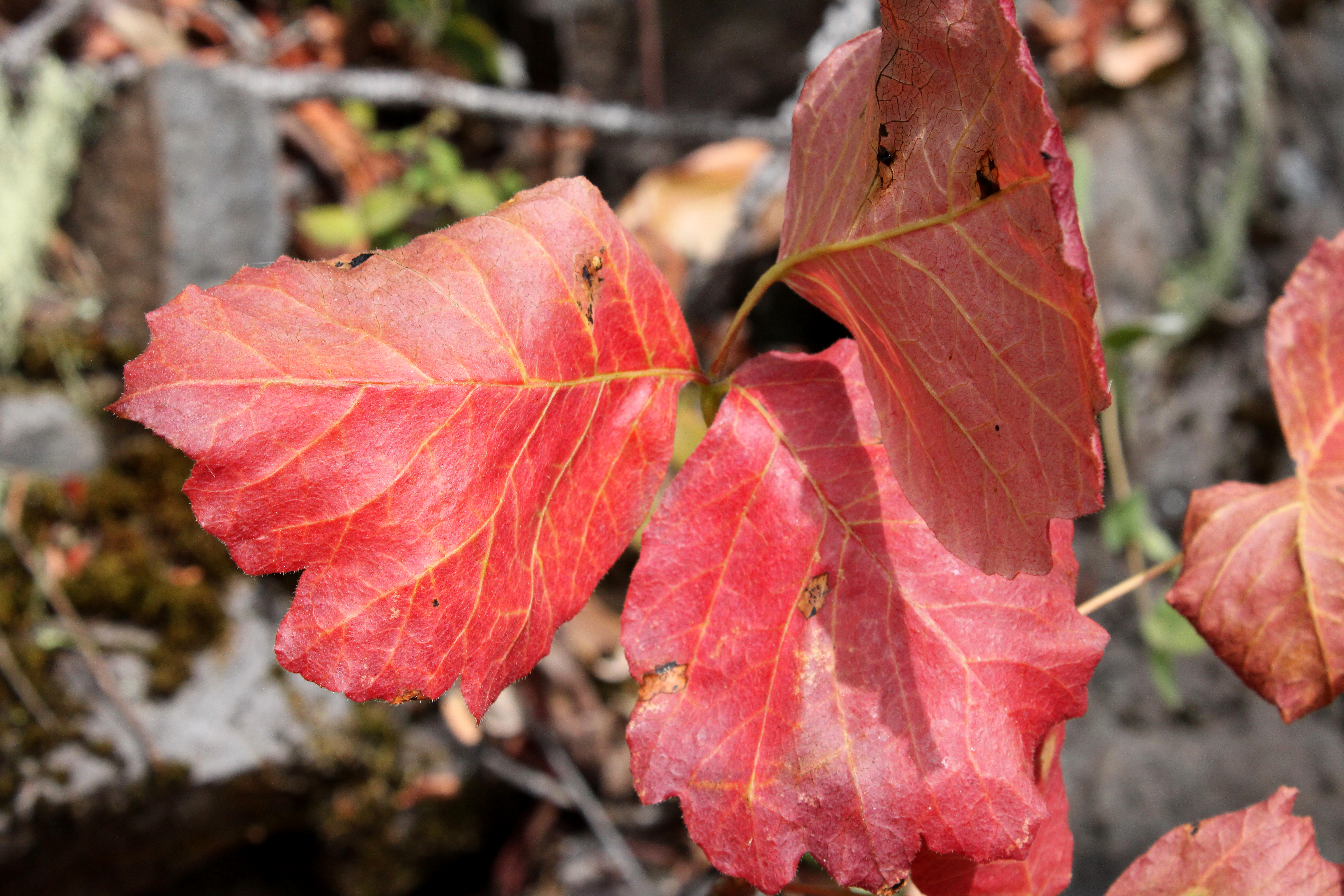
So, it was back the way I came, all the way back to the picnic area at Susan Creek. The hike had been an easy 5 miles, so I added a walk to Susan Creek Campground and back for a more worthy distance. The trail to the campground was mostly lush and green, although the woods by the campground had also been burned. In the open sunlight, scarlet poison oak leaves advertised the presence of that accursed plant. Below the path, the North Umpqua River sparkled in the afternoon sun and I couldn't escape noticing thousands of acres of dead trees on the other side of the river, extending all the way up into the surrounding mountains.

Ferns from the Shadow Realm

I've often said there is beauty in a burn zone and I'm really trying hard to love this section of the North Umpqua Trail all over again. But damn, it used to be so beautiful before Archie's sacking and pillage of the once and former live forest. I'll keep working on my attitude, though.

Katydid did it

For more photos of this hike, please visit the Flickr album

Monday, September 19, 2022

Upper Rogue River Trail (Crater Rim Trailhead)


Rough Rider Falls is like the hiking version of Moby Dick. Ever elusive, the cascade remains an obsessive quest for me and if I don't ever get there, it won't be for lack of trying. Maybe my new trail name should be Captain Ahab. Although, I prefer to think of the unobtainable waterfall as the hiking equivalent of the Holy Grail, if only because Sir Galahad is a much cooler trail name than Captain Ahab. At any rate, my Rough Rider Falls saga continued with yet another attempt to get there.

Wet from the morning rain

Faithful readers (all three of you) will recall that on two previous occasions I had tried to hike to the falls on the Upper Rogue River Trail (URRT) via Hamaker Trailhead. The same readers will also note that the attempts both failed when huge piles of fallen trees blocked further progress along the trail. So, why not try it from the upper end of the URRT? What could ever go wrong?

Pretty much all the 10 mile hike was like this

Missy, Terry, and I set out from the Crater Rim Trailhead with a cheery "Call me Ishmael". That only makes sense if you've read "Moby Dick", which might explain the puzzled looks received from my two companions. This area had been totally charred in the 2015 Crescent Fire, and a new forest is sprouting below the acres and acres (and even more acres) of dead lodgepole pine trees. This hike would be all about hiking in a burn zone in both a good and bad way.

Fortunately, we didn't have to dodge lightning bolts

The Crescent Fire had been set alight by a lightning storm and coincidentally, there was a chance of lightning in the current forecast. The day was dark and cloudy, but electric death rays from the sky never materialized and while we did get a few drops of rain, the day went sunny at one juncture too. At any rate, we hiked on a wildly spectacular cloud day.

The massive canyon of the Upper Rogue

Just a few miles removed from its inception at Boundary Springs, the Rogue River flowed below the trail. The soil here is all pumice and soft volcanic ash, delivered no doubt when Mount Mazama experienced the cataclysmic eruption that created Crater Lake. Soft soil is no match for persistent running water, and consequently, the river has carved out an incredibly deep gorge north of Crater Lake. Since there was no more forest to clutter up the view, thanks to the Crescent Fire, we enjoyed constant views of the massive canyon.

Cottonwood Creek's canyon rivaled the Rogue's in size

We were basically following the gorge's rim but at one point the trail peeled away from the rim and commenced a rather lengthy detour around Cascade Creek. Soft volcanic soils are no match for persistent creeks either, and Cascade Creek had carved out its own gorge, rivaling the Rogue's in deepness and size, yet totally incommensurate with the creek's small water flow.

Hiking on an increasingly sketchy trail

The farther we hiked from the junction with the Boundary Springs Trail, the sketchier the path became. Fallen trees were strewn about, and the hike became all about getting over, under, or around them. No trees means increased sunlight, which means increased vegetation, which in turn means a disappearing trail. However, the Siskiyou Mountain Club had cleared this trail several years ago and we navigated by looking for log cuts and stumps left over from their handiwork. If we couldn't find those signs, then we just simply walked along the rim until we did.

The trail disappeared from view at times

We did find the trail going down into the canyon, but it was in poor shape. Besides the obligatory fallen trees and encroaching vegetation, we had to contend with scrabbling across a couple of small landslides. When we reached the bottom of the canyon, a short confab was convened where I consulted with my GPS to see where we were in relation to the falls.

Down in the Rogue's canyon

Things I learned about GPSs and online maps because of this hike: If you switch to street map to topographical to terrain view, objects (like Rough Rider Falls) can appear and disappear. The same thing can occur if you zoom in or out. The practical application of all this took place on the trail when I could not locate Rough Rider Falls on my GPS (because I had zoomed in). I could see an unnamed waterfall upstream of us but getting there was impossible because of the amount of fire debris and downfall clogging up the river canyon. As it turned out in hindsight, the falls were only about a third of a mile on the trail ahead of us. So close! 

Bushwhacking, if you overlook the lack of bushes

Believing that we could not get to Roughrider Falls, we turned around and headed back through the many miles of dead trees. At Cascade Creek. Missy suggested we go cross-country to the URRT and that sounded fun so off we went. I hesitate to call it a bushwhack because that would imply bushes, and there really weren't any. Also, it wasn't like there was that much difference between our overland route and the trail anyway.

Fireweed thrived in the burn area

So, the URRT is where hiking dreams go to die. But not completely, though. A friend of mine did reach the falls by starting at milepost 115 on the nearby highway, and then bushwhacking to the trail.  Armed with this knowledge, I can already envision a fourth attempt to capture my great white whale of a hike. Aargh, just call me Captain Ahab.

This was the closest we got to the Rogue River

For more photos of this hike, please visit the Flickr album.

Saturday, September 17, 2022

Fish Lake


Back in 2004, I first hiked along Fish Lake Creek to Fish Lake via the Fish Lake Trail. It had been two years after the Tiller Complex Fire(s) had swept through the area, completely immolating the forest all along the trail, leaving behind an obstacle course of blackened and fallen trees to hike over, under, and around. For me, it has always been interesting to come hike here and observe the forest gradually heal itself after the fire.

Site of the 2002 Tiller Complex Fire

I'm not sure what happened to the piles of trees laying on the trail in 2004, for there is very little sign of the fire damage from twenty years ago. Presumably, they decomposed into the earth, but sheesh, there was about two solid miles of them! At any rate, the only tangible sign of the 2002 fire is a stand of dead trees high on a ridge, bleached by the sun, with new starts taking root beneath the bones of their still standing (but very dead) ancestors. 

Working our way over a woodpile

And speaking of ancient denizens of the forest, the Friends of the Umpqua hiked to Fish Lake on a late summer day. There had been subsequent fires in the area since the 2002 burn and we still had to negotiate our way past individual fallen trees and one rather large and formidable collection of them numbering maybe a dozen. Depending on the preference of individual hikers, we either scrambled over or bushwhacked around. Either way, it was work and tedium.

Queen Anne's Lace zealously
hoards this year's crop of seeds

It was technically summer but not for long. On the day of the hike, the temperature was autumnally cool and the sky overcast, in a clear harbinger of the coming fall season. Thimbleberry leaves were already turning yellow while dried seed heads of Queen Anne's lace were knotted up like so many bony arthritic fists. But it was poison oak that was all in for autumn, their bright red leaves serving as a warning flag to bare-legged hikers hiking in shorts.

The worms are gone but their tents remain

Another sign of autumn were the webby tents of fall webworms, a caterpillar that en masse, defoliates madrone trees and creates web nests on the branches for protection. The caterpillars had already left the nests to pupate but their webs remained on leafless madrone branches for hikers to look at and poke. An odd little factoid is that the caterpillars are social eaters, leaving the nest during the day to forage together in creepy-crawly companionship. Often seen heading to higher branches in large groups, they literally are true social climbers, minus the traits of overtly obsequious sycophants we all know and don't love.

Mike checks out the tall cliff

The trail initially followed Fish Lake Creek but about a mile into the hike, the path peeled away from the stream and headed uphill, inscribing a route around the headwaters of an unnamed side creek. Points of interest along the way were a massive cliff looming over the trail, the aforementioned dead forest from the 2002 fire, and an overlook of Fish Lake Creek's impressive canyon.

Beaver Swamp

Beaver Swamp is a marshy little pond that the trail fishhooks around. Often, turtles are spotted sunning themselves on mossy logs, but not on this overcast day. The waters were quiet, seemingly devoid of animal life, although there were game paths visible in the marsh grasses surrounding the swamp. The picturesque quality of the bucolic marsh almost made us forget we were hiking uphill as we hiked up and around.

Trail through a forest not yet touched by fire

The trail quickly climbed away from Beaver Swamp and entered a forest that was notable because it was the first forest on the day that had not yet been touched by fire, knock on live wood. The undergrowth was vibrant and moss covered most inanimate objects, present company excepted. The trees sported leaves and needles and it was almost jarring to see so much green color and hue after spending several miles and hours in burn zones old and new.

The tip of Highrock Mountain looms from up on high

The reason you slog uphill for four miles is Fish Lake itself. Ringed by mountains and forest, the large alpine lake is a most worthy destination. The massive wall of Rocky Rim, a meritorious hike in its own right, loomed at the other end of the lake. However, craggy Highrock Mountain commanded our attention, lording over the scene like a king's castle proudly surveying its domain. We were but mere vassals in the presence of such majesty, although we stopped just short of groveling at the mountain's feet.

Fish Lake, seen from the wrong side of its outlet

Missy had heard about a really cool campsite on the other side of the Fish Lake's outlet, so we walked across on the logs piled up at the creek's egress from the lake. And speaking of which, Fish Lake is the source of Fish Lake Creek and what were the odds of that amazing coincidence ever happening? At any rate, we did not find a really cool campsite but were nonetheless rewarded with a magnificent view of the lake reposing beneath its mountain friends and neighbors.

A gift for the birthday girl

At Fish Lake, while we lunched, we did engage in a bit of hijinkery. It was Missy's birthday and we all donned tin-foil cone hats and sang "Happy Birthday" before doing the four-mile downhill hike to the trailhead. At the trailhead, I caught a baby western racer snake and offered it to Missy as a birthday present. She politely declined, the snake crapped my hand, and those two things may be related.

Poison oak was easy to spot with its red leaves

For more photos of this hike, please visit the Flickr album.

Monday, September 12, 2022

Upper Rogue River (Hamaker Meadow)


I was cruising through the Internet the other evening and came across a boastful blurb stating the Siskiyou Mountain Club had cleared the Upper Rogue River Trail (URRT) to Rough Rider Falls. Whoops of joy then filled the exalted air of my man cave, for several years ago I had tried to hike to the cascade but had been thoroughly repelled by tonnages of fallen trees laying across the trail. As an added degree of excitement on that particular hike, I also had a close encounter with a mama bear and her two cubs when returning from said piles of fallen trees. Rough Rider Falls wasn't very user-friendly to me that day but since the trail allegedly had been cleared of piles of fallen trees (and hopefully of bears, too), it was time for another attempt to reach the ever so elusive Rough Rider Falls. 

Just beautiful weather for hiking in

It was a perfect day for hiking this more recent time out. The sun made an appearance but the temperature remained mild, part of a recent cool-weather trend that was hopefully aiding and abetting the fire crews doing battle with the Cedar Creek Fire. That in turn, might also hopefully ease the smoke befouling the air in the McKenzie and Umpqua Valleys. At any rate, I was happy to be out hiking in cooler weather.

Got plenty of quality forest time in

Beginning from the trailhead, the path wandered north on an up and down route next to the Rogue River. Sometimes above the river on a forested bench, sometimes down in the riverside brush, the trail clearly could not make up its mind as whether to stay high or low. My legs appreciated the mild exercise though, as the ups were not all that challenging or daunting.

The river is amazingly clear

When the trail ambled down by the river, the water was remarkably clear, which stood to reason seeing as how we (my imaginary friend and I) were only about five miles from Boundary Springs, the fountainhead of the mighty Rogue. Occasionally, green meadows were spotted on the other side of the river. I say occasionally, for the brush and forest really made it hard to see down to the river in the first place, much less to any surrounding landscape or meadows.

No-Name Falls labors in anonymity 

About a mile into the hike, a roar emanating from the river announced the presence of No-Name Falls. Officially, the cascade does not have a name but is referred to by regulars as No-Name Falls, which is almost like a name. I scrambled down to the cascade for a better look and spent a few minutes simply appreciating the sight and might of the Rogue River rumbling and tumbling down the cascade's narrow chute.

At times, the trail went sketchy on me

Despite the claim that the trail had been maintained, signs of trail love were in short supply. The track was littered with small branches and storm debris and where the vegetative growth was vigorous and robust, the trail was faint and a little hard to follow, especially where knee-high bracken fern encroached the trail. Unless an intervention soon occurs, the ferns will win out and claim the trail wholly for themselves.

Time to admit defeat, again

Just short of three miles of hiking fun, a large tree lay across the trail. I swear it was the same tree from when I had hiked this trail several years ago. And sure enough, then there was another fallen tree sprawling on the trail much like an somnolent guest at a Nyquil convention. And then there was another fallen tree, and another, and another, etc. I literally crawled under or over the first eight or ten to get by but when a large Empire State Building of logs blocked further progress north, it was deja vu all over again. 

Sunlight slants through the forest in the afternoon

Soundly defeated, it was a turnaround hike back to the trailhead where I then crossed Forest Road 6530 and picked up the resumption of the Upper Rogue River Trail heading south. This section of the URRT had its tree issues too, but there were none as formidable as the daunting piles blocking the way to Roughrider Falls, and I was able to make acceptable progress along the trail.

A brief glimpse of very large Hamaker Meadows

Basically, the route contoured along the edge of massive Hamaker Meadows, although it was hard to tell as the path stayed in mostly viewless forest above the meadows. Periodic openings in the forest provided brief peeks at the grassy expanse below and on one occasion, I bushwhacked down into the meadows proper. It didn't take long for boots to start sinking into the boggy soil so I didn't get all that far into the scenic greenery reposing below forested Hamaker Butte. After a mile and a half contouring above Hamaker Meadows, the trail crossed the river on a stout footbridge at Hamaker Camp and that was my cue to turn around and leave all things Hamaker behind.

The Rogue kept me company throughout the day

Even when you don't reach your destination, it's still a good hike and this venture was no exception. I got to spend all day in beautiful forest with a clear-running river flowing below the trail and there's nothing wrong with that at all, especially when there's no scary bear encounter involved. However, Roughrider Falls still remains as elusive as ever and my next plan to get there will involve hiking the Upper Rogue River Trail from the Crater Rim Trailhead. We'll see if I'll be more successful or not.

Hamaker Meadows, from Hamaker Camp

For more photos of this hike, please visit the Flickr album.

Saturday, September 10, 2022

Lola Lake Loop (Oregon Coast Trail)


Because Facebook knows everything about me, on my feed I received a blurb about a coastal birding club (it may have been the Audubon Society) going on a short 2.5 mile nature walk around Lola Lake, located somewhere on the coast near Pistol River. They may have even called it a hike. Anyway, I'm all like "Birds? Meh!" followed by "NEW TRAIL!!!" After a short investigatory consult with the Internet, I ascertained that it was possible to reach the beach from Lola Lake, and thereby accrue a more proper hike mileage by walking north to the mouth of the Pistol River. A
t that point, I was all in.

You need to keep an eye out for this guy to find the trailhead

The trailhead was not that easy to find, and I initially drove past without realizing it. Coming back the other way, though, a post with a blue Oregon Coast Trail marker affixed to it was clearly visible by the side of the roadway and in short order, I found myself hurriedly lacing up my boots at the trailhead, eager to get started.

A well-maintained path wanders through the forest

The Oregon Coast Trail quickly left the busy highway behind, dipping into a typical lush and shady coastal forest. My initial impression was how nicely maintained the trail was. The brush had been cut back from the trail, there were no fallen trees to step over, and clearly legible and informative signs were posted at every intersection. I'm so not used to this!

Wintergreen was clearly in blooming season

The first intersection offered the choice of hiking to the beach or looping around Lola Lake. Since I'd never been, Lola Lake it was. The forest on the loop trail was heavily mossed and a healthy population of ankle-high wintergreen was busy flowering on the forest floor, enthusiastically hoisting aloft stalks of white flowers like so many football fans waving their pennants. Mushrooms, ferns, and moss likewise abounded, feasting on the decaying biomass so prevalent in a coastal forest.

Lola Lake in all its grassy glory

If Lola Lake were to be the sole reason for this hike, then I'd be bitterly disappointed. The lake had dried up and gone to meadow. Presumably, the lake is actually a lake when the spring rains fall but this late in summer, there wasn't any water. That wasn't a deal-breaker though, for the erstwhile lake still was a nice meadow and there's no complaining when you hike to a brand new place anyway.

The trail begins to transition from woods to dunes

After executing the lake loop, it was then a right turn onto the beach trail which continued the wander through dense coastal woods. Eventually though, the dirt path became a sandy track and the trees thinned out, giving way to beachgrass and dunes. Common yarrow and pearly everlasting were in bloom among the omnipresent beachgrass, the wildflowers busily entertaining bees, butterflies, small wasps, and incredibly handsome hikers-cum-photographers.

View to distant Cape Sebastian

Odd and totally out of place amid the sand and beachgrass was a large castle-like rock formation. The rock was adorned with striations and layers of tan and ocher hues and tints. A short scramble to the tip of the rock yielded a view to distant Cape Sebastian so I had to stop for a bit and do some photography before continuing on.

Sand Creek snakes across the sand

The trail reached the beach just north of Crook Point, whose rocks and islands are an effective deterrent to hiking further south via beach. Sand Creek snaked out of the grassy dunes to sassily sashay across the beach to become one with the ocean. The surf crashing onto the craggy rocks of the scenic point entertained and to the north, stretched a long beach with Cape Sebastian looming many miles beyond.

View to the north

I never made it to Pistol River like I had intended. Unfortunately, the wind could be best characterized as belligerent, bellicose, and brawly. I'd venture to guess that I was getting cuffed about by a steady 40 miles-per-hour blow. The stiff breeze peeled spindrifts off the incoming waves and I felt fortunate it was blowing at my back. However, at some point on the return, I'd be hiking into it, my incredibly handsome face bearing the brunt of the wind-driven sand. The question was whether I wanted to endure Mother Nature's free dermabrasion and exfoliation treatment for 2.5 miles, 1 mile, or some distance in between. I eventually chose to turn around after a mere mile of beach walking.

An incoming wave wants to eat me

As anticipated, it was a stinging and bracing walk back to Crook Point with eyes all teary, but on the plus side, I don't have acne anymore if only because you can't have acne without having facial skin. Needless to say, it was much appreciated when the trail left the beach and entered the sheltering woods.

Low growing fleabane prettified the sand dunes

I really didn't any pay attention to any birds on his hike. In fact, I'm not even sure there were any birds for me to pay attention to. However, I'm nonetheless grateful to the birds for exciting the birding crowd to the point they put on the hike I had mentioned earlier. My first visit to this particular section of the Oregon coast would not have happened without the birds and birders. Happy squawks, chirps, and keening cries to all concerned.

Islands near Crook Point

For more photos of this hike, please visit the Flickr album.