Saturday, February 27, 2016

Bandon Beach to New River

Well, this hike got certainly got off to a mysterious start! From the parking lot at Face Rock Viewpoint, we had a nice overlook of the beach below. The sand was adorned with an elaborate crop circle labyrinth and people with long beards (some of whom were men) talked about Ley lines and sacred places. Most onlookers simply admired the artwork and walked the maze. I didn't because I always get lost in those things.

Happy!
It's hard to get lost hiking from Bandon Beach to the New River, though: just keep the ocean on the right and Oregon on the left until a large river blocks the way. Leaving the tie-dye crowd behind at the labyrinth, we headed south past the rocks and islands that make Bandon Beach such a spectacularly scenic place. After splashing across Johnson Creek, Haystack Rock loomed ahead in the misty haze and we pretty much had the Oregon coast all to ourselves at that point.

Not happy!
Speaking of splashing across creeks, Wish and Daisy (our two dog companions) were having the time of their lives and we should all cross creeks as happy as a dog. We wound up wading across creeks 6 times on this hike as we had to cross Johnson, Crooked, and China Creeks two times each. I don't think the 7 of us in our group enjoyed the wading nearly as much as the dogs did.

Sneaker wave just snuck up on us
And now, let us talk about sneaker waves. Sneaker waves are sneaky, alright. They look like normal waves but the difference between a sneaker wave and a regular wave is that a sneaker wave simply keeps on coming. So there we were, walking around a large rock with at least 50 yards of beach to work with when a wave just kept rolling in, and rather quickly too. So we ran to the rock but alas, there was nothing to stand upon. Pinned to the rock wall, we had the endure the indignity of standing knee deep in salty water, although the dogs thought the whole episode more fun than a yard full of cats. Later on in the hike, another wave chased us up the beach where we had to frantically hop on logs to avoid the onrushing water.

The New River
Once we left prominent Haystack Rock behind, it was basically a couple miles of sandy beach walking until we arrived at the mouth of the New River. I had backpacked here last summer and the New River was then all dried up, never quite making it to the ocean. However, on this late winter day it was flowing fast and wide due to all the recent rain. There was one lone hiker on the dunes overlooking the river and it turned out to be our friend Don from the South Coast Striders hiking club.

Not a lot of beach to walk on
We ate lunch next to the New River while some of us did a brief barefoot exploration of Twomile Creek. The return track to Bandon was then all about the high tide and we performed many a sprint to higher ground as the sneaker waves were less sneaky and as brazen as a pack of wild monkeys. We basically had only the driftwood-littered top ten yards of beach to hike in.


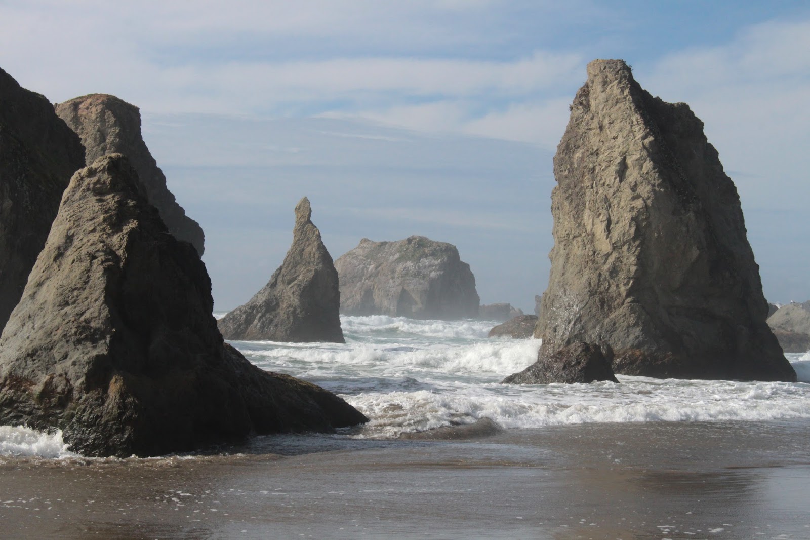
Why Bandon Beach is totally awesome
As we neared the rock islands at Bandon Beach, I opted to go around the front of a large rock while everybody else went around the back. It was the same rock involved with the sneaker wave on the way in and you'd think I would learn. I watched the waves and when they retreated, I sprinted around the front, timing my mad dash perfectly. The problem was that I was looking over my shoulder at the waves and did not notice the 6-foot deep puddle in front of me until I plunged waist deep into the cold water. Panicked, because the surf was now coming in, I charged through only to find a subsequent second swimming pool in the beach. Totally soaked from the waist down, I rejoined up with Kevin, who thought the whole episode to be hysterically funny.

High tide was the story on the return leg
By the time we arrived at the trail off the beach, the waves had erased the elaborate labyrinth we had so enjoyed at the start of the hike. It only goes to show that beach art will always be transient and ephemeral in nature. As we prepared to begin the long ride home, Rachel (who resides in nearby Coos Bay) taunted us with "I'll be home in half an hour" To which (retired) Lindsay replied "Yes, but what will you be doing Monday?" Game, set, and match to Lindsay!
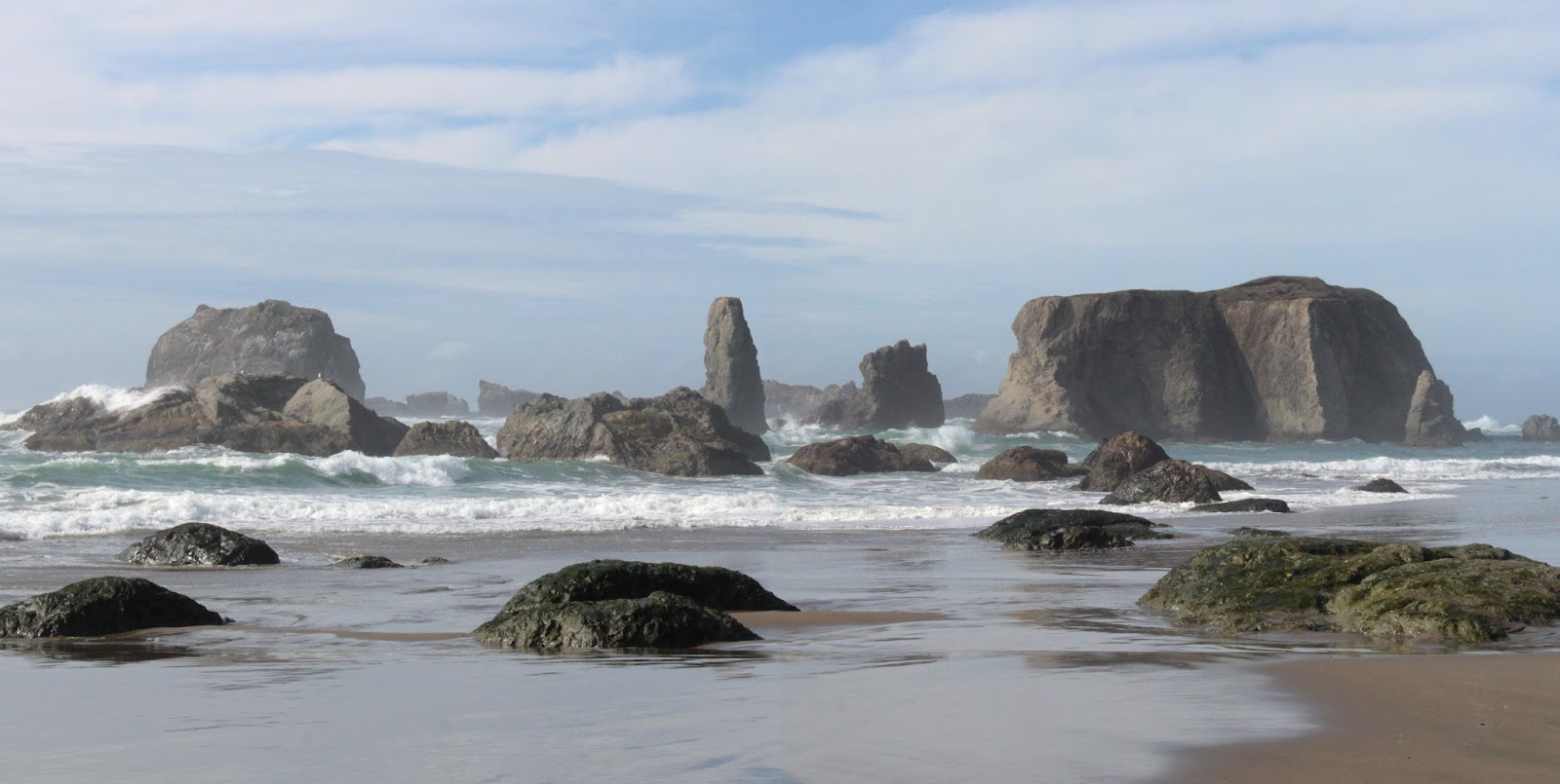
Bandon Beach
For more pictures of this hike, please visit the Flickr album.

Thursday, February 18, 2016

Turnbull Wildlife Refuge

Daughter Jessie was getting married so naturally I instead went hiking. Kidding! Actually Dollie and I drove up to Spokane for the very special event which I actually attended. However, the days before the wedding did provide me at least one opportunity to slip away for a mental-health hike on a crisp day that hovered somewhere between winter and spring.

Let the mosquito breeding begin!
The hike of choice was Turnbull Wildlife Refuge as it was a reliable snow-free destination in an area surrounded by mountains covered with snow. At the start, the day was overcast and it felt like it just might rain. However, I cared less about the rain and more about the brisk and biting wind blowing through my layers of clothing. So with a rueful "Dang, it's cold", I set out on the trail, leaving the rustic buildings of the refuge headquarters behind.

Windmill Pond


The double track trail (another term for gravel road) led to marshy Windmill Pond where a small boardwalk provided a view of the tranquil waters. Small birds twittered in the bushes and that was it for any wildlife sighting at Windmill Pond. Because I was wandering aimlessly in an area I was not familiar with, I continued on the first gravel road I saw, which promptly headed up a rolling hill forested with Ponderosa pine.


The loneliness
After a half-mile or so, the road broke out of the forest and an endless prairie of short grass stretched out in front of me. All that wind was working hard at blowing the clouds away and I actually got to enjoy blue sky and bright sun off and on for the rest of the day. It still was cold though. Below the trail reposed the bright blue waters of Middle Pine Lake, surrounded by a bowl of dried brown grass. An intersection with the Stubblefield Trail called to me because it probably had stubble and a field on it.

Blue sky on a winter day
Despite the relatively flat and seemingly dry terrain, there was standing water everywhere. Flanking the trail were ponds and puddles of all sizes and shapes, which no doubt attract migrating birds in birding season. A pamphlet obtained at the headquarters mentioned moose but on this day I was virtually the only wildlife out on the sparse and treeless steppe.


This way to the Mississippi!
This was a great cloud day as clouds formed and reformed overhead, making for slow going as I chronicled each and every atmospheric change with my camera. The trail was unrelentingly straight and I felt if I would keep hiking on it, I'd wind up on the banks of the Mississippi River at some point. The terrain was basically flat but there were a lot of  gentle rolling ups and downs with each little depression containing a body of water sparkling in the intermittent sun.

The Washington State Tree
At about the 2.5 mile mark, Stubblefield Lake came into view, appropriately surrounded by stubble and fields. Ducks, in a rare wildlife sighting, flew away in feathered panic at my arrival. There was actually one tree at the lake so I had to take a picture of it. It was just the perfect place to sit down, shivering in the brisk breeze, and contemplate the stark beauty of the panorama before me.

Not the "Long and Winding Road"
At Stubblefield Lake, another road followed a fence line back towards the refuge headquarters and that was my return route. More clouds, more blue sky, more grass, and more lakes were my source of both entertainment and mental health therapy as I walked. Just a grand, albeit chilly, day in eastern Washington.


Cheever Lake
Cheever Lake is the largest of the Pine Lakes and I took a short side trip to visit the blue lake. A bald eagle was patrolling the sky above the lake but never got close enough for me to get a picture of it. The trail to the lake continued on but totally in the wrong direction so I backtracked and took a left turn on the trail back to the Pine Lakes.


Paved trail next to Middle Pine Lake
This is a wildlife refuge and signs admonished me to stay on trail as the grasslands next to Cheever Lake were are reserved for birds only. I sure hope the moose can read those signs! At Middle Pine Lake, I grabbed a trail that wandered on the opposite side of the lake and a family of trumpeter swans regally paddled away from me. The trail was civilized and totally paved as it wandered past the maze of water channels at the lake's inlet.

Storm blowing in at the end of the hike
Timed it just right because a noticeable storm was blowing in from the south and I made it back to the trailhead just as the rain started. All in all it was a good hike that left me mentally fortified for the next round of wedding preparations.

Joy
For more pictures of this hike, please visit the Flickr album.


Sunday, February 14, 2016

Rainie Falls

The Rainie Falls Trail is like Cinderella to the rich stepsister that is the Rogue River Trail. The Rogue River Trail is an epic 39 mile backpack trip from end to end while the Rainie Falls Trail logs in at a paltry 2.4 miles. The Rogue River Trail is fairly well maintained while the Rainie Falls Trail is somewhat on the rough-hewn and rustic side. Despite their differences though, both trails have a lot of similarities: a lot of happy cliff time, grand views of the Rogue, forests comprised of oak, laurel and orange-trunked madrone; and all the poison oak you could ever want to hike through. The one thing that the Rainie Falls Trail does offer that the Rogue River Trail does not, is a nice up close and personal view of Rainie Falls. For all its epicness, the Rogue River Trail only lets you hear but not see the falls. Also on the plus side, the comparitive shortness of the hike makes Rainie Falls a more grandchild-friendly day hike venture, no sense taking  them out on the 39 mile day hike just yet.

Rainy view from the Rainie Falls Trail
It was a rainy day so this would be a rainy Rainie hike for me and grandchildren Aiden and Coral Rae. The trail wasted no time getting high up on the cliffs above the rain-swollen river. The noisy roar of the Rogue coursing through Grave Creek Rapids was an aural backdrop to the steady staccato of raindrops striking fragrant laurel leaves. Moss covered everything except for the trunks of madrone trees whose smooth moss-free trunks glowed orange like someone who spent too much time in the tanning bed. 

Anjuli: do not read this blog


The trail is crudely hacked into the side of the cliffs flanking the river and the tread was fairly rough. The rocks were wet and slippery and just the perfect place to take young children hiking! Aiden was nervous, not about the height or the exposure of the trail, but about his younger sister getting too close to the edge. Since Coral Rae had two nervous companions admonishing and policing her, she had a safe and enjoyable hike and hopefully their mother will not read this blog or see the photos of her precious children on a wet and cliffy trail.

Narrow trail, perfect for taking young kids on!
The trail spent a lot of time underneath laurel trees and the kids were intrigued by the odor of the leaves. I mentioned that you could chew the leaves for a stronger taste of laurel and just a few seconds later, we were all munching on leaves like a herd of herbivores. Aiden spit his out, crying that the leaves burned his lips and he was sure that I had poisoned him. He spent the remainder of the trip assessing his health and checking for symptoms of laurel toxicity. He needs to get outdoors more, I think.

Cloaked in mystery
Periodic "windows" in the forest provided great views of the Rogue River snaking its way through its canyon. From the river to the top of the canyon, it's nearly 3,000 feet of elevation gain but most of the canyon's upper reaches were hidden by misty clouds trailing feathery tendrils of rain. And at just over the two mile mark, we reached Rainie Falls.


Not Niagara Falls
Rainie Falls are not very tall, being only about 10 feet high. In fact a group of hikers arrived after us and they asked me if this was Rainie Falls. When I said "yes", disappointment was etched on their faces. "I guess I was expecting Niagara Falls" opined one male hiker. However, while Rainie Falls are not very tall, the falls are all about volume as the entire Rogue River tumbles over the noisy cascade. I imagine that Rainie Falls might just appear to be Niagara Falls to rafters and kayakers on the precipice of the thundering plunge.

Get away from the edge, you'll
give your brother a heart attack!
The rain abated as we ate lunch next to the falls and we found out Coral Rae does not like sardines as she urped up a wad of chewed up sardine goo onto her hiking boots. Good thing I brought extra crackers. After lunch and boot cleanup, we headed back the way we came. The kids were a little tired and did not scamper as much as they did on the way in. Because of the slower walking, we were all a little more observant as I found some blooming saxifrage and snow queen (spring is coming, yippee-ki-yay!). Coral Rae became quite adept at spotting Roth's forest snails on tree branches. And Aiden still was quite adept at yelling at Coral Rae to get away from the edge, forest snails notwithstanding.

Orange, wet, and smooth, just like me!
A good time was had by all and for more pictures of this hike, please visit the Flickr album.

Snow queen


Saturday, February 13, 2016

Bastendorff Bog Trail

I've hiked in the Cape Arago area for what seems like a million times. Despite being overly familiar, the cape is one of my favorite places and is always spectacular; be it at night, in the fog, in a torrential downpour, or on a sunny day. Unfortunately, the relatively small state parks in the area don't offer much options for hiking other than the spectacular trail along the coast. However, thanks to the South Coast Striders, a Coos Bay hiking group, I've had my horizons broadened as they've exposed me to the Perimeter Trail and now, the Bastendorff Bog Trail.

The forest needs no "sprucing" up!


The Bastendorff Bog Trail is a mile'ish long path that runs from Sunset Bay Campground to Cape Arago Highway near Yoakam Point. I've driven by the trail many times but unless you know where it is, you'd never know it was there; it's like the ninja night assassin of trails. Although the Bastendorff Bog Trail officially ends at the highway, a loose network of use-trails on the other side takes hikers to various viewpoints and beaches on and below Yoakam Point and is the answer to the age-old question "why did the hiker cross the road?"


Skunk cabbage
Approximately 30 hikers took the green flag and began ambling through Sunset Bay Campground, exchanging morning greetings with campers rubbing the smoke and sleep out of their eyes around their respective campfires. The trail officially began in the hiker and biker camp which somehow seemed appropriate enough. On a slippery footbridge, we crossed Big Creek's muddy bog replete with blooming odiferous skunk cabbage, and then began a short but brisk charge uphill through lush coastal forest.

On the Bastendorff Bog Trail
After a half mile or so on a trail flanked with dense salal and coastal huckleberry bushes waving green fronds over the trail, a loosely defined Bastendorff Bog made an appearance on the right side of the trail. Apparently, the bog is home to a population of rare and endangered western bog lily; the showy blooms would make spring a good time for a return visit. However, in February, there was not a lot going on in the bog.

A big lump of coal for Christmas
Past the bog, the trail spit us out onto Cape Arago Highway from the aforementioned hidden trailhead after a mile or so. But no worries, the hike hadn't ended yet. Across the busy highway was that collection of rough paths that wander the forested bench of Yoakam Point. Mild bushwhacking yielded intermittent open areas in the forest with the open areas providing views of the rugged Oregon coast and Cape Arago Lighthouse perched atop Gregory Point (actually an island). Below the point, an exposed seam of coal flashed back to the time when Coos Bay actually had a coal industry,

View from Yoakam Point
The actual point of  Yoakam Point is narrow and exposed and there was not room enough for 30 plus hikers on it, although we did try. In the end, we took turns and cameras were kept busy on the point. The view north was stunning as mile-long Bastendorff Beach curved gracefully before dead-ending at Coos Bay's south jetty. Directly below, waves crashed upon exposed rocky reefs and crags. Way cool.


Whee!
And then the fun started! The route led from the top of Yoakam Point down to a sheltered cove immediately below by means of a rope descent on a treacherously muddy track that even mountain goats would find too dangerous. Some of us more sure-footed hikers aided the less nimble on the way down and I'm glad to report I saw only one hiker rolling down the trail with the sole injury being that of a sprained dignity. The patient is expected to recover. It is also worthy to note that the hike organizers gave no hint of this descent until the very moment it was time to descend, thereby neatly avoiding a pre-descent mutiny.


Temporary respite after the descent
So, 30 plus hikers were milling around on the secluded and sandy cove, grateful to be done with the muddy drop, when we were informed that we now had to scramble up and over a rocky point to get to Bastendorff Beach. It was then that the phrase "kill the hike leader" was first muttered. Options were limited if one did not want to risk that scramble because the only way back was by means of a rope ascent up a treacherous muddy track that even mountain goats would find dangerous. For me, this was like being on a Richard Hike but with none of the criminal liability.


And it's not even a Richard Hike!
The scramble up and over the point was not particularly tall, but the rocks were covered with slimy green seaweed that had us yearning for a treacherously muddy track instead. But again, with help from the sure-footed, all hikers made it safely over with no injuries to dignity or any body parts. And now, it was a simple mile-plus beach walk along Bastendorff Beach until we reached the south jetty.


Incoming!
While some ate lunch, others scrambled (your merry blogster included) atop the jetty boulders to observe waves marching up Coos Bay's (the bay) entrance, seemingly intent to administer a watery smiting to Coos Bay (the city). The waves were rather robust and after a few close calls atop the jetty we promptly departed lest we receive a watery smiting ourselves.


Rocky shoal near Yoakam Point
Our egress off of Bastendorff Beach was on a rather civilized trail with a footbridge or two. The tameness of the trail raised the question of why we had to make that wild descent in the first place but on the other hand, there simply is no glory in a tame trail. So, in the end,  this 6 miler was a tasty hiking smorgasbord of coastal delights. It was nice to get a new trail experience out of the familiar paths of Cape Arago.

Standing room only on Yoakam Point
For more pictures of this hike, please visit the Flickr album.


Saturday, February 6, 2016

South Santiam River

This was pretty much a fail, as far as hikes go. But it was a qualified fail for the trail was green and mossy while the forest was downright magical. Too bad a rambunctious Elk Creek kept me from hiking more than 2.7 miles. But hey, at least I got a taste of this area and I'll be back with a backpack on for a more protracted acquaintance with the historical Santiam Wagon Road. So, for now, I'll just wax philosophical about the whole short-hike fiasco because the day wasn't a total loss.

Trail marker on the old wagon road
The Santiam Wagon Road first opened for business in 1865 and was the toll road that connected the towns of Sisters and Lebanon. Nowadays, Highway 20 closely follows the route of the Santiam Wagon Road and from Soda Creek east, the historical road has been converted into a long distance hiking and mountain biking trail. Numerous trailheads provide access and a myriad of connecting trails take hikers to other worthy destinations along the canyon of the South Santiam River. Because my guidebook said the trail (at lower elevations) was open all year, I made the 3.5 hour drive to the Mountain House trailhead on a gray and occasionally rainy day.

The South Santiam River


Just after beginning the hike by crossing the South Santiam River on a stout footbridge, a T-intersection provided an unexpected choice as I had thought the trail began here. The trail heading west seemed faint and sketchy while the trail heading east obviously gets more use. East it was, and I turned left and headed up the trail towards House Rock. Up was the key word here and despite the chilly weather I was soon sweating profusely underneath my winter clothing. 

The enchanted forest
The brisk climb had lungs huffing and puffing while leg muscles burned with the sweet agony of walking uphill. However, I cared not a whit because almost immediately the trail entered a forest that was simply magical and enchanting. One halfway expected pixies, leprechauns, or sprites to scamper across the mossy trail. Much photography ensued and made for socially acceptable rest stops.

Moss covers all
The forest here was comprised of thick stands of spindly alder trees, uniformly leafless in the middle of winter. Normally, alder trunks are colored white but these trees were all green and hairy, like last December's lasagna still sitting in a bowl in the refrigerator. Of course, the green "hair" had nothing to do with rotting food but more to do with moss, which claimed everything that wasn't motile. I made sure not to stop for too long, lest I too get claimed!

One of many small creeks crossing the trail
Periodically, small creeks ran across the trail, on their way to join the much larger river in the canyon below. The South Santiam River could be heard but remained mostly unseen due to the lush growth flanking the river. About a mile into the hike, the trail left the alders and entered a more standard Douglas fir forest. Almost immediately, the temperature dropped and it felt that snow just might be a distinct possibility.


Elk Creek
And at the 1.3 mile mark, the trail rounded a bend and Elk Creek was running across the trail. The water was probably about knee-deep or better but was running pretty fast. I could see a doable flat and wading part beginning about halfway across the white water. However, between me and the flat part, the creek was bounding vigorously between boulders. I could not see where it would be safe to cross so after some creekside dithering with my daring and incautious alter ego, I decided to turn back.


I owe you one, Elk Creek!
So, this wound up being a long drive for a short hike. But on the plus side my appetite is stoked for a return visit when Elk Creek will be more manageable. I'm thinking that hiking the Santiam Wagon Road and then going down the McKenzie River Trail might be epic. Stay tuned!


The tree monster reaches for me
For more pictures of this hike, please visit the Flickr album.