Saturday, October 21, 2017

McKenzie River Trail

When I got up in the morning, the rain was just pouring down in sheets, loudly pelting the living room windows and disturbing the cat's sleep. "Watch", I told Dollie "I really don't want to go hiking today but there'll be three morons at the parking lot and I'll have to lead the hike anyway". John was the first to show and he said "Good morning, Richard" and I replied "One moron, two to go" Number two presented arms a few minutes later when Diana arrived. And right on cue, Lane appeared seconds before deadline. "Three morons, I called it", my hostile-sounding remark eliciting a puzzled look from Lane.

The Moron Hiking Club is now called to order
Lane picked up Ceresse in Springfield and after initiating her as an honorary member of the Three-Moron Club, we then headed up the McKenzie Highway, 5 intrepid hikers strong. The original plan was to hike around Clear Lake but I was watching the temperature gauge and it was just a few degrees above freezing. The east side of Clear Lake is all exposed lava fields and the idea of hiking through that in a rain/slush/snow combo just didn't sound very appealing. After a quick roadside confab, we made the impromptu decision to hike on the McKenzie River Trail instead. The thinking was that we'd see the fall colors that make the McKenzie River area so spectacular in October. Plus the thick forest would possibly provide some protection from the rain. 

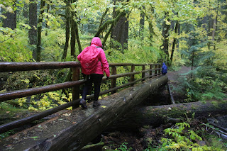
Diana crosses Scott Creek
It was really pouring and it was cold. That about sums it up, weather-wise. The raindrops were heavy and fat, it was like being pelted by ice-cold water balloons without the balloon part. It was so wet that even the salmon stayed indoors. The overhead forest protection delayed the inevitable in that we were soaked within 5 minutes instead of immediately. Ceresse was heard to mutter to Lane about me "Doesn't he know that we could have mall-walked instead?" What, and miss all this?

Soggily spectacular
Rain notwithstanding, the vine maples were out-of-this-world spectacular. The maple growth underneath the tall firs was thick and profuse and all of it was tinted some variation of bright yellow. The day was dark and gloomy, yet the forest seemed to glow with a gold light from within. I'd like to say the fall colors were so spectacular that we forgot all about the cold rain but no, it was so darn wet we could not help but wonder what the heck we were doing out there.  Oddly enough, we never saw another hiker all day, not sure why that was. Come to think of it, we didn't see any mountain bikers, equestrians, or river rafters, either. Not even deer, raccoon, or newt; just us, all alone in the wet woods.

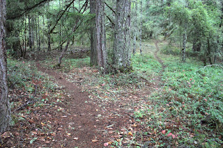
Trail shot


After nearly two miles, we crossed the McKenzie River on a road bridge and the trail was less groomed and more like a real trail. Meaning, the low spots in the trail were full of water and that was where I found out I have worn a hole in my boots. Oh well, at least my feet were wet and cold, didn't want them to miss out on all the watery fun. It was somewhere around here that I removed the camera battery and stored the camera in a waterproof trash bag for safety's sake.

You have to admit, it is an unbelievable display of color
I began to sense waning enthusiasm from my charges, a subtle sign of such was when Diana, Ceresse, and Lane turned back, each telling me in no uncertain terms I am no longer on their Christmas card list. Plus, my phone number has been blocked and they are not answering my text messages. John, though,  was still up for more and I figured he and I could turn around at the intersection with the forest road, winding up with a soggy 6 mile hike. As we continued on, the puddles became deeper and deeper, along with increasing frequency. Eventually, the trail was just one long continuous puddle and my cold wet feet got colder and wetter, if such a thing was possible. After all the spectacularly wet trail miles, it was almost anticlimactic when we turned around at the nondescript gravel road, but at least we got to splash through the puddles all over again on the way back.

Trail through the golden arches


I wound taking just 36 photos, a far cry from the 597 photos I brought home from the Upper Rogue River. I also wound up with 55 pounds of wet day pack, boots, socks, and other assorted clothing, but at least the camera still works. Once inside a dry car with the heater cranked up to full, we all stated that we enjoyed the experience and that we all felt sorry for all the people cooped up in their homes, foolishly staying out of the rain. Yup, we were 5 pretty proud morons!

A river and yellow leaves just about sums it up
For more pictures of this hike, please visit the Flickr album.


Sunday, October 15, 2017

Mildred Kanipe Park

This was one of those days where I felt like hiking but not driving. When I feel so conflicted, well, that's the time to hike local. The day prior, I had such a great hike on the Upper Rogue River that I wanted more, it wasn't enough, and yes, I am a hiking addict. One of these days, I'll be standing in front of my local chapter of H.A. (Hikers Anonymous), confessing "Um...Hi...My name is Richard and I hike a lot..." At any rate, I was not so enthused about spending another half-day of car seat time, so it was time to visit Kanipe Park in nearby Oakland. 

Park security corps
As I parked my car on a drizzly and overcast morn, a pandilla of peacocks came by to accost me, with several hopping on top of my car. "Say, nice paint job there, dude. I'd hate to see some bird crap on your car just because you couldn't see your way to give us some food" I got the message and ponied up a handful of sunflower seeds and my car didn't need a washing afterwards.

Rustic horse barn at the Underwood Home site
There are several loop trails in the park, most being centered around a bridge over muddy Bachelor Creek. I had never hiked in the equestrian area or on the Mildred's Forest Loop so I headed up a gravel road in search of a path to Mildred's Forest. Didn't find one and in short order, I found myself in the nearly empty park campground, wondering "Where'd the trail go?"

Which way do I go?
Quick, consult the phone!
There are many trails that braid across the park acreage and a good map is essential and oops, I didn't bring one. No problem, though, I cheated and popped the map up on my phone and navigated that way. It's not too often I get to hike somewhere with cell phone service. It just goes to show that from a hiking standpoint, cheaters sometimes do prosper!

Think of it as "our" pasture, cows
Anyway, after consulting the phone map, I walked across a pasture, startling a herd of cattle in the process. A wet wade across Bachelor Creek and a short walk on a muddy cow track through the blackberry brambles brought me to the real trail in a thoroughly chewed up field. The bulldozers had been at work here in what presumably was a battle in the war to rid the park of English hawthorn.

Trail through the hawthorns
This area had originally been settled by English pioneers, giving the nearby valley the rather generic name of English Settlement. When they did settle, the English brought English hawthorn with them and Oregon has been trying to export them back ever since. Anyway, Mildred's Forest Trail entered a field full of the thorny invaders before heading uphill to the Drill Barn site.

Oak galls
All that is left of the Drill Barn are the foundation piers in a grassy square in the middle of a young forest. Small oaks were covered in oak galls, and an impenetrable growth of bramble, poison oak, and honeysuckle vines discouraged any off-trail hiking. The trail headed uphill before cresting and closing the loop on a leg through a forest of bigleaf maple and oak. 

Oregon ash provided the only autumn color
After the marvelous autumn display on the Upper Rogue River the day before, I must say I was disappointed in the autumn colors at Kanipe Park. The oaks were still leafed dark green, holding autumn at bay for another couple of weeks. The maples were just starting to blush yellow, so a dispirited "meh!" to them. Occasional Oregon ash trees were in full yellow autumn song but they were few and far between. In all, it was fairly colorless which was appropriate seeing as how the sky was gray too.

It's a jungle out there
The next loop was the Underwood Hill Loop. I had hiked this loop before in the counter-clockwise direction and the uphill climb was brutal, making me think the loop should be named Undertaker Hill instead. However, a clockwise loop is not too bad at all, especially when the gray clouds dissipate and the day morphs from damp and dreary to sunny and cool.

Picturesque trail on Underwood Hill
One of the things I enjoy about Kanipe Park are the acres and acres of some of the most stately and regal oaks you can find in all of Oregon. The trail ambled underneath the majestic trees and the trail was bathed in dappled sunlight as it crested Underwood Hill. Birds twittered and flittered in the branches overhead and blue sky loomed over all. 

Shady glade near Bachelor Creek
Upon returning to the bridge and Bachelor Creek, the next loop of choice was the Fern Woods Trail, colored bright purple on the map. The route paralleled Bachelor Creek before angling gently uphill toward Fern Woods. However, I was distracted by a "shiny object", the distraction being a faint path peeling off the main route and heading up and across a bald and grassy slope. Basically, the path bypassed Fern Woods but served up some Vitamin D restoring sunlight and some nice views of Oakland and the English Settlement valley. 

Kanipe Park is the oak capital of Oregon
As the path descended a ridge festooned with beautiful oak trees, the afternoon sunlight filtered through the trees and shadows lengthened. A picnic table underneath a tree just invited a contemplative sit-down and I obliged. A slow breeze soughed softly through the trees and small songbirds warbled in the surrounding vegetation. There was nary a cloud in sky and best of all, no thieving deer to be seen. Life was good and some serious soul-soothing took place under the oaks as I lazed for a few minutes.

Oak arbor
My route kind of looked like a wobbly clover leaf, but I did get nearly 8.5 miles in. At the day use area, the peacocks came running "He's back! Seed Dude is back!" They did enjoy the remainder of my sunflower seeds and I certainly enjoyed the hike, plus it was a short drive home.

Blackberry considers the arrival of autumn
For more pictures of this hike, please visit the Flickr album.


Saturday, October 14, 2017

Upper Rogue River

My hikes are like my children, I love each one equally. But not really, and I refer to hikes, not to children. Some hikes are so special that they rise to the rank of Most Hallowed Hike instead of being relegated to the nameless and faceless miles of trail that I hike on every year. A good indicator of how much I enjoy a hike can always correlate to how many photos I take. On average, I come back from a hike with 150 to 250 photographs, with the threshold for Most Hallowed Hike status being more than 300 photographs taken. Since I came back from this hike with 597 photos, I may have to come up with another rank above Most Hallowed Hike. After that explanation of photos correlating to favored hikes, my kids will probably start counting photos to see which child I favor over all the others!

Autumn's golden glow
This year, I had visited the Rogue Gorge and Natural Bridge areas a couple of times, but not really hiked them. Either the weather was nasty or we had just eaten mammoth hamburgers at nearby Becki's Restaurant; either way not much hiking was done. However, since this particular day was a cool and sunny autumn marvel and my belly was not stuffed full of hamburger meat and jalapeños, there'd definitely be a hike, with autumn being the star of the trail today.

The first of 597 photographs
Just a quarter of a mile into the hike, I had already snapped off dozens of photographs of vine maple leaves and it was obvious this hike would be all about the fall colors. In Oregon, if you want to see autumnal color glory, then you must go a place (like the Upper Rogue River) where the vine maples grow. The Rogue Gorge was in semi-permanent shade and the vine maple leaves were pale yellow, still dripping moisture from the evening's rain. On the other side of the river, the vine maples glowed bright red in isolated sunbeams, looking like color bombs frozen in mid-burst.

"...Peace like a river", Part 1
There's a line in a hymn that says "...peace like a river" and that phrase was absolutely apropos of a majority of the hike along the Upper Rogue. Mostly always visible from the trail, the river was as tranquil, serene, and placid as a mystic in a state of beatitude. The reds, yellows, and oranges reflected in the river's surface, running together like a watercolor painting.

Winter cometh
Winter is coming and wherever there was shade, there was icy frost on a chill morn. Things eventually warmed up just a smidge when the river and trail oriented themselves toward the sun. The increased sunlight noticeably brightened up the colors along the trail. Vine maples had recruited their other arboreal friends (like dogwood, mountain ash, and alder) to contribute their own unique tints and hues to the leafy rainbow mix. Throw in the dark green firs and a deep blue sky, and life was both colorful and good.

The Rogue flows in a narrow canyon
This area had been greatly affected by Mount Mazama's cataclysmic eruption about 7,000 years ago. In places, I was walking on obvious volcanic ash from the explosion that created Crater Lake. Anyway, subsequent to the eruption, molten lava flowed over this area, creating lava tubes. One section of tube roofing  had collapsed, creating a narrow canyon that the river now funneled into. The river abruptly changed moods, angrily seething and raging, like King-Kong inside a shipping crate, at being so confined in such a narrow defile. The Upper Rogue Trail does run along the opposite side of the river but a connector trail across provided a stout footbridge with a totally awesome view of the geologic and hydrologic marvel. Much photography ensued.

Why I hike
There are several campgrounds nearby and the trail wandered through a few of them. In the shady interior of the campgrounds, the vine maples had gone a soft and light yellow, imparting an ambient golden glow about things. Smoke from various campfires accentuated the sunbeams slanting through the forest. The campgrounds were sparsely populated though, probably due to the rainstorms of the week prior and besides which it was still pretty chill, and not in the cool slangy sense of the word, either.

Steam bath
The morning sun was turning all that frost into damp moisture, and all that damp moisture into steam. With a little imagination, the steam and red trees in the morning sun made it seem like  the volcanic eruption had just taken place. Well, with a lot of imagination, maybe.


Where'd the river go?
I've been to Natural Bridge several times over the last couple of years but always during a rainy spring. The rain-swollen Rogue overwhelms the natural bridge so I've just observed a raging river in a narrow gorge. The narrow gorge is really a lava tube where the tube's ceiling has collapsed. However, there is a section of lava tube still fully intact and the Rogue River, when the flow is lower than normal (like in late summer), pours into the tube and disappears from sight entirely, only to resurface 80 yards downstream. Anyway, the full natural bridge aspect was on display on this day and the camera was kept busy.

Forest fire
Natural Bridge was my turnaround point, although I'd return on the other side of the river on the Upper Rogue River Trail. This was the sunny side of the river and because of the ample sunlight, the color tones were much more vibrant than the still quite colorful east side of the river. Much photography ensued (that phrase got to be quite redundant on this hike) of all the red, yellow, and orange hues of vine maple starkly contrasted against a cobalt blue sky.

Autumn's palette
Up until now, the trail had been pleasantly level but that changed as the trail switchbacked away from the river and up and over a densely wooded ridge. The forest was all tall and dark fir, but with a thick forest undergrowth of vine maple which tended towards the pale yellow and green colors. It was getting towards late afternoon and sunlight slanted poetically through the tall trees,

Alder have already surrendered their leaves
Just when legs started to complain, the trail dropped rapidly down to the river with a stout footbridge crossing the river rampaging in a narrow slot canyon. That closed the loop portion of the hike and from there it was back on the Rogue Gorge Trail wending its way through the golden-leafed campgrounds.

"...Peace like a river", Part 2
As another empirical demonstration of how much I enjoyed this hike, my average hiking pace was 40 minutes per mile and I didn't even stop for lunch! But hey, that'll happen when you stop to take 597 photographs. Not so empirically, let me just aver that this hike happened to be one of the best autumn sojourns I've ever done.

Watercolor painting
For more pictures of this hike, please visit the Flickr album.


Monday, October 9, 2017

Crater Lake car tours

Bookending my recent East Applegate Ridge hike were two trips to Crater Lake National Park. The scenic park was where I had planned to ostensibly expose a pair of first-time visitors to the splendors of the lake via the medium of hiking trail. However, in both visits, we somehow managed not to get any hiking done at all. But hey, we did make it to Crater Lake, a place where thousands of tourists from all over the world come to visit. And if most visitors could have a grand time in the park while never setting foot on a trail? Well, then so could we.

The A Team
Grandson Liam had never been to Crater Lake so we took the long way to Grants Pass from Roseburg, making a detour of several hundred miles when we swung by the iconic lake. Our visit would be confined to the east side of the lake though. as the Rim Road on the west side was closed due to the Spruce Lake Fire. It was shocking to see the burned and devastated forest at the northern entrance of the park but at least recent rains had tamped down the fire, although plenty of smoldering hot spots still remained active within the burn zone.

What's that sound I hear?
It's Mount Scott calling us
So we worked our way around the east side of the lake, stopping at various viewpoints along the way. It had snowed recently and several inches of snow covered the higher points on the rim. When we arrived at the Mount Scott Trailhead, Mount Scott was all frosty and white against a dark blue sky. "I so want to do this!" I said. Liam chimed in "Me, too!"


Inviting path below Mount Scott
There were a couple of problems here. One, we were both clad in shorts and while the weather was fairly balmy in the high 40's, It was bound to be a lot colder on the Mount Scott summit. And, if for some emergency type reason, we were unable to return to the trailhead promptly, then our relative lack of clothing would certainly become a liability.


Disappointment


Secondly, as we hiked on the trail and started the ascent upwards, trail conditions were not optimal. People had hiked here in the days prior and had smushed the snow down with their boots as they hiked. Overnight, the tromped snow had frozen, making the trail slippery and icy. Liam was in tennis shoes (another reason not to hike) and neither one of us had crampons, so I used the wisdom and prudence inherent with my advanced years and called it, much to both our disappointment.

Gorge wall on the Upper Rogue
After our drive-by around the lake, we stopped at Becki's Restaurant in Union Creek to eat humongous burgers stuffed full of jalapenos . With bloated and distended bellies from too much lunch, we worked off some calories and jalapeno-inspired steam with a late afternoon walk at the Rogue Gorge.

Autumn cometh!
The trail following the Upper Rogue River was quite colorful as this was the onset of autumn. Most of the color was due to vine maple growing in dense thickets along the river. The small trees were colored all sorts of combinations of green, yellow, orange, and red. A late afternoon sun imbued the forest with a soft glow that accentuated the autumn finery. Fully sated after a mile or so, we then returned Liam to his mother in Grants Pass.

Formidable redoubt
Two weeks later, Jay let it be known he'd like to go to Crater Lake, since he'd never been, either. No problem, we could go and I'd still be able to get a hike in before the winter snows shut things down. When we made a brief snack stop at nearby Diamond Lake, an arctic wind blew across a churning lake with wind-driven waves nearly swamping the marina boardwalks. Not a good sign, but hopefully, things would be better at Crater Lake. Or maybe not.

Dust storms from an invisible army
As we parked at the Meridian Viewpoint on the northwestern end of the lake, I was both dismayed and fascinated by haboobs (sandstorms!) blowing across the pumice deserts to the west. I walked down to take some photos of the large dust clouds while Jay scampered uphill for his first view of  Crater Lake.


Crater Lake, in all its frosty glory
After snapping off a couple of shots, I headed to the lake's rim but Jay was already running back down saying "We can't hike!" and he quickly sat in the car, arms folded resolutely in defiance. "Wha..?" I wondered, so I headed up  the rim. Yikes, the wind was blowing somewhere in the vicinity of 40 mph and with the temps being in the high 30's, it was nasty cold, Plus, the wind carried pumice grit which stung cheeks and got in eyes. I quickly ran back to the car to join Jay in arms-folded truculence.

Devil's Backbone


So, since hiking was not going to happen, our Plan B was a car tour around the lake. As we stopped at all the view points to photograph the iconic lake, I periodically assessed the possibility of a short hike to either The Watchman, the Crater Lake rim trail, or Garfield Peak. "Not happening today"  was the verdict in all cases. That bitter wind cut through all the layers of clothing I had on and Jay was not adequately attired for cold, either.

Tall cliffs at Sand Creek
The highlight of the day was remote Pinnacle Valley, where we took a short walk along Sand Creek. No, this is not your basic creek walk where one ambles next to a burbling creek. Nope, what happened here is when Mount Mazama exploded about 7,000 years ago, it not only created Crater Lake but buried the surrounding countryside in pumice and volcanic ash. The ash was quite hot in places and trapped heat and gases escaped from the soil in vents called fumaroles. My brother also has a vent that ejects hot toxic gases, but that's a different kind of fumarole. At any rate, the gases were hot enough to melt and fuse together the soil surrounding the fumarole conduit.

Pinnacle garden
The soft ash and pumice soil is easily eroded, even by a small nondescript stream such as Sand Creek. Over the millennia since the eruption, Sand Creek carved an incredibly deep and narrow canyon and stripped away the soils surrounding the hardened fumaroles, exposing a phantasmagorical garden of pointy pinnacles, some of which either resembled a 7-story mushroom or a....um...well, let's just keep it clean here and stick with the mushroom metaphor.

Pinnacle amphitheater
A half-mile path long follows the rim of Sand Creek's canyon and we were impressed with both the dizzying view down into the canyon and the acres of pinnacles pointing accusatory fingers up to the sky. Much photography ensued as we walked to the park boundary and back. Down here on the east side, we were obviously in Crater Lake's wind shadow. The air was as still as a cat waiting in front of a mouse hole, so we were somewhat hopeful about doing the hike to Mount Scott's summit once we were done with the Pinnacles.

Jay was duly impressed with Crater Lake
Not! Once back on the rim, we resumed our acquaintanceship with the fierce wind and there would be no hike up Mount Scott. We made a few more requisite stops at the frequent viewpoints on the rim before heading back to Roseburg. Several days after our visit, the east rim, the north park entrance, and the Pinnacles were all closed for the duration of this winter season. Although, we didn't get any hiking in, we did at least get to see some sights. And now, I'm going to break out the winter gear and hopefully come back for a Crater Lake snowshoe hike.

The calm before the storm
For more photos of my trip with Liam, please visit this Flickr album.

For more pictures of my outing with Jay, visit that Flickr album.