Friday, December 27, 2019

Mount Pisgah

2019


In essence, Mount Pisgah is an urban hike even though it's out in the rural McKenzie Valley farmlands surrounding the small towns of Pleasant Hill and Goshen. The combination of Pisgah's scenery with its proximity to the large city of Eugene predestines it to be in heavy use by the thundering hordes. However, if you go on a dark and dreary day, then you can actually enjoy some quiet moments here and there.

Lichen thrives on an oak twig

The route from the Main Trailhead to the Mount Pisgah summit is a smallish 3.5 mile round-trip hike which in part, explains Pisgah's popularity. But since it's a two hour drive from Roseburg, I needed to make it worth the long drive by figuring out a way to make the route longer. With the help of some online maps, I cobbled together a route involving Trail 17, Trail 7, Trail 3, Trail 4, Trail 1, Trail 6, Trail 56, Trail 3, Zig Zag Trail, Upper Plateau Trail, Jette Trail, Incense Cedar Trail, Quarry Road Trail, Pond Lily Trail, and finally the Tom McCall Riverbank Trail. There'll be a pop quiz in the morning, kids. Needless to say, a good map is essential to precisely navigate the dizzying array of trail junctions. 

Some of the Trail 7 ups and downs

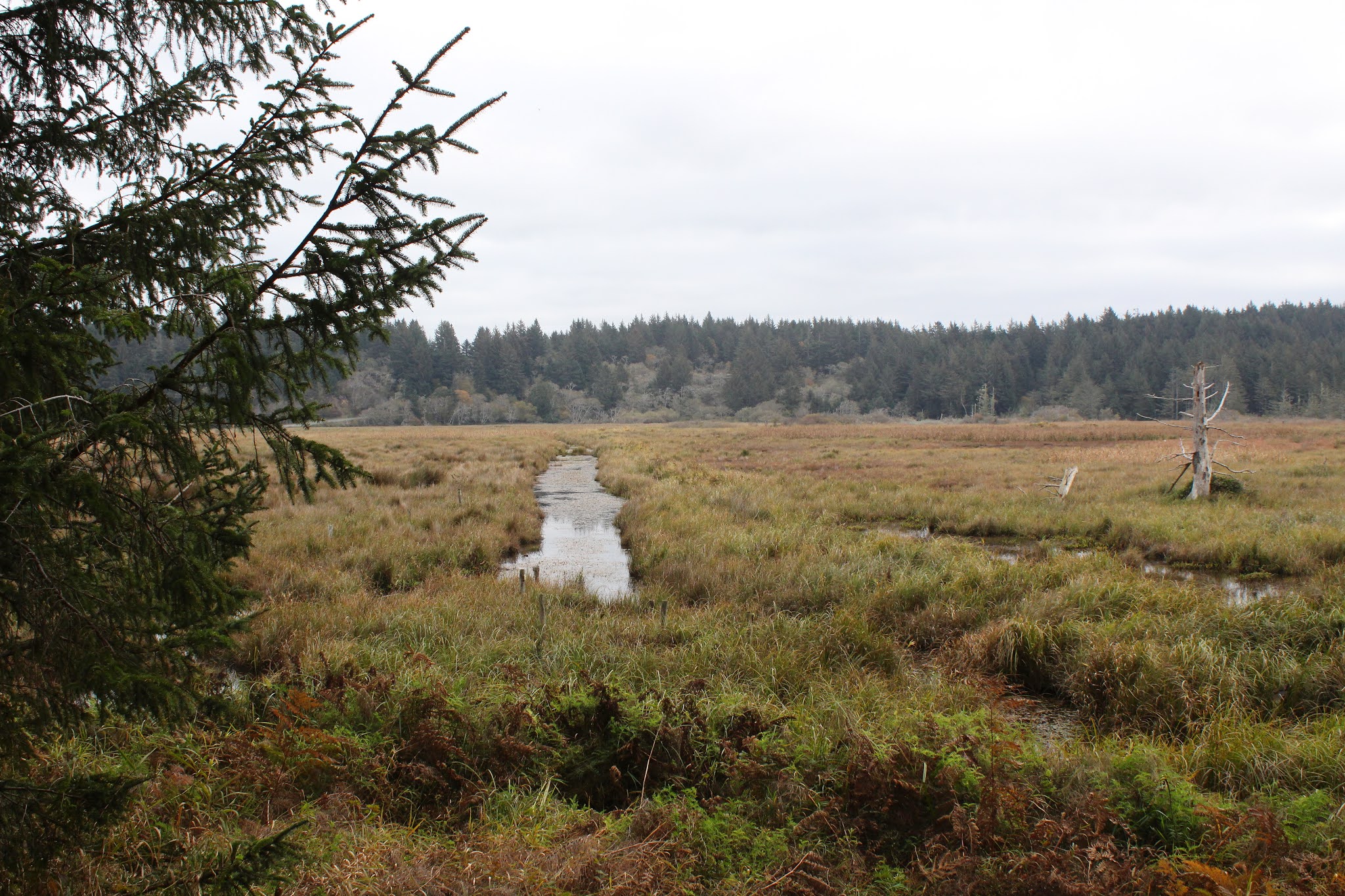
The weather was wet and drizzly, but never quite morphed into out and out rain. Pisgah's summit was hidden in the low clouds so it stood to reason fog would be a large part of my hike, particularly as the route gained enough elevation to enter the mist blanketing the mountain summit. I grabbed Trail 17 not only because it's a prime number but mostly because it connected with Trail 7, also a prime number. The path charged up the hill and within several minutes of hiking, the views were already fantastic as the path overlooked the rural farms, wetlands, and woods situated between the Coast Fork Willamette River and the small town of Goshen.

Still life with leaf and water drop

As stated, the weather was wet and drizzly and I spent an inordinate amount of time trying to take the perfect photograph of water drops hanging on twigs, branches, and tendrils of moss and lichen. After a short uphill walk on Trail 17, I grabbed Trail 7 which went both up and down at a rather rigorous rate. The slopes here consisted of dried grass with leafless oaks etched stark against the gray sky. The valley bottom, dotted with wetland ponds glistening in the dreary air, was spread out like the largest picnic blanket ever. I couldn't really stare at the scenery and walk at the same time, for the trail was muddy and slippery as it undulated up and down on the grassy slopes.

Moss rules the forest

Trail 7 dropped down to the North Trailhead and then began a charge uphill to both meet Trail 3 and to get out of the open slopes and into the forest. Trail 3 was a muddy track that met Trail 4, which commenced the forested portion of this hike. This part of Pisgah probably sees a lot of drizzle moisture, judging by the thick layer of moss covering all that does not move. I made sure to stay in constant motion, so as to avoid becoming just one more indistinct green lump on the forest floor.

Silent woods but for the drip, drip, drip

Here, the woods were mysterious and misty, the trees resembling ghostly spirits from the netherworld. Thick seines of branches strained water from the mist and the resultant drip, drip, drip was a constant accompaniment to what little sound I was making as I labored around the mountain. This was probably my favorite part of the hike. I probably made a little more noise when the trail rounded the mountain and began a pretty good climb up to Pisgah's summit, causing me to breathe more heavily and to mutter invective with ever increasing feeling and frequency.

The clouds begin to lift over Goshen

From the summit, one can allegedly see all the way to the Cascades but on a cloudy day with the summit socked in by fog, not so much. However, neatly coinciding with my arrival at Pisgah's summit apogee, the clouds began to lift and thin out, offering me something to look at besides gray mist. I hung around on the summit for a bit, totally entranced by the ethereal and evocative dance of clouds vainly attempting to retain their misty grip on the lands below the mountain. Little by little, the surrounding farmlands, pastures, and wetlands began to make an appearance. Since I'm old enough to remember tube TVs, the simile is that the landscape gradually swam into focus like a television set warming up.


Mud run on Trail 6

Trail 6 dives off the south side of Pisgah and when it's wet and muddy, it is eminently slippery and on more than one occasion hands and hiking poles were put to use in order to maintain me in my customary upright and erect position. From there, a reunion with Trail 3 took a longer route across the grassy slopes on Pisgah's west side. The trail was rough, rocky, and at times kind of sketchy, and it felt like home.

Trail 3 was rough and rugged, and I liked it

After a couple miles of Trail 3's rugged love, it was time to enter the Mount Pisgah Arboretum trail system. Most of the trails are short little loops or connecting trails that wander about the oaken woods of the aboretum. I grabbed the Upper Plateau Trail only because it had the words "upper" and "plateau" in it. Can't say it was as mountainous as the name suggested but it was a pleasant walk through some oak savannas and a grassy meadow. 

Weathered wood on a rustic water tower
    
The network of arboretum paths gradually dropped down to a series of swamps, ponds, and the Coast Fork Willamette River before closing the loop near some working farm buildings at the trailhead. By using the combination of trails cited earlier, this hike wound up being a respectable 7 miles long and was well worth the drive from Roseburg.

Scene from the winter of our content

For more photos of this hike, please visit the Flickr album.


Monday, December 23, 2019

Cape Arago night hike


Pop! Hissssss... Those are the sounds of a murder. In this case, the helpless and hapless victim was the right rear tire on my Jeep and the perp was a hollow metal tube that impaled itself at right angles to the tire wall, neatly allowing the air contained within to escape in a mere minute. At least I know the tire sensor and dashboard indicator work. At any rate, Coral Rae, Daweson, and I were temporarily stranded in Myrtle Point by the slain tire, wondering if we'd even be able to do our night hike at Cape Arago.

My hiking companions

Bad weather had raised havoc with my plans to formally lead a group on a night hike and eventually the whole project was given up on because there was no way to get a weekend hike in this close to Christmas. The whole point of the night hike was to see the Christmas lights at Shore Acres State Park which is why the hike needed to be done before Christmas. Anyway, the weather eased up briefly on the Monday before Santa's arrival and spurred on by some friends associated with the South Coast Striders, a hiking group based in Coos Bay, I decided to go and secured the attendance of grandchildren Coral Rae and Daweson.

We started out later than intended

However, the Striders were beginning a bit later than I wanted to, so the kids and I left early, fully intending to hike by ourselves, ahead of our Strider friends. But a strategically placed metal tube in a comparatively soft rubber tire put paid to that idea and the end result was that because of time lost by the tire repair, we wound up at the trailhead at the same exact time that buddy Tom and his Strider companions were beginning their hike. It was like it was meant to be!

And so it begins

Starting at the unusual time of 4:00 pm, a half-dozen hikers or so set foot on the trail beginning at Sunset Bay State Park. The afternoon already had that pre-sunset burnished glow about it and despite the sunlight, it was what could charitably be referred to as "chilly". And, after a mile or two of casual hiking, the sun and sky looked more like sunset than afternoon. By the time we arrived at Shore Acres State Park, the Oregon coast was definitely basking in the last hurrah of daylight. The golden glow was perfect for photography and we mingled with the hordes of sunset shutterbugs gathered at the whale watching station, most armed with cameras at the ready with which to capture the sunset.

Christmas lights, courtesy of Mother Nature

Hiking quickly, we dropped onto relatively quiet Simpson Beach, and then walked through some dark woods to reattain the coastal bluffs overlooking the restless ocean. Grabbing a faint path took us atop a secluded rocky point where we all plopped down on grass to ooh and aah at the coming sunset. The day's denouement was mere minutes away so we didn't have to wait very long before day slipped into night to the accompaniment of the roaring surf. The orange sun coloring sky and clouds was Mother Nature's own version of Christmas lights.

Even the lights have lights at Shore Acres

Once the sun was down, it was time for the true "night" portion of this night hike. We whipped out the headlamps and flashlights and backtracked down to Simpson Beach, the waves barely visible in the fading light. And from there, it was just a short walk to the bright lights of Shore Acres State Park, the glow in the inky black forest advertising the Christmas light display from afar like the neon lights of Las Vegas do as you approach on a lonely desert highway.

Shore Acres at its Christmas finest

Shore Acres State Park goes all out for Christmas and the formal gardens were flamboyantly adorned with all manner of lights, colors, and Christmas motifs. The grounds were a fairyland of glowing colors and a choir serenaded visitors from a brightly lit pavilion. Neon frogs jumped from lily pad to lily pad in the reflecting pond and heron statues eternally stalked but never caught a school of koi statues that never swam away. And, as is its wont, the reflecting pond contained a mirror world of light and color living their lives underneath the surface. As far as the kids were concerned though, the highlight of the Shore Acres gardens was free hot cider and a peek at Santa enjoying a bubble bath in the caretaker's cottage.

Excuse me, I'm taking a BATH here!
(How we got on the naughty list)

I've been night-hiking in the Cape Arago area for many years now and often felt like I was the only one adventurous enough to do such a thing. However, in recent years, it has been a more common occurrence to encounter hikers walking from Sunset Bay to Shore Acres, their presence announced in advance by headlights bobbing and weaving like drunk fireflies in the forest. There's a really good reason to night hike, beside the fact that night hiking in general is an awesome experience, and that is because the traffic into Shore Acres is horrendous, often backing up for several miles. But the train of cars were nice enough to us to let us make a left turn out of the parking lot and we felt grateful and maybe a little bit smug at having avoided the long line of vehicles moving slower than we could hike in the dark.

Season's greetings!

For more photos of this hike, please visit the Flickr album.


Saturday, December 14, 2019

Eel Lake


Eel Lake is a reliable go-to hike during Oregon's wet winter and does provide a healthy dose of lakeside scenery while tracing a route along the lake's forested shoreline. And so it was that on a damp and dreary December day, about eight of us set out on the trail to partake of the lake, rain, and all the mushrooms you could ever want to look at. Didn't see any eels though, not that we necessarily would have in any case.

Eel Lake on a gray day

This was mid-December, right on winter's cold and watery cusp, and naturally our venture turned out to be your basic quintessential winter hike. The sky was gray, full of pregnant clouds seemingly just about to deliver the baby, and we hiked underneath them while waiting for the water to break, colloquially speaking. There was nary a ripple on the placid surface of the lake which was as glassy as the eyes of a losing boxer. The recent rains had rendered the trail a muddy mess and the sound of boots slipping and sliding in the ooze could be heard as we hiked. Vegetation was wet and the sounds of complaining hikers with soaked pant legs could also be heard as we hiked. Winter is mushroom and fungus season and the forest was full of all kinds of them, slowing down a certain hiker with a compulsion to photograph each and every one.

A clump of ginormous mushrooms

As the civilized environs of William Tugman State Park receded behind us, we pretty much had the trail to ourselves. The basic rhythm of the hike was a walk through dark and damp woods to a viewpoint of the still and quiet lake on a gray day, then rinse and repeat for about six miles. The path also went up and down along the lake so we were able to keep internally warm from the exertion of hiking. Most of the alder trees flanking the path were bare but maples still sported a yellow leaf or two in a vestigial remnant of the recent fall season. 

The lake had more arms than a mutant octopus

Eel Lake at its widest point is only about a third of a mile wide, but the lake consists of two long arms making the body of water look like perhaps a U-shaped eel when seen from above. Each of the two arms have lots of little coves and bays serrating the eel-arm shoreline. The ins and outs add to the mileage of the hike but the trail only manages to conquer about 3.5 miles or so of lake shore. Frustrating, because there are several dozen more miles of shore to follow. I'd love to see a trail go all the way around.

Some of that swampy mess on the "trail"
    
After passing an idyllic little backpack campsite, the damp footpath rounded the entrance to a small cove and plunged down to lake level. The trail was slippery with mud and we sort of mud-skiied down to the bottom. I say "lake-level" but to call that swampy and fetid water part of the lake is an insult to lakes the world over. Basically, this was where forest met lake and if we thought it was muddy before, this was a whole other level of boot sucking. There was a sign that said "End of Trail" but you know us, we shouldered our way past and continued on to see what we could see.

On a winter's day

And what did we see, boys and girls? Muddy water, muddy boots, and muddy mud! We also saw an impenetrable wall of brush and a trail that faded into all of that tangle. It really was the end of the trail, so we turned around and headed back the way we had come. As we hiked back to the trailhead, the day became noticeably much more beclouded and quiet. The lake was like a slab of polished onyx and the whole lakeside atmosphere had that air of wet expectancy about it.

On a rainy December afternoon

Sure enough, the rain arrived as we were about a mile and a half away from the trailhead. Fortunately, raincoats and rain hats in combination with heavy forest cover aided in keeping us mostly dry. The smooth polished surface though, was now ruffled by thousands of overlapping concentric ripples caused by thousands of rain drops simultaneously striking the surface of the lake. The day was gloomy to start with but had darkened considerably, annoying those hikers toting cameras and trying to take pictures of everything.

It's now official: It's raining!

So, the hike finished with somewhat of a wet splash but you know what? It would have been a lot worse up high in the mountains. Besides which, we were all pretty much in unanimous agreement that a wet December hike was more fun than mowing the lawn in the sun. 

Dainty mushrooms thrive in a bed of moss

For more photos of this hike, please visit the Flickr album.


Saturday, November 30, 2019

Cape Arago


It's Oregon Coast Time, in terms of our hiking itinerary. Gone are those hikes high up in our beloved Cascade Mountains, because rainy weather down in the Umpqua Valley translates to snow in the higher elevations. Therefore, we tend to find ourselves a bit more often on the coast where the weather is generally more conducive to the wonderful avocation of hiking, even though there is an increased probability of getting soaked by rain, buffeted by wind, or crapped on by a seagull. And out of all the destinations on the coast, Cape Arago is definitely one of our favorites because of its relative proximity to Roseburg and the always reliably spectacular scenery.

The ocean was quiet...too quiet

Eons ago, the incredibly rocky and scenic shoreline at Cape Arago was formed when seismic events tilted the sea floor upward around 45 degrees. Nowadays, the resultant inclined sedimentary layers make for some incredible waves when the ocean kamikazes itself upon the rocks at high tide. Much photography ensues when this happens, and not just by me either, the area is quite popular with shutterbugs and hikers alike. Given the awesome ocean wavery in the area, we eagerly dashed up to the top of the forested bluffs overlooking Sunset Bay, fully prepared to be awed by the raging surf. Oops, we were ever so disappointed in the narcoleptically calm ocean, as still as a cat napping on a window sill, even though it was high tide. Heck, we might as well fold up our hiking poles and go home.

The beauty of the Cape Arago coast

The normally restless surf was serene and peaceful but despite that sad failing, the coast nonetheless was quite beautiful. The jagged shore was sticking its many rocky fingers up the ocean's nostrils, figuratively speaking, and the trail followed the serrated shoreline, meaning we went in, out, and around a series of coves and gulches. When the route veered inland and away from the coast, we found ourselves ambling through a green coastal forest full of sprouting fungi and mushrooms.

What do you call a chair with feet?
A toed stool!

Rachel was photographing a mushroom when Dave said "Wow, he looks like a fun guy!". Fun guy? Fungi? Get it? Rachel apparently did because she groaned audibly. I asked her to pick up a couple of fungi specimens, telling her if she did so, she'd be a "woman with loose morels!" Dave and I high-fived each other in congratulatory exultation while Rachel quickly scurried off, refusing to walk any further in our company. Wow, Rachel must have thought she was being pun-ished, but she was correct in her assumption.

Trees, personally invested in the outcome of rising sea levels

One aspect of climate change is rising sea levels and at Shore Acres, there are disturbing signs of the change mankind has wrought. Several times over the years, the trail has had to have been rerouted further inland because the old paths have tumbled into the sea as Oregon crumbles under the relentless maritime onslaught. In some places, they put fences on the old trails to keep hikers out but those fences have likewise tumbled into the sea as the coastline continues to erode. Also, the path sideswipes the old Shore Acres tennis court and now the erosion has eaten away at a corner of the old court. I can remember when not too long ago, it was safely out of reach, dozens of yards away from the ocean and eroding waves.

Tafoni formations at Shore Acres

Over the ages, the waves have exposed a rocky bench sited below the tennis court, uncovering all sorts of phantasmagorical rock formations and an ossified log or two. The formations here have always reminded me of the cemetary scene in a horror movie where zombies emerge from their graves. But today the rock formations did not want to eat my brains (and good luck finding any!) so I scrambled down there to observe and photograph the concretions and tafoni (rock formations that look like Swiss cheese) on the rocky bench.

The woods were full of mushrooms

The observation point at Shore Acres was amazingly still and quiet, both in terms of lack of people and crashing waves. But that's OK, there's nothing wrong with some peace and quiet and we enjoyed both of those things as we ducked into the woods and headed down to Simpson Beach. The woods were full of fungi and maybe a fun guy or two; much of my hiking time was spent lying on my belly on a muddy trail, taking photographs of the fungal splendors on the ground. 

What do you call an amphibian's hammer?
A toad's tool!

As we hiked in turn to the Simpson Reef viewpoint and to Cape Arago itself, the clouds became darker and the wind picked up a little bit. Clearly a storm was coming in so cameras were mostly put away and we hied it quickly down the trail so as to arrive at the trailhead before the sky broke loose. But, I had one more for Rachel. "Hey Rachel, what do you call a place to eat oatmeal!" I just get a blank look and a pair of shrugged shoulders. "A mushroom!" Mush room? Mushroom, get it?" Sheesh, tough crowd, I tell you!

Bad weather is coming

For more photos of this hike, please visit the Flickr album.

Saturday, November 16, 2019

Oregon Dunes


On the face of it, one can presume mid-November to be a wet, cold, and blustery affair at the Oregon coast. More often than not, you'd be correct in your presumption. But then again, there are semi-sunny days like this one where I tempted fate by hiking at the Oregon Dunes in shorts, but thankfully was not taken to task for my karmic impertinence. 

A crisp and clear morning on the beach

The weather was a little on the chill side and most of the Friends of the Umpqua group began the hike with jackets and full pant legs on, present deranged company excepted. I've found from past experience that if you start your hike dressed for warmth, you'll become overly heated within a few minutes or so of exertion. Me, I just start out like a first date: cold at first but plenty warm before too long. And sure enough, after the first mile or so of hiking to the beach, a large contingent of perspiring and overheated hikers stopped to remove some of their nine layers of clothing. After a few more miles of hiking it'd be pretty much a given that by then all hikers would be desperately sawing off pant legs. 

It was a pleasant two mile beach walk to Tahkenitch Creek

After our perfunctory walk to the beach and clothes-removal stop (jackets and coats only, you perverts!), we turned to the south and headed toward unseen Tahkenitch Creek, yet several miles ahead of us. The sky was sort of unusual in that it was gray on top but gloriously blue to the rear, just like me. Obviously we were hiking under a cloud border of sorts but we had nothing to declare as we passed through customs. 

Lane horks up a jellyfish

The beach was littered with debris, deposited onto the beach strand courtesy of some recent storms. Logs and driftwood were strewn about and in one case, a fully branched tree in its entirety. Clam shells, sand dollars, and jellyfish were all found and examined by beachcombing hikers, the jellyfish resembling the largest and slimiest boogers ever. 

Moody clouds hovered over Tahkenitch Creek

We ate lunch at Tahkenitch Creek to the accompaniment of keening sea gulls doing the same thing. I think we had the better food though, but we were entertained watching the birds forage at the water's edge. Tahkenitch Creek looked to be more river than creek, being quite wide as it reached the end of its journey and the same thing can be said about most of us too, now that I think about it. As we lollygagged, ominous looking clouds scudded overhead and we wondered if we were going to get rained on or not. We didn't and the blue sky to the north remained although it became less and less a commodity as the increasingly cloudy day waned.

The world within Tahkenitch Creek

After a couple of more miles of beach walking, we left the beach via Exit 114, the bright neon yellow sign totally at odds with the foreboding gray sky above. The plan here was to make a loop hike through the Oregon Dunes, but first we had some forest walking to get through. A side trail in the woods led to a viewpoint of Tahkenitch Creek, its overly calm surface reflecting the weak sun fighting its way past the cloud cover. A resumption of the forest walk led us to another awesome overlook of Tahkenitch Creek.

Tahkenitch Creek takes the long way home

Here, the creek snakes to and fro in a series of exaggerated oxbow bends below the sandy dunes, resembling a large watery snake lazing or slithering in the sun. It's a spectacular sight and we stopped for a few minutes to admire the sinuous serpentine curves of the creek before resuming our journey across the sandy dunes.

Hi ho, hi ho, across the dunes we go

In the dunes, there is no formal path per se, but marker posts keep hikers on track and in theory prevent the map and compass-challenged set from getting lost. It was several miles of sandy dunes, beachgrass, small lakes, and ponds before the trailhead area appeared, inconveniently sited on top of a large hill made entirely out of sand. Just to do something different, Lane and I opted to hike up the sandy slope instead of grabbing the customary trail through the coastal woods.

Why we walk uphill in soft sand

Oof! That turned out to be quite the Sisyphean struggle because for every two steps up in the soft and shifting sands, we slid down one. Although at times, it felt like we backslid three steps for every two. But the fun part of this impromptu route came not from the awesome view of the dunes and distant ocean, even though that was pretty cool too, but by virtue of the fact that our people were expecting us to appear on the trail, and not from the rear. "Watch this!" said Lane, he of the evil grin. He pressed the panic button on his key chain and his vehicle, which everybody was leaning up against, exploded into honking and flashing chaotic cacophony. You know how it is when you touch a cat that is all coiled up, ready to pounce and the startled feline reflexively launches skyward, arms outspread in an involuntary four-limbed crucifix pose? Yeah, it was kind of like that, making a great hike even more enjoyable!

The day darkens as the hike ends

For more photos of this hike, please visit the Flickr album.


Saturday, November 9, 2019

Cape Blanco (via Sullivan Gulch)


Cape Blanco State Park is one of my favorite places to hike at. To nit-pick a bit though, there's a sameness to the trail network in that all possible routes essentially follow the coast from the Sixes River to the Elk River or vice versa. Yes, you can hike either atop the forested coastal bluffs or on the beach but either way, you are pretty much hiking from the Sixes River to the Elk River or vice versa. But as I recently found out, there is an inland approach that begins at Sullivan Gulch. Yay, somewhere I'd never hiked before, and naturally, the alluring "new trail" siren song called out to me. Powerless to resist its haunting melody, I soon found myself lacing boots at the cattle gate that serves as the Sullivan Gulch trailhead.

For some reason, we did not take this trail, not really sure why that was

Accompanied by my trusty sidekick Lane, I opened the cattle gate and our hiking festivities commenced with a walk up a grassy ranch road flanking the west side of Sullivan Gulch. Per the Oxford English Dictionary, "gulch" is defined as a "narrow and steep-sided ravine marking the course of a fast stream". Well, Sullivan Gulch is not narrow, nor is it what I would call a ravine, and good luck finding a fast stream in the marshy wetlands. The wide swale with plenty of standing water in it does have steep sides though, but the trail here sort of cheats past by finding a gap in the steep sides on its way to the beach.


Waterway in the Sullivan Gulch wetlands

The first part of the route followed the wide grassy marsh containing ponds, drainage ditches, and various other forms of standing water in and among the marsh grasses. Ducks make a home in the ponds and regrettably, our arrival caused them to flee their watery abode in quacking panic. A more intimate exploration of the gulch was effectively discouraged by wire fencing and standing water, so we just looked and did not touch.

Mother and child, toxic mushroom style

It didn't take long for both of us to decide we really like this trail. The path gradually left the edge of the marsh and we hiked in woods sublime. White-trunked alder trees were already leafless, proffering their bony limbs to the sky in supplication for the return of leaves purloined by winter's arrival. Closer to ground level, the greenery was still thriving, unwilling to surrender their leaves like weak-willed alders. Ferns draped over the trail and mushrooms were everywhere. This was too much to expect two dudes with cameras to walk through without engaging in much photography. Consequently, it was slow going through the woods to an overlook of the beach from atop a tall dune.

Bushwhacking is fun!

Before we hit the beach though, we followed an obvious path leading into the forest, curious to see where it went. 
As it turned out, it pretty much went nowhere. The well-defined path quickly degenerated into a loose network of deer paths, game trails, and thick forest clawing at us as we fought our way up a ridge. Eventually, we wound up at the edge of Sullivan Gulch, wrestling head-high grasses while mud sucked at our boots. While fun, the bushwhack venture yielded little reward, so we bushwhacked back to the sandy saddle above the beach.

The mighty Elk River

The tide was out and the exposed wet sand was hard-packed (just like my abs, hah!) and perfect for hiking on. We beach-walked south for about a mile before the swiftly moving Elk River barred further progress south. Surprisingly, the fairly remote river was in use by a moderate population of salmon fishermen. After an obligatory lunch and laze next to the river, Lane and I returned to the overlook atop the dunes.

A sea of silver mercury

Feeling adventuresome and walky, always a potent situation, we grabbed a footpath that headed straight up through some woods. The whole vibe of this section of trail felt like wilderness because we did not see a single soul as we trudged upward. The trail served up some expansive views of Sullivan Gulch and the beach south of Cape Blanco as our route zigged and zagged from the ridge crest to the east side and then back again. After a mile or so of this, the path crested at what presumably is the tallest point in the park.

Flocks of geese head north

Oh, the things we could see from the top! The beach lay immediately below our clifftop perch, albeit several hundred feet below. Fishermen and beachgoers looked like ants on a kitchen counter and their vehicles like little Matchbox toys waiting to be picked up by a giant hand. Offshore loomed the ocean, glinting silver in sunlight diffused by an indistinct cloud layer. Ah, now this is why we hike!

Lane and Richard go for a hike

After admiring the view from our clifftop aerie, it almost seemed anticlimactic to cut across the horse camp and take the trail back to Sullivan Gulch. However, the forest was lush and green and the trail challenged our legs as it dropped straight down into the gulch. I do mean straight down, for the trail plunged as fast as a wingless duck, putting our quad and glute muscles to the test as we bravely resisted the pull of gravity on the way down. Once back down to gulch-level, the hike was finished off with a short walk on a grassy path covered with crawling newts. I think this is my new favorite hike at Cape Blanco State Park.

They say the spirit of Sullivan still haunts the park

For more photos of this hike,
please visit the Flickr album.