Saturday, March 31, 2018

God's Thumb

New trail! That's all I need to hear and I'm in. The new trail in question was a loop route from Road's End State Park (in Lincoln City) to God's Thumb and back. Basically, people were hiking to God's Thumb anyway, but by way of hiking across and parking on private property. Fortunately, the Lincoln City Parks Department stepped in and installed a legal path to the Thumb. Because they want us hikers to play nice with the neighbors, they ask you begin at nearby Road's End State Park and access the trails via a short walk on city streets. There aren't any signs directing out of town hikers which way to go and as I laced up my boots at the park, a steady stream of would-be hikers stopped to ask me if I knew how to get to God's Thumb. Ever the smart aleck, I wordlessly pointed down the Oregon Coast and there it was: God's Thumbnail (only the upper portion of the Thumb was visible) waving in the breeze from several miles away, forever thumbing a ride into our hiking hearts.

Not bad, for a road walk
Despite the request to begin hiking at Road's End (and boy, do I approve of that name!), I think I was the only one complying with the play-nice rules. Basically, you cross the street from the park entrance and grab gravel Sal-De-La-Sea Road. Even though this was a city road, it was eminently quiet and I saw nary a car during my short stay on the road.

Can't see the forest for the trees
About a mile up the road, there is a trailhead that according to a map on a signpost, hooks up with the trail to God's Thumb, possibly making this a more reasonable 6 or 7 mile loop. However, my set of instructions pertained to the shorter 4.5 mile loop and I didn't feel like toting the signboard and post with me on a longer hike. So, onward and upward on the gravel road to the upper trailhead I went. At least the woods were pretty, with a mix of conifer and leafless alder trees flanking both sides of the gravel lane.

A rare level stretch of trail
Right where the road turned from gravel to dirt, a small path forked off to the right and from now on, I'd be hiking on a real trail. This section of trail was a former road bed and it just charged straight up the hill with nary a pretense of switchback, about as subtle as an exploding stick of dynamite. Before long, leg muscles were screaming with the sweet agony that comes with hiking up a steep trail. It was great!

View from the grassy knoll
Screaming leg muscles were given a rest at the top though, by taking a side trail to a grassy knoll for the first of many scenic overlooks on this trail. Lincoln City, Devils Lake, and the Oregon coast stretching out all the way to Government Point: under a gray and brooding sky all these geographical features lay below the knoll like on oversized 3-D rendering on a gigantic atlas page. Such a view required a lengthy and contemplative appreciation so I indelicately plopped down in the damp grass and did that very thing.

Columbia windflower, nowhere near Columbia
If I thought the trail coming up here was steep, that was nothing compared to the trail leading to God's Thumb from the knoll. The only good thing was that I was going down it instead of up. I met other hikers coming up, though, and most were red-faced and not smiling. The slope was heavily forested and Columbia windflower and candy flower were blooming along the steep trail.

Scenic little meadow on a ridge
The trail bottomed out on a meadowed saddle, the meadow ringed with white-trunked alder trees leafless and twiggy. Unfortunately, I also had a clear view of the trail leaving the meadow, climbing straight up a grassy hill before disappearing into a forest where, no doubt, more uphill hiking awaited me.


First look at God's Thumb


It wasn't too bad though, mostly because the steep portion was short and besides which, the forest comprised mostly of alder had it's own little charm, best observed bent over with hands on knees, while simultaneously panting heavily from exertion. A short little climb over a grassy slope bordered by a dense thicket of leafless and twiggy salmonberry, provided the first view of God's Thumb about a half mile ahead.

Dizzying view from the edge
The Thumb is a small promontory atop a large cliff directly above the sea. To the right, the ridge and thumb were abruptly edged by a sheer drop-off, the Thumb seemingly chopped off by the meat cleaver of the gods. Resembling little ants from a distance, hikers were coming and going, or atop God's Thumb itself. There were no trees, it was all windblown grassy slopes and my little trail hugged the edge of the drop-off, descending rapidly before ascending up to the summit in equally rapid fashion. I tell you, trail designers will NOT go to heaven!

Faint path on God's Thumb
Picking my way very carefully so as not to trip and fall to the right, which would make this my very last blog entry ever, I made my way down to the saddle below the Thumb. The views were tremendous but I didn't really look, choosing to concentrate instead where I placed my feet. A woman was butt-scooting down the hillside from the thumb and hikers behind me and several coming up from the lower trailhead turned back at this point. Actually it wasn't that bad, but you do have to be be careful and deliberate.

Lincoln City, from the summit
The views were simply tremendous and magnificent from the summit. Same old awesome view to the south with Lincoln City and the Oregon coast stretching out to Government Point on a gray day. To the north was Cascade Head, resembling a larger version of God's Thumb, with the Salmon River estuary separating the two promontory landmarks. The mountains above Cascade Head disappeared into the clouds; I imagine the view would even be better on a sunny day. Probably the summit would be crowded on a sunny day, too. Anyway, the summit was just the perfect place to eat lunch, rest, and generally contemplate the meaning of life.

I'm so sorry, dear boots of mine
The lower trail is also the shortest route to God's Thumb and naturally, was quite busy with hikers coming up from the lower trailhead. The rough footpath wandered through woods facing the ocean and the recent rains had made the track exceedingly muddy and slipperier than an eel bathed in snot. Boots were most definitely harmed in the hiking of this hike. Because most hikers were tennis-shoed and be-sandaled "casuals", the trail braided as hiking amateurs desperately forged alternate paths to get around the muddy spots. Not me though, I just waded through the mire.

Beach at Lincoln City


A brief road walk from the lower trailhead led me to a staired beach access and from there, it would just be a simple beach walk back to Road's End State Park. Lincoln City is rather touristy so the beach was fairly well populated with runners, kite flyers, surf waders, and at least one hiker with muddy boots who was quite happy to have gotten in a hike on a new trail.

Salmonberry blossom
For more pictures of this hike, please visit the Flickr album.

Note: The route is not marked at all and there are several trail junctions you want to make the correct turns on. Follow this link to a newspaper story that has a blow-by-blow description of the hike. It's the guide I used and I'll vouch for its accuracy.


Saturday, March 24, 2018

Heceta Head

"Thanks, Rheo!" is the theme of this soggy and cold blog missive. The weather report had been rather dire with lots of water forecasted to fall from the sky and I had pretty much decided I was not going to go. But then Rheo called and asked me to take her place as hike leader, citing the very convenient excuse of having to recover from foot surgery. That's a pretty lame excuse if you ask me, foot surgery pun intended. At any rate, it was a sparsely attended hike with just 4 other intrepid hikers (and one dog) braving the elements, led by one hike leader muttering "Thanks, Rheo" every quarter-mile or so.

"View" from Heceta Head
When we left Roseburg, it was actually sunny and we were ever so naive and optimistic as we hopped in the cars and headed to the coast. By the time we hit Reedsport, it was obvious we had left the good weather behind. And by the time we hit Devil's Elbow State Park at Heceta Head, we all knew we were in for it, as a steady rain beat a staccato rhythm on the windshield. All dressed up and with somewhere to go, we set out on the trail with a "Thanks, Rheo!".

Heceta Head Lighthouse
A short uphill climb on a wide gravel path took us to Heceta Head Lighthouse and it was raining hard so we just sideswiped that particular attraction and ducked into the woods on Heceta Head. Anything to get out of the rain, even if it meant slogging up a steep and muddy trail. I had eaten a fast food breakfast and right about now, it sat in my stomach like a 16 pound bowling ball n the rack, and I was wondering if I was going to hork up breakfast before cresting Heceta Head. I'm glad to report that no breakfasts were horked on this hike.

A forest hobbits could love
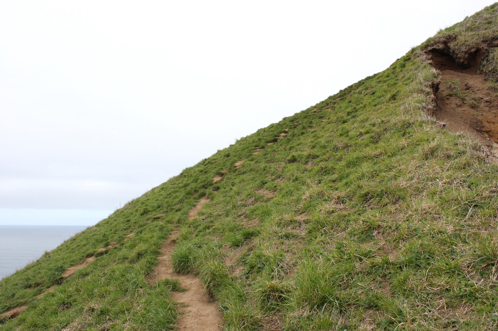
Fortunately, the climb to the top of Heceta Head was finite and I was a happy hiker when I no longer had to haul my bloated bulk uphill. But be careful what you ask for Richard, for the trail off the head was steep, muddy, and slippery enough to qualify as treacherous in places. The wind blows pretty regularly here and the trees were phantasmagorically shaped by the wind, or maybe they were just born that way. At any rate, a brief opening in the forest provided a heavily clouded look to the beach  below where normally there would be an awe-inspiring view, as long as you didn't think too much about the 500 foot elevation gain hiking back from the beach.

"Thanks, Rheo!"
The trail leading down to the beach is whimsically called the Hobbit Trail but the hobbits were all in in hiding or hibernation from the constant rain. We weren't and for some reason, we saw no other hikers out this day, not sure why that was. Once on the beach, miles of wet sand stretched in front of us, the moisture glistening on a darkly gray day. 

Heceta Head, in the rain
About the only good thing about the weather was that the wind was at our backs, which made the rain just a smidge more tolerable. At this point, it was a given that we and our gear were quite wet and it just got to the point that you couldn't get any more wet that you already were. So, it was like "whatever" and somewhere on the beach I began to actually enjoy the hike. Or maybe "enjoy" isn't quite the correct word, "endure" might be closer to it, but I really and truly was beginning to enjoy the endurance of the hike, thereof. Or maybe it was just the early onset of rain-induced dementia setting in.

A bald eagle roosts in the inclement weather
Although we did not run into any other hikers, we did spot some wildlife, most notably that of a bald eagle sitting on a bare branch, totally unfazed by both the steady rain and our presence on his erstwhile lonely beach. He allowed us to not-so stealthily approach and take photos of his majestic birdness. I say he, but he could have also been a she too, I suppose.

Gnarled and twisted, like my feet
We exited the beach at Carl Washburne State Park and normally, this is where we eat lunch. But the idea of gathering around a picnic table out in the open, munching soggy sandwiches, didn't seem very appealing so we just continued on, hiking through woods comprised of trees gnarled and twisted by frequent sea breezes. 

China Creek, in the all-day rain
The hike back to Heceta Head was spent mostly in wet and dripping woods dark and lovely, on a trail that loosely followed Creeks China and Blowout. There was a small pond, formed by a beaver dam, but not all hikers saw it, choosing instead to focus on maintaining footing on a slick trail.

The sign of a good hike
By now, I had forgotten my peevishness at my friend Rheo but I was getting there again, slogging back up and over Heceta Head on a trail that had, if anything, gotten more muddy and slippery while we were hiking on the beach and back. Sure enough, on the way down, my left foot lost footing and I went on about a 10 yard slide on my back down the trail. "Thanks, Rheo!" and this time I meant it. After arriving home, I read an e-mail from another hiking group that had scratched their coast hike this weekend, because "no one would be crazy enough to hike in this weather". Heh, heh, that was not entirely true now, was it? Thanks, Rheo!

The baleful eye of Sauron gazes upon us
Because of the wet weather, I didn't take a lot of pictures but the few that I did take are in the Flickr album.


Saturday, March 10, 2018

East Applegate Ridge Trail

The original plan was to take it easy on all my hiking buddies by making this a one-way mostly-downhill 5.7 mile hike. The Friends of the Umpqua had never been on this relatively new trail in the Siskiyou foothills and my thinking was to make this fantastic hike as pleasant an experience as possible. But then Traci showed up.

A grove of always photogenic madrone
When I gave my little explanation about this little hike, she exploded in righteous indignation "What?!", further adding "I drove all the way from Coos Bay and I want my 10 mile hike!". And then she held her breath, silently daring me to stick with the 5 mile plan. Since I really didn't want her to pass out from asphyxia, I acquiesced and that is the story of how I came to hike the long uphill back to the car.

The not always photogenic hiking club
Initially, the day was overcast although the sun did come out for extended visits. The temperature was perfect for hiking, hovering somewhere in the high 50's or low 60's. In short, it was ideal conditions for a spring hike and unsurprisingly, the path was busy with other hikers and trail runners. Our friends Glen and Carol from Medford were waiting for us at the trailhead, having already hiked up from the lower trailhead. I think they should be friends of Traci, if they weren't already.

Trail to nowhere
After 50 yards of hiking through a lightly wooded forest, the first view of Bishop Creek's deep canyon came into view and the oohing and aahing began. This hike is all about the views of the Applegate Valley and the surrounding mountains and foothills. I had promised a downhill hike but the first mile or so was a gradual uphill walk before the trail plunged for good down to the valley floor.

Storksbill
The route contoured across grassy slopes starting to green out with spring growth. At the right time of year, this area is probably bursting with wildflowers but on this day there was only the odd specimen of yellow desert parsley and plenty of pink storksbill, a small geranium whose seeds will be sure to get stuck in hiker's socks later on in the year.

Leafless oak abstract
As the trail zigzagged down the grassy ridges, elevation was being lost at an alarmingly fast rate. Alarmingly, because we were going to have to walk back up the trail, thanks to Traci's parking lot tantrum. Just past the mid-point, Lane and Colby turned back and Traci's group (including me) turned back right where the trail morphed into an old road bed. Brad had gone all the way to the lower trailhead so he, Glenn, and Carol get the Golden Boot award for hiking the entire trail in both directions.

Nowhere to hide


No complaining about the hike back up because a) that's whining and b) the views were totally awesome and should be enjoyed on a contemplative slow walk uphill. The sun was mostly out, although clouds occasionally blocked out that glorious Vitamin D-sustaining sunlight. Lizards skittered in the leaves and grass next to trail, including one unlucky bluebelly that tried to hide in a decaying log, totally exposed in a crack for all of us to take pictures of. Oh, the indignity!

Graceful curves


Our version of this hike came in at about 9 miles, a very worthy distance, especially in view of the elevation gained on the return leg of the hike. In the back of my mind was a little voice pointing out that had it not been for Traci's hissy fit, I could have hiked 5.7 easy downhill miles like everybody else. Happily tired as I unlaced my boots at hike's end, I decided I was eminently grateful Traci's well-played tantrum made me do the longer version of this hike. 

Still plenty of snow in the Siskiyous
For more pictures of this hike, please visit the Flickr album.


Friday, March 9, 2018

North Umpqua Trail - Panther Segment

Sometimes, you just have to be in the mood and clearly, I wasn't. The rain was pouring down and the temperature was cold, hovering just this wet side of snowfall. That was cause enough for me to throw up my hands and whine "I just want to go home". And after a paltry 4 miles of hiking, I did that very thing, much to the disappointment of my canine companion, Luna. Its really too bad, because visually, this is a beautiful hike and on a slightly less belligerent day, the hike would be as eminently enjoyable as a homemade enchilada.

Wild ginger flower
March comes in like a panther and out like a lion, or something like that, and this March was no exception, snarling and screeching in with a series of rainstorms that really tested one's resolve to hike every weekend. On this particular Friday, the morning dawned dark and gray with a steady stream of fat raindrops pattering against the living room windows. I really didn't feel like hiking in that crap but figured if I could just get  out to the trailhead then the joy of hiking would rekindle the smoldering embers inside my hiking heart, just like it always does. I was wrong.

Even on a rainy day....
Luna was game though, and bounded up the North Umpqua Trail in unrestrained ebullience that quickly resulted in her getting leashed for the remainder of the hike. She has no filters and the forest has so many squirrels in it. As we set out upon the trail, the rain was tapping out a steady drumbeat on my hat brim, and we were surrounded by the three-dimensional aural hiss of rain falling throughout the forest.

A small piece of the North Umpqua River
The Panther Segment of the North Umpqua Trail spends a lot of it's miles high above the North Umpqua River, and started out by immediately charging uphill to get up there. In no time at all, I was sweltering underneath my raincoat, despite the chilly weather. The turquoise color of the river, muddy and silted with increased runoff, could be seen here and there between the trees in the dense forest. 

Soggy and happy
Despite the wintry vibe, spring is definitely here. Lavender sprigs of snow queen were abloom everywhere and one ugly brown wild ginger flower was spotted by your merry blogster. On mossy cliffs with rain dripping off everything, happily soggy (or is it soggily happy?) saxifrage plants were offering up small white flowers as sacrifice to the rain gods. 

Sun, please stay longer than 30 seconds
At the crest of a rather vigorous climb, the sun actually came out and I could almost hear a choir of angels sing as a sunbeam lit up the trail. I stopped to take off layers and jackets but before I could actually consummate that task, the sun disappeared and the rain resumed. That was such a tease!


Mushrooms in the moss
One of the many things I like about the North Umpqua Trail is the rampant greenery along the trail. The river canyon traps humidity and the forest is amazingly lush. Mushrooms sprout on trees, ferns and Oregon grape carpet the forest floor, and moss covers all inanimate and sedentary objects. Today was no different and much photography ensued.

One of a million creeks crossing the trail
The rain had all manner of creeks and streams cascading down the forested hillsides and I daresay boots got wet as I waded where they crossed the trail. But the rain was really coming down by now, and enthusiasm by the human half of our hiking contingent was waning. At the 1.9 mile mark, a fallen tree cinched the deal.

Some of that winter blowdown
The tree was over waist-high and lay perpendicular across the trail, effectively blocking the way. Luna hopped on the log and promptly skidded and slid down the inclined trunk before hopping off about 10 yards downhill. I declined the opportunity of repeating her experience. Half the tree was uphill which would have required an extremely tedious and muddy bushwhack up and around a sizable root ball. And on the downhill side, the upper half of the tree lay on a steep slope covered with riverine jungle. Good enough for me on this wet day, and we turned around.

Sun again, for thirty seconds, again
On the way back the sun came out again, just enough for me to feel bad about turning around. And then it was never heard from again as incessant heavy rain started up for good. I figured that when we made it back to the trailhead, we could continue hiking on the Calf Segment for some decent mileage.


Panther Creek runs into the North Umpqua


However, the Calf has been burned up in several forest fires over the last decade and accordingly, there is not much in the way of trees flanking the trail. We were totally exposed to the elements and the Calf Segment demonstrated the difference between rain falling in forest and the totally unfiltered version of the same rainstorm. That was it, no more hiking for the day; so back to car we went, figurative tails between our legs. You just have to be in the mood, and I wasn't.

British soldiers in the moss
For more pictures of this hike, please visit the Flickr album.


Sunday, March 4, 2018

North Umpqua Trail - Swiftwater Segment

Bit by bit, springtime is coming! Sometimes its hard to believe, like when copious amounts of rain fall on the deck outside. Drive up the North Umpqua Highway to about 3,500 feet of elevation while your car slips and slides in the ice and snow, and it'll still feel a lot like winter. But in between the ample precipitation leaking from the sky, there are signs here and there that winter is on the way out. Occasionally, sunlight breaks out and the temperatures are at least 10 degrees warmer than it had been most of February. Twittering birds commence constructing nests in the branches while underneath the trees along the North Umpqua Trail, the diminutive lavender blooms of snow queen carpet the florest floor. Yes, I know that winter will have a thing or two yet to say about the arrival of it's seasonal arch-nemesis, but it sure was nice to hike on the North Umpqua Trail without getting frozen or soaked for a change.

Woodland violet
So, the day was not great but on the other hand it wasn't raining...too much, anyway. That was good enough for Luna and I, we saddled up and drove over to the Susan Creek Day Use Area for some winter/spring hiking. As we started, the trail was blocked by a large fallen tree lying across the trail. After a quick scramble over the dearly demised tree, we had to stop again to take pictures of some of the many clumps of snow queen blooming next to the trail. Oh, and there was some woodland violet and twinflower too, which required more lying prone in wet vegetation, snapping a few dozen photos of every flower. Well, to be exact, Luna waited patiently for me while I did my photography thing and I could sense much rolling of eyes behind my back when I wasn't looking.

Tick-harvesting hiking companion
A half-mile and a half-hour later (thanks to the snow queen), we crossed the North Umpqua River on the always picturesque Tioga Bridge, the orange wood of the bridge contrasting nicely with the turquoise waters of the rain-swollen river. Luna too contrasted with most everything, since she is entirely black except for the one patch of white on her throat and chest.

Moss creeps over a bald spot
Once across the river, there were two options for hiking: right turn or left turn. The left-turn version would be on the Tioga Segment of the North Umpqua Trail, but a sign warning of a trail closure several miles ahead cinched the deal. "Not Closed": I like that in a trail, so right on the Swiftwater Segment it was. The Tioga Segment had been ravaged by wildfire last summer and the Forest Service is rightly concerned about landslides and falling trees, plus no doubt most of the wooden bridges were burned up in the fire, too. I'm not averse to getting my feet wet but some of those little ravines would be quite tedious to get across without a bridge spanning them. And as tempting as it is to hike past the closure signs and explore the wild post-fire scenery, there is a hefty fine involved if you happen to be caught and cited. In my post-retirement budget, there is not enough room for a "stupid-tax".

Lots of water in the forest


The Swiftwater Segment was fine though, as it angled gently uphill on an old gravel road bed for most of the first three miles. The vegetation was lush and water soaked, my legs would have been sopping wet had we had to hike on a real trail with encroaching vegetation. We had to endure several short rain showers and I had plenty of opportunity to take photographs of water drops dangling off of branches, leaves, and runny noses.

A small creek crosses the trail
With all the rain coming down in the last week, it stood to reason there'd be plenty of water running in all the seasonal unnamed creeks crossing the trail. And yup, there certainly was and I have hundreds of photographs to prove it. At this rate, we'd spend all day on the trail just to attain one mile of hiking distance!

Moss creeps over a rock


The forest bryophytes (that would be a fancy term for moss, dearies) were on full display here on the shady side of the river. Between the lush vegetation and the ample quantities of mossage (bryophytage?), green was the operative color on the North Umpqua Trail. Moss covers all that does not move, so Luna had no worries, but I had better put the camera away and hie myself smartly down the trail lest I too become just another indistinct green mossy lump in the forest.

So many creeks on the trail
As stated before, the trail was angling up and away from the river and the forest did a pretty good job of hiding the river from view. In several openings in the dense woods, we got rained on and we could see the bright turquoise color of the river water down below through the trees. Nonplussed by the rain, small birds flitted in the damp shrubbery like so many feathered ping-pong balls, attracting the attention of one easily distracted dog.

Snow queen


At about the three mile mark, we came across an area that had been logged right next to the trail. I have to think that the logging activity probably had some connection to last summer's wildfires, although the logging seemed to have occurred more recently than last summer. Civilization further intruded when the trail separated from the old roadbed and followed a not-so-attractive clear-cut beneath some power lines before ducking back into yet another lush forest.

Bob Creek
A short drop through the thick lichen-encrusted woods brought us to Bob Creek, it's footbridge still intact and untouched by fire. That was a logical turnaround point and we rested a bit and ate treats before turning back. On the way back the rain ceased and the sun broke out. There is a saying about Oregon "if you don't like the weather, just wait five minutes" There should also being some saying about experiencing summer, spring, fall, and winter all in one day, but that's just me whining.

Susan Creek
At any rate, in keeping with the adage cited in the previous paragraph, the rain returned by the time we reached the car at the end of a shortish 5.5 mile hike. More mileage was called for, so rain notwithstanding, we crossed the highway and resumed hiking on the Susan Creek Falls Trail, a short but heavily used path to the spectacular falls.


Susan Creek Falls on a rainy afternoon
The trail had been graded, graveled and fence-railed into submission and I get a little peeved when comparing this path to my normal ankle-twisting trail tread. But then it wouldn't really be hiking if all trails were like that, either, so I'll stop with the complaining. At any rate, Susan Creek Falls were predictably spectacular, particularly with the spring runoff increasing both the aural and water volume of the cascade. We didn't tarry long at the falls, for the rain was a little more insistent by now, it was just as well we turned back for the wonderful and heavenly warm air that can only be obtained from a car heater on a cold and wet, yet fine spring day.
.
The color of the river is amazing
For more pictures of this hike, please visit the Flickr album.