Showing posts with label humbug mountain. Show all posts

Saturday, January 8, 2022

Oregon Coast Trail (From Humbug Mountain day use area)


Ah, there is nothing like the feel of rough trail beneath your boots to make you feel alive and well. But then again, near prominent Humbug Mountain, there's a segment of Oregon Coast Trail that's on a section of old highway, replete with old asphalt. Nonetheless, this little piece of the OCT is a favorite of mine in spite of its paved shortcomings, especially since at least half the hiking route is on a real trail with dirt, roots, rocks, and everything. The Friends of the Umpqua had never been here before so as sole keeper of the knowledge of this trail, I was tapped to lead this hike.

Brush Creek flows by the brushy banks

Setting out on a cool but sunny winter morn, we crossed a manicured lawn at the Humbug Mountain day use area and found the path running under a Highway 101 bridge. For the first part of the hike, the route followed Brush Creek, which brushed by Highway 101 (see what I did there?) on the other side of the brush-lined creek. There used to be a fish hatchery here and the trail sideswiped the crumbling ruins, giving us a look-see at what once had been in the aqueous world of fish rearing.

Typical vibe hiking in the myrtle groves

The hike was a pleasantly level amble next to the burbling creek for maybe a mile or so before turning a bit less pleasant. The route was basically going up and over a densely wooded ridge and while the uphill was work, the tedium fortunately did not last very long. The woods here were sumptuous and lush, being primarily comprised of myrtle trees, whose pleasantly aromatic leaves dispelled any other odors that may have been left behind by the odiferous hordes hiking ahead of me.

The once and former proud Coast Highway

Once the forested ridge was crested, it was a quick drop down to a gravel road, followed by a short walk on the campground road proper. Fortunately, Oregon Coast Trail markers significantly cut down on any would-be confusion and I'm glad to say no hikers (other than Brad!) were lost or misplaced. From the campground road, it was now time to grab the historical highway heading upward through the woods.
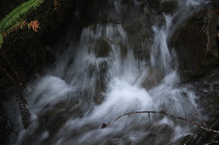
Small creeks flowed everywhere

Dry Creek isn't very dry and a stout bridge spanned the noisy stream tumbling down its ferny canyon. While the day was pleasant and sunny, the week prior it had not been. High winds and heavy rains had pummeled the coast and accordingly, all manner of creeks and seasonal runoffs were tumbling down the steep slopes next to the old road. Fortunately, because of the trail's previous incarnation as a major highway, functioning culverts made sure to run the water underneath the roadway and not across.

Wind-littered trail

As the paved trail climbed away from Humbug Mountain Campground, we traded in myrtle groves for mixed stands of maple and conifer. The winds from the prior week's storms had left behind a carpet of small branches and leafy debris on the roadway, making us sort of feel like we were walking on real trail tread after all. Fortunately, no trees had toppled onto the old road, making for an obstacle-free stroll through the coastal woods.

Autumn all year round?

I had hiked here once before during autumn and maple trees had then put on a colorful show. Now in the middle of winter's embrace, such as it is in these days of global warming, there were still some vestigial remnants of autumn. Bare-limbed alder and maple trees still clung to a yellow leaf or two, or maybe vice versa. Blackberry vines also displayed some colorful leafy plumage, the photography of which soon caused me to fall further behind my speedier comrades.

Perfect!

Our turnaround point was at a scenic overlook of the magnificent Oregon coast stretching in either direction, the view ranging from Humbug Mountain to Port Orford. In between, Redfish Rocks and other assorted islands bobbed in the blue sea shimmering and sparkling in the mid-day sun. Of course, to get to the overlook you had to grab an unofficial trail peeling away from the historical roadway. We all enjoyed the view, except for Brad, who had madly and blindly charged past the path both coming and going, much to everybody's amusement.

Shadows lengthened on the hike back

This was an out-and-back route, so we got to enjoy the same pleasant woods all over again on the way back. Even though it was mid-afternoon, the sun dropped behind towering Humbug Mountain, casting our route into deep shade and cooler temperatures. It felt like nightfall was nigh, even though sunset was still many hours away from happening, and I think we all quickened our pace just a bit as a result.

Slippery bridges were crossed with care

This hike had ticked off all the things I had hoped to accomplish this day. After the last couple of weeks of rain, we got to enjoy a relatively balmy day, the sunlight replenishing our depleted Vitamin D reserves. Also, I am now no longer the club's sole keeper of the knowledge and lore when it comes to this trail, there are now 14 new initiates ready to spread the gospel about the pleasant wonders to be experienced on this section of the Oregon Coast Trail.

Hikes and life are just water flowing under the bridge

For more photos of this hike, please visit the Flickr album.

Thursday, March 25, 2021

Sisters Rock


Enough was enough! I'd been sulking in hiking purgatory ever since my hernia surgery but I just had to get out onto the trail, even though the day was still technically within the doctor-ordained purgatorial time frame. But I figured a short "hike" at Sisters Rock out at the coast would get me outdoors without causing myself further injury.

"I'll keep an eye out for you!"

Sisters Rock actually is a geologic sisterhood of several large and pyramidal rocky points, and I've sped past them many a time while whizzing down the Coast Highway on my way to worthier hikes, the Sisters getting categorized as unworthy due to the shortness of the "hike". But nonetheless, the Sisters remained on my radar because they are a spectacular sight even when seen from a speeding car. 

One small rusting piece of what was once Frankport, Oregon

During the 1850’s a shipping dock was constructed at Sisters Rock and the town of Frankport sprung up to service the shipping operations. Nowadays, all that remains of the town are rusting metal parts and miscellaneous debris strewn about Frankport Beach. Around 2009, Sisters Rock was brought into the Oregon State Parks system which then did the right thing in closing the road down to the rocks, thereby converting the rickety road into a hiking trail. 

People used to drive down this road?

Well, I may have sped down the highway to get here but there'd be no speeding on the old road leading down to the rocks. The rough track was steep, rugged, and rocky enough to present a mild challenge to a recovering hernia addict on foot. I can't even imagine driving a vehicle down to the rocks, and I have a Jeep. I think you'd want to go down with a vehicle, friends, and family members you don't particularly care about! On the plus side though, the views were immediately awesome.

Just another gloomy day in paradise

On the negative side, the weather was also immediately awesome, just not in a good way. The temperature was cold, just marginally above freezing. A stiff breeze sweeping in from the south made sure to move that cold air through the threads comprising whatever woefully ineffective fabric my clothing layers were made of. When the rain came, the same breeze moved the water through those very same threads. This hike definitely was a teeth-chatterer! There's always an upside though, and the sight of the storm pummeling the Oregon coast in both directions was simply splendid in a gloomy and moody way.

The rough-and-tumble Oregon coast to the south of Sisters Rock

Sisters Rock is actually a sorority of several sister rocks, each tenuously connected to Oregon and each other by a narrow isthmus. From the isthmus, one can explore at will and my first little foray took me to the south cove and Frankport Beach. It was high tide and the beach was off limits for those hikers wanting to stay safe, present company included. The rugged and jagged Oregon coast, dotted with rugged and jagged islands by the dozens, curved south with the rocky point of Devil's Backbone clearly visible as the shore arced away under a glum sky.

View from Frankport Beach

The beach was strewn with rusting machinery and debris in testament to the Rock's history as the former home of Frankport, Oregon. While the tide prevented further exploration south, I did tarry a bit, grateful to be sheltered from the wind by a kind and caring Sister. Lest I get too comfortable though, I had to briefly endure getting pelted by a passing squall of hail.

View across a bay to Humbug Mountain

Fortunately, the weather improved while I idled behind the leeward side of the lesser Sister and when I hiked over to the Big Sister, sun and blue sky made an appearance here and there between the still abundant clouds. Despite the sun, it was still the same cold wind though, although the sun and clouds added a whole new dramatic look to Humbug Mountain lording it over a choppy sea.

Entrance to Poseidon's realm

Sisters Rock herself is basically a large pyramid sited above a flat and rocky bench replete with tide pools, the formidable face and erstwhile symmetry of the rock being sort of marred by a large hole in it. Was that an entrance into a mine, or a portal to a forbidden underworld full of slimy coastal orcs? A short scramble up to the lip revealed the answer, it was a sea cave, full of ocean water pulsing with each tidal surge. Pretty cool, but I carefully backed away from the edge, not wanting to become a tasty and incredibly handsome morsel falling into Big Sister's slobbery maw.

View to another Sister just off shore

There is a roughhewn road leading up to a saddle between two of the rocks and that was the last little item of business on this short "hike". A solitary Sister floating offshore was neatly framed between the two rocks like a target in a geological gunsight. Waves broke on the shore below in white-watered glory and I counted four sea cave entrances at the base of Sisters Rock herself. Wow, the seemingly solid rock must be as hollow as a molar after a lifetime of eating cotton candy!

It was an "all of the above" weather day!

Normally, I wouldn't deign to drive several hours just to "hike" a couple of miles but in this case, the day was a qualified success. My recovering abdomen handled the "hike" just fine and any hike where you can say "I don't have any new hernias or reopened incisions" is a good hike! 

Tidal pools form below the Sisters

For more photos of this hike, please visit the Flickr album.

Tuesday, September 22, 2020

Humbug Mountain


I saw a meme recently that said "Sex is good, but have you ever tried fresh air after breathing wildfire smoke for a week?" That was a perfect way to describe the not so lovely experience of having your entire state go up in flames. Filled with choking and suffocating smoke, the acrid air turned us all into dedicated Air Quality Index (AQI) watchers. The AQI scale runs from 0 (best) to 500 (worst), and the very worst AQI category or rating is that of Hazardous, which requires an AQI reading of 301 or higher. Much to our horror, our AQI numbers climbed to a point completely off the scale, reaching a peak reading up into the mid-700s. The high numbers made for a macabre cause for celebration when the AQI numbers finally dipped below 300. "Yay, our air improved to Very Unhealthy!" is a so very 2020 thing to say.

Welcome to Mars, Oregon!

Now, we've experienced forest fires before but this was different. The fires not only immolated our favorite forests but also burned in towns and cities where amazingly, we could not put the flames out. The mountain towns of Blue River, Detroit, and Mill City were virtually wiped off the face of the earth. And in what to me was absolutely shocking, the Alameda Fire, driven by strong winds, roared up the urban setting of Bear Creek Valley and destroyed huge chunks of the cities of Phoenix and Talent, including the downtown areas. Unbelievable. At the time of this hike, large swaths of Forest Service lands (and trails contained within) had been declared off limits along with many state parks. Obviously, my humble little pastime of hiking went on hiatus for a couple of weeks.

A tree wants to give a Humbug hug

Fortunately, cool weather and some rain rolled in, which immensely aided the fire crews charged with tamping down the wildfires filling up the air with choking smoke. It was nice to have normal and natural gray-colored sky instead of one tinted that weird and ungodly Martian orange. Because of the aforementioned closures, the only go-to place really was somewhere out at the coast. Taking a longer drive than usual, I headed to a trail that I had only done once before: Humbug Mountain. 

Moss claims all that does not move

Lore has it that in the mid-1800s, Captain William Tichenor dispatched a scout party that went north in error instead of south. An irritated captain renamed the peak from Sugarloaf Mountain to Tichenor's Humbug to forever memorialize the directionally-challenged expedition. Over time, the name shortened to Humbug Mountain and that’s how the mountain got its name. In our present-day modern time, the mountain is now the centerpiece of Humbug Mountain State Park and a nice five-mile loop trail takes hikers up to the top of the forested peak. At a little over 1,760 feet tall, the peak is not the tallest mountain in the world but it is a 1,700 climb to get to the summit and you have just 2.5 miles to get there. In any part of the world, that is a steep trail.

Magical forest on Humbug Mountain

But while you are huffing and puffing your way up the path, you do get to immerse yourself in a gorgeous forest with some dense stands of myrtlewood trees perfuming the forest air with their fragrant leaves. Maples also populate the slopes and on the day that I went, they were beginning to blush yellow in advance of the coming fall season. At ground level, rampant greenery encroached the trail and the sweet caress of fern fronds on my legs were a constant as I hiked by.

Cape Blanco lies in the distance beyond Port Orford

I had been to the top of Humbug Mountain something like 15 years ago and decided, much like Captain Tichenor and his dispatchees, that the mountain was indeed full of humbug. At the top back then was a bench sited in a small meadow ringed by tall trees, a complete lack of view the bitter payoff for all that uphill slogging. However, sometime during the intervening years, the offending trees were cut down and now a vista of epic proportion is the appropriate reward for persevering hikers.

The reward for hiking to the top of Humbug Mountain

On the way up, a couple of breaks in the forest cover did offer tantalizing peeks at Battle Rock, Port Orford Head, and the small town of Port Orford itself. But at the summit, the view to south is unimpeded and the smooth curve of the coast arcing all the way to Otter Point is broken up only by the rocky point of Sisters Rocks. Beyond and inland of the coast, rise the formidable high peaks of the Kalmiopsis Wilderness, although the cloud cover clinging to the mountains afforded me just fleeting glimpses thereof. Several rustic benches provided the means for appreciative hikers to rest, eat, and generally just sit and meditate upon the coastal splendor absent any trace of humbug.

My legs and ferns became well acquainted 

At the trailhead, there had been a sign warning hikers that a fallen tree was blocking the East Summit Trail and don't you know that a sign like that means I had to go hike the East Summit Trail on the way down? Yes, there was a large tree blocking the trail but really, it was like a million other trees I've had to clamber over. A little tedious to scramble off the trail on the downhill side to get past but really, it was not that big of a deal. I'm glad I did return by the East Summit Trail because the huge old growth giants in the forest were amazing. Huge and majestic Douglas fir trees were collectively battle scarred, all proudly bearing singe marks from some fire of yore. Per the state park website, a fire had burned on the north side of the mountain in 1958 so maybe the fire scars on the trees are that old. So am I, for that matter, but at least I don't have burn marks on my legs.

Photographic allegory of my hiking

For more photos of this hike, please visit the Flickr album.

Saturday, October 12, 2013

Cape Blanco 10/2013

The weather forecast called for 20% chance of showers which meant conversely there was an 80% chance of no showers. Nearly a sure thing for gamblers but the ones winning the bet last Saturday were those who placed their life savings on water falling from the sky. I was leading this hike in the Cape Blanco area for the Friends of the Umpqua Hiking Club so the odds were probably skewed somewhat by the Richard Hike factor.

Let's go hiking...in the rain!
Fourteen friends braved the elements and the rain started to pitter-patter on hat brims and ponchos pretty much when we started hiking through the brown and green grasslands flanking the Sixes River estuary. A short walk on the Castle Rock Trail through the grasses hissing from either the rain or breeze took us up and over the beach foredune to a face to face encounter with the Castle Rock island just offshore.

Gloomy day in paradise
Once on the beach, we turned left and headed towards Cape Blanco looming at the end of the beach like the ramparts of a black castle wall. The lighthouse was affixed to the top like a tassel on a Shriner's fez, its light flashing every thirty seconds or so in the gloom. It was low tide, and we had plenty of room to walk on the rain-soaked sands below the cape. As an aside, long walks in the rain on the beach are not as romantic as touted. Some romances wind up feeling like a long walk in the rain on the beach, but that's another story.

View to the south
At the foot of the cape, the route took us on a brisk climb away from the cape as a large flock of seagulls took flight squawking in noisy annoyance, protesting our intrusion onto their beach. It's just not a hike unless it goes steeply uphill at some point and this walk officially became a hike on the brisk climb away from the shore. Sweeping vistas awaited us atop the cape, though, where even on a gloomy day the views can impress. To the north, a curving bay containing the mouth of the Sixes river arced to distant Blacklock Point. A similar scene unfolded to the south with the Port Orford Headlands and Humbug Mointain in the distance. And numerous rocks and islands dotted the steel-gray waters of the Pacific Ocean, sprinkled liberally like ground pepper on an oceanic salad.

Rapunzel lives here
A short walk up a rain-slicked road took us to the lighthouse where several of our group took the docent's tour to the top of the tower with its massive Fresnel lens shining its powerful beacon many miles over the seas. The rest of us just wandered aimlessly on the grassy grounds next to the historical building.


Needle Rock is not all that needlely
After hanging out at the Cape Blanco lighthouse for a bit, we dropped down a steep goat track to the beach next to Needle Rock where we sat on a log and ate lunch. Needle Rock didn't look so needlely up close. Last time I was in this area, the beach was covered with logs and tsunami debris but not so much this time. There was a large pole that was covered with odd little shellfish that resembled a flock of butterflies resting on the eighth day of an intercontinental migration. I'm no marine biologist but I wonder if these organisms are unwelcome travelers from the Japanese tsunami.

My call to Dial-a-Sun paid off
The weather abated as we ate lunch and we continued our beach walk while the clouds thinned out. By the time we climbed back up to the cape, blue sky and a weak sun provided a nice counterpoint to the rainy morning. All in all, a nice way to spend a Saturday.


How pictures get made
For more pictures of this hike, See the Flickr album.


Create Routes or find more routes in Bandon from millions at MapMyHike