Showing posts with label Ochoco National Forest. Show all posts

Wednesday, June 3, 2020

Lookout Mountain

I'm absent-minded, I'll admit it. If there was such an award, I'd probably win the "Most Likely to Forget to Hike With Pants On" trophy. On occasion, I've been known to forget things like food, camera, boots, and hiking pants. But on that last one, let it be known I did not hike pants-less, I just had to hike with the wrong kind of pants. Anyway, I don't need help forgetting things and if life were to inadvertently misplace my gear somehow, my first thought would be that it was my own fault; especially when I'm hiking alone, like on this camping trip in the Ochoco Mountains in central Oregon.

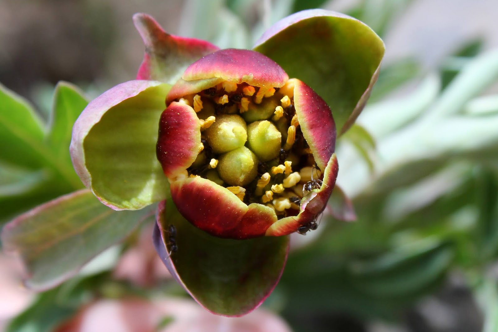
A waving plum of baneberry blooms
The first mile or so of the Lookout Mountain Trail angled uphill and while the day sort of wavered between overcast and sunny, the overall feel was muggy and warm. Naturally, I worked up a thirst but when I pulled on my drinking tube, a mix of mostly air and very little water came through. What the...? I KNOW I filled up my hydration bladder with water before driving to the trailhead, so some more nefarious force was at work here. I sat down on the trail and pulled my bladder out for further inspection. There was about a half-cup cup of water contained within but there was nary a sign of leakage, tear, hole or any other explanation of why I was out of water. Likewise, my pack was dry so it could not have dripped empty while stowed inside the pack. I mean, I just KNOW I filled it up at the campground this morning, but in the absence of any logical explanation for the parched desert that was now my hydration bladder, it must have been my fault again. But dammit, I KNOW I filled it!

The trail provided plenty of quality meadow time
At any rate, I needed to deal with the dry reality of my situation and figure out what to do with this hike. Currently I was in a shady forest and per my GPS, there were springs and creeks nearby. However, there are also abandoned mines nearby and hikers are warned to look and not touch the historical tunnels, buildings, and equipment lying around the vicinity. The reason for the warn-off has something to do with mercury poisoning. So, the first decision made was to avoid refilling from the creeks and springs running across the trail, I wasn't desperate enough to want to risk drinking mercury or any other heavy metals that may have been contained in the water. The second decision was to curtail the full loop hike and just to walk until I was out of water. The lesser decision involved with that was to nurse the remaining water and try to stretch out its lifetime and as a result, the amount of mileage I could get in on this hike.

A small ball of ballhead waterleaf
So, continuing on uphill through the forest it was, while I kept analyzing and reanalyzing the bladder mystery and replaying in my head in an endless loop, my filling up the water bladder this morning. The forest was a bit drier than what I'm customarily used to in the Cascades and the trees tended toward ponderosa pines instead of Douglas fir. However, the wildflower species were friendly and familiar, consisting of old friends such as larkspur, balsamroot, baneberry, star-flowered Solomon's seal, and paintbrush. Less familar were profuse quantities of a low-growing bluebell and balls of ballhead waterleaf, which has a rather unique habit of blooming in small globes at the base of the plant.

One of the larger meadows on the trail


The trail was at this point, angling up and across a forested ridge when the forest disappeared completely while the trail skirted a large meadow consisting of knee-high hellebore plants, a.k.a. corn lily, Off in the distance, were a series of higher mountains without any particular distinctive or dominant peak on the skyline, so we'll just call them by the rather generic term of Ochoco Mountains. I probably would have enjoyed the scene a lot more without the worry about water.

Just gotta love a level trail in sagebrush
Shortly after leaving the meadow behind, the path made a sharp switchback and attained the ridge crest. The back side of the crest was more like a plateau, although it did slope gently downhill away from the trail. Most of that forest I'd been hiking through was now gone, supplanted instead by dense growths of knee-high sagebrush punctuated with the occasional juniper tree. Wow, that was a sudden and abrupt change in vegetation, clime, and overall vibe! I briefly entertained a notion of walking to what I perceived to be the edge of the plateau so see what I could see, but the sagebrush stretched out for a half-mile from the trail or more and that would have been a whole lot of leg scratching as a result. Best to stay on trail, Richard.

Mount Jefferson looms ghostly on the skyline
Ah, the trail. All trails should be like this. The trail was flat and just sort of wandered aimlessly though the low brush, generally hugging the abrupt eastern rim of the plateau. So while I didn't get to see much to the west, openings on the east side provided views of the surrounding Ochoco Mountains. Can't diss the west-side view too much though, because snowy Mount Jefferson was visible throughout, with occasional glimpses of distant Mount Hood and the Three Sisters, depending on the orientation of the trail at that particular moment.

Western peony was yet another sign I was not in my Cascades


But really, this hike was all about the rock gardens atop the plateau, which was part of Lookout Mountain, if not the actual summit thereof. The clay soil had baked to the consistency of hardened rock and besides which, there was plenty of actual hardened rock strewn about too. The wildflowers were putting on an impressive multi-hued display, although a passing hiker told me that this was nothing, the flowers would "really" start blooming about two weeks hence.  

This balsamroot protected by guard spider
At any rate, serious hiking came to a screeching halt and a lot of my trail time was now spent lying prone on the ground, staring at wildflowers and insects through the viewfinder. As is customary during wildflower season, the blooms were well populated by buzzing bees, wasps, butterflies, moths, flies, and plenty of spiders eating and munching on said bees, wasps, butterflies, moths, and flies. 

Dwarf hesperochiron abounded in the rock gardens
Alas, I was now out of water, so I turned around at a muddy spring at a little over three miles in, and headed back the way I had come. Because I was getting thirsty (the lack of water becomes a mental condition, too) by the time I reached the cluster of trail junctions leading to some of the historical mines, I bypassed the mines and just charged downhill to the car, which had a jug of warm water in it waiting for me.

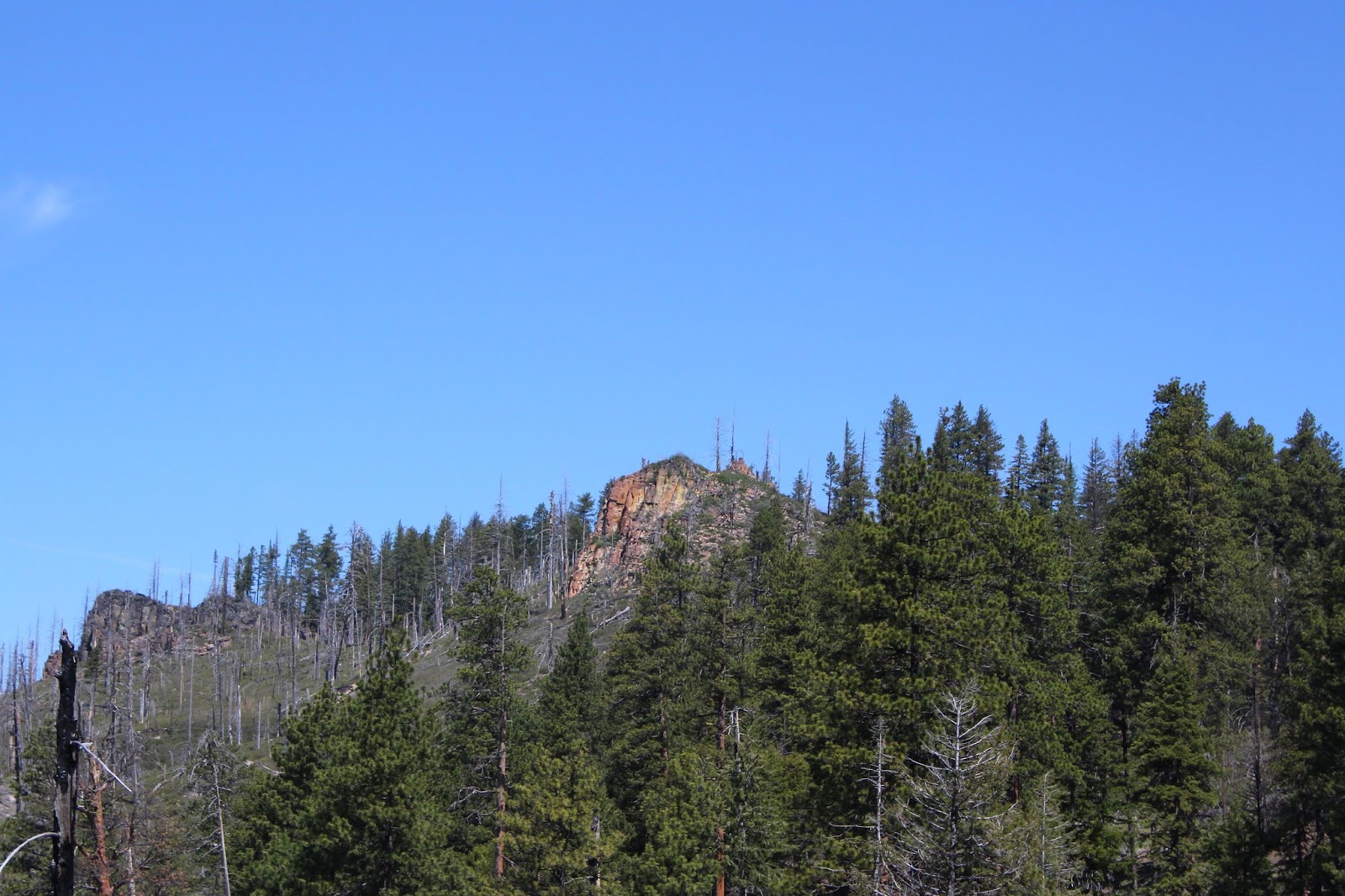
View to nearby Duncan Butte from the trail

When I arrived at the car and began divesting myself of some of my hiking equipment, the water mystery was solved. The back end of the Jeep was sopping wet, leading me to conclude that a suitcase or container of camping equipment had sat on the bite valve of the bladder, leading it to empty its liquid contents into the carpet. So, I'm still certifiably sane, I just knew I had filled it up!

A beetle in its tiny home
For more photos of this hike, please visit the Flickr album.


Tuesday, June 2, 2020

Twin Pillars

After several miles of hiking up and over a wooded ridge, Twin Pillars came into view through the trees. Yup, there were two pillars all right, but after hiking through the magnificent alpine meadows at Bingham Prairie, the twin towers just could not compare. In the end, they were just rock while the humongous meadows were world class scenery.

A lichen finds a home on the end of a branch
The Twin Pillars Trail basically bisects Mill Creek Wilderness, located in central Oregon's Ochoco Mountains, and this hike began at Bingham Prairie at the top end, meaning the hike would be basically downhill to the Pillars with the unfortunate opposite effect on the return to the trailhead. There is a primitive campground at Bingham Prairie but a wooden barrier in front of the campsites indicated the campground is currently closed. The road to the campground is also primitive, full of ruts, rocks, and deep water-filled potholes that made me cringe when I made the turn onto the "road", if you can dignify that mess by calling it a road. The "main road" to the campground turnoff wasn't much better, and I began to yearn for the civilized gravel roads of our Umpqua National Forest back home. My Jeep certainly got a workout today!

Bingham Prairie was as large as Maryland
Anyway, from the main road I hiked in to the campground and immediately got sidetracked by the grassy scenery. The meadows were huge, at least as big as two Portlands, consisting of acres and acres of luxuriant grass basking underneath a like amount of blue sky. There is just something about the green and blue color combination that inherently recalls some pleasant ancestral memory, tickling the fancy of the  brain's nucleus accumbens (the brain's pleasure center). Next time Mrs. O'Neill goes to visit family in Spokane, I'm having the living room redone with green shag carpet and deep blue walls and ceiling. Don't tell her that, though, it'll be a surprise! Actually, the real surprise would be if I did anything around the house, but I digress.

The trail passed through a series of meadows
Bingham Prairie and more specifically Bingham Springs, is where the small creek that carved out rugged and inhospitable Desolation Canyon enters into this world. The springs and moisture in the ground are what aids and abets the natural groundskeeping in the meadows, too. The first mile to a mile and a half of hiking wandered to and fro through a series of lush and verdant meadows and in my view, was the best part of this hike. 

Let's play Pick-Up Sticks!
In the year 2000, the Hash Rock Fire (a name which would appeal to certain high school friends of mine from a particular demographic) just scoured the hillsides clean of the forests that once flourished here before that impactful conflagration. Now, a forest of uniform six-foot high baby trees cover the hillsides, apart from small isolated knots of tall trees that survived the fire. Most of the snags have long since toppled over although a few still remain standing proud and upright here and there.  The new forest literally has to grow through a layer of dead trees to get to open air and sunlight.

Much of the route ambled through a new forest
From a hiking standpoint, it was kind of like walking in one of those garden hedge mazes, as I could not see any scenery, landmarks, or other points of interest while hiking in the new growth: just me, the trees, and a trail to follow. Periodically, near various forks of the Desolation Canyon creek, which shall remain nameless because it really has no name, the forest would thin out and the path would disappear into a boggy meadow, only to resume somewhere on the other side. Enterprising hikers had lain dead trees across the creeks as part of an ad hoc bridge system for getting past the creeks relatively dry-footed.

The lonely desolation of Desolation Canyon 
Eventually, the creek and trail parted ways. The creek went on to carve Desolation Canyon and the trail went to observe the creek's handiwork from the canyon rim. The topography of the canyon is extremely rugged, maybe even visually more so after the 2000 fire removed the trees and left just a deep canyon and craggy rimrock. No trail dares to enter this part of the Mill Creek Wilderness and it is easy to see why. I'm speculating here, but the inhospitable terrain probably aided and abetted the wildfire's spread and hindered the hard work of firefighting.

Peak 5682 fooled me into thinking
it might have been Twin Pillars
From Desolation Canyon, the trail continued up and over a ridge wooded with the ever ubiquitous baby forest. At the crest, the path entered a forest of large adult ponderosa pines that had survived the fire alive, but bore scars consisting of blackened trunks at the base of each tree. Partially visible through the trees to the west was craggy orangish colored Peak 5682, which I mistakenly thought might have been Twin Pillars, leaving me temporarrily wondering how I could ever get possibly closer without having to bushwhack through the dense pile of dead tree debris still covering the terrain. Fortunately, after a short on-trail descent through a tangle of forest fire debris, the tip of Twin Pillars decided to make itself known, appearing between trees both live and dead.

You just don't see larch on the west side of the Cascades
Speaking of trees, what manner of odd tree was I looking at? It was larch! Larch, an evergreen conifer that sheds its needles in winter, is not a denizen of southern Oregon. I didn't think it grew elsewhere in Oregon other than the higher reaches of the Columbia Gorge area and maybe the Wallowa Mountains tucked up in the remote northeastern corner of Oregon. Well, add the Ochoco Mountains to the list, for here was a small stand of the rare and seldom seen (by me, at least) tree.

Twin Pillars, in all its two-pronged glory
Also seldom seen by me is Twin Pillars, and I got a pretty good eyeful of the two rocky towers as the trail contoured around the base thereof. I think the taller pillar should be named "Arnold Schwarzzenegger" and the shorter pillar "Danny DeVito" which is a random reference to the movie "Twins", which deservedly did not win an Oscar that year.

The Mill Creek Wilderness also had its share of desolation
The Hash Rock Fire had done its worst here. I had been hiking through either a forest of baby trees, or old trees with blackened trunks. In either case, the fire scars were clear and obvious throughout the hike, being tattooed as it were, on the skin of the trees. But here, from a rocky overlook at the base of Twin Pillars, the rugged terrain of the Mill Creek Wilderness was on full display, for the wilderness had no clothes, so to speak. The hills had been and still are stripped bare, the roaring fire virtually denuding the terrain of any and all trees. There were a few lone survivors scattered on the hillsides but you could count them on one hand. White tree trunks, the skeletal remains of the once and former forest, were strewn pell-mell on the rough slopes throughout the wilderness area in accusatory testimony to the conflagration's savagery. Also in testament to the apocalyptic nature of the scenery, was a complete and utter dearth of any new trees to replace the old. Apparently the fire burned hot enough to cook all the seeds stored in what were ostensibly fire resistant pine cones. which would explain why the forest did not reseed itself in the years after the fire.

The trail skirts the edge of a large meadow

Despite the awesome devastation of the fire, the view of the Mill Creek Wilderness was stunning in its breadth and scope and well worth the labor to hike there. But, you can't stay all day unless you brought a backpack and I did not, so back up the forested ridge I went. At least the hike was uphill both ways! One good thing about hiking an out-and-back is you get to see the same awesome scenery all over again and accordingly, I repartook the desolate ambience of Desolation Canyon and the expansive meadows at Bingham Prairie. Life is good, and so was this hike in the Ochoco Mountains!

Hard to believe this small creek would
wind up carving out Desolation Canyon
For more pictures of this hike, please visit the Flickr album.