So I sort of volunteered Lane to lead a hike in Jacksonville Forest Park. Of course, the one drawback to my diabolical plan was that Lane had never been to the park and I'd been only once. Clearly a scouting trip was in order so Glenn, who is quite familiar with the park's network of trails, was enlisted to show us the way. But Lane called in sick, so it wound up just being me and Glenn, and we all see what Lane did there.
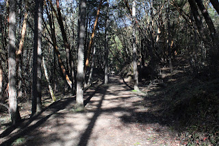 |
| The Rail Trail ambled through the pleasant woods |
Starting from the trailhead below smallish Jacksonville Reservoir, our route crossed the dam on a footbridge and set out on the Rail Trail. In short order, we arrived at the ruins of an actual railway trestle. Here, the bridge abruptly ended in mid-air and lest I be tempted to come up with a bunch of jokes about this, a plaque somberly reminded us that in 1917, one Denver Marsh perished in a train accident here.
 |
| Jackson Creek needs more water |
The Norling Trail ran next to Jackson Creek and to see the creek in its full glory, you need to be here right after a rainstorm (or during, maybe). On this day, the creek was barely trickling but the sound of water burbling through the trees was reward enough. At Confluence Bridge, where creeks Cantrell and Jackson meet, trails scatter in different directions like so many dandelion seeds floating in a breeze. Here, hikers have to decide in which direction they are going. For us, it would be a continuation on the Norling Trail up Jackson Creek. Norling is a popular name in the park as there is a road, creek, mine, and trail that all carry the name, the oddity being that the Norling Trail does not go to any of the other Norling-named features.
 |
| Norling Creek cuts a swath through leafy duff |
There were no falls on the Canyon Falls Trail either, although there was a bench that was labeled "Canyon Falls" that offered a look at lethargic Norling Creek desperately trying to make it as far as Jackson Creek before running dry. The hike was a steady uphill endeavor but never overly so, and offered a pleasant walk through woodlands carpeted with a thick layer of decomposing maple leaves.
 |
| Watch your step, the trail is icy! |
Small isolated snow patches flanked the trail, which was heavily frosted in places. Virtually all of this hike took place on the shady side of Jackson Creek's frigid canyon and even though the day was sunny, extra clothing layers were an all-day requirement, thanks to the chilly air and general all-around lack of sunlight on our route.
 |
| The entrance to Norling Mine was barred shut |
This park's history is heavily interwoven with historical mining activity around the rustic town of Jacksonville. Accordingly, our route sideswiped several mines, the first of which was Norling Mine. The mine entrance was just a small hole on a wooded slope, the entrance barred shut to prevent silly people from crawling into the mine and never being heard from again, or maybe to keep pallid cave deer from slithering out.
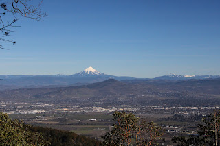 |
| View of Mt. McLaughlin and Bear Creek Valley |
The Atsahu Trail was on an old roadbed that angled upwards through woods increasingly trending to madrone before cresting at an open saddle. At the saddle, we made a hard right turn and Glenn gaily skipped up the path to Upper Twin Peak while I trudged step by painful step, darn younger people anyway. Our reward for all the toil and trouble was a rest on a strategically sited bench with an awesome view of Bear Creek Valley, Mount McLaughlin, and Grizzly Peak, all covered with white snow under a vibrantly blue sky.
 |
| No Richard, the hike was named after ME! |
It was all downhill from here, thankfully and we switchbacked down the Owl Hoot Trail, passing El Patron (a huge madrone tree) along the way. Hoot man, the downhill was certainly a lot more fun than the slog up Upper Twin Peak! The Owl Hoot met up with the Boulder Trail which in turn led to the Handsome Mine entrance, triggering a lively discussion between Glenn and I over which one of us the mine was named after. This mine was also doored shut, although a tap on a window pane turned on lights inside of the mine, illuminating railway tracks disappearing into the inky black bowels of the very earth itself.
 |
| Narrow trail in the deep and cold shade |
The Ol' Miner's Trail could have triggered another lively argument between Glenn and I but neither one of us had any real interest in claiming the moniker of Ol' Miner. If it were Handsome Ol' Miner, then maybe. At any rate, after wandering past an old hydraulic mine site littered with rusting mining equipment, the trail spit us out onto Jacksonville Reservoir Road near the trailhead parking lot and just like that, the hike was over. Many thanks to Glenn for helping us out with planning our upcoming hike.
 |
| Map of our route |
So, I ran into Lane a couple days later and let me tell you, he did not look sick at all. Far be it from me to say he pulled a fast one, but his recovery was a medical miracle on the face of it. However, since I am now the only one with knowledge of the route, I'll probably get stuck leading the hike for him but then again, I could call in sick!
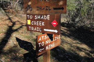 |
| Even the trails have trails |
For more photos of this hike, please visit the Flickr album.

Thanks for volunteering me to lead this hike, Richard 😒 Oh, by the way, I'm not feeling well, can you lead it for me? 😝
ReplyDeleteHey, you only get to pull that stunt just once! 😆
ReplyDelete