As many of you may have surmised from reading this blog, I do a lot of hiking. All those days, all those weekends, all those miles, and all those trails; they often blend into a mushpot of leftover memories. But then there are trails like
Burroughs Mountain Trail, a magical hike so transcendent it stands well apart from the rest, earning its own featured niche in my pantheon of most hallowed hikes. On a scale of 1 to 10, Burroughs Mountain rates at least a 57.
 |
The Burroughs Mountain crew
|
This was the second day of the annual Friends of the Umpqua camping trip (at
Mount Rainier National Park, this year) and we split forces as some of us wanted to drive farther to the
Sunrise area trailheads for the privilege of walking uphill on a rugged trail for approximately 12 miles. To be technically accurate, we didn't really start at Sunrise; we instead began the day's venture at Sunrise Point, nearly three hiking miles east of the visitor center at Sunrise.
 |
| Our view for most of 9 miles |
From Sunrise Point, mountains were everywhere, stretching out to the horizon where they lay in an indistinct jumble which we labeled with the rather general descriptor "The Cascade Mountains". Of course, the elephant in the room, mountain-wise, was Mount Rainier and virtually the entire hike would be done while staring right into the eyes of the massive glacier-covered volcano. We probably blinked first. Katsuaki had brought along 3 guests (Toru, Koki, and Aya) from Japan and while I don't speak Japanese, I could tell from the smiles on their faces afterwards, they did enjoy the hike. And along the lines of "the usual suspects," Edwin and Lane also came along.
 |
| Lane approaches Antler Peak |
Ron and Diana also came along ("sort of") but they intended to hike a shorter distance so while we laced up our boots in the parking lot, the two cheaters hitched a ride to Sunrise. It was easy to tell that Sourdough Ridge was not one of Rainier's premier hikes as it started out on a real trail with dirt and rocks and all that unpaved stuff. Almost immediately, Sourdough Ridge served up enjoyable vistas down Sunrise Creek's canyon and the high alpine basin of White River Park. Not so nice of a view was a trail directly ahead, climbing straight up the shoulders of Dege Peak without even a trace of a switchback to ease the grade. Hopefully, it wouldn't be our trail. Unfortunately, this was the latest installment of "Trail Designers Will Not Go To Heaven" as consternation gave way to sullen resignation as we surrendered to the inevitable and slogged up Dege Peak through a forest.
 |
| Huckleberry Basin, from Sourdough Ridge |
Once on the other side of Dege Peak, the trail contoured mostly grassy slopes with a grand view of the Sunrise complex and the surrounding grassy meadows of Yakima Park. Periodically, the trail would hit the ridge crest between mountains, proffering fantastic views of Huckleberry and Prospector Creek canyons running into the larger and deeper White River canyon. According to the map, there are trails that visit the alpine parks and valleys north of Sourdough Ridge and thanks to our all too brief peeks, these enticing trails are now on my very large and nearly endless list of trails I want to hike on. At any rate, we made plenty of camera stops due to the marvelous vistas on either side of the ridge crest.
 |
| Mountain goat on the trail to Frozen Lake |
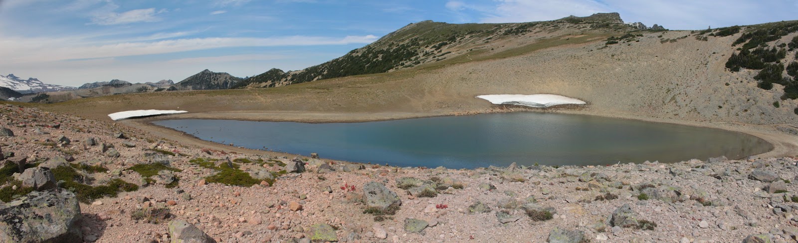
After about 3 miles or so, all the tourists, restaurants, and souvenir stores at Sunrise receded behind us as we continued to hike high up on the ridge crest. Shortly thereafter, the trees, grass, and wildflowers disappeared altogether when the trail contoured a slope made entirely out of rocks. We could see the trail hugging the steep slope all the way to a saddle between Burroughs Mountain and Mount Fremont. And just so I don't repeat myself, please silently add the phrase "...and there was an awesome view of Mount Rainier" after every sentence. Giddily scampering like mountain goats, we made short work of this wonderfully rocky and cliffy trail and sat down to eat lunch at Frozen Lake.
 |
| The not so frozen Frozen Lake |
Frozen Lake was no longer frozen, but there were a few small land bergs situated on the banks of the small lake. The lake was unscenically fenced off as it is the designated water supply for Sunrise, water tainting is strongly discouraged. Clearly, we had hiked above treeline as the terrain was all rocky tundra at this point. A chill wind blew and we all put on windbreakers or light jackets as we ate and rested.
 |
First &@#$%! climb up &@#$%! First Burroughs
|
After lunch, the "fun" started. The trail climbed relentlessly steep toward the summit of Burroughs Mountain. Actually, there are three Burroughs Mountain, each known by their ordinal number: First Burroughs Mountain, Second Burroughs Mountain, and Third Burroughs Mountain. I just found it easier to refer to them as First $@#$%! Climb, followed by Second @#$%&! Climb, and so on and so forth. Offering plenty of attitude and altitude, the trail had legs burning, hearts racing, and lungs huffing and puffing. It was totally awesome!
 |
| The Wonderland Trail, through a wonderland |
At least on the trail up the mountain, the views were absolutely fantastic. Of course, there was the obligatory glacier-clad Mount Rainier view as we neared the mountain. But below and away from the giant volcano, sprawled the rocky plain of Berkeley Park with the Wonderland Trail snaking its way through on the way to Skyscraper Pass. On the other side of the park was a jagged ridge crest culminating in Mount Fremont, with a clearly visible trail leading to the lookout on top. More trails for my list!
 |
| Second Burroughs Mountain is calling and we must go |
Eventually, the uphill stopped at First Burroughs summit and there was much rejoicing. We met Diana and Ron on First Burroughs as they were on their way down from Second Burroughs and because they had been, we now were forced to perform a second climb up to Second Burroughs, darn it. So it was lower the head and trudge on up another rocky path to Second Burroughs, a high point with a front row seat of the Mount Rainier show.
 |
| The White River's inception at Emmons Glacier |
By this time, clouds had scudded in and the weather felt slightly threatening. Light ribbons of clouds and mist wrapped themselves around the summit of Mount Rainer, imparting a decidedly mysterious and ethereal air about the mountain. The blue ice of Emmons Glacier was clearly visible along with all the crevasses that make glacier hiking so dangerous. And at the muddy and silty terminus of the glacier, White River sprung forth into its massive and glacier-carved canyon.
 |
Look but don't touch at Third Burroughs
|
Third Burroughs also called to us but it was much farther and higher than the distance between the first two Burroughs Mountains. We were already committed to a 12'ish mile hike without adding Third Burroughs to the trek, so we contented ourselves with watching a pair of hikers make slow progress on Third Burroughs, looking all the world like two small ants crossing a roadway. When I next return to Mount Rainier National Park, I'll do Third Burroughs from Sunrise to avoid the epic death march of a hike from Sourdough Ridge.
 |
Trail on the Burroughs Mountain rim
|
Anyway, after a protracted stay atop Second Burroughs, we returned back to First Burroughs and enjoyed the view to Berkeley Park all over again. However, this time we could see a herd of about 50 mountain goats relaxing next to a small pond well below. On the flat top of First Burroughs, we turned onto the loop route back to Sunrise. And after a short and level amble, the rough and rocky path dropped over the edge of First Burroughs and an already pretty awesome hike took it to the next level, attaining the rank of Most Hallowed at that point.
 |
| Most Hallowed |
A treeless and nearly sheer slope abruptly dropped 2,000 feet into the glacial valley of Emmons Glacier and the White River. Emmons Glacier impressed as it should, seeing how Emmons is the largest glacier in the lower 48. And glory of glories, our trail clung to the face of the slope like a tight tank top on a body builder's pecs. Glacial lakes, colored bright turquoise, dotted the floor of the canyon and were so new or so impermanent that they were not not even shown on the map. The wind was decidedly gusty and we had to hang on to our hats because there would be no retrieving them. And straight ahead, we stared down the chute of the White River canyon as the river seemingly carved up most of Washington. Not a hike for those sensitive to heights and exposure and you definitely want to watch your step here.
 |
| Edwin, on the return to Sunrise |
Where the Burroughs Mountain Trail met up with the Wonderland Trail, there was a rock-walled viewpoint where we all high-fived each other in appreciative triumph. Hikes just do not get any better than what we had just hiked and we all knew it. From there, the loop closed on what was now a comparatively humdrum path back to Sunrise. It was late in the day and we could clearly see our return trail gaining about 800 feet from Sunrise to Sourdough Ridge. We could also see Dege Mountain, the fourth mountain on the ridge, and regrettably our cars were on the far side of Dege Mountain. We still had a lot of hiking to do yet, but as I told Edwin "I can do it, but I don't want to". Everybody concurred, so Lane and Katsuaki hitched a ride back to the cars and then came back to pick up us lazy sloths eating ice cream sandwiches by the side of the road.
 |
| Stormy scene, at the end of the day |
For more pictures of this Most Hallowed Hike,
please visit the Flickr album.


Awesome! I hiked the trail from Sunrise to Frozen Lake when I was there in July. Definitely want to go back and hike Burroughs Mtn now that I've seen your photos!
ReplyDelete