Saturday, June 22, 2013

Northrup Canyon


Northrup Canyon


I just can't think of anything funny to say about Northrup Canyon, located in Washington's hilariously named Channeled Scablands. It's just too beautiful. This little treasure of a hike is located in Steamboat Rock State Park (some websites refer to Northrup Canyon State Park but the official Washington parks website does not have such a park listed) and while most visitors climb the rock or frolic in Banks Lake's waters, one is not likely to encounter a lot of fellow hikers in this isolated canyon. And Northrup Canyon provided a good excuse to escape from family in Spokane and get a hike in.
Green-banded mariposa lily, as big as Cleveland


The hits started virtually at the trailhead as the canyon was eminently visible as I laced up my boots, slapping at the mosquitoes as I did so. The red-brown canyon walls evoked memories of the canyonlands of southern Utah. Large, or I daresay huge, green-banded mariposa lilies flanked the trail. Obviously, I was out of my normal Cascade Range milieu and this hike, for me, tended towards the exotic.


Basalt formation on the canyon wall
Following a jeep road on the canyon floor, the route dropped down into a surprisingly lush aspen forest flanking the small trickle that was Northrup Creek. Flowers bloomed everywhere and camera addicted hikers make slow progress up the canyon. The jeep road passed through a series of lush meadows where rabbits scampered in panic at my arrival. The canyon walls and rock formations loomed overhead while nesting birds squawked at me from caves above.

Needs a little fixing up
At the last of several pastures, there are the ruins of several abandoned cabins marking the site of an old homestead belonging to the Northrup family that settled this canyon. A passing hiker told me park rangers used to live there years ago. However, the cabins are dilapidated and falling apart and well beyond being habitable, even for park rangers. A large pile of rusting tin cans showed where the garbage pit used to be.

Skyrockets in flight
The jeep road ended at the homestead site and from here on in, it was happy hiking on a real trail, a rocky footpath that headed up the canyon. The trail was an up and down affair with more ups than downs. The vegetation changed from green pastures to dry high desert sagebrush. Bright red skyrocket nodded over the trail while yellow was well represented by groundsel and golden yarrow.  Bugs crawled all over the flowers and it was slow going as I attempted to take a picture of every bug and every flower.

Northrup Lake
As the trail climbed, brief side trips took me to overlooks of the impressive canyon. Eventually, I ran out of canyon at Northrup Lake, a small pond at the canyon head. Not much to do but turn around and head back, completing a short but spectacular 6 mile round tripper while the sunlight faded.

Golf, anyone?

This is a classic hike in eastern Wasington, and I'll have to come back, maybe make Dollie come with me. I took a ton of pictures on this hike, you can see the chosen few (ha!) in my Flickr album.

Tuesday, June 18, 2013

Rogue River Trail

I received an email from friend Aaron who said "O Great One, please take me hiking so I can bask in your magnificence" He may dispute the veracity of that last statement but hey, it's my blog and I can write what I want to. The original itinerary was a hike to the summit of Devils Peak in the Seven Lakes basin but when lightning was added to the forecast, we changed the destination to the safer Rogue River Trail. We didn't want Aaron to get shocked (literally!) on his first Richard Hike. 

Aaron, on the Rogue River Trail
The Rogue River Trail is an old friend of mine and my boots seem to hit that particular trail at least once a year and it's a great place to introduce a newbie to the wonderful avocation that is hiking. Aaron, unlike past newbies, was in pretty decent shape and we made good progress as we quickly got up to the cliffs from the Graves Creek trailhead.

Deer, drinking in the entire Rogue River

One of the reasons I like this trail so much is that it spends so much time on the cliffs with the green waters of the Rogue River a hundred-ish feet below. As we approached Sanderson Island we observed a deer on the island's shore drinking water from the river. The deer drank and drank and drank for at least 30 minutes, or so it seemed. Impressed by the capacity of deer bladders, we continued on.

Let's get ready to ruuuuumble!

There was also an airborne commotion as an osprey and a buzzard were having quite the tussle. It was a mismatch as the osprey was all beak and talons and the buzzard could only taunt the osprey with a heartfelt but ineffective "I'll eat you when you are dead!"  The feathered imbroglio continued downstream in a whirl of feathers and avian shrieking, we have no idea what the outcome of the spat was but my money is on the osprey.

Graves Creek Rapids
The trail continued up and down alongside the river and we observed a multitude of rafts plying the currents. Poison oak nodded over the trail and we made sure to avoid touching the accursed plant. Hikers on the other side of the river made ant-like progress on the Rainie Falls Trail. And speaking of Rainie Falls, we could hear the waterfall's roar but not really get a good look at the falls from this side of the river.  

Mining equipment parts
After a little over 3 miles, we took the side trail to the historic Whiskey Creek Cabin and toured the old structure, taking in the mining equipment rusting in the grass, the old cans on the pantry wall, and the flume ditch running from Whisky Creek to Rogue River. Returning to the Rogue River, we walked another half-mile and lunched at park-like Big Slide Camp.

Aaron and Richard are going to get wet


On the way back, dark clouds came scudding over and the rain started. Aaron started to cry and once again, it's my blog and I can write what I want to. Thunder was rumbling nearby and we perhaps walked back a little bit quicker than we would have normally walked. Just as I was about to dig in my pack for rain gear, the rain let up and we were only mildly wet when we arrived at the trailhead.

Ancient petroglyphs
Fritillary frolic
For more pictures of this hike, please visit the Flickr album.

Saturday, June 15, 2013

Crack-in-the-Ground, Fort Rock, and Homestead Village

After 8 fun-filled days in the Oregon outback, it was time to go home.  So John, Merle and I tossed our gear and man funk (we hadn't showered in 8 days) into the car and began the journey home. Even though we were leaving, we had to get some last hikes in before returning to the unreal world.

Nature's plumber's crack
The first stop was at Crack-in-the-Ground, near Christmas Valley. Having been to Christmas Valley, I think it safe to say that Santa does not live there and the residents don't not look like elves or Santa's helpers.


John and Merle get cracking


Eons ago, four nearby cones erupted and covered the land with extensive lava flows. However, as the magma chamber emptied, the earth shrunk like a deflated balloon and the the ground sunk, causing a large crack to form in the hardened lava flow. The net result is a two mile crack with a trail at the bottom in what arguably is the largest plumber's crack in the world. The path is narrow and most times both walls can be touched with one arm span. It is not your hike if you are claustrophobic.


She did not make us feel welcome

When Merle, John, and I exited the crack, a hawk screeched at us in obvious irritation. She no doubt wanted us to keep away from her nest which was probably nearby. Horseflies also greeted us, but in bloodsucking joy with no distress. The only non-nest-related distress was that of victimized hikers.  

Fort Rock


Further down the road, we visited Fort Rock State Park. We had seen the iconic monument from Hager Mountain, Fort Rock was notable even from that distance. The fort is a volcanic crater that eroded over time, attaining it's current U-shaped form.  

Inside the crater
We did the short 1.5 mile hike in the crater's interior. John's hike might have been a little bit longer as he (illegally) angled to the cliff's base where ravens screeched and dive-bombed him. They get touchy when people get near their cliffy nests. We enjoyed close-up views of the crater rim with expansive views of the small town of Fort Rock and surrounding valley with Hager Mountain looming high in the distance.

Hallelujah!
Our last stop was in the small town of Fort Rock where we visited the Fort Rock Homestead Museum. Back in the late 1800's (and no, kids, I was not alive back then), homesteads were awarded to those who dreamed of owning their own land. Part of the requirements for keeping the homestead was that the homesteaders needed to farm the land and make it self-sufficient. Alas, the dry desert terrain was not conducive to good farming and most homesteaders rapidly went broke, losing everything they ever owned. Not a happy story in most cases. At any rate, some of the the old buildings from that era have been relocated to the museum grounds making the homesteader's financial ruin our happy gain.

Bye, vacation
Well, our vacation to the Oregon outback was over and we headed back to Roseburg for a joyous reunion with a shower nozzle.  Some of us had to to first reunite with a garden hose before being allowed inside the house. For more pictures of this travel day, please visit the following albums:

Crack-in-the-Ground

Fort Rock

Fort Rock Homestead Museum


Friday, June 14, 2013

Hager Mountain

So, after our Winter Ridge hike, we spent the afternoon huddled around a campfire while snow swirled around. The good news was that by the time evening rolled in, the snow-dropping clouds had broken up and we had no more issues with rain and/or snow. However, the cold stuck around and it was cold, cold, cold. I hadn't been checking the thermometer in the car but each morning we had ice encrusted on our tents; on this morning it was considerably colder and I decided to stay huddled at the bottom of my sleeping bag like a lump of coal in the toe of a Christmas stocking, and believe me, I would know about that.

Hager Mountain false summit
Fortunately, the weather gods showed us some mercy and the sun quickly warmed things up as we drove over to the Hager Mountain Trailhead. The trail headed up a gentle slope of pine trees with sunflower-like balsamroot blooming away in the shade. At the first switchback, we said goodbye to the gentle slope as the trail headed steeply up the slopes of Hager Mountain.

Up, up, up...
"Up" was the operative word as the vegetation transitioned from the relatively green balsamroot and grasses to the more familiar blue-gray of sagebrush. The flowers were putting on a show alongside the trail with the usual suspects: scarlet Indian Paintbrush, yellow balsamroot, blue flax, just to namedrop a few.

Mount Shasta, beyond Thompson Reservoir


The trees transitioned from tall pines to mountain mahogany, all stunted and misshapen like a novice hiker after a Richard Hike. As the trail inscribed long switchbacks to and fro, the views opened up.  Mount Shasta's snow cone rose up on the southwestern horizon above the blue and islanded waters of Thompson Reservoir. To the north, were the handful of buildings that is the small town of Silver Lake. A small horseshoe shaped rock formation beyond the town was famed Fort Rock. We could also see Crater Lake, Mount Thielsen, Tipsoo Peak, Diamond Peak, and the Three Sisters, all cherished and familiar hiking haunts for us. The entire geology was laid at our feet and one could see the path of the massive lava flows that eventually formed the Oregon we know and love today.


The Three Sisters


The views only improved the higher we climbed, and eventually the trail spit us out to a picnic table situated just underneath the lookout affixed on the summit. We paid a social visit to the resident lookout, a delightful woman by the name of Kathi, she'd been a lookout for several decades and she regaled us with tales of lightning strikes and bitter cold nights. In particular, while we were sitting around the campfire the night before, the same storm left about 6 inches of snow on the lookout while she actually slept in all her clothes, blankets, and even dish towels in a vain attempt to stay warm.

View on the way down
Unfortunately, we had to say goodbye to our new-found friend and head back down the trail. On the way down, we got to enjoy the flowers and views all over again; perhaps even more so as we didn't have to labor up the mountain. And the good news was that it was warm that night, it was a confirmed and balmy 27 degrees the following morning.
Hager Mountain panorama

For more pictures of this hike, please visit the Flickr album.


Thursday, June 13, 2013

Winter Ridge

Winter Ridge is appropriately named, based on our experience there. The night temp had dipped into the high 20's and I spent the night huddling inside my sleeping bag, curling myself into the smallest human ball possible just to keep warm. But hey, that's what morning campfires are for and John and Merle had fired one up and we huddled round the fire until the sun came up.

Merle and John search for a trail

Winter Ridge is accessed by the John C. Fremont National Recreation Trail and sadly, the trail was in poor shape. Beetles had killed a lot of the trees in the forest and dead trees have a tendency to topple over and lay across a trail. One tree, no problem; many trees, and the trail tends to disappear and that was the state of things. At one point we lost the trail altogether but not to worry, all we had to do is keep the Winter Ridge dropoff on our right and we could make slow progress along the ridge.

My loyal followers
Perseverance provides rewards and we were rewarded by a faint trail tread with a minimum of trees on top of it about a mile into the hike. After passing through a gate the trail left the ridge crest and headed downhill through a series of meadows flanked by picturesque Ponderosa pines and quaking aspens. Unbeknownst to us  at the time, we had again lost the Fremont Trail and we were on a side trip to Currier Springs.

Hiker trough at Currier Springs
Currier Springs is a highly developed trailhead for the horse riding crowd, what with stout corrals and the spring waters being piped into a series of horse troughs.  All this while us hikers had not even a trail to hike on. I'd say lucky horses, but then again I don't have to carry anybody with spurs on my back, either, unless it's for fun.  And it's not fun. Well, not to me, anyway. Can someone help me get out of this paragraph?

Follow the cairns
At any rate, a short half-mile trail took us back to the Fremont Trail from Currier Springs and we were back in business, sort of. It was the same old faint trail on the ridge but fortunately a series of waist-high cairns marked the way like a yellow brick road for hikers.  

Great views of Summer Lake were a constant


Periodically, we would bushwhack to the edge of Winter Ridge and soak in the view of Summer Lake, a dizzying 3,000 feet below. John Fremont  had explored this area and also dropped down to the lake without benefit of a forest road or established trail. They were a pretty hardy bunch, in those days.
Uh oh, here comes the snow

There was a prominent point that was the logical place to turn around at but there was talk among us about continuing on further along the rim. However, just as we started to struggle through the low growing brush on the point, clouds came in and covered up the blue sky. A wall of belligerent storm system was scudding across Summer Lake, kicking up dust storms in front. Much to our surprise and consternation, the air was soon swirling with small snow flakes. There was no more talk of continuing on further.

A wintry Summer Lake
So we methodically worked our way back along the ridge in the snow storm. We did follow the Fremont Trail along the section we had strayed from, I'm not sure how we missed it because the tread was fairly easy to follow on the return leg. I do know how Merle and John missed the trail: they had simply followed me when I made the wrong turn. After the tedious slog in the last mile of fallen trees we returned to our campsite along Rock Creek.

John sleeps and dreams of dancing elves
The rest of the day was spent huddled around a large campfire, telling stories and anecdotes while snow swirled around. The snow was not sticking so despite the elements, it was a most enjoyable to spend the day. By the late afternoon, the clouds dissipated as we headed into a very cold night. That was not so much fun.

The beginning of a very cold night
For more pictures of this hike please visit the Flickr album.

Wednesday, June 12, 2013

Travel Day

Sad but true, it was time to say good-bye to Hart Mountain Antelope Refuge. Our visit was just temporary, I think only the antelope get to stay there on a year round basis. Merle, John, and I piled into the car and headed towards the Summer Lake area in south-central Oregon.

Don't drink the water at Abert Lake


After a breakfast in Lakeport of real food that was not reconstituted over my Jet-Boiler, we headed north and stopped at Abert Lake. In this area of Oregon, seismic processes have uplifted huge blocks of land; Hart Mountain is a prime example of one of these upliftings. Eons ago, huge Lake Chewaucan covered this area but over time the waters receded. Because the lake basin had and has no outlet, minerals and salts  have accumulated, leaving behind a series of alkali lakes. Abert Lake is one of these.

Abert Lake panorama
Abert Lake is flanked by a tall 1,500 foot high escarpment, typical of this area.  The waters are alkali so the lake is undeveloped and the remoteness assures little visitors to the toxic lake. Life does thrive in the waters, however, in the form of brine shrimp which have adopted to the strange brew in Abert Lake. Because of the shrimp, the lake is a haven for birds who feed on the shrimp while drinking water from the freshwater tributary creeks. You can eat the shrimp but don't drink the water.

A sign we are not in Roseburg any more
Apparently bighorn sheep hang out on the escarpment face but even though we stared hard at the cliff, we did not see any. There was a highway sign warning of bighorn sheep crossing, so much for being "ram tough".

Summer Lake
We continued on to Abert Lake's relative, Summer Lake.  Summer Lake also has its origins in Lake Chewaucan's demise, making lakes Abert and Summer kissing cousins of sorts. Summer Lake, because of the prevailing winds, has accumulated a large tract of sand dunes on east side.  

Summer Lake panorama
After snapping some pictures of Summer Lake, we continued on up the west side escarpment known as Winter Ridge. Winter Ridge was named by John Fremont as it was snowy when he explored the area. Working his way down the escarpment (without the benefit of a gravel road), his party arrived at the alkali lake.  "Ooh, first it's cold, then it's hot" he said. Actually that sounds like something I would say, but the end result is that the lake was named Summer Lake.

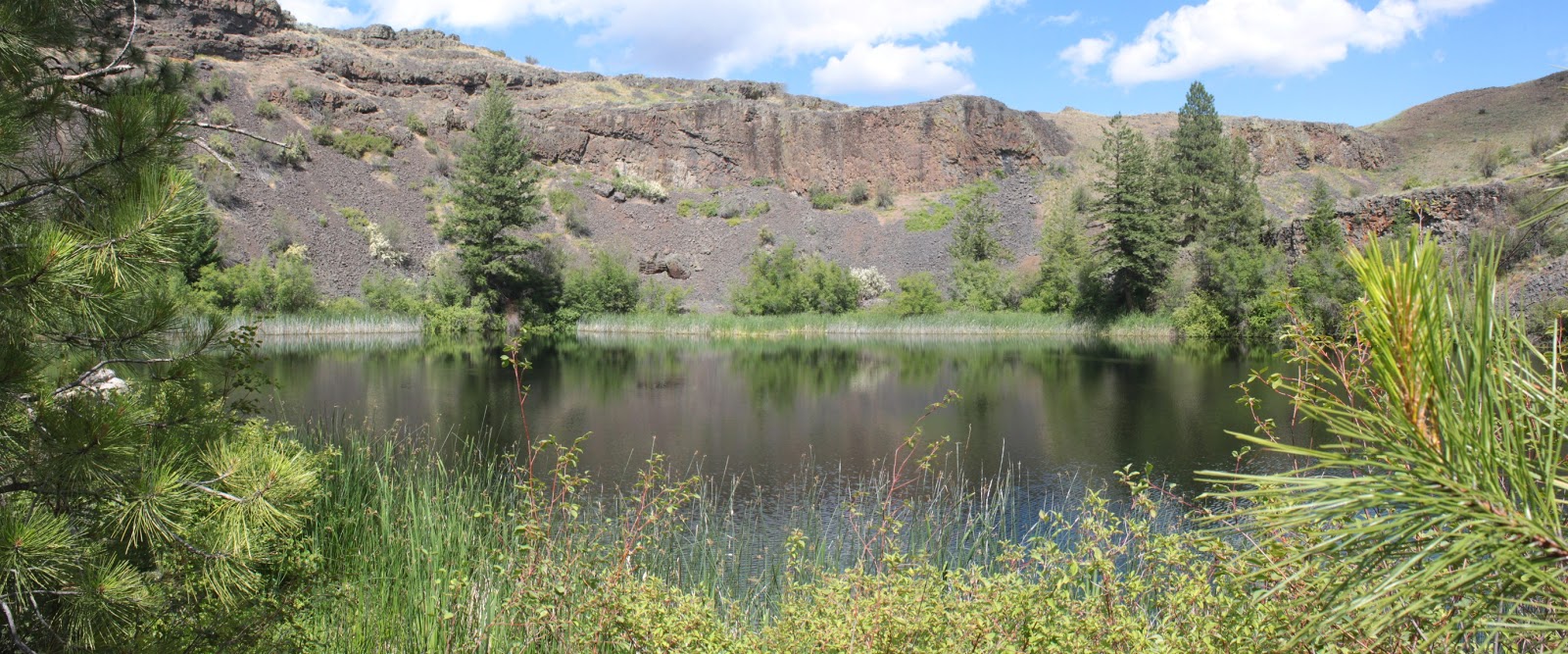
Our home for the next three nights
Rock Creek Campground, on top of Winter Ridge's broad plateau, would be our home for the next three nights. The road into the campground was extremely rough and I uttered a "Forgive me Dollie, for I am about to sin" each time I drove her car on the rocky track.  

Our nightly ritual
The forest here has been decimated by beetles and the dead trees had been cut down, making for an abundant supply of readily available firewood. Since the nightly temperatures dipped into the 20's during our stay, we enjoyed some rather robust campfires.

Pretty but way cold


So, that's it for this brief travelogue, you can visit the Flickr album for more pictures of our relocation from Hart Mountain to Winter Ridge.

Tuesday, June 11, 2013

Barnhardi Basin

Ah, Hart Mountain Antelope Refuge is so beautiful. Wide open spaces that go on forever with enough tall mountains to keep little hikers with big egos relatively humble. Later in the year when the sun bakes the refuge hot and dry like a bachelor baking a pot roast for the first time, the refuge is probably not as hospitable as it was during our stay here. We hated to leave but leave we must so we saved the best hike for last: a pleasant stroll into the green dale of Barnhardi Basin.

Merle, at an early morning start to the hike
On the plus side, getting to the trailhead required no driving as the Barnhardi Road began at the hot springs in our campground. Not wanting to get pulled into a conversation with "The Naked Guy" frequenting the hot springs, we averted our eyes and walked quickly past. The trail, actually a jeep road, followed Rock Creek for a while before peeling away and heading uphill alongside a small fork of Rock Creek.  

Cold and cloudy Warner Peak
The skies were gray and overcast and a blustery wind kept things cool and perfect for hiking. The creek burbled merrily as a dense stand of white-barked aspen kept the stream hidden from view. Not so perfect, however, was the grade as the road climbed relentlessly up the sagebrush-covered slopes of Hart Mountain.  It's trails like these that get me muttering to myself "I need a new hobby" and "I hate hiking". However, the grade ended at a ridge crest with a nice view of cloud-bound Warner Mountain. It's trails like these that get me muttering "I'm glad I have this hobby" and "I love hiking".

Foolhardi 
Barnhardi Basin is a green meadow right below Warner Peak, and we splish-splashed through the wet grass to the Barnhardi Cabin. An old homestead cabin, the shack is pretty dilapidated with a sagging roof and floor. There are not enough Martha Stewart doilies in the world to make this ramshackle cabin a habitable home, even with the world class view from the front door.

Water in the desert
Well, we had reached our destination but had not walked yet very far and it was decision time. We could have returned cross country through the narrow cleft of Rock Creek or we could follow the Barnhardi Road and see what there was to see. We chose the up-and-down latter option. Amazingly for this area, a genuine bona fide creek crossed the trail and the vegetation was lush and verdant. So many flowers blooming by the wayside and I soon lagged behind, a camera-happy fool.

Buzz! Hah, scared you!
At the 4 mile mark, I turned around, content with a respectable 8 mile hike. John and Merle continued on and I enjoyed a leisurely return, taking pictures of all the desert flowers we never see on the west side of the Cascades. The terrain was abuzz with the love songs of the cicadas. The critters were flying all over the trail and if hikers stepped too close, they buzzed a warning like a rattlesnake would. I was a nervous wreck by the time the hike ended.

Pellet pusher
At one point, I was looking at a pile of deer poop when a pooplet or pellet or whatever you call an individual piece of the pile began rolling around seemingly possessed by a poo-poo poltergeist. Upon closer inspection, there was no supernatural explanation needed, it was simply a handstanding dung beetle rolling his treasure with his back legs. I'd never seen one before and now I'll have to give extra scrutiny to deer poop piles. And, I wonder why I have no friends.

Aaaaah....
At the bottom of the trail, there was a primitive hot springs that burped sulphurous gas bubbles (just like my brother) in the clear water. I removed my shoes and soaked my feet in the hot water, as happy as a purring cat. We definitely saved the best for the last!

Bye, Hart Mountain
For more pictures of this hike, please visit the Flickr album.