Showing posts with label ashland. Show all posts

Friday, May 14, 2021

PCT (West from Soda Mountain TH to livestock pond)


Some niggling little health problems (I'm fine, thanks for asking!) predestined this overnight backpack trip in the Cascade-Siskiyou National Monument to be a short one. However, despite the diminutive mileage, this hike was big in forests, scenery, and hugely epic (but not in a good way) when it came to weather conditions. Still, two out of three is a passing grade and I could have always stayed home to file my crusty old toenails. 

Look, a hiker, let's get him!

When I hoisted my backpack onto my shoulders at the trailhead, the sky was blue, the temps were mild, and all was bathed in bright sunlight despite a looming bank of baby thunderhead clouds parked several safe miles to the east. Perfect conditions for hiking in and you'd never suspect bad weather could become an issue on this hike, but such is Oregon weather and keep on reading, dear readers of mine.

Not all the snow had yet melted off

May is, in my humble opinion, the optimal time to visit the Cascade-Siskiyou National Monument. The small mountain range of the Monument bridges the gap between the Siskiyous and Cascades mountain ranges and the whole vibe is at turns, either or neither or both Cascade and Siskiyou in terms of vegetation, climate, and geology. In about a month or so, the terrain will brown out due to the aridity of the area, the dried out hellebore meadows then rattling in the summer breeze like thousands of cackling witches. But in May, the snows have not completely melted, the forests are damp, the mountains are cloaked in a green blanket of lush vegetation, and wildflowers put on a show for camera-toting backpackers.

After the storm

The Pacific Crest Trail bisects the Soda Mountain Wilderness, a wilderness preserve set within the Monument's boundary. In the Wilderness, the forest was cool, dark, and shady while a virtual army of marching trilliums bloomed on the forest floor, if thousands of elegant flowers could be accurately described as a marching army. Maybe that's not an apt descriptor but it would not be the first time I babbled or dabbled in inept metaphors. At any rate, there were lots of white trilliums blooming, with bluish Oregon anemone and nodding glacier lilies playing a significant supporting role.

Avalanche lilies were everywhere

Periodically, the trail would break out of the forest and onto open slopes that tended to be somewhat on the rocky side. On either side of the trail sprawled huge meadows with nubs of sprouting hellebore being just a few inches tall. A byproduct of the open meadows or rocky slopes were expansive views of Bear Creek Valley with Mount Ashland dominating the skyline and crest of the Siskiyou Mountains. Snow had been here until just recently, evidenced by the sprouting hellebore and rampant patches of avalanche lilies, the dangling star-shaped flowers pointing face-down toward the ground, which was still wet and muddy thanks to the recently thawed snow.

The water pond and yes, I drank the water


In one of the meadows, there is a small livestock pond that is an important water source for PCT hikers as water gets to be in very short supply in August, when the through-hikers pass through Oregon on their way to Canada. Camping near the pond was a little problematic because the soil was wet and mushy during my initial search for a camping spot. However, a long and broad meadow extended north and I set up camp on the meadow's edge, with an awesome view of the valleys and mountains dropping and rising from my campsite as my reward.

Larkspur inhabited the meadows, too

The low grasses were chock full of short flowers, notably those of larkspur and the ever plentiful avalanche lily. When not crawling on my hands and knees in my never-ending quest for the perfect wildflower photo, I spent time at the edge of the meadow, admiring the view as the day waned into late afternoon. But clouds rolled in overhead and the day went dark while a gusty breeze began to shake trees and tent alike. Yet, looking north and west, Medford, Ashland, and Mount Ashland were enjoying a sunny day while I was having to unfairly contend with ever increasingly belligerent weather.

Rain cometh, it has been foretold

The weather continued to turn and the light clouds turned as dark and oppressive as a pessimist in a bad mood. The breeze increased in velocity and I was having to restake my tent every now and then as bellicose air currents worked the stakes loose from the very soft soils of the meadow. Soon a nonstop pitter-patter of raindrops on my hat brim announced the change from intermittent shower to out-and-out rain. Yet, the sky to the north was tinting yellow and orange as sunset drew nigh while I was stuck on my meadow having to endure the elements.

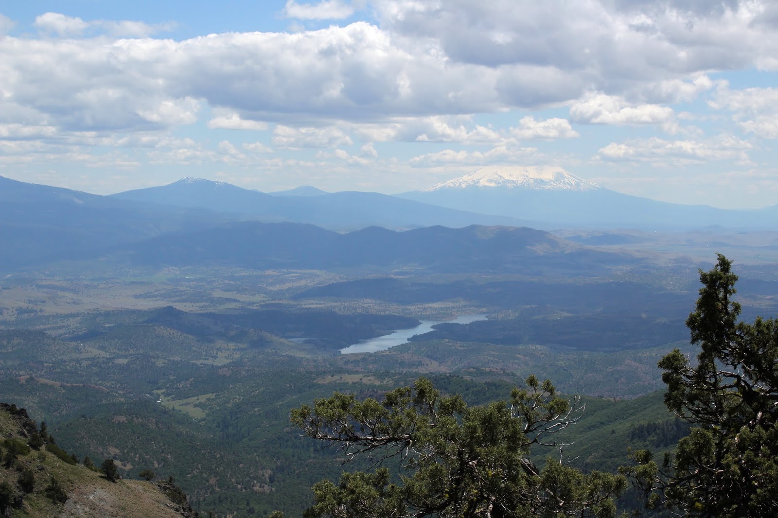
Strange weather over Emigrant Lake

Tired of getting wet, I retired early, listening to the soothing sound of rain on my tent. Not so soothing however, was the rumble of distant thunder. In short order, I could see flashes of lightning and discerned the lightning was fairly far away, for I could count up to five before the thunder arrived. Pretty soon though, I couldn't even count up to one and if I closed my eyes, I could see the veins in my eyelids every time the lightning flashed. And that thunder was loud too, each boom starting in the left ear and finishing in the right like an Airbus A380 from Hell dive-bombing my puny tent from east to west.

Sunset at the same time as the hail
storm was pummeling my tent

The staccato noise of the rain on my tent fly suddenly changed in tenor and intensity. Those raindrops were now fat and heavy and I stuck my head outside of my tent to see the latest weather wonder. What fresh new Hell was this? Instead of rain, my tent was being pelted by heaviest hailstorm ever. I almost said "Well, at least it's not large-sized hail!" but managed to catch myself before that thought was uttered out loud. Because the wind insisted on working my tent stakes loose, the tent's roofline sagged a bit and the hail began collecting in the dip. Removing hail off of the tent was added to my list of weather-related duties. Yet, while hail accumulated on and around the tent, light from a beautiful sunset over Mount Ashland was slanting into my eyes. Weird.

The next day was like "Rainstorm? Lightning? Hail? Really?"

The hail lasted about an hour and a half and the whole storm about five hours in duration. But eventually and for no reason at all, all went quiet as if the Supreme Storm Master had capriciously flipped the "OFF" switch just because she could. The peace and quiet were most welcome and I then fell into a relaxing slumber that was probably more exhausted stupor than sleep. The next day dawned bright and near cloudless, making for a nice and easy hike out while at the same time, reminding me I had definitely picked the wrong evening for my first backpack trip this year. 

Right outside my tent door

For more photos of this hike, please visit the Flickr album.

Tuesday, June 30, 2020

Grizzly Peak

Let's raise our hiking poles in revererntial homage to the memory of Old Reelfoot, a notoriously crafty grizzly bear that terrorized cattle and stockmen in southern Oregon in the mid-1800s. Because of a paw injured by a bear trap, his unique footprint distinguished him from all the other grizzlies hanging around the Siskiyou Mountains and because he managed to elude hunters for so long, he became somewhat of a local legend. His range was mostly in the Pilot Rock area although he made many a hunting foray down into California, making him a wanted bear in two states. He had a good run but in 1890, time ran out for the elusive bear and he was finally hunted down and killed. Posthumously, he enjoyed a brief career as a stuffed and mounted touring exhibit in various museums, expositions, and fairs in the nation, although maybe "enjoyed" might be the wrong word here.

Every time skyrocket blooms, a retina dies


Anyway, in Old Reelfoot's honor, a smallish mountain near Ashland was given the name Grizzly Peak which coincidentally enough is the subject matter of today's blog missive. Grizzly Peak is a short hike, totally incommensurate with Old Reelfoot's fame as a terror of the Siskiyous but on the other hand, I'd hate to run into a grizzly on the trail, no matter the mileage of the hike involved. Deer are scary enough, never mind the bears.

It's a jungle out there!


Because it's a long drive for a short hike from Roseburg, I don't do this hike very often. In fact, this was only the second time I'd ever been to Grizzly Peak. Medford buddies Glen and Carol exposed me to this spectacular hike several years ago and while I was impressed then, I think I was even more appreciative of the rugged beauty this time out as the vegetation was a lot more lush than on my first visit, and that's the difference between hiking on Grizzly Peak in early summer instead of late spring.

But where are the poison oak and ticks?
The trail wasted no time heading uphill at a moderately brisk rate and the first thing I noticed was the lushness of the forest undergrowth. It was a veritable jungle underneath the tall trees what with all manner of plant specie, from tall delphinium to lowly wild ginger, flourishing in riotous exuberance. Orange columbine nodded next to the trail, their dangling tassels reminding me of a graduate's mortarboard. There were so many flowers, like thimbleberry and larkspur, just to namedrop a couple. All this and I hadn't even reached the meadows yet, where the real flower show would take place. Needless to say, my pace was relaxed and slow as I enjoyed the shady trail and wildflower display.

Alien-looking cow parsnip bud
This trail sees a lot of use because of its proximity to Ashland and Medford, and because of its relatively short length. Accordingly, the trail was wide and well kept, almost like a park path. For someone like myself accustomed to scrambling over fallen trees and wading through poison oak bushes, the civilized nature of the trail was most refreshing. 

The ever present Columbia windflower


The actual summit of Grizzly Peak is rather underwhelming, to say the least, looking like a rocky cairn in a sparse meadow surrounded by tall trees. No view, no epic barehanded scramble to the top, no sir. But then again, this hike is all about the meadows, at least immediately after the summit. The pattern for the next mile or so was to walk through alternating low-growing grassy meadows and lushly shaded forest carpeted with thick patches of candy flower. 

An ornate checkered beetle on a fleabane
In the meadows, much photography ensued, for the meadow were chock full of salsify (among many other flowering species), a yellowish sunflowerish bloom attracting a multitude of bees and butterflies. Not to be outdone were salmon polemenium (a salmon-colored Jacob's ladder), mountain-owl clover, sulphur flower, and patches of skyrocket, the brightest colored flower ever. As the trail looped around the broad and flat summit of Grizzly Peak, views of the surrounding terrain awed as they appeared through breaks in the forest cover in a taste of things to come. Although clouds took away the view of nearby Mount McLaughlin and the distant Three Sisters, I spotted Mount Thielsen, Union Peak, and the collective peaks adorning Crater Lake's rim to the northeast of Grizzly Peak.

The trail went through a series of meadows
In 2002, a wildfire started by a sparking power line raged on the west side of Grizzly Peak and nobody really cared, because Oregon's collective attention at the time was focused on the massive Biscuit Fire. The fire here on Grizzly Peak must have burned fairly hot because during the subsequent decades, a forest has yet to return to the western slopes. However, Grizzly's arboreal loss is our hiking gain, for the views here are simply astounding.

That little pimple is Roxy Ann Peak,
overlooking the city of Medford
The hike's flavor transitioned from parklike stroll through the meadows to rugged goat track on the edge of a rocky ridge. Below the rough trail was a lesser mountain which was basically an extension of a west-side ridge of Grizzly Peak. This "little" high point dominated the near view, its rocky ridge and acres of ghostly white snags commanding our attention and respect. The ridge continued north in a series of subsequent high points, culminating in the cone of Roxy Ann Peak, looking puny from here. As an aside, Roxy Ann Peak does not look so puny when hiking up to its summit.

Quite the view of Bear Creek Valley
Beyond Roxy Ann Peak was the wide Rogue Valley with Upper and Lower Table Rocks eminently visible at the edge of the valley. Immediately to the west was deep Bear Creek Valley with the towns of Ashland, Talent, and Phoenix all safely ensconced within. The Lord of all Mountains to the South, a.k.a. Mount Shasta, rose up like the awesome snow-covered volcano it is, while local landmarks Emigrant Lake and Pilot Rock were dwarfed by the giant cone rising over all. 

A bee gets a pollen bath
This was and is my favorite part of the hike. The topography is rugged, the views astound, and on a late June day, the flowers and insects put on a show in the low meadows thriving in the old burn zone. Balsamroot, golden yarrow, common yarrow, and bright red paintbrush were all in full spring song and the winged set of insects such as bees, wasps, hoverflies, butterflies, and moths all flitted and buzzed from flower to flower. Longhorn flower beetles and other horny beetle species waded in the pollen as they fed and frolicked in and on the numerous blooms, and not necessarily in that order. On bare ground baked hard by the sun, dwarf onions waved pink and purple flower pom-poms at the blue sky overhead.

Dwarf onion thrived in the hard, dry soils


The trail crested at a craggy overlook atop the high point of this trail and was a perfect place to eat lunch, sit, admire the view, and generally just ponder the meaning of life or go to whatever happy place your thoughts may take you to. After a totally enjoyable lunch 'n laze, I gathered up my stuff and continued hiking. The path returned to the familiar pattern of meadow to forest to meadow before closing the loop and bringing this short, but totally epic hike to an end.

A salsify captures a hoverfly's attention
Looking at the map of this hike, I noticed that to the north, Antelope Creek does a flow-by of Grizzly Peak. That would be appropriate because what's in my head (which is not always accurate) is that the 2002 fire was called the Antelope, or maybe the West Antelope Fire. However, my copious Internet research performed for this blog post failed to confirm my suppositions one way or another. Also, I searched for anecdotes about Old Prong Horn, the feared antelope scourge of the early pioneers of the Rogue Valley and yes, I'm making that up. Since antelopes live in the southern Oregon desert on the east side of the Cascades, naturally there would be no lore about fierce antelope living on Grizzly Peak, although they could have given Old Reelfoot a literal run for his money.

Oregon geranium was locally common in the burn zone
Fore more photos of this hike, please visit the Flickr album.


Friday, May 18, 2018

Boccard Point

Just had to go get me some Cascade-Siskiyou National Monument! I love this place and really, spring is the time to go as the dry summer climate can brown out hills and meadows fairly early in the year. Ah, but in spring, meadows are green and lush, the shady forest is burgeoning with spring growth, and erstwhile arid barrens sport colorful rock gardens. Regrettably, this beautiful jewel in the National Monument system is currently on the chopping block, thanks to a misguided president who does not hike. It really would be a shame to ruin this wilderness with logging, grazing, and motorcycles.

Dangling gooseberry


Brad is slated to lead a Friends of the Umpqua hike here in June and he didn't know Boccard Point from a bagel. Naturally, that would bring into question his leadership abilities: knowing where you are going does tend to automatically impart an air of confidence and competence. Richard to the rescue, though! I was enlisted to show him the way ahead of the official hike, and I only too gladly obliged, seeing how this wilderness is one of my favorite hiking haunts.

Dwarf hesperochiron ruled dry soils
We couldn't have picked a better day. It had rained the evening before but we began hiking under a gloriously blue sky. Despite the ample sun, the temperatures were fairly mild and the forest had that whole post-rain moistness thing going on. Leaving the Hobart Bluff Trailhead, the Pacific Crest Trail (PCT) ambled under some power lines right at the start and entered an arid field. Despite the dryness in the open and rocky soil, phlox, larkspur, and thousands of dwarf hesperochirons were coloring up the rocky barren. We hadn't walked even a quarter-mile and already, I was crawling on my hands and knees, photographically cataloging every wildflower specie thriving in the small barren. Welcome to "Hiking with Richard", Brad!

Trillium dominated the shady forest


One of the things I particularly enjoy about this stretch of the PCT is that the scenery alternates stark hardscrabble with verdant forests and meadows. It's like a patchwork quilt of contrary macro-ecologies. So, after the hands-and-knees photo-shoot of low-growing wildflowers, we followed the PCT into a wonderfully shaded forest with elegant and stately trillium blooming in profuse rampantness (Rampitude? Rampantenacity? Rampantage?). 

Meadow...'nuff said!
Once past the intersection with the Soda Mountain Trail, the PCT leapfrogged from meadow to meadow, all colored bright green under an equally bright blue sky. There is just something about blue and green that is inherently pleasing to the eye. We were hiking on the Cascade-Siskiyou crest and and enjoyed constant and great views down Bear Creek Valley, Ashland, Medford, and the Siskiyou Mountains near Mount Ashland. 

The venerable Pacific Crest Trail
The trail had been remarkably level for the first several miles but then it plunged for a mile or so, losing elevation at an alarming rate, considering we would have to gain it all back on the return leg. The mile-long descent ended at a jeep-road/trailhead combo and that was our cue to leave the PCT and follow the faint path to Boccard Point.

Sketchy path near Boccard Point
Before losing all that elevation, we had a pretty close sideswipe view of Boccard Point but the PCT had continued on past the point for the aforementioned mile of downhill walking. Now, the Boccard Point Trail doubled back below the PCT and gained all the lost elevation and distance back, with the same deleterious effects on the way out. Trail designers are sadistic demons, there is no other way to explain the route.

Trail, barely visible atop Boccard Point
While faint and sketchy, the path followed an old roadbed so the route was easy to follow as it angled gently and steadily for the two miles leading up to Boccard Point. The day had warmed up considerably from our cool start, and we were feeling the sun on the open roadbed. Finally, the trail leveled out in shady forest atop Boccard Point and we ate lunch on a small promontory.

You can see California from here!
Lunch always tastes better when spiced up with a view, and this lunch was delicious. To the west, Pilot Rock was the nearest neighboring peak, it's silhouette backdropped by the slightly snow-covered Siskiyou Mountains. But it was the view to the south commanding our rapt attention. The Cascade-Siskiyou mountain range dropped at our feet and Irongate Reservoir glistened in the afternoon sunlight. Mount Shasta, its snowy tip hidden by clouds, rose up on the opposite of the Shasta Valley.  Bowing down at Mount Shasta's feet like a devoted disciple, Black Butte displayed the reverence that is only proper when in the presence of greatness. To the west of Shasta was Mount Eddy and the rest of his Scott Mountain friends. It was amazing to consider the very same PCT we had hiked on today, also traverses Mount Eddy in the far distance

Brad-fu
The view was epic and eminently enjoyable and besides which, us Oregonians derive a certain smug satisfaction from looking down our noses on California, both literally and metaphorically. The magnificent scenery just compelled us to act like the idiots we are, so I broke out my "Running Man" pose while Brad busted some sword-fu fighter move which he called "The Brad".

The tip of Mount McLaughlin, from the PCT


All that re-gaining of lost elevation was not fun and I was pooped by the time the PCT crested a mile or so west of Soda Mountain. But fortunately, the trail was level from there on in. The act of taking a photograph is the last refuge of a tired hiker, and more pictures were amassed as this 10 mile hike came to a close. Despite the fatigue, I still remain madly, deeply, and truly in love with the Cascade-Siskiyou National Monument.

Hazy view down Bear Creek Valley
For more pictures of this hike, please visit the Flickr album.


Saturday, August 13, 2016

Pilot Rock


H, O, and T. Three little letters, harmless by themselves but when joined together in a certain order they can bake hiker brains to a runny casserole and turn athletic leg muscles into Spam pudding. Yup it's been hot lately, routinely exceeding 100 degrees on a daily basis. Given all that, who's up for a Richard Hike? Well, only three people answered the call, the rest of the hiking club stayed at home and three cheers for Bill, Lane, and newcomer Wendy.


Pilot Rock
So yeah, it was hot in Roseburg and Medford but up in the Cascade Siskiyou National Monument it was about 15 degrees cooler, so a chilly "nyah, nyah!" to all you air condition-o-philes! We would be spending virtually all day on the Pacific Crest Trail and the trail was quite busy with thru-hikers doing their 20+ miles per day on the way to Canada.


The meadows are browning out this time of year


From past experience, my recollection of the trail was of open slopes all covered with snow. Of course, it had been the middle of winter and Ray and I had snowshoes on. Naturally, the snow was long gone but the open areas remained and were now meadows, starting to go brown with the end of summer looming near. What I didn't recall was just how much shade time there is on the trail and a good thing too, it helped keep the burner on low, so to speak.


View to Mount Ashland
For the first several miles, the trail alternated between oak savannah, scratchy brush, pumice barrens, and open meadows. This hike had more variety than a jar full of jelly beans. Of course, we felt the sun's brunt when out in the open but shade was always around the corner so it really wasn't bad at all. From the breaks in tree cover, we enjoyed intermittent views to Mount Ashland and her other Siskiyou Mountains friends.


What California looks like


At a saddle with a five-way road junction, Pilot Rock made its first appearance with still a mile or two of hiking yet to go. We crossed all five roads and continued on where the PCT wrapped around the west side of Peak 5241. While sidehilling the slopes of the small peak, we Oregonians enjoyed looking down our noses at California below. The citizens of Hornbrook were going about their business, totally unaware of our self-perceived smug air of superiority. 

And speaking of greasy, toxic substances...
Rounding peak 5241, the trail entered the most sustained barren encountered on this hike, comprised of low grass struggling to survive in the pumice-based soil. We could look up the Emigrant Creek drainage and pick out Soda Mountain, Hobart Mountain, and Hobart Bluff on the Cascade-Siskiyou skyline. Unfortunately, at this point some nasty grease or other toxic substance absolutely covered my camera lens and all the photos I had taken at that point were useless. But take my word for it, it was pretty spectacular.

Scotch thistle
Anway, after switching filters (now I had a funky ND filter which I don't like but at least it wasn't slimy with what ever slimed the first filter) we continued on with the trail dropping through firs providing some very welcome and effective shade. After a short downhill stint, we ate lunch at a saddle below Pilot Rock as PCT thru-hikers passed by. 

Convention has it that PCT thru-hikers are known only by their trail names, given to them by fellow hikers based on some kind of incident or story. One fellow was given the name He-man by his brother because he "hiked so easily over hills that it looked like he was made out of helium." On the Periodic Table of Elements, the abbreviation for helium is He, therefore: He-man. Based on that story, my trail name would be Pb-Man because Pb is the scientific abbreviation for lead.

Rough trail to Pilot Rock
La-Man on the PCT
It used to be that from the saddle, hikers would just go cross country to Pilot Rock. Accordingly, a whole network of ad hoc use trails sprung up, scarring the terrain. Now that the iconic tower of rock is Monument property, the old scramble route is off limits due to the ongoing vegetative restoration project. An actual authorized trail switchbacks from the saddle and it's a steep one through a forest. Pilot Rock became less of a tower and more of a wall the closer we got to it. The path ended where the scramble route to the summit started; the scramble route was not obvious but was a narrow chute that clearly required the use of hands.

Pilot rock looms above
A lone hiker was descending and he told us rocks as big as his head had fallen and he aborted the mission at that point. So did we. Lane and Bill went up for a bit with Lane working his way to a cliffy viewpoint while Wendy and I just watched. No matter the summit was not attained, Pilot Rock is still pretty spectacular and provides an up close look at all the basaltic pillars it is comprised of. At the base were piles of rocks, some even as big as my head, and that's pretty big!

The bravest souls in Roseburg
After our up-close commune with Pilot Rock, we headed back down the trail, about 5 miles from my car. If anything, the day had gotten warmer but again, we were saved by intermittent shade and breeze as we continually exchanged greetings with a steady stream of thru-hikers walking in the opposite direction. It was about 90 degrees at the trailhead and over 100 degrees down in Medford. Despite the heat in the valleys, hiking sure beat staying at home like an air-conditioned namby-pamby.

Almost lush at McAllister Spring
For more pictures of this hike, please visit the Flickr album.