Monday, February 27, 2012

Getaway day in Vancouver

I don't like you and I shall scream in your ear
After our visit to Vancouver's Capilano Park, we hopped into the car and returned to Stanley Park. We drove around the park's peninsula shoreline, stopping at several beaches where we observed crows and gulls napping, feeding, and wading.  There were geese in a small park there and while we were taking pictures of a goose couple, up comes a goose striding purposefully and carrying nothing but bad attitude. There was much honking, squawking, and feather pulling. My guess is that the bad goose was the jilted husband.


So this goose walks into a bar...
From there we drove into the downtown area and ate Lebanese food, a rarity for us Roseburgians as most Roseburgians think Lebanon is a small town in Oregon with no cuisine of note. Nearby was a collection of odd little men statutes. Well, not all that little, each one was several feet taller than me. We had stumbled on the A-Mazing-Laughter whose little men are dedicated to the power of laughter, frozen forever in time guffawing at the latest off-color joke involving a bad goose.

I felt right at home
Fore!

But this is a hiking blog (allegedly) and we would be remiss if we didn't start walking at some point. Beginning near Science World, whose building resembles a giant golf ball waiting to be smacked by a 3-iron club, we set out on the bike path on the seawall alongside False Creek. I'm not sure what was false about False Creek, but the "creek" was way too wide to be considered a creek, no matter how many beers had been imbibed.


We walked by Rogers Arena, home of the Vancouver Canucks (hockey!). I yelled out "Go Portland Winterhawks!" and no one paid attention, apparently our Oregon team is too minor league. A "Go Sharks!" did the trick and drew dirty looks.
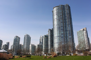
How many apartments does a city need?
I swear Vancouver must be the apartment tower capital of the world;  tall towers sprung up like weeds on both sides of the creek, false as it is. At any rate, we passed a bunch of tall buildings before ducking under the Cambie Street Bridge and coming upon a Time Top.
Maybe this is where President Obama was born

Yes, it really was a Time Top and I have no idea what a Time Top does. But there was one there, looking all the world like an alien artifact. A nearby plaque identified the contraption as a Time Top. Actually, after doing a little bit of research I found out the Time Top made its appearance in the Brick Bradford (yes, that Brick Bradford!) comic strip and the artist came from Canada. So the Time Top found a home, randomly placed, under a bridge in Vancouver.

The next item on our agenda, which was as random as the Time Top's final resting place, was the iconic Canada Place. Passing the Olympic Flame cauldron (flame extinguished when the Olympics left), we strolled on the wide promenade on the Place. Canada Place is adorned with distinctive "sails" above the businesses, hotels, and promenade walkers.  The net effect is that it feels a lot like walking a deck on the Love Boat, not that the Love Boat ever had sails on it.
Paging Captain Stubing
We had spent most of the day in Vancouver and only scratched the surface of this interesting and beautiful city. But we had a long drive to return us to the interesting and beautiful city of Winston, Oregon (sarcasm intended). On the plus side, this blog will return to the more familiar theme of hiking on trails.
Get that camera out of my face, now!


Capilano Park


Capilano Park, straddling both sides of the Capilano River canyon near Vancouver, is billed as "extreme nature" or something like that. For Dollie and I, who spend many a weekend on the various goat paths, cliffs, and mountains in southern Oregon; Capilano comes across tame and a little bit cheesy, just like fondue.   Actually fondue is quite a bit cheesy and Capilano still is a fun way to spend a frosty morning.
Dollie brings her Oregon brand of culture to Capilano Park
Dollie, on the Cliffwalk
There are three main attractions: The Cliffwalk, the Treetop Adventure, and the renown Capilano Suspension bridge dangling 230 feet above the Capilano River. As we started the Cliffwalk, a huge chunk of canyon wall broke off and tumbled into the river with a loud crack and roar, just like my dad stretching after a good night's sleep. Since the Cliffwalk is a spidery set of catwalks, seemingly frail and delicate, clinging precariously to the canyon cliffs, a landslide across the canyon was disconcerting, to say the least.

The precarious Cliffwalk


However, I am glad to report our side of the canyon stayed intact long enough for us to enjoy the Cliffwalk experience. The walk is exposed and high up there and would send any acrophobe into a panic attack similar to my wife finding a garter snake in the garden.  For us however, it compares to maybe hiking the cliffs on the Rogue River Trail, with one exception. There is a glass enclosed "diving board" jutting out into the airy void, causing me to utter a queasy "eeh" as I walked out to snap a few pictures. 


The Capilano Suspension Bridge spans the canyon and is, as mentioned, 230 feet above the river. I quickly found out there are stern-faced staff (not to mention, a stern-faced wife) posted nearby to tell certain tourists not to play on the bridge.
Capilano, himself
The Treetop Adventure


On the opposite and apparently landslide-prone side, a series of wooden catwalks and suspension bridges took us from tree to tree. Now this was cool and no one told me not to play on the bridges. It reminded me of the old computer game Myst or maybe the elf city in the Lord of the Rings. Gollum Dollie enjoyed the Treetop Adventure, also.


Hi, Mom!


The trails underneath the Treetop Adventure wound their way alongside the canyon rim in beautiful and pristine boardwalks in what was quite a change from our normal trail tread. Our feet and eyes were grateful. 


A small  creek on its way to the Capilano River


We enjoyed dangling on the various catwalks and bridges above the park but by this time we were cold (it was below freezing) so we headed back to the car, in search of warmer environs in Vancouver.


Sunday, February 26, 2012

Vancouver (Day 1)

February 26, 2012

The original plan was to ride our bikes in the Chilly Hilly ride on Bremerton Island.  That is in the Puget Sound / Seattle area for those not familiar with the Pacific Northwest. At any rate, we opted out of the Chilly Hilly for two reasons:  Chilly and Hilly.
Vancouver skyline at Coal Harbour
Dollie and I haven't ridden much lately because the weather has been so wet, cold, and miserable since what feels like 1963. It's been a long winter. So, we were unwilling to subject our pee-pee legs to the rigors of a challenging 35 mile ride. The chilly part was very obvious as we left home in a driving snowstorm. Since we were heading 500 miles north, getting up to Vancouver (our Chilly Hilly replacement destination) was most certainly in question.

Not off to a good start!


However, we need not have worried as the snowstorm in Winston was as bad as it would get, we dealt with rain and intermittent (but harmless) snow flurries on the drive up to Seattle where we overnighted with Roy (Dollie's brother).

Sun and clouds at Coal Harbour


Arriving in Vancouver the next afternoon, we immediately drove over to Stanley Park and began walking the seawall bike path next to Coal Harbour. Vancouver has to be one of the most scenic cities in the entire world. Mix in a spectacular day with clouds, sun, blue sky all competing for dominance over the cityscape, harbors (excuse me, make that harbours), marinas, bays, inlets, and some magnificent snowcapped mountains and you have one special walk and two very content walkers.
Magnificent scene at Burrard Inlet
Rounding the Stanley Park peninsula at Brockton Point with it's red-striped lighthouse, we headed towards Lion's Gate. The gate is a narrow strait on Burrard Inlet with a seemingly spindly bridge spanning the strait in what is Canada's version of the Golden Gate Bridge. Or vice versa.

Girl In A Wetsuit


Along the inlets edge was perched a small statue a la Little Mermaid, the famous Copenhagen statue. From what I read in Wikipedia, the original idea was to make a Little Mermaid replica but when permission to do so was not granted, a wetsuit and legs were slapped on the mermaid and the statue is simply called "Girl in a Wetsuit". 

Man in a wet suit


The sun was getting pretty low so we left the water's edge and headed overland via one of the many trails in the park. I got to see my first rugby pitch which looks a lot like a field from the neanderthal football played in my country.  Arriving back at the car at a tranquil Coal Harbour reflecting the cityscape nicely, we drove across the Lion's Gate Bridge and found a place to spend the night in North Vancouver.

I am a camera god


Tuesday, February 21, 2012

Lower Rogue River Trail

February 21, 2012

This was the getaway hike on the getaway day, last President's Day weekend.  Having enjoyed a superlatively sunny day and a horribly wet day on the days prior, this day split the difference as it was overcast; fortunately not a single drop of rain touched this incredibly handsome hiker.
The trail was a road walk at the start of the hike
Beginning at Agness, whose welcoming sign said "Population:  small", the first portion of the hike was on gravel roads weaving through the various Agness homesteads.  A brisk climb designed for autos and not quavering hiker legs brought me to the "real" trail but not the end of the climbing.
I should paint the bathroom this color
Topping out on a small crest wooded with oaks, the trail descended towards the very wide Rogue River, before heading back uphill.   Then it went down.  Then up.  Down.  See a trend?
Getting past this fallen tree was a challenge
As the trail approached the river, a large tree had fallen across the trail as it cut across a steep slope.  It was so not-fun to beat my way through the branches and get over the trunk via some adroit contortioning.  Whew!
 
Shortly after, the path approached a grassy pasture above the river, the large prints indicating cattle had been here not too long ago.  I'm not sure who Eddy is but a rapid in the river is named Big Eddy, the name bearing more significance to the rafting crowd.  As I walked through the pasture, the trail petered out altogether and I went back up the trail and found where I had unwittingly left the main trail for a cattle trail.


Thank you, cows!
Contouring the woods above the grassy bench, the path arrived at the first of several notable creeks:  Blue Jay Creek.  In what was false advertising, there were no blue jays that I could see or hear.  But there was a nice creek tumbling through the green and mossy forest.  A small gate took me uphill as the trail bypassed some private property alongside the river. 

Bridge at Morris Rodgers Creek
As the trail climbed, the vegetation became more Siskiyou-ish what with manzanita, evergreen coastal huckleberry, madrone, and laurel making an appearance.  After cresting at a dry and rocky slope, the trail dropped down into the Morris Rogers Creek drainage, crossing the creek on a stout bridge.  For a backwoods bridge, this trestled bridge truly was a work of art and probably is solid enough to last a millenia or two. 

After Morris Rodgers Creek, the trail began to climb in earnest and the vegetation and clime became drier as I gained elevation.  Huffing and puffing, I crested a jagged ridge and oh-my-goodness, there was a view for the ages waiting for me up there.  Even though I was all alone, I let out some jubilant war whoops at the splendor of it all.
The Rogue River, at Copper Canyon
Unbeknownst to me, while I was feeling sorry for myself climbing through viewless woods, I was at magnificent Copper Canyon.  The canyon is a narrow and rocky gorge with the turquoise and placid waters of the Rogue River pooled in between the bordering cliffs.  I was approximately 650 feet above and one step away from the river's waters.
 
A small landslide on the trail
Eeeh!


After a lengthy view-soak, I continued on the very cliffy trail.  At one point a landslide had covered the trail and I picked my way carefully across while the ground shifted under my feet with rocks rolling all the way down to the river.  Eeeh!  However, I'm glad to report no hikers were harmed in the resumption of the hike.


A brisk descent through rocky slopes and then shaded woods...well, they would have been shaded if there had been any sun; at any rate, I wound up at idyllic little Painted Rock Creek.  Since I had a long drive back to Roseburg, this was a logical turnaround point, I commenced a leisurely return hike, snapping pictures of just about everything. 
Painted Rock Creek

This was an absolutely gorgeous hike.  I'd never been on this trail before but I'll be back, preferably with a backpack on.


Monday, February 20, 2012

Cape Ferrelo

February 20, 2012

Why am I the only one out here?
OK, so the day before I hiked in the sun at Cape Sebastian and internally remonstrated with myself all the while for canning my backpack trip because bad weather was forecast.  On this day, I exited my motel room in Brookings and the rain was coming down faster than a wingless duck.  Side issue:  I've never seen a wingless duck and if it was wingless then how would it get up to the point it had to come down?  Silly metaphor, but let it be said it was raining harder than it is for a wingless duck to fly.  There I go again.
Oregon grape, getting irrigated
Whaleshead Beach, from the trail
Cape Ferrelo is on the magnificent 13 mile section of the Oregon Coast Trail in Samuel Boardman State Park, just north of Brookings.  The coast is spectacular with steep cliffs, narrow beaches, and lots of rocky island for waves to crash on.  Because of the scenery and because Highway 101 is relatively nearby, there are plenty of visitors and tourists at the many turnouts, parks, campgrounds, and viewpoints from which to access the Oregon Coast Trail.  Except when it rains faster than week-old sushi going through your system.  Another silly metaphor, and I'm not speaking from personal experience.

So, at the parking lot above Whaleshead Island, I had the whole place to myself.  Apparently the grandeur of the Oregon coastline does not hold any allure on a rainy day.  I'm not sure what the allure was for me, but the alternative was to stay cooped inside a motel room watching TV all day.  Much better to get soaked and chilled on the trail while applauding the decision not to go backpacking.
Moss and ferns, lots of moss and ferns
A newborn coral fungus

From the parking lot, the Oregon Coast trail dove into the forest where it might be presumed I'd be drier.  Nope, the only difference was that the mechanism for water transfer changed from airborne water droplets to trailside ferns.  I still got wet and some of that was self-inflicted when I lay down on the ground to take pictures of all the baby coral fungi sprouting from the mossy forest floor.

Ferns were everywhere, and anything that was not a fern was covered in a healthy layer of moss.  That's probably because it RAINS!!! in Oregon.  Creeks crossed the trail but fortunately most had footbridges over them; gotta keep the feet dry even if every other part of the body is getting drenched. 
If you like moss, this is your hike
The trail zigzagged from the bluffs overlooking a fogbound beach to paralleling busy Highway 101.  Cars whizzed by but I did catch a few incredulous "What is that guy doing out in the rain?" looks on the drivers' faces as the cars sped past. 
I just love a good wilderness hike!

After several miles, the trail egressed out onto the House Rock Viewpoint and there was not a single car in the ample parking lot.  Muttering a few apologies to my camera, I pulled it out of the dry bag and pointed towards House Rock.  An impenetrable wall of gray mist was all I could see, House Rock was closed up tighter than our cat at a visit with the veterinarian.  I'll explain the metaphor:  He does not like having his temperature taken...think about it.
"View" to House Rock
Ostensibly, the trail descends from the viewpoint to Cape Ferrelo but the cape was just a rumor in all the mist.  Slugs were my hiking companions, apparently they and deranged hikers are the only life to be found on trail in the middle of a rainstorm. 
A pictorial metaphor of me doing yard work
Leaving the forest, the trail crossed the grassy headlands above the barely visible Cape Ferrelo.  I had intended to at least get on top of the cape but strong winds changed my mind.  It's a simple math equation, really:  Take water, add 30 mile-per-hour winds and that equals one cold hiker.  I briefly entertained the idea of bypassing the cape and continuing on to Lone Ranch Beach but a trail sign advised the bridge crossing the creek had been removed for the winter.  That gave me the excuse to turn around and head back.
The shy and reclusive Cape Ferrelo

I chanted a refrain as I hiked back, something along the lines of "Why am I out here?  Why am I out here?  Why am I...?" to keep my hiking rhythm.  When I got back to Brookings, I could not drink enough hot chocolate or take a hot enough bath to warm up.   It was colder than one my ex-wife's mood swings and wetter than the time we left the hose on and departed for a three week long vacation.

Sunday, February 19, 2012

Cape Sebastian - Pistol River

My basic plan for the three day President's Day Weekend was to backpack the Lower Rogue River Trail near Gold Beach, weather permitting. Unfortunately, the weather would not permit, according to the forecast I read.  So, a three-day dayhike series was penciled in with a dry motel room reserved for each night.

View to Gold Beach and the Rogue River

Arriving at Cape Sebastian, the second-guessing began when I began my hike under clear blue skies. Dang! I should have went backpacking.  Mumbling and grumbling aside, the view from the top of the Cape north along the Oregon Coast to Gold Beach was magnificent. Leaving the views behind, the trail then tunneled into the windblown vegetation and entered a wonderfully shaded forest as it began switchbacking down towards the foot of the cape. 


Waves break below the trail
On the seaward side of the cape, the forest thinned out as the wind is really tough on trees in these parts and I got to zip off my pant legs and offer my pasty winter-white legs to the sun gods. Once at the toe of Cape Sebastian, the trail follows the shoreline south while waves break on the rocky shore below the path. 


The first ooh-and-aah moment since the start of the hike is when Hunters Cove comes into view. The entire life cycle of a wave can be observed from gentle swells entering the bay to the waves crashing upon Hunters Island, eventually petering out upon the beach shore below rocky cliffs.

Rope descent to the beach
Solid earth is a precious and transient commodity in these parts as cracks in the trail indicated the hillside is slipping downwards. Right before the beach, the trail ends abruptly at a 50-foot cliff and the final descent is made by walking backwards down the cliff while holding on to a stout rope.

Knee-deep at high tide
Once on the beach, I headed out under the spring sun with the intent of reaching the Pistol River. The numerous rock islands and sea stacks near the river beckoned. However, the tide was fairly high just after a wet ford at Myers Creek and when I found myself knee-deep in water with my back to the rock wall below Highway 101, it was "hike's over" at that point. Mildly disappointed, I turned back and made the steep climb back up the cape.


On my drive to Brookings, I noticed the tide had receded during my walk back and I thought to myself "Hmmm..." and I parked the car and it was "hike's on" at that point. The sea had receded quite a bit and all the islands were islands no more. The wet sand was firm enough for comfortable walking and I poked my camera into the nooks and crannies on the islands, taking pictures of mussels, barnacles, and starfish. 

Pistol River


The Pistol River was running deep and fast and put an end to any thoughts of continuing south along the beach. Returning the way I came, clouds came in and the afternoon sun behind the clouds kept my camera busy. All in all, a great hike even if I had to do it in two parts.


End of a great hike