Showing posts with label Gold Beach. Show all posts

Thursday, March 25, 2021

Sisters Rock


Enough was enough! I'd been sulking in hiking purgatory ever since my hernia surgery but I just had to get out onto the trail, even though the day was still technically within the doctor-ordained purgatorial time frame. But I figured a short "hike" at Sisters Rock out at the coast would get me outdoors without causing myself further injury.

"I'll keep an eye out for you!"

Sisters Rock actually is a geologic sisterhood of several large and pyramidal rocky points, and I've sped past them many a time while whizzing down the Coast Highway on my way to worthier hikes, the Sisters getting categorized as unworthy due to the shortness of the "hike". But nonetheless, the Sisters remained on my radar because they are a spectacular sight even when seen from a speeding car. 

One small rusting piece of what was once Frankport, Oregon

During the 1850’s a shipping dock was constructed at Sisters Rock and the town of Frankport sprung up to service the shipping operations. Nowadays, all that remains of the town are rusting metal parts and miscellaneous debris strewn about Frankport Beach. Around 2009, Sisters Rock was brought into the Oregon State Parks system which then did the right thing in closing the road down to the rocks, thereby converting the rickety road into a hiking trail. 

People used to drive down this road?

Well, I may have sped down the highway to get here but there'd be no speeding on the old road leading down to the rocks. The rough track was steep, rugged, and rocky enough to present a mild challenge to a recovering hernia addict on foot. I can't even imagine driving a vehicle down to the rocks, and I have a Jeep. I think you'd want to go down with a vehicle, friends, and family members you don't particularly care about! On the plus side though, the views were immediately awesome.

Just another gloomy day in paradise

On the negative side, the weather was also immediately awesome, just not in a good way. The temperature was cold, just marginally above freezing. A stiff breeze sweeping in from the south made sure to move that cold air through the threads comprising whatever woefully ineffective fabric my clothing layers were made of. When the rain came, the same breeze moved the water through those very same threads. This hike definitely was a teeth-chatterer! There's always an upside though, and the sight of the storm pummeling the Oregon coast in both directions was simply splendid in a gloomy and moody way.

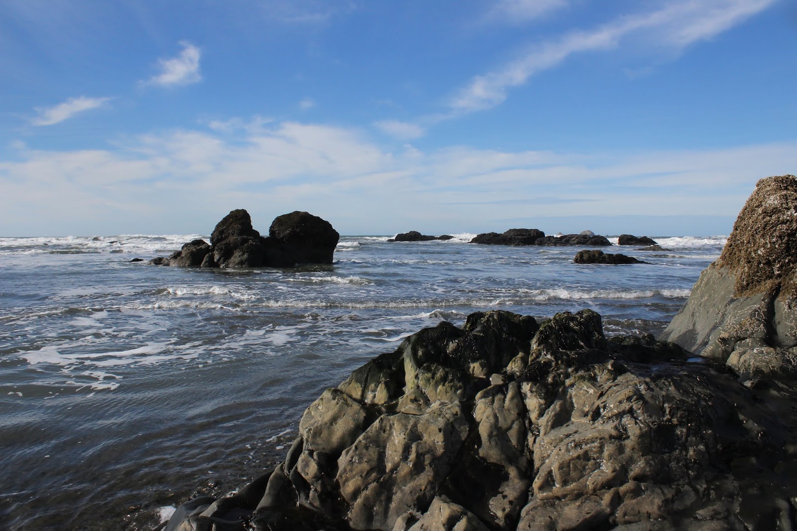
The rough-and-tumble Oregon coast to the south of Sisters Rock

Sisters Rock is actually a sorority of several sister rocks, each tenuously connected to Oregon and each other by a narrow isthmus. From the isthmus, one can explore at will and my first little foray took me to the south cove and Frankport Beach. It was high tide and the beach was off limits for those hikers wanting to stay safe, present company included. The rugged and jagged Oregon coast, dotted with rugged and jagged islands by the dozens, curved south with the rocky point of Devil's Backbone clearly visible as the shore arced away under a glum sky.

View from Frankport Beach

The beach was strewn with rusting machinery and debris in testament to the Rock's history as the former home of Frankport, Oregon. While the tide prevented further exploration south, I did tarry a bit, grateful to be sheltered from the wind by a kind and caring Sister. Lest I get too comfortable though, I had to briefly endure getting pelted by a passing squall of hail.

View across a bay to Humbug Mountain

Fortunately, the weather improved while I idled behind the leeward side of the lesser Sister and when I hiked over to the Big Sister, sun and blue sky made an appearance here and there between the still abundant clouds. Despite the sun, it was still the same cold wind though, although the sun and clouds added a whole new dramatic look to Humbug Mountain lording it over a choppy sea.

Entrance to Poseidon's realm

Sisters Rock herself is basically a large pyramid sited above a flat and rocky bench replete with tide pools, the formidable face and erstwhile symmetry of the rock being sort of marred by a large hole in it. Was that an entrance into a mine, or a portal to a forbidden underworld full of slimy coastal orcs? A short scramble up to the lip revealed the answer, it was a sea cave, full of ocean water pulsing with each tidal surge. Pretty cool, but I carefully backed away from the edge, not wanting to become a tasty and incredibly handsome morsel falling into Big Sister's slobbery maw.

View to another Sister just off shore

There is a roughhewn road leading up to a saddle between two of the rocks and that was the last little item of business on this short "hike". A solitary Sister floating offshore was neatly framed between the two rocks like a target in a geological gunsight. Waves broke on the shore below in white-watered glory and I counted four sea cave entrances at the base of Sisters Rock herself. Wow, the seemingly solid rock must be as hollow as a molar after a lifetime of eating cotton candy!

It was an "all of the above" weather day!

Normally, I wouldn't deign to drive several hours just to "hike" a couple of miles but in this case, the day was a qualified success. My recovering abdomen handled the "hike" just fine and any hike where you can say "I don't have any new hernias or reopened incisions" is a good hike! 

Tidal pools form below the Sisters

For more photos of this hike, please visit the Flickr album.

Tuesday, September 22, 2020

Humbug Mountain


I saw a meme recently that said "Sex is good, but have you ever tried fresh air after breathing wildfire smoke for a week?" That was a perfect way to describe the not so lovely experience of having your entire state go up in flames. Filled with choking and suffocating smoke, the acrid air turned us all into dedicated Air Quality Index (AQI) watchers. The AQI scale runs from 0 (best) to 500 (worst), and the very worst AQI category or rating is that of Hazardous, which requires an AQI reading of 301 or higher. Much to our horror, our AQI numbers climbed to a point completely off the scale, reaching a peak reading up into the mid-700s. The high numbers made for a macabre cause for celebration when the AQI numbers finally dipped below 300. "Yay, our air improved to Very Unhealthy!" is a so very 2020 thing to say.

Welcome to Mars, Oregon!

Now, we've experienced forest fires before but this was different. The fires not only immolated our favorite forests but also burned in towns and cities where amazingly, we could not put the flames out. The mountain towns of Blue River, Detroit, and Mill City were virtually wiped off the face of the earth. And in what to me was absolutely shocking, the Alameda Fire, driven by strong winds, roared up the urban setting of Bear Creek Valley and destroyed huge chunks of the cities of Phoenix and Talent, including the downtown areas. Unbelievable. At the time of this hike, large swaths of Forest Service lands (and trails contained within) had been declared off limits along with many state parks. Obviously, my humble little pastime of hiking went on hiatus for a couple of weeks.

A tree wants to give a Humbug hug

Fortunately, cool weather and some rain rolled in, which immensely aided the fire crews charged with tamping down the wildfires filling up the air with choking smoke. It was nice to have normal and natural gray-colored sky instead of one tinted that weird and ungodly Martian orange. Because of the aforementioned closures, the only go-to place really was somewhere out at the coast. Taking a longer drive than usual, I headed to a trail that I had only done once before: Humbug Mountain. 

Moss claims all that does not move

Lore has it that in the mid-1800s, Captain William Tichenor dispatched a scout party that went north in error instead of south. An irritated captain renamed the peak from Sugarloaf Mountain to Tichenor's Humbug to forever memorialize the directionally-challenged expedition. Over time, the name shortened to Humbug Mountain and that’s how the mountain got its name. In our present-day modern time, the mountain is now the centerpiece of Humbug Mountain State Park and a nice five-mile loop trail takes hikers up to the top of the forested peak. At a little over 1,760 feet tall, the peak is not the tallest mountain in the world but it is a 1,700 climb to get to the summit and you have just 2.5 miles to get there. In any part of the world, that is a steep trail.

Magical forest on Humbug Mountain

But while you are huffing and puffing your way up the path, you do get to immerse yourself in a gorgeous forest with some dense stands of myrtlewood trees perfuming the forest air with their fragrant leaves. Maples also populate the slopes and on the day that I went, they were beginning to blush yellow in advance of the coming fall season. At ground level, rampant greenery encroached the trail and the sweet caress of fern fronds on my legs were a constant as I hiked by.

Cape Blanco lies in the distance beyond Port Orford

I had been to the top of Humbug Mountain something like 15 years ago and decided, much like Captain Tichenor and his dispatchees, that the mountain was indeed full of humbug. At the top back then was a bench sited in a small meadow ringed by tall trees, a complete lack of view the bitter payoff for all that uphill slogging. However, sometime during the intervening years, the offending trees were cut down and now a vista of epic proportion is the appropriate reward for persevering hikers.

The reward for hiking to the top of Humbug Mountain

On the way up, a couple of breaks in the forest cover did offer tantalizing peeks at Battle Rock, Port Orford Head, and the small town of Port Orford itself. But at the summit, the view to south is unimpeded and the smooth curve of the coast arcing all the way to Otter Point is broken up only by the rocky point of Sisters Rocks. Beyond and inland of the coast, rise the formidable high peaks of the Kalmiopsis Wilderness, although the cloud cover clinging to the mountains afforded me just fleeting glimpses thereof. Several rustic benches provided the means for appreciative hikers to rest, eat, and generally just sit and meditate upon the coastal splendor absent any trace of humbug.

My legs and ferns became well acquainted 

At the trailhead, there had been a sign warning hikers that a fallen tree was blocking the East Summit Trail and don't you know that a sign like that means I had to go hike the East Summit Trail on the way down? Yes, there was a large tree blocking the trail but really, it was like a million other trees I've had to clamber over. A little tedious to scramble off the trail on the downhill side to get past but really, it was not that big of a deal. I'm glad I did return by the East Summit Trail because the huge old growth giants in the forest were amazing. Huge and majestic Douglas fir trees were collectively battle scarred, all proudly bearing singe marks from some fire of yore. Per the state park website, a fire had burned on the north side of the mountain in 1958 so maybe the fire scars on the trees are that old. So am I, for that matter, but at least I don't have burn marks on my legs.

Photographic allegory of my hiking

For more photos of this hike, please visit the Flickr album.

Tuesday, February 4, 2020

Otter Point


Way back when Oregon was being created, the Grand Terraformer put the finishing touches on the coast, looked upon her handiwork and decided something was missing. But what? "Oh, I know!" she said, brightly snapping her fingers for emphasis "There otter be a point!" And that is my theory as to how Otter Point got its name. Of course, the point could have also gotten its name because otters live there but that would be too easy.

One small piece of the beach treasure chest
Weak puns aside, it was a glorious day at the Oregon coast. The sun was out, the sky was blue, and boy howdy, was it ever cold! The sun was about as useful as a bubble gum machine in a tetanus ward, and five seconds after I removed my jacket, I hurriedly put it back on to stave off immediate hypothermia. A brisk breeze was moving all that cold air around, cutting right through the fabric of all my layers of clothing, rendering them as useful as a sprinkler system in a Fizzie factory. Ok, I'll quit.

The Queen
While I started this hike with chattering teeth, my companion had no issues at all with the chill air as she mindlessly sprinted to and fro on the beach. Luna, my canine hiking buddy of the day, has only one speed and that is a full sprint. Sadly, she's been showing her age lately and I've decided I need to start curtailing her hiking (she gets pretty gimpy the following day). When I informed her she had to stay home today, she just looked at me with those sad eyes which turned out to be way more effective than rubber lips on a woodpecker, and that's how she got invited to come along.

The jetty ends here


The hike began on the north jetty flanking the mouth of the mighty Rogue River where it empties its rather large flow into the Pacific Ocean. A short walk on the jetty delivered us to a beach comprised of rounded pebbles, the surf making a gravelly sound with each pebble-filled wave. This beach (hereafter referred to by its proper name: Bailey Beach) is a beachcomber's paradise but we had a hike to perform, so we didn't stop too much to browse for beach treasure.

Lots of islands dotted the surf
We left the luxury homes overlooking the beach behind when we rounded a small point after nearly a mile of hiking. In front of us stretched the wild Oregon coast all the way to distant Humbug Mountain. Halfway in between, a low brown bluff was Otter Point (today's hiking destination) still waiting for us from several miles away. In the surf, dozens of small rock islands, seemingly flung into the ocean during a divine temper tantrum, provided some photographic stops every now and then. The beach was remarkably free of seagulls, thanks to my four-legged bird enforcement officer.

One creek splits into thousands of braided creeklets
There were a number of small nameless creeks fanning out across the beach, their shallow rivulets as intricately braided as a reggae hairdo. None of them were running deep so only boot soles and the bottoms of paws got wet. The wet sand and trickling creeks sparkled in the noonday sun like a thousand points of light reflecting from a mirror ball in a concert hall. Much photography ensued.

The Oregon Coast Trail heads up to Otter Point
After about three miles of pleasant beach walking as the tide waned noticeably, the cliffs of Otter Point blocked further progress northward. Time to grab the Oregon Coast Trail off the beach, the short climb to the top of the point having legs burning in short order.

Hubbard Mound got its name
because...because...ah, I got nothing
We didn't tarry too long atop Otter Point, for the wind was cuffing us around pretty good. However, we did stay long enough to appreciate the view to Hubbard Mound, the next point to the north. Try as I might, I haven't yet been able to come up with a dumb story as to how Hubbard Mound got its name, but I'm still working on that.

Bailey Beach in the afternoon light
Below and to the south of Otter Point, lay glistening Bailey Beach with nary a soul to be seen on the silver sands. After a quick snack break for Luna and I on a strategically sited bench at a forested overlook, we made the short descent down to the beach and headed back in the direction of the Rogue River.


Luna is off and running


It was low tide and the beach was as wide as two time zones. All the little rock islands were just rocks now, stranded high and dry by the retreating ocean. And as the sun lowered in the sky, the sea glimmered like so many twinkling diamonds. Luna finally gave up on beach running and began walking at my speed, a rarity for her. At any rate, the hike finally came to a close at Doyle Point, which is a good thing because without the point, the end of this hike would be pointless, like the end of this blog.

Abstract art painted by sand and tide
For more pictures of this hike, please visit the Flickr album.


Saturday, June 8, 2019

Illinois River Trail (to Indigo Creek)


A quick limerick about this hike:

Men are from Mars and women are from Venus
This is a tale of a hike in extemis
If I may be so bold,
This story to be told
Of a tick, a man, and his penis!

Quintessential sunny day in the Siskiyous
Yup, and here I thought it was only deer I had to worry about! You know, it had been an enjoyable run of several years where the ticks completely left me alone while simultaneously pestering and tormenting my hiking buddies. Being the totally empathetic individual that I am, all kinds of jokes, quips, taunts, and verbal slings and arrows of outrageous fortune were directed at hikers less fortunate than my tick-immune self. Clearly it was time for karma to champion the cause of my picked-upon comrades by making me repent for every tick-magnet joke that ever found its way out of my mouth or onto my blog page.

Unsullied by the Biscuit Fire
After our challenging hike on the Oregon Coast Trail the day prior, it was made known to me that today's venture needed to be a "mountain hike". Well, fortunately for your eminent hike director, the Siskiyous were just a short drive from the coast so we headed up the Rogue River to Oak Flat, a primitive campground next to the Illinois River just upstream from where it joins up with the Rogue. This area had been burned in Oregon's largest wildfire ever, the massive Biscuit Fire of 2002. Burning just a few acres short of a half-million, the fire nearly burned all the way to Oak Flat. So, it was no real big surprise when after a short walk on the Illinois River Trail in a forest untouched by fire, and as green and shady as a forest should be, we walked out into the Biscuit burn area. 

World, meet Bridges' triteleia
The Siskiyous, unlike most other mountain ranges in Oregon, were not created by processes volcanic in origin. Nope, the rugged Siskiyous were seismically extruded from deep within the earth and are comprised of serpentinitic soils and heavy metals. Accordingly, the soils here are nutrient poor, which would explain the slow recovery from the Biscuit Fire, ably demonstrated by our hiking in terrain still denuded by the fire, even though the fire occurred eighteen years ago. Plant life must adapt to the peculiar blend of minerals in the Siskiyous and that would explain why we saw so many plant specimens common in the Siskiyous but not so much anywhere else. I was able ro recognize some of the usual suspects like California ground cone, luina, yerba santa, and elegant brodiaea. Growing all over the first part of the trail was another brodiaea type of flower, one that I had never seen before, that I was able to identify after copious research on the Internet: Bridges' triteleia (Triteleia bridgesii ). I learn something new every hike!

The bridge at Ethel Creek might, just
might, be in need of some repair
Even though we were just twenty-five or thirty miles from the coast, it can get quite hot in the comparitively arid and dry mountain range and we quickly shed jackets and sweaters as we toiled uphill in the rapidly heating-up sun. In spite of the relative aridity of the terrain, numerous creeks flowed across the path, seemingly at odds with the overall dry clime. The bridge at Ethel Creek had taken a hit from a falling tree and the fence railings were irretrievably shattered beyond repair. We were still able to walk safely across, despite the lack of safeguards.

Epic view from Mother-in-Law's Buzzard's Roost
Walking uphill should always provide a reward and this one did, the climb culminating in a superbly scenic overlook at Mother-in-Law's Buzzard's Roost. The pointed tip of the Roost would be a worthy destination in and of itself, but when the roost is poised over the deep Illinois River canyon, well it just goes to a whole other level of landscape view. The tip of the rocky spire was only about ten feet higher than the overlook and the rough terrain dropped away at our feet into a river canyon that was about one thousand feet deep. At the bottom of the canyon, the remote and inaccessible Illinois River snaked in between the surrounding mountains like the watery turquoise serpent it is. Much higher above and still mostly denuded from the fire, rose the rugged peaks of Horse Sign Butte, Lawson Butte, and Game Lake Peak. Amazingly, a trail allegedly leads from Oak Flat Campground (a low-water wade across the Illinois is required) to Game Lake, which would be like a four-thousand foot climb over eight miles or so. You'd really have to hate yourself to pull that one off and besides which, I'm not even sure if the trail exists anywhere else besides on maps.

Horse Sign Butte, in the rugged Siskiyou Mountains
At any rate, we had a much easier time of it after we crested at Mother-in-Law's Buzzard's Roost, beginning a long descent down to Indigo Creek. Here on the south-facing slopes, there was no real wildfire recovery in process. Most of the snags from the Biscuit Fire had toppled over long ago to be replaced by nothing. Well, that's not entirely accurate for the once and former forest had been supplanted by a regrettably robust growth of poison oak and buck brush. The poison oak as we all know, is more than willing and able to make hikers rue a hike through the accursed oily-leaved devil-spawned spreader of itchy torment. However, ticks thrive in malevolent abundance in the buck brush, patiently waiting for months and months to leap on the first warm blooded animal that walks by and on this day, that would be us. We quickly discerned that we were prime candidates to become tick dinner, so we stopped frequently to perform tick checks and we all plucked the odious arachnids (ticks are not insects, by the way) from our respective selves. For the remainder of the hike, this would be the hiking mode du jour because the ticks were so pervasive.

Silver Peak rules over the Illinois River and Indigo Creek
We had been hiking steadily downhill and the complete and utter lack of forest provided a great and awesomely unimpeded panorama of the surrounding landscape. Way below the trail, the Illinois had forsaken its snaky to-and-fro journey for a route that was straight as an arrow in a slot canyon for about a mile or two. At right angles to the river and between us and the Illinois was the equally impressive canyon of Indigo Creek running into the larger canyon of the Illinois. A grassy pasture at Frantz Ranch lay below the massive pyramid of Silver Peak, which someday I will hike to the top of. On our side of Indigo Creek was Fishhook Mountain, looming like a lesser version of Silver Peak. The view was magnificently epic and this is the reason we hike through tick-infested brush.

Indigo Creek, on its way to the Illinois River
The trail bottomed out at Indigo Creek, where a stout footbridge spanned the wild stream tumbling in a narrow and rocky defile. Downstream of the bridge were a series of beautiful swimming holes, if you could actually find a way down there, that is. The canyon was rough and rugged and I'm not sure you could safely get down there without mountaineering equipment and know-how. The canyon and creek scenery deserved an extended session of contemplation so we sat down in the shade of a sheer cliff and ate lunch while admiring the view.

Be glad there are no photographs of the "tick incident"
After the climb out of the Indigo Creek canyon under a hot sun and through tick-laden brush, we rounded Mother in-Law's Buzzard's Roost, and began the relatively gentle descent down to Oak Flat. It was definitely shadier and cooler on this side of the ridge we had just hiked over and around. However, an uncomfortable burning sensation "down there" was calling my attention with ever insistent urgency. During the hot slog away from Indigo Creek, I had drank enough water to feel it sloshing in my belly with each step taken. Because enough water had been drunk to stimulate the call of nature, I went behind a nearby tree with the dual purpose of relieving myself and performing a primitive backwoods medical examination. 

California ground cone was a welcome diversion from ticks
I remember being totally aghast and gasping "Noooo..." Right where a tick should never be, right next to The Anaconda's lone eye, there it was, completely embedded with disgusting little spider legs flailing in annoyance at being discovered. If I thought the pain had been uncomfortable before, that paled in comparison to the removal of the evil eight-legged invader of southern nether regions and as that little backwoods surgery took place, I could almost hear Glenn, Lane, Dollie, John, Dale, Rheo, and all the other hordes of tick victims I had ever made fun of over the years laughing in triumph as they all high-fived each other in it's-about-time celebration. We should all be thankful that in the horror of the moment, photography was completely forgotten, which was OK because I didn't bring the wide-angle camera lens anyway.

I can just sense the ticks waiting for to hike through

Because of my impromptu tickectomy procedure, I arrived at the trailhead well behind my compatriots who were blissfully unaware of my mentally scarring episode with the tick. Some of them were just putting on their shirts, sheepishly explaining they were doing tick checks in case I presumed they were having wild sex while waiting for me to arrive.  "Heh-heh", I laughed "I have a funny story about that!"

Victims of the Biscuit Fire
I've got to hand it to my people. If it would have been me listening to a hiking buddy recalling a penile encounter with a tick, I'd be rolling on the ground with laughter at my buddy's discomfiture. But not my peeps! After listening to my tale, a look of mutual horror crossed each one's face and with all the dignity that each could muster, they each dispersed behind their respective trees for a subsequent and more detailed tick check. I guess it's universal, no male likes to hear about tick bites on certain body parts, except for maybe me, I still would have laughed.

A tiger beetle is a much nicer alternative to ticks
For more pictures of this hike, please visit the Flickr album.


Sunday, May 5, 2019

Rogue River Walk

There's a pipe-dream plan percolating in my head for a future backpack trip. It begins with the Rogue River Trail, always a favorite go-to backpacking destination of mine, but once the forty mile hike ends at Foster Bar, why stop there? In my fevered imagination, I'd continue hiking about fifteen miles on the paved road to the small hamlet of Agness, and then resume trail hiking on the Lower Rogue River Trail. When that fifteen'ish mile long trail is summarily dispatched by my hiking boots, then it's like another fifteen miles on a gravel road to Boulder Bar on the Rogue River, where the Rogue River Walk begins. Finish the five or six miles of the Walk and toss in a four-mile road walk to Gold Beach, and that ends this (gotta do the math, now) close to one-hundred mile long hike from Graves Creek to Gold Beach. I probably would have to do this one by myself because my friends tend to lose interest when they hear the phrase "close to one-hundred miles", but it truly would be epic!

Alder trees reach for the sky
The Rogue River Walk is just one small piece of that ambitious would-be trek and has a unique history, having been created and built by a small army of volunteers from mostly the birding crowd. The Walk is located near the town of Gold Beach, about five miles upstream from the actual mouth of the Rogue, where  the river is wide and fairly tranquil looking when compared to the wild river found further upstream on several of the aforementioned trails. Apparently, birds hang out on the river here and the observation of the avian wildlife is the reason this trail even exists at all. Unprincipled hikers are grateful for the birds and birders creating this trail system and have no problem using the trail just for hiking on with nary a hoot about birds.

Wild iris graced the path
On the Gold Beach end of the Walk, the trail begins across the street from the former site of a large lumber mill, the concrete and pavement still visible at the mill complex, although none of the buildings or machinery remain. My plan was to hike to Boulder Bar and back, which would be about ninety miles shorter than the ambitious route discussed above. 

Red bishop's cap was spotted next to the trail
The day was warm, sunny, and cloudless.  At the trailhead, a tall blueblossom tree, a member of the ceanothus family, was in full bloom and the air was heavy and redolent with the sweet perfume emanating from the mass of blue blossoms. Branches were heavily laden with flowers and the sound of buzzing bees busy harvesting pollen serenaded me as I set foot on the trail and began hiking. The trail is pretty rough cut here but stairs aid in the quick and steep descent from the roadway down to the river. Stairs also assist on the steep climb back up to the roadway too, an event that took place after only a quarter-mile or so of hiking! What?

A horsetail provides some tie-dye art
I sure hope the birding at this spot is awesome, otherwise that made little or no sense to me. But the trail did resume again after a very short road walk to the next trailhead. I think this is what happens when birders, and not hikers, build trails and no offense intended to my feather-loving friends. The "real" trail begins at the second trailhead, in my opinion.

"Get thee gone!" she screamed
The birding aspect of this trail was readily made apparent when I walked under a tall fir with a sizable osprey nest perched atop it. It was an active nest too, and Mama Osprey was not at all happy with my presence in the vicinity thereof. Shrieking as stridently as an ex-spouse, she gave me the business and escorted me away from her tree as I did my best to quickly vacate the premises before I got dive-bombed by a furious and irate creature lethally armed with beak and talons. The rest of the hike turned out to be much more peaceful, fortunately.

Star flower played a starring and flowering role
Spring was in full song and a virtual floral tabernacle choir was delivering a full-throated anthemic paean to commemorate the season. Seemingly, every color was represented what with blue flax, red bishop's cap, yellow woodland violets, and white thimbleberry all blooming next to the trail. 

How Jim Hunt Creek got its name
Jim Hunt Creek was running pretty full so the summer route across it was not yet doable. Fortunately, an on-trail detour around the flowing stream exists and it was an easy walk to get up and around the creek flowing through the woods surrounding both creek and river. Here, the trail braids quite a bit, providing different birding loops for those so inclined. For those not so inclined, the loops still provide some great hiking through the lush vegetation and rampant greenery growing along the river.

Coyote Bar is large enough to
force the river to bend around it
Occasionally, breaks in the growth allowed for some truly awesome postcard views of the Rogue River surrounded by lesser peaks of the Coastal Range. Further upstream rose the much taller Siskiyou Mountains, from whence the Rogue River sallies forth. This time of year, the river was running wide with spring runoff and the river waters were colored a distinctive blue-green hue. Coyote Bar, a very large rocky shoal created by an 1890 flood, was eminently visible below the trail as the river curved around it. It seemed like at each and every photo stop at a river overlook or viewpoint, startled ducks flew away in quacking panic.

Ah, the sweet fragrance of a grove of laurel trees
Too bad you can't scratch 'n sniff this photo!
For me though, this hike was mostly all about the laurel trees despite the magnificent river scenery. The trail wandered through a substantial grove of them and the trees were huge. The dense canopy allowed very little sunlight to penetrate down to the forest floor and I had to kick up the ISO setting on my camera to compensate for the lack of sunlight. Where sunlight did actually manage to filter down to ground level, there were lush grassy mini-meadows and veritable shag carpets of oxalis leaves. The shade was wonderfully cool on a warm day and the fragrance of the laurels was simply intoxicating. And all this went on for a blessed mile or two!

Zen moment with ferns and trail
At the three-mile mark, the trail left the wild woods and entered civilization in the form of Huntley Park and its campgound. But not to worry, the trail resumed on the other side of the park and I was back in business on a steep trail that climbed away from the park back to the roadway above.


Tough rock-hard galls of some sort
At the high point of the hike, I sat down on a log to take a breather and noticed some black fungal type thingies growing on it. However, when I tapped on them, they were as solid, hard, and unyielding as black diamonds. What were these things? I picked up a rock and cracked one open and it was full of bug tunnels, sans bugs. Probably it was a gall but not one I'd ever seen before.

You just have to love this shady trail
Unfortunately, continuing on the trail required a road walk before the next trailhead appeared. And shortly after resuming the hike on actual trail tread, a sizable patch of downed trees blocked the way. I called it good at this debris-filled spot and turned around, happy with a 7.4 mile hike. 

A veritable shag carpet of green
I got to enjoy the stupendous river views, colorful wildflowers, and healthy exercise all over again on the way back. I also got to enjoy the deep shade underneath the laurel trees with the sweet laurel scent permeating the very air in the forest. I just wanted to sit down and stay in that forest but then I'd have to contend with Mama Osprey for that privilege.

Not much sun makes it down to the trail
For more pictures of this hike, please visit the Flickr album.