Monday, January 21, 2013

Crater Lake

Crater Lake sits in our backyard, so to speak, and happens to be one of my favorite playgrounds. However, visiting the lake in summertime is kind of a mixed bag.  The lake is outstanding but there are hordes of visitors and not all of them belong in the great outdoors. I remember seeing a paunchy man leaning way over a parapet to hand-feed a peanut to a ground squirrel, totally unaware of the sharp teeth and claws that a ground squirrel can wield or the broken bones that gravity can inflict on a roll down to the actual lake part of Crater Lake. I remember thinking "City slicker", with a heavy sigh.

The west side of Crater Lake
Another time, Dollie and I camped at the lake in early July and the lake was covered by clouds: clouds of mosquitoes, that is. The campground store was selling bottles of insect repellent at something nearing the price of gold; their supply ran out in minutes, even at the exorbitant prices. People of all countries were slapping their faces and hands while hurling multilingual invective at the invertebrate vampires.

At least they don't drink your blood
Ah, but winter is really the best time to visit the lake. Visitors are few and far between, while the lake and environs are cloaked in picturesque snow, and a profound hush envelopes the park. Pick a sunny winter day and it's a whole new level of wow factor. And best of all, there are no mosquitoes.


Snowshoe rookie


John had never been snowshoeing before and there is really only one place to go for your first showshoe trip; prescient readers will divine that the place to go is Crater Lake. Maybe the title of this blog entry gave it away. The views will astound, the trail is fairly flat, and the snow on the west side is usually firm, and snowshoeing first-timers will be suitably impressed.


Summer, in Oregon
We started the walk mid-morning at the Rim Village and the temperature was 11 degrees, a perfect temperature for snowshoers and an abomination for Floridians. The sun was out and the day would warm up to the 50's, various clothing layers were soon shed and stowed away in our packs. I would have worn shorts but my legs are whiter than the snow this deep into winter.
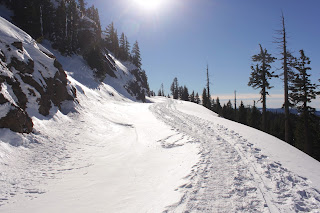


Rim Drive was our trail
The "trail" was simply Rim Drive, totally devoid of smoke belching buses and tourists, some of which are also smoke belchers. The roadway's course was always eminently visible as it carved a wide and white (just like me!) swath through the forest. And if there was ever any doubt, the path of churned up snow due to skiers and 'shoers made the trail obvious and easy to follow.

Mount Scott, across the lake
The basic pattern was to hike to a lake overlook, ooh and ahh for a bit, and then meander through forest and snowy plain, then return to the lake again. We enjoyed views of all the peaks on the lake's rim, Wizard Island, and the lake itself. Despite the relative heat wave, a thin sheet of ice covered the lake's surface.


Hello, Mount McLaughlin
To the west lay the rounded peaks of the Rogue-Umpqua Divide, to the south we could see the symmetrical cone of Mount McLaughlin and the jagged spire that is Union Peak. We could also see the tip of Mount Shasta, a mere 100 miles away. On a clear day in crystalline winter air, you can seemingly see forever.


The Watchman


We had a vain notion to climb to the summit of The Watchman but the notion seemed more daunting the closer we got to the formidable mountain. From far away, it seemed like a casual walk up a gentle slope. Up close, the "gentle" slope was more like The Great Wall of Watchman. John took a test run up a nearby hill and quickly disavowed himself of the idea of walking up a steep slope in soft snow.


Wizard Island


So back we went towards Rim Village and we got to enjoy the views all over again in the afternoon glow with lengthening shadows. John enjoyed his first snowshoe experience and stated he'd like to do another snowshoe hike. Mission accomplished, in my book.

For more pictures of this awesome place, see the Flickr album.


Saturday, January 19, 2013

Seven Devils Wayside to Bullards Beach

The Friends of the Umpqua Hiking Club had a scheduled hike from Seven Devils Wayside to Fivemile Point several weeks ago. However, it looked like it was going to be a short hike so, naturally, I began to plot a way to jazz it up. I toyed with the idea of putting on a backpack and making a weekend out of walking to Bandon and back but the weather was not all that nice and I really didn't feel like camping in the cold fog. But, hey, I can day hike in cold fog so a shuttle hike was planned for the 9'ish mile beach walk from Seven Devils to Bullards Beach, near Bandon.

If you like the color gray, then this is your hike
Joined by the usual suspects (John, Edwin, and Merle) we bid adieu to our fellow hikers who were heading north while we set off to the south in heavy fog. The weather forecast had called for a sunny day once the fog burned off but as it turned out, we would never see the sun during the hike. Too bad, because the long winter leaves me pale white like one of those blind cave salamanders that scurry away when a flashlight shines upon them.  I could really use some sun.

Fivemile Point rocks!
A short walk to the south brought us to the only obstacle we would encounter on the day: Fivemile Point. The hike leader had admonished us to be careful, citing dangerous sneaker waves from Japan. However, the sneaker waves were so sneaky we never saw them and we enjoyed a wide beach at low tide all day long. There was a greater likelihood of Beyonce not lip-synching at a presidential inauguration than there was of our being swept away by a Japanese sneaker wave.

It's a Richard Hike!
However, the tide had not finished receding when we hit Fivemile Point and we had to scramble over the mollusk encrusted rocks to get around the point. We quickly learned gray rocks were good, black rocks were bad in nature's color coding system for hiking safety. The black on the rocks was seaweed and algae and slipperier than a booger on cold concrete. Sad to say, barnacles were harmed on the crossing of the point but at least we hikers remained hale and hearty.

I don't know, Tiger, my ball just disappeared
Once around the point, miles and miles of empty beach stretched ahead of us although we couldn't see most of it due to the fog and cloud cover. Bandon Dunes, a local golf course, was on top of the shoreline cliffs and it was common for us to find golf balls in the beach debris.  


Cut Creek awaits Edwin
Edwin's going down


On the way to Bullards Beach, there were two large creeks to cross: Whisky Run and Cut Creek. Edwin leaped across Cut Creek and just as I snapped a shot of his landing he toppled over and fell with a thud. Fortunately, that was the only mishap of the day and he was bemused, muddy, but unhurt.

Bullards Beach is a rockhound's delight
About 7 miles into the walk, the sand became stony and we began to encounter other beachgoers searching for agates and other treasure in a sure sign we were nearing Bullards Beach. Edwin found a fossilized clam, I found a couple of nice chunks of petrified wood, and John found a half-dozen more golf balls.


Welcome to Chateau Bullard, accent on the "ard"
On Bullards Beach, ocean currents deposit a lot of driftwood and some enterprising soul had built what could only be described as an architectural structure for a windbreak. We paused in admiration of the engineering involved in the construction, it really was a pretty elaborate endeavor as far as beach windbreaks go.


The Coquille River Lighthouse
Not long after, the Coquille River breakwater and lighthouse came into view, signaling our hike was over. Chilled, we stopped on the way home at the Coquille Produce and Deli for some Texas burritos.  Let's just say that after two bites we were no longer chilled. We couldn't feel our tongues either and taste buds were permanently scalded into oblivion by the hottest hot sauce this side of the Pecos River. I think those burritos were more dangerous than the Japanese sneaker waves.

For more pictures of this gray hike, visit the Flickr album.

Sunday, January 13, 2013

Dellenback Dunes

It's not too often I hike a mere 3 miles and it's even less often I tell the world that I did so. Three miles is not a Richard Hike and, besides which, it's embarrassing. However, several weekends ago I had were two good reasons for hiking short: Grandchildren Aiden and Coral Rae, ages 9 and 5 respectively. Aiden had hiked with me before but this would be Coral Rae's first hike with Grandpa.

"Wow!", personified
Dellenback Dunes are, in my humble opinion, the best of the dune hikes and this hike no doubt would impress young impressionable minds. So, after several hours in the car listening to "I'm bored", "Are we there yet?", and "Can we stop and eat?", it was eminently gratifying to hear them say with all the awe in the world, "Wow!" at their first gander at  the dunes.

Death welcomed us to the dunes
It was a cold frosty morning and the temperature would never rise over the mid-30's; ice and frost rimed the leaves on all the bushes and trees when we started. The first half-mile wandered through coastal woods, lakes, and marshes before suddenly spitting us out onto the dunes. There was sand everywhere with large dunes undulating up and down with the sea on the horizon. Aiden was already off and running, which would be a recurring theme on this hike. A friend noted Aiden hikes like Maggie (the Hiking Dog) and I couldn't agree more.

Little girl on a big dune

Alas, Coral Rae's stubby little legs did not let her keep pace with her older brother, although she gamely tried. What she did do, however, was hike. The path we took required we climb atop a large dune, no easy task in soft sand, and she did so without complaint. From there, we stayed on top of what I euphemistically refer to as the "Great Dune".


Coral Rae art


It was probably unfair to plop Coral Rae in the world's biggest sandbox and ask her to walk without interruption; she periodically dropped to her knees to run sand through her fingers and make sand paintings. We were heading to a tree island and while Aiden scampered up and down and to and fro like a dog chasing scents, we walked at Coral Rae speed. Slowly and surely, we covered the miles as she prattled on about princesses and unicorns, not the usual topic of discussion I encounter on the trail.

This is how I walk downhill
We ate lunch overlooking a small pond where rainwater had collected. I had warned Aiden about quicksand and unclear on the concept, he wanted to find some and walk in it to see what it was like. To that end, he explored a grassy peninsula in the pond. The pond was well below us and Coral Rae wanted to join Aiden at the pond so she butt-scooted down the sandy dune and proceeded to play in the sand while singing songs to herself, lost in her own little girl world.

What passes for a desert in Oregon
It had been a gloriously sunny but cold day and as we ate, a small breeze began to blow with the temperature dropping noticeably so we trudged back up to the top of the dunes; well, to be clear, Coral Rae and I trudged while Aiden ran. Coral Rae found a small plant that she wanted to take to her Mommy and at every camera stop she would sink to her knees to obtain damp sand for her plant. Cute, but it was slow going.


Oregon Dunes ski resort
The north side of the dune was in shade and a layer of ice frosted the dunes. Visually, it was strange to see white where normally there would be shade. The allure of icy dunes called to the kids and they slid down the slopes sledlessly. 

Nobody else will hike with me
After a well-deserved dinner and pie in Reedsport, we headed back to Roseburg. When I returned the children to their home, they both gushed excitedly about the hike and then asked me "Can we do that again?" I think I have two new recruits!

For more pictures of this hike, please visit the Flickr album.

Saturday, January 12, 2013

Oregon Dunes

There are certain questions that a wife will ask that a husband will never answer truthfully. We all know about the iconic question "Do these pants make me look fat?" but "How much further are we going to hike?" is another one of those questions guaranteed to lead an otherwise honest husband down the Trail of Untruthful Exaggerations.

Trust me, this hike is easy
Case in point was a recent hike into the Oregon Dunes that Dollie and I did several weekends ago. She had a slightly tweaked back but bravely agreed to go hiking with me. According to the guidebook, the loop trail through the dunes was something around 5 miles.


"Whee!" in dog talk
So off we go, and after a short walk on a paved trail through the woods, we descended down into the dunes. Maggie the Hiking Dog was off and running as the recent rains had created some ponds in the random depressions in the sand. We had been on the dunes for all of two seconds and already there was a dog splashing mindlessly with sheer exuberance in a pond.

This is the proper way to hike on a wet trail
There are no trails in the dunes but the route was easy to follow from marker post to marker post. Besides which, there were lots of footprints forming an ad hoc trail to lead us in the right direction. The last post in the dunes marked the beginning of the forest section of the hike and the first little introduction to marital discord.


I am so in trouble
The sandy path through the forest happened to be under a foot or two of water. Dollie did not appreciate the watery goodness unlike Maggie who thought all the water was more fun than a bag of cats. We spent some time stepping on logs and bushes in a vain attempt to keep feet dry for the Dainty One.  


Could be worse, it could rain
Eventually, we worked our way out of the marshy forest and hit the beach. It was a grey day with a high tide, both earning two more demerits for me. We headed south on the beach and although it was high tide we had plenty of beach to hike on. There were not a lot of logs on the beach but there was plenty of tsunami debris in the form of water bottles and large plastic floats.


(Not) "Almost there!"

After a mile and a half, a sign post atop the grassy beach foredune marked the beach egress and the loop trail back through the dunes. I was feeling good and really wanted to walk further, so the walk down the beach to Tahkenitch Creek and back was suggested. In response to Dollie's query about how much further, I glibly answered something along the lines of "...not far, we are almost there as we speak!"


Soldiering bravely on
To be honest, I didn't deliberately intend to misconstrue the mileage. The guidebook indicated that the mouth of Tahkenitch Creek was a mere mile or so down the beach. The reality, however, is that Tahkenitch Creek had migrated further south, demonstrating a large creek can go wherever it wants to. And a migrating creek meant over 2 more miles of beach walking before reaching the creek's mouth. And math majors such as myself, will note the round trip to the creek it added another 4 miles to our hike.

Oyster shells
Still, there were lots of cool stuff to see as we plodded along in the soft beach sand. The smaller floats entertained Maggie who kicked them along like a soccer ball. Atop a dune, we found an old oyster bed that had been uncovered by high surf. And the overcast sky was wonderfully moody and dramatic, just like a 15 year old daughter who has just been told she can't go with her friends to the movies. Dead jellyfish decayed on the beach, emitting noxious gas bubbles just like my brother does after spaghetti dinner.

Tahkenitch Creek, in sight
As we walked, the clouds gradually turned to blue skies to the north of us. And just as we finally arrived at Tahkenitch Creek, the sun broke out and the creek glinted silver in the sun. We enjoyed a nice little lollygag along the creek as we ate lunch there while the sun restored good humor to tired hikers.


It's a Richard Hike!
After lunch, it was a 2.5 mile walk back to the trail marker and we left the beach on a sandy track. Back in the dunes proper now, the sand was soft as an unused pillow. Shortly after an overlook of Tahkenitch Creek, we hit the sands and were unable to find a trail post marker. Despite there being no trail per se, we somehow had managed to make a wrong turn.


Pain and beauty, but mostly beauty
Our route had taken us into the marshes and ponds and we spent some time working our way through all that before getting onto the more open sands with the magic markers, so to speak.  The last few miles were spent trudging painfully through some of the most beautiful dune scenery around. Pain and beauty, nothing quite sums up a hike like those two words.


Bye, Oregon Dunes
Our hike wound up being 8.6 miles that felt like a lot longer than that, but walking in soft sand will do that. I don't think Dollie will ever ask me again how much further the hike will be, though. 


For more pictures of this hike, please visit the Flicker album.


Tuesday, January 1, 2013

North Bank Deer Habitat

Statistics, statistics, I love statistics; here are mine for 2012:

I hiked 52 days in 3 states and 2 countries, averaged 7.2 miles per hike, and hiked a total of 373.5 miles. My shortest hike was 2 miles to Castle Rock and my longest was a 13.6 miler up to Mount Kit Carson (near Spokane, Washington) which also involved my scariest bear encounter ever.

Happy New Year!
So, moving on to 2013, the Friends of the Umpqua Hiking Club hiked in the  North Bank Deer Habitat in what is fast becoming our traditional New Year's Day event. Just as in years past, the hike began in bitterly cold fog, the kind of cold that slaps your cheeks like an outraged diva throwing a tantrum.


Soggy feet but no soggy bottoms at Soggy Bottoms


Starting on the Soggy Bottom Road, the trail lived up to its name as some of us splashed our way through a soggy bottom while others waded through frosty grasses striving vainly to keep boots dry. Those of us in front briefly saw the distinctive white rump (stop with the jokes, already) of a Columbia white-tailed deer, the reason for the Habitat's existence. A left turn onto the North Gate Trail took us off Soggy Bottom and then the "fun" began.


Human suffering and glory on the trail

It is difficult to avoid hiking uphill when hiking in the Habitat and one of the steepest trails is the accursed North Gate Trail which so happened to be our route. The North Gate is cruel as the trail taunts hikers by forecasting the pain and misery yet to come as the route ahead is demoralizingly visible in all its burning leg pain glory. And just when you think it can't get any steeper, it does. I don't think the deer even hike up the North Gate.

This is why we hike!
Blessings do get bestowed on hikers staggering up the North Gate in the form of magnificent views of the North Umpqua River valley. It was foggy in the valley but we were above all that so what we got to see were fingers of cloud cover with muntain tops poking through, all wonderfully illuminated by the winter sun.

All hail Year 2013!


An unfortunate byproduct of my injured wrist is that I haven't been able to play racquetball for the last 4 months and an unfortunate byproduct of not playing racquetball is getting out of shape. So when we got to the Middle Ridge, most hikers in the group headed downhill while a few hardier members opted for the uphill and longer route to the North Boundary Ridge. I waited for my trembling legs to quit trembling but they didn't so, uncharacteristically, I opted for the shorter downhill hike. I felt so unworthy.


On a clear day, you can see forever


The ignominy of passing up a Richard Hike opportunity was short lived as the views while we descended Middle Ridge were too sumptuous not to enjoy. The air was crisp and clean, a clear blue sky floated above, and we were hiking on windswept grassy hills above cloud cover. The winter air was crystal clear and we speculated what distant and large peak we could see on the horizon. I thought it was Mount McLaughlin but after consulting Google Earth, I now have to conclude that we were looking at Prescott Peak in California's Siskiyou Wilderness, a mere 100 miles away.

Return to the mist
As we lost elevation, we got closer and closer to the cloud cover, eventually entering the clouds, or fog as we like to call it. But, the fog was burning off, providing for a nice view of the North Umpqua River as we arrived at the trailhead. It was a nice way to start the new year, although we'll have to do something about that out-of-shape thing.  


For the rest of the pictures, please visit the North Bank album in Flickr.


The route