Let's raise our hiking poles in revererntial homage to the memory of
Old Reelfoot, a notoriously crafty grizzly bear that terrorized cattle and stockmen in southern Oregon in the mid-1800s. Because of a paw injured by a bear trap, his unique footprint distinguished him from all the other grizzlies hanging around the Siskiyou Mountains and because he managed to elude hunters for so long, he became somewhat of a local legend. His range was mostly in the Pilot Rock area although he made many a hunting foray down into California, making him a wanted bear in two states. He had a good run but in 1890, time ran out for the elusive bear and he was finally hunted down and killed. Posthumously,
he enjoyed a brief career as a stuffed and mounted touring exhibit in various museums, expositions, and fairs in the nation, although maybe "enjoyed" might be the wrong word here.
 |
Every time skyrocket blooms, a retina dies
|
Anyway, in Old Reelfoot's honor, a smallish mountain near Ashland was given the name Grizzly Peak which coincidentally enough is the subject matter of today's blog missive. Grizzly Peak is a short hike, totally incommensurate with Old Reelfoot's fame as a terror of the Siskiyous but on the other hand, I'd hate to run into a grizzly on the trail, no matter the mileage of the hike involved. Deer are scary enough, never mind the bears.
 |
It's a jungle out there!
|
Because it's a long drive for a short hike from Roseburg, I don't do this hike very often. In fact, this was only the second time I'd ever been to Grizzly Peak. Medford buddies Glen and Carol exposed me to this spectacular hike several years ago and while I was impressed then, I think I was even more appreciative of the rugged beauty this time out as the vegetation was a lot more lush than on my first visit, and that's the difference between hiking on Grizzly Peak in early summer instead of late spring.
 |
| But where are the poison oak and ticks? |
The trail wasted no time heading uphill at a moderately brisk rate and the first thing I noticed was the lushness of the forest undergrowth. It was a veritable jungle underneath the tall trees what with all manner of plant specie, from tall delphinium to lowly wild ginger, flourishing in riotous exuberance. Orange columbine nodded next to the trail, their dangling tassels reminding me of a graduate's mortarboard. There were so many flowers, like thimbleberry and larkspur, just to namedrop a couple. All this and I hadn't even reached the meadows yet, where the real flower show would take place. Needless to say, my pace was relaxed and slow as I enjoyed the shady trail and wildflower display.
 |
| Alien-looking cow parsnip bud |
This trail sees a lot of use because of its proximity to Ashland and Medford, and because of its relatively short length. Accordingly, the trail was wide and well kept, almost like a park path. For someone like myself accustomed to scrambling over fallen trees and wading through poison oak bushes, the civilized nature of the trail was most refreshing.
 |
The ever present Columbia windflower
|
The actual summit of Grizzly Peak is rather underwhelming, to say the least, looking like a rocky cairn in a sparse meadow surrounded by tall trees. No view, no epic barehanded scramble to the top, no sir. But then again, this hike is all about the meadows, at least immediately after the summit. The pattern for the next mile or so was to walk through alternating low-growing grassy meadows and lushly shaded forest carpeted with thick patches of candy flower.
 |
| An ornate checkered beetle on a fleabane |
In the meadows, much photography ensued, for the meadow were chock full of salsify (among many other flowering species), a yellowish sunflowerish bloom attracting a multitude of bees and butterflies. Not to be outdone were salmon polemenium (a salmon-colored Jacob's ladder), mountain-owl clover, sulphur flower, and patches of skyrocket, the brightest colored flower ever. As the trail looped around the broad and flat summit of Grizzly Peak, views of the surrounding terrain awed as they appeared through breaks in the forest cover in a taste of things to come. Although clouds took away the view of nearby Mount McLaughlin and the distant Three Sisters, I spotted Mount Thielsen, Union Peak, and the collective peaks adorning Crater Lake's rim to the northeast of Grizzly Peak.
 |
| The trail went through a series of meadows |
In 2002, a wildfire started by a sparking power line raged on the west side of Grizzly Peak and nobody really cared, because Oregon's collective attention at the time was focused on the massive Biscuit Fire. The fire here on Grizzly Peak must have burned fairly hot because during the subsequent decades, a forest has yet to return to the western slopes. However, Grizzly's arboreal loss is our hiking gain, for the views here are simply astounding.
 |
That little pimple is Roxy Ann Peak,
overlooking the city of Medford |
The hike's flavor transitioned from parklike stroll through the meadows to rugged goat track on the edge of a rocky ridge. Below the rough trail was a lesser mountain which was basically an extension of a west-side ridge of Grizzly Peak. This "little" high point dominated the near view, its rocky ridge and acres of ghostly white snags commanding our attention and respect. The ridge continued north in a series of subsequent high points, culminating in the cone of Roxy Ann Peak, looking puny from here. As an aside, Roxy Ann Peak does not look so puny when hiking up to its summit.
 |
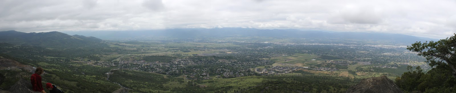
| Quite the view of Bear Creek Valley |
Beyond Roxy Ann Peak was the wide Rogue Valley with Upper and Lower Table Rocks eminently visible at the edge of the valley. Immediately to the west was deep Bear Creek Valley with the towns of Ashland, Talent, and Phoenix all safely ensconced within. The Lord of all Mountains to the South, a.k.a. Mount Shasta, rose up like the awesome snow-covered volcano it is, while local landmarks Emigrant Lake and Pilot Rock were dwarfed by the giant cone rising over all.
 |
| A bee gets a pollen bath |
This was and is my favorite part of the hike. The topography is rugged, the views astound, and on a late June day, the flowers and insects put on a show in the low meadows thriving in the old burn zone. Balsamroot, golden yarrow, common yarrow, and bright red paintbrush were all in full spring song and the winged set of insects such as bees, wasps, hoverflies, butterflies, and moths all flitted and buzzed from flower to flower. Longhorn flower beetles and other horny beetle species waded in the pollen as they fed and frolicked in and on the numerous blooms, and not necessarily in that order. On bare ground baked hard by the sun, dwarf onions waved pink and purple flower pom-poms at the blue sky overhead.
 |
Dwarf onion thrived in the hard, dry soils
|
The trail crested at a craggy overlook atop the high point of this trail and was a perfect place to eat lunch, sit, admire the view, and generally just ponder the meaning of life or go to whatever happy place your thoughts may take you to. After a totally enjoyable lunch 'n laze, I gathered up my stuff and continued hiking. The path returned to the familiar pattern of meadow to forest to meadow before closing the loop and bringing this short, but totally epic hike to an end.
 |
| A salsify captures a hoverfly's attention |
Looking at the map of this hike, I noticed that to the north, Antelope Creek does a flow-by of Grizzly Peak. That would be appropriate because what's in my head (which is not always accurate) is that the 2002 fire was called the Antelope, or maybe the West Antelope Fire. However, my copious Internet research performed for this blog post failed to confirm my suppositions one way or another. Also, I searched for anecdotes about Old Prong Horn, the feared antelope scourge of the early pioneers of the Rogue Valley and yes, I'm making that up. Since antelopes live in the southern Oregon desert on the east side of the Cascades, naturally there would be no lore about fierce antelope living on Grizzly Peak, although they could have given Old Reelfoot a literal run for his money.