Showing posts with label greensprings summit. Show all posts

Friday, May 18, 2018

Boccard Point

Just had to go get me some Cascade-Siskiyou National Monument! I love this place and really, spring is the time to go as the dry summer climate can brown out hills and meadows fairly early in the year. Ah, but in spring, meadows are green and lush, the shady forest is burgeoning with spring growth, and erstwhile arid barrens sport colorful rock gardens. Regrettably, this beautiful jewel in the National Monument system is currently on the chopping block, thanks to a misguided president who does not hike. It really would be a shame to ruin this wilderness with logging, grazing, and motorcycles.

Dangling gooseberry


Brad is slated to lead a Friends of the Umpqua hike here in June and he didn't know Boccard Point from a bagel. Naturally, that would bring into question his leadership abilities: knowing where you are going does tend to automatically impart an air of confidence and competence. Richard to the rescue, though! I was enlisted to show him the way ahead of the official hike, and I only too gladly obliged, seeing how this wilderness is one of my favorite hiking haunts.

Dwarf hesperochiron ruled dry soils
We couldn't have picked a better day. It had rained the evening before but we began hiking under a gloriously blue sky. Despite the ample sun, the temperatures were fairly mild and the forest had that whole post-rain moistness thing going on. Leaving the Hobart Bluff Trailhead, the Pacific Crest Trail (PCT) ambled under some power lines right at the start and entered an arid field. Despite the dryness in the open and rocky soil, phlox, larkspur, and thousands of dwarf hesperochirons were coloring up the rocky barren. We hadn't walked even a quarter-mile and already, I was crawling on my hands and knees, photographically cataloging every wildflower specie thriving in the small barren. Welcome to "Hiking with Richard", Brad!

Trillium dominated the shady forest


One of the things I particularly enjoy about this stretch of the PCT is that the scenery alternates stark hardscrabble with verdant forests and meadows. It's like a patchwork quilt of contrary macro-ecologies. So, after the hands-and-knees photo-shoot of low-growing wildflowers, we followed the PCT into a wonderfully shaded forest with elegant and stately trillium blooming in profuse rampantness (Rampitude? Rampantenacity? Rampantage?). 

Meadow...'nuff said!
Once past the intersection with the Soda Mountain Trail, the PCT leapfrogged from meadow to meadow, all colored bright green under an equally bright blue sky. There is just something about blue and green that is inherently pleasing to the eye. We were hiking on the Cascade-Siskiyou crest and and enjoyed constant and great views down Bear Creek Valley, Ashland, Medford, and the Siskiyou Mountains near Mount Ashland. 

The venerable Pacific Crest Trail
The trail had been remarkably level for the first several miles but then it plunged for a mile or so, losing elevation at an alarming rate, considering we would have to gain it all back on the return leg. The mile-long descent ended at a jeep-road/trailhead combo and that was our cue to leave the PCT and follow the faint path to Boccard Point.

Sketchy path near Boccard Point
Before losing all that elevation, we had a pretty close sideswipe view of Boccard Point but the PCT had continued on past the point for the aforementioned mile of downhill walking. Now, the Boccard Point Trail doubled back below the PCT and gained all the lost elevation and distance back, with the same deleterious effects on the way out. Trail designers are sadistic demons, there is no other way to explain the route.

Trail, barely visible atop Boccard Point
While faint and sketchy, the path followed an old roadbed so the route was easy to follow as it angled gently and steadily for the two miles leading up to Boccard Point. The day had warmed up considerably from our cool start, and we were feeling the sun on the open roadbed. Finally, the trail leveled out in shady forest atop Boccard Point and we ate lunch on a small promontory.

You can see California from here!
Lunch always tastes better when spiced up with a view, and this lunch was delicious. To the west, Pilot Rock was the nearest neighboring peak, it's silhouette backdropped by the slightly snow-covered Siskiyou Mountains. But it was the view to the south commanding our rapt attention. The Cascade-Siskiyou mountain range dropped at our feet and Irongate Reservoir glistened in the afternoon sunlight. Mount Shasta, its snowy tip hidden by clouds, rose up on the opposite of the Shasta Valley.  Bowing down at Mount Shasta's feet like a devoted disciple, Black Butte displayed the reverence that is only proper when in the presence of greatness. To the west of Shasta was Mount Eddy and the rest of his Scott Mountain friends. It was amazing to consider the very same PCT we had hiked on today, also traverses Mount Eddy in the far distance

Brad-fu
The view was epic and eminently enjoyable and besides which, us Oregonians derive a certain smug satisfaction from looking down our noses on California, both literally and metaphorically. The magnificent scenery just compelled us to act like the idiots we are, so I broke out my "Running Man" pose while Brad busted some sword-fu fighter move which he called "The Brad".

The tip of Mount McLaughlin, from the PCT


All that re-gaining of lost elevation was not fun and I was pooped by the time the PCT crested a mile or so west of Soda Mountain. But fortunately, the trail was level from there on in. The act of taking a photograph is the last refuge of a tired hiker, and more pictures were amassed as this 10 mile hike came to a close. Despite the fatigue, I still remain madly, deeply, and truly in love with the Cascade-Siskiyou National Monument.

Hazy view down Bear Creek Valley
For more pictures of this hike, please visit the Flickr album.


Monday, June 20, 2016

Hobart Bluff

Recently, I went on yet another hike in the Cascade-Siskiyou National Monument. Am I overdoing it? Will I become jaded about hiking in the Monument? Will the Monument eventually fill me with ennui? Is it possible to get too much of a good thing? I think not in this case, the scenery and greenery are just too beautiful.


Why we hike
The object of my hiking affection this time was Hobart Bluff, selected in part because of an earlier hike from Greensprings Summit to Little Hyatt Lake on the Pacific Crest Trail. I remember my comrades asking me what was south of Greensprings Summit and the short answer is Hobart Bluff. The long answer is the border with Mexico. Anyway, this area dries up and goes brown fairly early so I figured I'd better go to the monument one more time while everything is still beautifully green.

This hike sponsored by Pale Ale
The weather was great as the sun was out, the sky was gloriously blue and best of all, the temperature was mild and perfect for hiking. From the trailhead, the venerable Pacific Crest Trail climbed gently in a fenced corridor on private property. Once past a couple of gates, the trail would be on public land the rest of the way and thanks to the property owners for allowing the trail to pass through their land.

Dry meadow on the PCT
The trail ambled through an odd mix of lush Cascadian conifer forest and open Siskiyou-ish meadows and oak savannas. It can also be an odd mix of mosquitoes and ticks, based on the same vegetative mix but on this day I was lucky enough to not have to deal with either pest. This area is fairly arid when compared to the moister Cascades, here the meadows were already going brown in the rockier stretches of trail. One good thing about meadows is there are no trees to block the view and periodically I caught glimpses of Pilot Rock and Mount Ashland.

Blue-headed gilia
Spring was in session, and my hiking pace was relaxed as there were so many wildflowers to take pictures of. Purple balls of ookow were the main culprit but white hyacinth, thimbleberry, columbine, Indian paintbrush, and larkspur all made their floral presence known. I was happily taking photos and just go ahead and call me a flower child.

Phantom orchid
After several miles of drying meadows alternating with oak or conifer forest, the trail climbed up a slope that was comprised mostly of old-growth Douglas fir. The trail was well shaded with lush vegetation greening up the forest floor underneath the massive trees. Phantom orchid is a fairly rare plant but here it was sprouting everywhere. Pick a square dekameter of forest floor at random and hundreds of pale white shoots would still issue out of the ground like ghostly wraiths from the underworld. The orchids were a pleasant distraction from one of the few steep stretches of trail.


A hike with a view
Shortly after leaving the orchid-infested slope behind, the trail crossed over to the east side of the ridge crest and the forest transitioned to scrubby chaparral and thin stands of scrawny oaks. The views from the open slopes transformed this hike from "pretty darn cool" to "Dude!" (in the like, totally awesome sense of the word). Miles and miles of hills and volcanic cones carpeted by forest lay underneath a blue sky. Nearby Parker Mountain was the most prominent peak as the landscape rolled towards Klamath Falls, but fortunately the town was not visible. I know that may have been an underserved Klamath Falls cheap shot, but then again, I've been there!

A bee-fly sips from a larkspur
Periodically, oaks arched over the trail and the mottled shade was most welcome and soothing. Swallowtail butterflies flitted from flower to flower and my camera was quite busy with shady trail, abundant wildflowers, insect life, and expansive views.

This way to Hobart Bluff
So far, the route had not been all that strenuous as it rambled along the ridge crest in relatively gentle ups and downs. Hobart Bluff would require some more exertion however, as the trail to the summit charged madly up the bluff, about as subtle as an enraged bull on the other side of the fence from the cow. Stunted and gnarled juniper trees dotted the grassy slopes of the bluff.

Hobart Lake, from the world's tallest diving board

Hobart Mountain (near) and Pilot Rock (far)
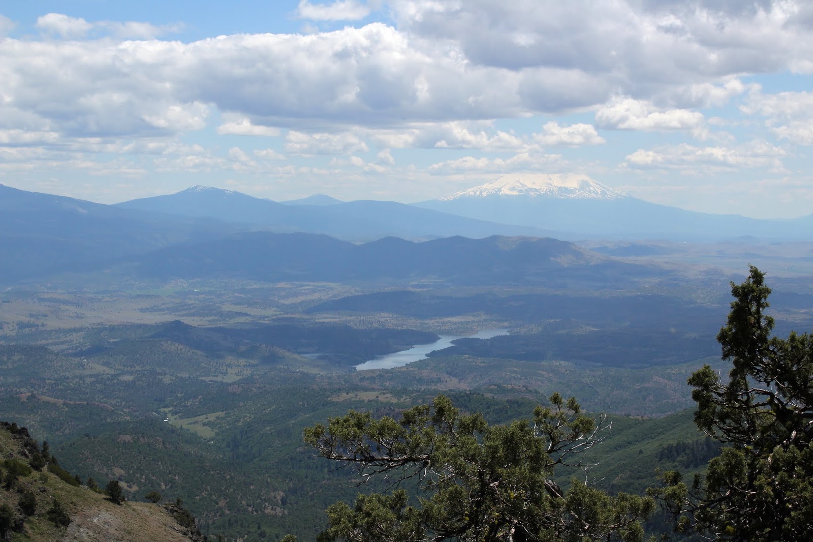
After attaining the actual Hobart Bluff summit, I picked my way down to a rocky point which was the definitive edge of the bluff, one more step and I'd painfully splash into Hobart Lake, about 450 feet below. The 360 degree view from Hobart Bluff was predictably spectacular, especially on such a glorious day. Hobart Mountain is Hobart Bluff's immediate neighbor, its green slopes rising in front of equally green Soda Mountain. In the distance was the squat tower of Pilot Rock, looking somewhat alien in all the forested mountains. Farther away were Mount McLaughlin, Mount Ashland, and the tip of Mount Shasta. However, Bear Creek Valley stole the Hobart Bluff show. Wide and deep, flanked by tall mountains, the valley stretched from Ashland to Medford and I was staring right down the valley's throat like a geologic tonsillologist. Way cool and lunch just tastes better when eaten in the presence of such an awesome vista.

Meadow, set aside as habitat for
the endangered Mardon skipper
All good things come to an end though, so after a lazy lunch, it was time to get off the butte and head back down the trail. I had entertained a notion of summiting Hobart Mountain's green and grassy slopes so I continued on the Pacific Crest Trail to the foot of the nearby mountain. Upon closer inspection, the green grass was actually a dense head-high thicket of brush and small trees. Wanting to keep my skin reasonably unscratched, I instead continued on to the Soda Mountain Trailhead for some extra mileage. The trailhead was the logical turnaround point, but not before availing myself of the brand new outhouse. Actually, I think if I bushwhack around (next time) the north side of Hobart Mountain, I should be able to make it to the summit.

"Get that camera out of here!"
The afternoon cooled off a bit as the sun sank low or maybe it was just my appreciation for shady forests, but it was a pleasant hike back to the car. So, in answer to my question first posed in this blog entry, one more hike in the Cascade-Siskiyou National Monument is not too much of a good thing. However, other trails in other places are also calling to me and I'll save the few remaining monument trails for a later date.

The PCT alternated between sun and shade
For more pictures of this hike, please visit the Flickr album.

Grassy stretch of trail

Friday, June 10, 2016

Boccard Point


Did I really say I hated hiking? Me? In my last blog entry? Really? No way! Such a thing is simply not possible, I love hiking, it's the best! Now admittedly, on my last hike on Grasshopper Mountain, I did let several thousand fallen trees sour my attitude just a smidge. But hikes like the one to Boccard Point are so sublime, so beautiful, so enjoyable that faith in my little hobby cannot help but be restored, even following such an epically so un-fun hike.

Chickweed blooms amok next to the PCT
The Cascade-Siskiyou National Monument was created in 2000 and sort of languished in benign neglect for the next decade or so. However, in 2009 the Soda Mountain Wilderness (within the monument) was established and the monument has seen the love since, with obvious signs thereof readily apparent to regular visitors to the Soda Mountain area. All the jeep roads have either been closed or converted to hiking trails, new signs keep hikers apprised of location, and the Soda Mountain Trailhead now sports a gravel parking lot (it used to be you just parked on the side of the road) with a brand new outhouse. The Pacific Crest Trail has been rerouted around some meadows which are now designated and protected as habitat for the endangered Mardon skipper. And, as it turned out, the monument was just the perfect place to rinse out that nasty fallen tree taste left over from my last hike.

Onion spices up the hike


Heading west on the Pacific Crest Trail up a rocky slope underneath some power lines, it was immediately evident that spring was in full song. Although bare and rocky, the slope was carpeted with fuzzy pink balls of onion flowers. Bright red Indian paintbrush, pastel yellow cinquefoil, and deep blue larkspur added to the floral rainbow on either side of the trail. In some of that Monument love I had talked about, the PCT had been neatly stair-stepped with rocks in a few places.


Star-flowered Solomon's seal
After crossing the rocky slope, the trail then in short order passed through a lush conifer forest that had a veritable jungle growing underneath, followed by an open stony area with no trees. And that perfectly sums up the Cascade-Siskiyou Monument hiking experience in that one hikes in a patchwork quilt of vegetational biomes from dense conifer forest to rocky barrens, and from lush hellebore meadows to drier oak woods. At any rate, the forest was carpeted with Jacob's ladder, false Solomon's seal, and star-flowered Solomon's seal. After the intersection with the Soda Mountain Trail, it would be all new trail for me from here on in. And best of all, I only had to step over only about two trees the entire day, what a difference from my last hike!

Dubious water stop on the PCT
The weather was overcast, cool, and windy, but the cloud cover was fairly high. The trail entered a series of large meadows of ankle high hellebore and the resultant openings in the forest provided impressive views of Mount Ashland, Bear Creek Valley, and Grizzly Peak. A side trail led to a stagnant livestock pond that is the only water source within many a mile for PCT thru-hikers, obviously the pond gets a lot of use despite the relative poor water quality.


Shadow on a shady trail
I had been walking on the north side of the crest and at a forested saddle, the route crossed over to the south side where the clime was a little bit drier, judging by the rather sudden transition from conifer to oak forest. At the saddle, Boccard Point first came into view although the trail continued away from the point for several miles before doubling back on an old road bed. Over the next few miles, the clouds dissipated as the trail descended to a mildly confusing intersection of dirt roads southwest of  Little Pilot Peak. Fortunately, there were trail signs to keep me on track.

The trail to Boccard Point
The trail from the PCT to Boccard Point followed an old road bed abandoned long ago. Nowadays, the old road is a narrow path angling gently uphill through tall grass and around boulders that have rolled down from the former road cut. By now, the sky was a glorious blue color, the trail was flanked by dark green trees, and I had a clear view of Boccard Point still demoralizingly high above. Crap, two out of three isn't bad but really, the grade was fairly gentle as it angled across the slope of Boccard Point.

You can see California from here!
After a short walk atop a thickly forested bench on a trail that was hard to follow in the undergrowth, I ate lunch on a rocky mound that I assumed to be the point of Boccard Point. However, I could see another similar mound nearby with one big rocky thing further along the cliff I was perched on. A post-hike check of the map showed that the true Boccard Point summit had actually been hiding in the forest behind me.

View towards Pilot Rock
But quibbling aside over which point was the true point, what a view! The entire Shasta Valley in California was laid out below with Iron Gate Reservoir sparking blue in the brown terrain like a sapphire jewel in a puddle of gravy. Whew, that metaphor makes no sense but let's move on. Pilot Rock was silhouetted nearby with Mount Ashland just beyond. Despite the haze and clouds hiding Mount Shasta from sight, the view was still pretty stupendous. Plus, we Oregonians really enjoy looking down our noses at California. Such a view requires some lazy tarrying but a cold wind was cutting right through my clothing, so a hasty retreat was beat off the point.

Blazing star
On the way back as the afternoon sun slanted through the trees, the cold wind was a constant. Summer has not yet arrived, at least not anywhere near Soda Mountain. I never saw another hiker all day and it was a pleasantly lonely hike back to the car. There were plenty of new bear scratchings on the trail that had not been there on the incoming leg. Fortunately, there were no bear encounters to report...this time. The day remained visually sunny but physically cold while clouds formed and reformed over the monument. The meadows, flowers, and views were enjoyed all over again, recharging both soul and spirit. Hikes like this are why we hike and I love hiking! Really!

A crab spider lurks
For more pictures of this hike, please visit the Flickr album.


Saturday, May 21, 2016

Little Hyatt Lake

This Friends of the Umpqua hike was sparsely attended, probably because of the cold rain and/or baking hot sun in the forecast. Or more likely, the sparse attendance was due to the fact it was led by yours truly. Whatever the reason for staying at home, the weather was simply schizophrenic, changing every 10 minutes or so. I tried to keep up, putting on and taking off rain gear with the changing climes but eventually I gave up and just left the rain gear on, guaranteeing I'd be sensibly attired at least half the time.

Henderson's fawn lily
Leaving Greensprings Summit on Highway 66, the Pacific Crest Trail ambled through intermittent meadows and forest. Regardless of the terrain, the vegetation was always lush and green. Spring was in full song and wildflowers soon kept my camera busy and me lagging at the tail end of the hiking queue, but what else is new? The meadows were soggy, making the PCT a muddy and gooey mess in places. The general consensus of PCT thru-hikers is that this particular stretch of the venerable trail is boring and uninteresting but I beg to differ. I do love my meadows and am definitely a fan of the Cascade-Siskiyou National Monument. 

What's a hike without an obstacle or two?
After crossing gravel Hyatt Lake Road for the second time, the trail perambulated around Greensprings Summit. In several places, a few chunks of snow were still hanging around from winter but we didn't need to break out the snowshoes and crampons just yet. Once the PCT got onto the western slopes of Greensprings Mountain, the really cool stuff started to happen. The slopes were bald and green, just like me, and provided limited but still pretty awesome views of Bear Creek Valley. 

View to Bear Creek Valley
Bear Creek Valley contains the towns of Ashland, Phoenix, and Talent with the I-5 freeway linking them all together. Sounds pretty urban but the valley is mostly rural and surrounded by mountains. On this day, the mountains were all hidden by clouds but the valley was enjoying a sunny morning as were we, and the views of the valley stretching north to Medford were impressive.

Hyatt Meadows blushes with sea blush


After enjoying just under a mile of meadows and views, the PCT ducked back into the forest and once again we crossed Hyatt Lake Road. The next item on our PCT sampler was Hyatt Meadows which is actually one incredibly large meadow. I think the entire principality of San Marino could fit in Hyatt Meadows, it's so big. The sun cooperated with us as we crossed and the meadows were tinted pink with thick patches of sea blush in bloom.

Little Hyatt Lake
A series of ups and downs brought us to Keene Creek, flowing fast and clear over the Little Hyatt Lake dam. We all plopped down for rest and relaxation next to the scenic little lake but not so fast duckies! Before we could get fully relaxed, ominous dark clouds scudded over, the wind picked up, and the temperature plummeted. Quickly, we packed up and headed back the way we came and of course 5 minutes later the sun came out again, baking us in our own rain gear like so many foil-wrapped potatoes on an oven rack.

Storm's a comin', Ma!


Despite the inermittent warm sun, the weather trend was toward the rainy and when we returned to the western slopes of Greensprings Mountain, Bear Creek Valley was barely visible in the doom and gloom. A steady rain over the last two miles made sure we were all wet. And of course, just before we arrived at the trailhead, the sun came out and the meadows steamed in the afternoon light. Darn weather was more psychotic than an ex-spouse.

Mission bell
For more pictures of this hike, please visit the Flickr album.

Oregon grape

Striped coralroot