Showing posts with label backpack. Show all posts

Friday, May 14, 2021

PCT (West from Soda Mountain TH to livestock pond)


Some niggling little health problems (I'm fine, thanks for asking!) predestined this overnight backpack trip in the Cascade-Siskiyou National Monument to be a short one. However, despite the diminutive mileage, this hike was big in forests, scenery, and hugely epic (but not in a good way) when it came to weather conditions. Still, two out of three is a passing grade and I could have always stayed home to file my crusty old toenails. 

Look, a hiker, let's get him!

When I hoisted my backpack onto my shoulders at the trailhead, the sky was blue, the temps were mild, and all was bathed in bright sunlight despite a looming bank of baby thunderhead clouds parked several safe miles to the east. Perfect conditions for hiking in and you'd never suspect bad weather could become an issue on this hike, but such is Oregon weather and keep on reading, dear readers of mine.

Not all the snow had yet melted off

May is, in my humble opinion, the optimal time to visit the Cascade-Siskiyou National Monument. The small mountain range of the Monument bridges the gap between the Siskiyous and Cascades mountain ranges and the whole vibe is at turns, either or neither or both Cascade and Siskiyou in terms of vegetation, climate, and geology. In about a month or so, the terrain will brown out due to the aridity of the area, the dried out hellebore meadows then rattling in the summer breeze like thousands of cackling witches. But in May, the snows have not completely melted, the forests are damp, the mountains are cloaked in a green blanket of lush vegetation, and wildflowers put on a show for camera-toting backpackers.

After the storm

The Pacific Crest Trail bisects the Soda Mountain Wilderness, a wilderness preserve set within the Monument's boundary. In the Wilderness, the forest was cool, dark, and shady while a virtual army of marching trilliums bloomed on the forest floor, if thousands of elegant flowers could be accurately described as a marching army. Maybe that's not an apt descriptor but it would not be the first time I babbled or dabbled in inept metaphors. At any rate, there were lots of white trilliums blooming, with bluish Oregon anemone and nodding glacier lilies playing a significant supporting role.

Avalanche lilies were everywhere

Periodically, the trail would break out of the forest and onto open slopes that tended to be somewhat on the rocky side. On either side of the trail sprawled huge meadows with nubs of sprouting hellebore being just a few inches tall. A byproduct of the open meadows or rocky slopes were expansive views of Bear Creek Valley with Mount Ashland dominating the skyline and crest of the Siskiyou Mountains. Snow had been here until just recently, evidenced by the sprouting hellebore and rampant patches of avalanche lilies, the dangling star-shaped flowers pointing face-down toward the ground, which was still wet and muddy thanks to the recently thawed snow.

The water pond and yes, I drank the water


In one of the meadows, there is a small livestock pond that is an important water source for PCT hikers as water gets to be in very short supply in August, when the through-hikers pass through Oregon on their way to Canada. Camping near the pond was a little problematic because the soil was wet and mushy during my initial search for a camping spot. However, a long and broad meadow extended north and I set up camp on the meadow's edge, with an awesome view of the valleys and mountains dropping and rising from my campsite as my reward.

Larkspur inhabited the meadows, too

The low grasses were chock full of short flowers, notably those of larkspur and the ever plentiful avalanche lily. When not crawling on my hands and knees in my never-ending quest for the perfect wildflower photo, I spent time at the edge of the meadow, admiring the view as the day waned into late afternoon. But clouds rolled in overhead and the day went dark while a gusty breeze began to shake trees and tent alike. Yet, looking north and west, Medford, Ashland, and Mount Ashland were enjoying a sunny day while I was having to unfairly contend with ever increasingly belligerent weather.

Rain cometh, it has been foretold

The weather continued to turn and the light clouds turned as dark and oppressive as a pessimist in a bad mood. The breeze increased in velocity and I was having to restake my tent every now and then as bellicose air currents worked the stakes loose from the very soft soils of the meadow. Soon a nonstop pitter-patter of raindrops on my hat brim announced the change from intermittent shower to out-and-out rain. Yet, the sky to the north was tinting yellow and orange as sunset drew nigh while I was stuck on my meadow having to endure the elements.

Strange weather over Emigrant Lake

Tired of getting wet, I retired early, listening to the soothing sound of rain on my tent. Not so soothing however, was the rumble of distant thunder. In short order, I could see flashes of lightning and discerned the lightning was fairly far away, for I could count up to five before the thunder arrived. Pretty soon though, I couldn't even count up to one and if I closed my eyes, I could see the veins in my eyelids every time the lightning flashed. And that thunder was loud too, each boom starting in the left ear and finishing in the right like an Airbus A380 from Hell dive-bombing my puny tent from east to west.

Sunset at the same time as the hail
storm was pummeling my tent

The staccato noise of the rain on my tent fly suddenly changed in tenor and intensity. Those raindrops were now fat and heavy and I stuck my head outside of my tent to see the latest weather wonder. What fresh new Hell was this? Instead of rain, my tent was being pelted by heaviest hailstorm ever. I almost said "Well, at least it's not large-sized hail!" but managed to catch myself before that thought was uttered out loud. Because the wind insisted on working my tent stakes loose, the tent's roofline sagged a bit and the hail began collecting in the dip. Removing hail off of the tent was added to my list of weather-related duties. Yet, while hail accumulated on and around the tent, light from a beautiful sunset over Mount Ashland was slanting into my eyes. Weird.

The next day was like "Rainstorm? Lightning? Hail? Really?"

The hail lasted about an hour and a half and the whole storm about five hours in duration. But eventually and for no reason at all, all went quiet as if the Supreme Storm Master had capriciously flipped the "OFF" switch just because she could. The peace and quiet were most welcome and I then fell into a relaxing slumber that was probably more exhausted stupor than sleep. The next day dawned bright and near cloudless, making for a nice and easy hike out while at the same time, reminding me I had definitely picked the wrong evening for my first backpack trip this year. 

Right outside my tent door

For more photos of this hike, please visit the Flickr album.

Thursday, March 30, 2017

Deschutes River Trail

It is said that March comes in like a lion and goes out like a lamb. Well, if it comes in like a lion it must be one wet lion because as I've stated several times before in my blog, it's been raining. A lot. A lot lot. But lately, the weather has been dropping little hints of spring and besides which, I saw a trillium on my last hike at Tahkenitch Dunes. We should listen to the flowers because they certainly know when spring is coming!
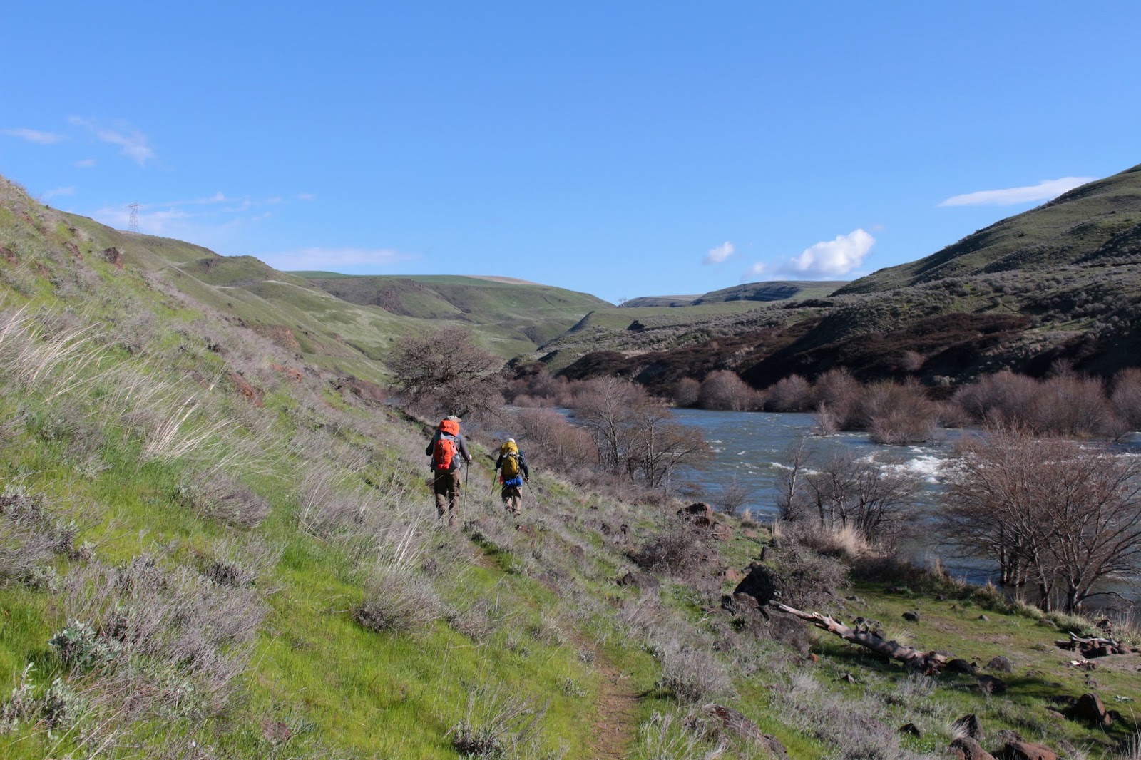
Shining river


This time of year, the hikes tend to take place at lower elevations or on the coast, because the mountains are still cloaked in heavy snow. As far as backpacking in the mountains right now: forget about it! But we too, just like the lone trillium at Tahkenitch Dunes, also need to bloom, hiking-wise. So, where to go? And yes, the title of this blog probably telegraphed the answer. But hey, the question was meant to be rhetorical, anyway.

A stand of willows wait for spring
The Deschutes River runs south to north in central Oregon, before joining up with the Columbia River near The Dalles. Being in the Cascades Range rain shadow, the terrain tends to be on the arid side, especially the closer it gets to the Columbia River. Over the ages, the river has carved a canyon approximately 2,000 feet deep into the lava and volcanic ash comprising the Columbia Plateau. An abandoned railway on the east side of the river has been converted to the Deschutes River Trail and for all appearances, the trail looks like your basic gravel road. You probably don't want to hike here in summer as it can become quite hot, making the rattlesnakes and ticks happy and plentiful. But in spring, when trilliums start blooming on the west side of the Cascades, now that is the time to visit the Deschutes River Recreation Area. 

Lots of orange rock on this trip
This time of year, the weather is cooler than the coming summer inferno, and the trail is blessedly free of snow. And because the flowers told us to go ahead do this: Lane, Lindsay, and I hoisted our backpacks for the first time this year and hit the trail for a three-day backpack trip up the Deschutes River.


Day 1

Starting out on a chilly afternoon
The trail began at the Deschutes River State Recreation Area park and campground, located at the confluence of the Deschutes and Columbia Rivers. From the picnic area, we were faced with three choices for hiking trails and pay attention kids: there will be a pop quiz in the morning. The Deschutes River Trail runs high up the canyon and as stated previously, is pretty much a gravel road. The Middle Trail runs below the Deschutes River Trail, and is a "real" trail that runs along a terraced cliff overlooking the river. The River Trail follows the river right along the river's edge, the water virtually lapping at hiker's feet. We chose the River Trail simply because it allowed us to postpone the eventual climb up from the picnic area to the Deschutes River Trail. But then again, we are brave that way.

Trees go wading in the river
The Deschutes was flowing wide and fast; and much higher than normal too, if trees standing in the water like so many arboreal wading birds were any indication. Because it was March, the hills were either green with sprouting grass or orange from sprouting basaltic rock, although the orange rock sprouts all year and not just in March. While trees were in abundance immediately next to the river, there were no trees at all away from the river, and the surrounding hills were as bald as my grandmother. Our little trail perambulated through the tall grasses growing next to the mighty Deschutes.

The Great Sphinx of Deschutes 
On the face of it, the day was sunny and cloudless. And yes, that did make for nice photos and all, but a chill headwind was blowing down the canyon and it was not as warm as the photos make it seem. There should be disclaimer in the lower right corner of each photo: "Warning! Objects may be colder than they appear" The terrain sloped steeply uphill away from us and rock formations loomed overhead. In many respects, Lane and I were reminded of last year's Honeycombs backpack trip.

The trail generally stayed high above the river


At the two-mile mark, we split away from the River Trail and headed uphill to the Deschutes River Trail. The former railway bed is remarkably level except for one section where the roadway drops into and then climbs out of Gordon Canyon. There used to be a trestle bridge spanning the canyon and had the bridge still been in existence, there'd have been no uphill hiking at all. As a side note, there'd have been no whining and/or complaining about the uphill experience, either.

The rock formations were pretty neat
Once on the gravel road, the route stayed high above the river and provided stunning views of the river and canyon scenery. Because of the proximity to the Columbia Gorge's ample hydroelectric projects, you never really get away from massive power lines but they tend to be seen in the distance and except for a couple of instances, generally are not intrusive. 

Practice run for the upcoming solar eclipse
Because of the long drive from Roseburg, we had started hiking mid-afternoon and the sun sank behind the canyon walls just before the 6 mile mark. The very second the canyon plunged into shade, the air became as cold as an ex-wife's stare. The state park system has installed primitive bathrooms every two miles or so, and we camped near (but upwind of) the privy. You can avoid using the bathrooms but if you do then you have to pack your "stuff" out. Not that we are particularly dainty, but we had no problem availing ourselves of the facilities in order to avoid that odious and odiferous mandate. 

Train!
Part of the history of the Deschutes River involved one of the United States's last great train wars: the Deschutes River Railroad War, a bitter contest fought between the Oregon Trunk Railroad and the Deschutes Railroad. Rival railroad lines were built, one on each side of the river, and railway workers were maimed and killed in a series of violent incidents. Things are more peaceful nowadays and while we hiked on the abandoned Oregon Trunk Railroad railway bed, long freight trains chugged up and down the Burlington Northern railroad line on the western bank of the Deschutes without dynamite or gunfire being involved.

Day2

Dawn comes to our bathroom
Day 2 could have easily been dubbed Scenery Day. It also could have been dubbed History Day, too, as both history and scenery are an integral part of the Deschutes River Trail experience. After striking camp, we walked up to the trail and watered up at a nearby trickling spring. After a short hike, the canyon narrowed and the river snaked spectacularly below, but we were more interested in an old wooden box car perched right on the edge of the trail. We had walked less than half a mile and were already enjoying scenery and  history, totally in keeping with this portion of the trail.

A really big tent
The box car would probably be a nifty place to camp in inclement weather but this day was wonderfully sunny without the cold wind from the day before. A backpacking group of about 6 had spent the night inside, despite the lack of rain. They said it was comfortable, except for the mice running over backpackers trying to sleep.

The scenery was fantastic
Shortly past the box car, two posts next to the river marked the Free Bridge site. There used to be a rickety dirt road running down to and across the river. The old road bed was still visible on the other side, inscribing a steep diagonal line across the face of a formidable treeless ridge. Eeh! The thought of taking a car down or up that road was enough to give one the heebie-jeebies. The next day, we would see a mountain biker toiling up the rough track, giving us heebie-jeebies all over again, not to mention a whole lot of sympathy for the mountain biker.

Posts to nowhere
As we hiked upriver some more, leaving Free Bridge behind, the canyon widened a bit and offered sweeping vistas of windblown ridges, hills, and cliffs. On one bald hill, a single stunted tree grew, which constituted a forest in these parts. And always, the Deschutes River coursed below in wide snaking curves, the water's surface glinting silver in the morning sunlight.


The canyon rim was 2,000 feet above us
There were places where the grassy slopes were supplanted by walls of sun-baked orange rock formations. Definitely cliffy, the canyon rim could be seen on occasion, about 2,000 feet above us. Crows played little crow games and noisy cawings echoed between the russet-colored pyramids flanking the route.


Here come the building inspectors!
About 10 miles from the trailhead, the terrain became somewhat more "farmy" which is probably why the historical Harris Homestead is sited here. Sharing the same surname as the homestead's pioneers, Lane put forth the dubious claim that this was the ancestral home of his tribe. The old farmhouse on the homestead is in quite a tatterdemalion state, being only a few more winters away from total collapse. The rickety structure leaned to the right and the back wall had peeled off. Inside, a brick chimney drunkenly leaned against a wall for support, while stairs led to living quarters that had not been lived in for decades. Hmm, maybe it does belong to Lane's people after all.

Not what it used to be
Surrounding the old farm house are old corrals and pens, harkening back to the era when the homestead was a working ranch. Further up the trail was another abandoned building that looked like it could have been a small railway depot or station, emphasis on "small". It's no Grand Central Station, for sure. This small building was crudely wired for electricity and seeing the cables criss-crossing the wall gave us another case of heebie-jeebies. Back in the day, electricians were apparently unencumbered by building codes or general all -around electrical safety.

The lone remaining water tower
Just past the maybe-a-station, a weathered wooden water tower towered over the trail. We had arrived at Harris Canyon, carved out by Harris Creek. The Deschutes River ran next to the trail and split to go around yes, you guessed it: Harris Island. Anyway, here in Harrisland, a gravity feed from Harris Creek kept the water tower filled. Built to service the trains chugging along the Deschutes River railroads back in the early 1900's, this particular water tower is the only survivor of the 8 towers constructed for that purpose. However, the tower no longer can contain water as woodpeckers have pecked the wall full of holes, but at least the little peckers are happy.

Time to howl with the coyotes
Next to the water tower's stout timbers, we set up camp underneath some rare shady trees at the river's edge. The campsite proffered up a marvelous view of an abrupt ridge that amazingly enough, was not named Harris Ridge. A group of passing hikers pointed out, high up on the ridge crest, some light tan specks barely visible to the naked eye. Yup, we were looking at a small herd of bighorn sheep, something we never see in our Douglas County environs; for us, it was kind of like a field trip to the zoo. The rest of the day was spent lazing in the shady campsite, watching the sheep-dots above, as afternoon quietly slipped into sunset.

Day 3 

Take us home, Lindsay
The plan for the third day was to head back down the river and camp within a few miles of the trailhead. That would make for an easy out hike on the 4th day and a relatively early arrival in Roseburg. But the best made plans and all that...Day 3 was a Saturday and the Deschutes River State Recreation Area is close to Portland. So, the trail naturally was swarming with hikers, backpackers, and mountain bikers: all out to enjoy the spring weather on the Deschutes. At Gordon Canyon, our intended campsite, there were about a dozen tents full of noisy teenagers and that cinched the deal: we just hiked all the way to the trailhead and put out a day early. 

We felt walled in
Probably just as well we hoofed the nearly 12 miles back to the car, the sunny weather from Day 2 was replaced by clouds and a blustery wind. Occasional rain drops fell from the sky and it sure felt like a storm was blowing in. But all the great scenery on a wonderfully level trail from the first two days was still there and we got to enjoy it all over again. 

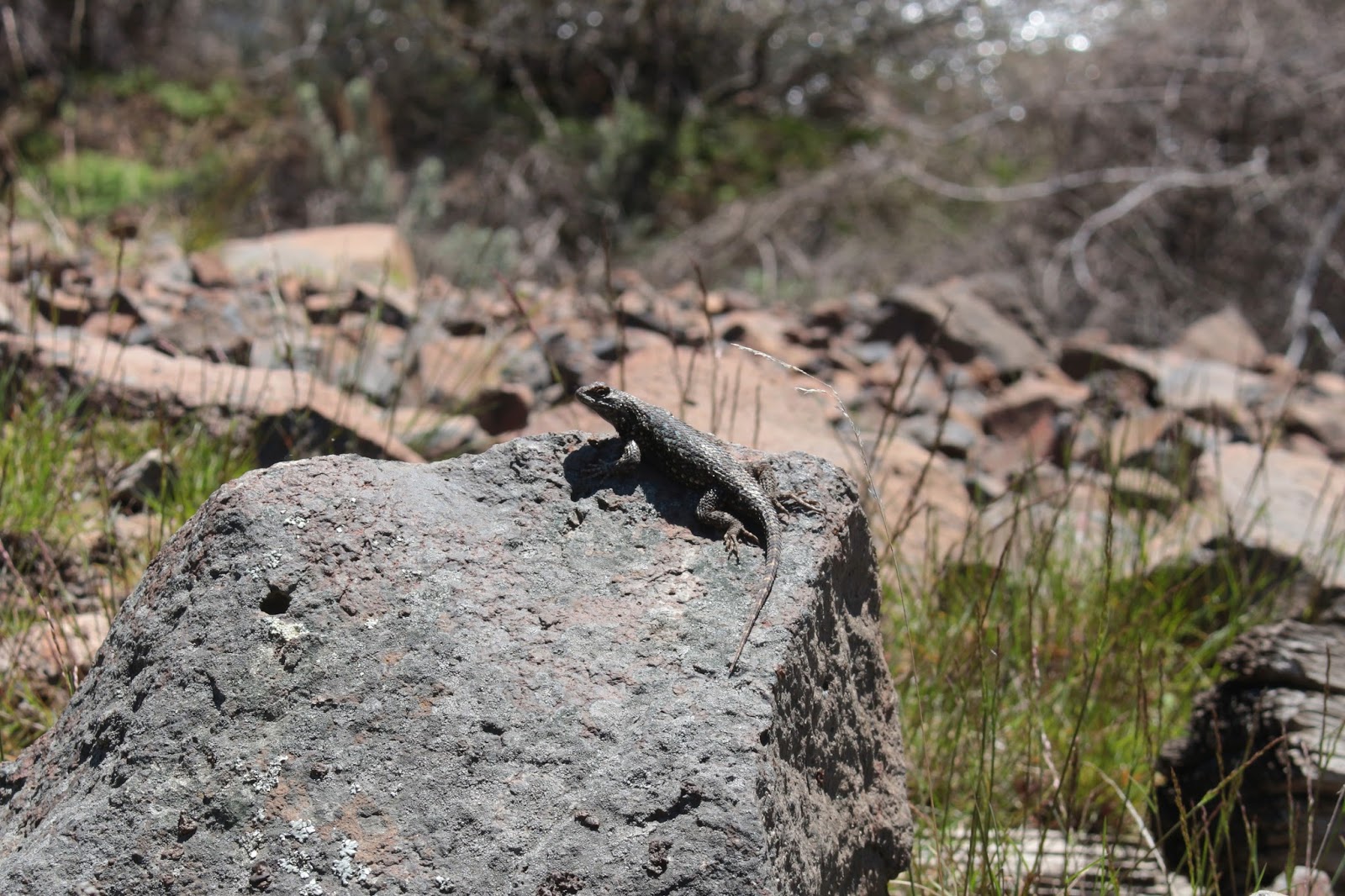
A lizard enjoys the sun
Passing mountain bikers regaled us with tales of rattlesnakes seen on the trail but the only reptile besides Lane that we spotted, was a blue-belly lizard sunning itself on a boulder. The dearth of venomous vipers meant that we did not have to hear Lane scream like a little girl; or me shouting out "Yowzah!" (in more manly fashion); or otherwise relive our respective snake moments from our Honeycombs backpack last year. We whiled away at least a mile of trail recounting the details of those two snake encounters to Lindsay.

Panorama at Gordon Canyon
After making the decision to eschew camping and fraternizing with the aforementioned tented adolescent hordes ensconced at Gordon Canyon, we stayed on the Deschutes River Trail which was new trail for us, seeing as how we had come in on the River Trail. The trail dipped in and out of Gordon Canyon's canyon, and after all those level miles, our legs were quite shocked to have to hike uphill, they barely remembered how to do that. They didn't like it, either. 

On a real trail, briefly
The last few miles were more of the same what with the trail contouring the canyon walls high above the river. Wide sweeping views, spectacular scenery, yada yada....Actually, that sounds kind of jaded but really, the scenery was pretty cool, especially when we rounded a bend and could actually see the Deschutes River meeting with the much larger Columbia. Where rogue fruit trees bloomed next to the gravel road, we grabbed the footpath down to the picnic area and just like that, our 24 mile hike hike was over.

We always come out early!
On the way back, I texted Dollie we had put out a day early and she replied "You always come out a day early, I expect it, now!" Lane texted Ceresse and she replied "You always come out early!" Not sure what Lindsay's wife thinks, but apparently Lane and I are predictable, unlike the Oregon weather.

Sunset at Harris Homestead
For more pictures of this trip, see the following Flickr albums:

Day1

Day2

Day3


Saturday, August 22, 2015

Bandon to Port Orford backpack

In a sense, this summer hike on the coast had a lot do with winter. Last January I was hiking in the Cone Peak area and there's no way a 5,600 foot peak should have been that accessible in the middle of winter, at least not without snowshoes and a whole bunch of warm winter wear. On that hike, the only snow visible for miles and miles were on the Three Sisters and Mount Jefferson, four white pimples surrounded by a vast tract of dark and snowless forest. I remember thinking "This is so not good", as surely the lack of snow was a harbinger of what surely would be a merciless fire season.

Feet got wet at China Creek
While I was correct in my presumption, we sort of skated here in southern Oregon, fire-wise. Yes, we did have wildfires but none were as catastrophic as they could have been. On the other hand, Washington, Idaho, and eastern Oregon caught the flaming brunt of a snowless winter as the fires there were huge and numerous. One of those fires, the Eagle Fire, caused us (Lane, Dale, and I) to scratch a 50'ish mile backpack in the Wallowa Mountains. We didn't want to backpack in the southern Cascades either, as the fires here were pretty much filling the air with particulate matter and turning the blue sky a dirty shade of gray-brown. It'd be like backpacking in Los Angeles, Tokyo, or Mexico City, the air was so dirty. By default, we headed to Bandon for a shorter, easier, and presumably more smoke-free hike.

All the sand you could ever want to walk on
The Oregon Coast Trail is on my list of things to do but one of the drawbacks to the OCT is that significant portions of the route are on roadways. However, the longest section of roadless hiking on the OCT is the 27 miles from Bandon to Port Orford. Highway 101 heads inland and the land between the highway and the ocean is mostly undeveloped. By hiking the beach from Bandon to Floras Lake, hikers can get a taste of what a truly wild beach can be like. Hikers can also get a taste of what 3 days of walking on soft sand can be like and that's not all that much of a good thing. It's both the best and worst of beach hiking.

This is going to be easy!
We started at mid-day because the restaurant where we ate breakfast was incredibly slow. Good thing we had the time! At any rate, we set out from the Inn at Face Rock (Thanks, Inn, for letting us park our car there) and sallied forth onto the beach, heading due south. The sand at Bandon Beach was firm and hard packed and we made rapid progress underneath a cloudless blue sky.  Hey, this was going to be an easy hike!

My view, for the next 20 miles
Things changed when we hit the mouth of the New River; well, where the mouth normally would be. In this dry summer, the mouth was closed shut by a formidable sand bar and the New petered out within sight of the Pacific Ocean. And just past the New River, the sand changed from hard to soft. Our legs immediately started screaming in agony from the soft sand walking.The best way I can describe it is that walking on soft sand uses the same muscle groups as that evil stair-stepper at the gym, and with the same result: burning quads and calves. The good news was that we would feel the burn for only the next 20 miles or so!


Once past photogenic Haystack Rock, it was nothing but empty beach for the rest of the day. Just us, gulls, and flocks of sanderlings running comically in front of the incoming waves. We were excited to find a few pristine and perfectly intact sand dollars but that soon lost luster as there were like millions of sand dollars strewn about, all in mint condition. 

A log gets slapped by the sea
We were walking through the snowy plover habitat and hikers are required to walk on wet sand only. Amazingly, about 10 miles of dry sand had been roped off all the way from the New River to the public park with the rather unwieldy name of New River Area of Critical Environmental Concern, a few miles north of Floras Lake.

Exhaustion at the New River (photo by Lane)
A sign post affixed to the top of the beach foredunes marked the location of the BLM "campground". The amenities were rather sparse, consisting of a few planks upon which to sit, acres of grass and sand and most importantly, official permission to pitch a tent. We didn't care about the lack of comfort as we were just happy to drop our packs and quit walking on soft sand. The New River was a short walk away and we replenished our water supply. The day had been sunny and naturally, we were treated to a superb sunset, our reward for all that hard work. Now that I think about it, we could have enjoyed the same sunset seated in a car parked at Face Rock but that's beside the point.

Dale, Lane, and Barbie


The second day dawned cold and foggy. While it wasn't raining, the air had that liquidity to it that left us all wet anyway. If anything, the sand had gotten softer than the day before. And just like the day before, the sand sloped steeply into the ocean while on the landward side, a large sand bank had been created by wave action. Trying to be good citizens and walk on the wet sand was exceedingly difficult as we occasionally had to run from large waves only to find ourselves trapped by the sand bank. Our feet got wet and we thought the ocean quite rude.

Yup, the sand is soft
Eventually, we cheated and walked atop the sandy cliff. We periodically found veins of hard sand and chased them like miners following a depleting vein of gold. From the first "hey, I found hard sand!" followed immediately by so-called friends cutting in front and chewing up the hardpack, we learned to keep our hard-sand discoveries to ourselves. However, we learned to watch our comrades' feet and if any of us was walking with a smile on his face, two others cut in front and took the smile away. So we learned to fake walking in soft sand even if the sand was pleasantly firm. We learned a lot about ourselves and our so-called friends as this sand walking turned out to be a pretty cutthroat endeavor.  

It's a tube thingy!
The beaches here are a beachcomber's delight and we found skinned baseballs, petrified wood, a boat, floats, and a rock that looked like the second coming of Elvis Presley (it's a miracle!). Lane was particularly excited when he found a metal tube that from his Navy days, he recognized as a container for sonobuoys. Me, I would have just called it a tube thingy, without Lane's vast reservoir of knowledge about obscure tube thingies. Thanks, Lane!  

We tried walking in the grass for a bit...didn't work!
A moment of levity occurred when, tired of sand walking, we decided to attempt hiking through the grasses behind the dunes. Through the fog, I could see a herd of elk walking in the pasturelands along the New River. But then Lane said they didn't really move like elk and on second glance, I agreed. Must be cows then but as they scrambled up and down the banks of the New River, they seemed way too agile for cattle. What were those things? As we pondered that question, totally mystified, the faint sound of sheep bleats carried through the mist. Well, it sure is easy to mistake sheep for cattle or elk!

Floras Lake
At Floras Lake, we stopped to replenish our water. I use purification tablets while Lane and Dale use water pumps. Naturally, I was done before they finished. I sat down in the sand and reclined against my pack and totally involuntarily, my eyes rolled up and I promptly dropped off to an accidental sleep. I woke up with a start, totally disoriented with no idea how long I'd slept or whether the guys had left me behind.  No worries, a pair of snores behind me gave it away; they too had checked out. Happy now, I re-closed my eyes and fell into another restful slumber. Afterwards, when we all woke up and resumed hiking, I told Dale and Lane that we had just slept together and I was warned that statement had better not appear in my newspaper story. But they didn't say anything about my blog!

A real trail is cause for celebration
Fully rested, we really enjoyed the hike from Floras Lake to Blacklock Point. We were hiking on the Oregon Coast Trail and best of all it was on a real trail with real trail tread underneath our very real feet. The path cut through a dense coastal forest and we grazed upon ripe huckleberries as we hiked. Several miles later we set up camp in the trees above Blacklock Point. 

Sunset at Blacklock Point
The cloud cover had taken away the sunset but amazingly, the sun dropped through a hole in the cloud cover and Lane and I enjoyed a quick photo shoot of the sunset. Unfortunately, a chill wind was blowing and after several minutes, Lane and I sought shelter in our respective tents. That night, some creature was in our campsite and was croaking "Raik,,,raik,,,raik,," in a strange helium-tinged cartoon voice; it was as if it was trying to talk to us. Maybe it was expressing appreciation of Cape Blanco's lighthouse beam sweeping through the trees every 30 seconds or so while the wind stirred the trees overhead.

On our way to the Sixes River


Day 3 started out misty but the fog burned off by mid-morning. My recollection of Day 3 was the day was bright and sunny but looking at my pictures later, the mist never really fully left. We set out on the scenic beach arcing towards Cape Blanco and as usual, we were soon grousing about hiking on soft sand. Desperate men do desperate things so about halfway down the beach, we beat through the beachgrass and found a cow trail that allowed us to walk on real ground and make quick pain-free progress to the Sixes River.

Lane fords the Sixes River
The Sixes was still flowing to the sea (this time of year, it's not uncommon to find the Sixes dammed by a sand bar) and it was a shallow wade across. None of us felt like walking on the beach to Cape Blanco so we grabbed the Oregon Coast Trail which climbed up the bluffs overlooking the bay. Astute readers will discern we were at this point, harboring an irrational animus towards soft sand. At any rate, the OCT wended its way through a shady coastal forest before delivering us to the parking lot next to the Cape Blanco Lighthouse. From there it was another short forest walk down to the beach on the south side of Cape Blanco.

Freaking hilarious!
Several miles later (on soft sand, too, darn it) we arrived at the Elk River, our intended campsite. The wind was really blowing but fortunately was at our backs. There were no trees at the mouth of the Elk and we'd have to pitch our tents on the sand in the wind, a rather dubious proposition at best. So, after a quick impromptu confab, we decided to hike the remaining three miles to our car. Dale and I crossed the Elk close to the ocean, where the river fanned out and made the crossing relatively shallow. Lane, on the other hand, crossed slightly inland and entertained Dale and I as he flailed his way through a waist deep river.

Please make the soft sand stop
The last three miles were in soft sand, but what else was new. I think I was getting into sand shape because while the going was slow and trudging, I had plenty of energy left when we reached the end of the hike. Afterwards, we stopped for dinner and the waitress told us the special was a turkey sandwich and we all flinched at the "sand" in "sandwich". I think we all have post-trail sand syndrome, or PTSD for short, but it sure beat walking in a forest fire.

This hike was golden
For more pictures of this trip, please visit the Flickr album.