Showing posts with label columbia river. Show all posts

Thursday, March 30, 2017

Deschutes River Trail

It is said that March comes in like a lion and goes out like a lamb. Well, if it comes in like a lion it must be one wet lion because as I've stated several times before in my blog, it's been raining. A lot. A lot lot. But lately, the weather has been dropping little hints of spring and besides which, I saw a trillium on my last hike at Tahkenitch Dunes. We should listen to the flowers because they certainly know when spring is coming!

Shining river


This time of year, the hikes tend to take place at lower elevations or on the coast, because the mountains are still cloaked in heavy snow. As far as backpacking in the mountains right now: forget about it! But we too, just like the lone trillium at Tahkenitch Dunes, also need to bloom, hiking-wise. So, where to go? And yes, the title of this blog probably telegraphed the answer. But hey, the question was meant to be rhetorical, anyway.

A stand of willows wait for spring
The Deschutes River runs south to north in central Oregon, before joining up with the Columbia River near The Dalles. Being in the Cascades Range rain shadow, the terrain tends to be on the arid side, especially the closer it gets to the Columbia River. Over the ages, the river has carved a canyon approximately 2,000 feet deep into the lava and volcanic ash comprising the Columbia Plateau. An abandoned railway on the east side of the river has been converted to the Deschutes River Trail and for all appearances, the trail looks like your basic gravel road. You probably don't want to hike here in summer as it can become quite hot, making the rattlesnakes and ticks happy and plentiful. But in spring, when trilliums start blooming on the west side of the Cascades, now that is the time to visit the Deschutes River Recreation Area. 

Lots of orange rock on this trip
This time of year, the weather is cooler than the coming summer inferno, and the trail is blessedly free of snow. And because the flowers told us to go ahead do this: Lane, Lindsay, and I hoisted our backpacks for the first time this year and hit the trail for a three-day backpack trip up the Deschutes River.


Day 1

Starting out on a chilly afternoon
The trail began at the Deschutes River State Recreation Area park and campground, located at the confluence of the Deschutes and Columbia Rivers. From the picnic area, we were faced with three choices for hiking trails and pay attention kids: there will be a pop quiz in the morning. The Deschutes River Trail runs high up the canyon and as stated previously, is pretty much a gravel road. The Middle Trail runs below the Deschutes River Trail, and is a "real" trail that runs along a terraced cliff overlooking the river. The River Trail follows the river right along the river's edge, the water virtually lapping at hiker's feet. We chose the River Trail simply because it allowed us to postpone the eventual climb up from the picnic area to the Deschutes River Trail. But then again, we are brave that way.

Trees go wading in the river
The Deschutes was flowing wide and fast; and much higher than normal too, if trees standing in the water like so many arboreal wading birds were any indication. Because it was March, the hills were either green with sprouting grass or orange from sprouting basaltic rock, although the orange rock sprouts all year and not just in March. While trees were in abundance immediately next to the river, there were no trees at all away from the river, and the surrounding hills were as bald as my grandmother. Our little trail perambulated through the tall grasses growing next to the mighty Deschutes.

The Great Sphinx of Deschutes 
On the face of it, the day was sunny and cloudless. And yes, that did make for nice photos and all, but a chill headwind was blowing down the canyon and it was not as warm as the photos make it seem. There should be disclaimer in the lower right corner of each photo: "Warning! Objects may be colder than they appear" The terrain sloped steeply uphill away from us and rock formations loomed overhead. In many respects, Lane and I were reminded of last year's Honeycombs backpack trip.

The trail generally stayed high above the river


At the two-mile mark, we split away from the River Trail and headed uphill to the Deschutes River Trail. The former railway bed is remarkably level except for one section where the roadway drops into and then climbs out of Gordon Canyon. There used to be a trestle bridge spanning the canyon and had the bridge still been in existence, there'd have been no uphill hiking at all. As a side note, there'd have been no whining and/or complaining about the uphill experience, either.

The rock formations were pretty neat
Once on the gravel road, the route stayed high above the river and provided stunning views of the river and canyon scenery. Because of the proximity to the Columbia Gorge's ample hydroelectric projects, you never really get away from massive power lines but they tend to be seen in the distance and except for a couple of instances, generally are not intrusive. 

Practice run for the upcoming solar eclipse
Because of the long drive from Roseburg, we had started hiking mid-afternoon and the sun sank behind the canyon walls just before the 6 mile mark. The very second the canyon plunged into shade, the air became as cold as an ex-wife's stare. The state park system has installed primitive bathrooms every two miles or so, and we camped near (but upwind of) the privy. You can avoid using the bathrooms but if you do then you have to pack your "stuff" out. Not that we are particularly dainty, but we had no problem availing ourselves of the facilities in order to avoid that odious and odiferous mandate. 

Train!
Part of the history of the Deschutes River involved one of the United States's last great train wars: the Deschutes River Railroad War, a bitter contest fought between the Oregon Trunk Railroad and the Deschutes Railroad. Rival railroad lines were built, one on each side of the river, and railway workers were maimed and killed in a series of violent incidents. Things are more peaceful nowadays and while we hiked on the abandoned Oregon Trunk Railroad railway bed, long freight trains chugged up and down the Burlington Northern railroad line on the western bank of the Deschutes without dynamite or gunfire being involved.

Day2

Dawn comes to our bathroom
Day 2 could have easily been dubbed Scenery Day. It also could have been dubbed History Day, too, as both history and scenery are an integral part of the Deschutes River Trail experience. After striking camp, we walked up to the trail and watered up at a nearby trickling spring. After a short hike, the canyon narrowed and the river snaked spectacularly below, but we were more interested in an old wooden box car perched right on the edge of the trail. We had walked less than half a mile and were already enjoying scenery and  history, totally in keeping with this portion of the trail.

A really big tent
The box car would probably be a nifty place to camp in inclement weather but this day was wonderfully sunny without the cold wind from the day before. A backpacking group of about 6 had spent the night inside, despite the lack of rain. They said it was comfortable, except for the mice running over backpackers trying to sleep.

The scenery was fantastic
Shortly past the box car, two posts next to the river marked the Free Bridge site. There used to be a rickety dirt road running down to and across the river. The old road bed was still visible on the other side, inscribing a steep diagonal line across the face of a formidable treeless ridge. Eeh! The thought of taking a car down or up that road was enough to give one the heebie-jeebies. The next day, we would see a mountain biker toiling up the rough track, giving us heebie-jeebies all over again, not to mention a whole lot of sympathy for the mountain biker.

Posts to nowhere
As we hiked upriver some more, leaving Free Bridge behind, the canyon widened a bit and offered sweeping vistas of windblown ridges, hills, and cliffs. On one bald hill, a single stunted tree grew, which constituted a forest in these parts. And always, the Deschutes River coursed below in wide snaking curves, the water's surface glinting silver in the morning sunlight.


The canyon rim was 2,000 feet above us
There were places where the grassy slopes were supplanted by walls of sun-baked orange rock formations. Definitely cliffy, the canyon rim could be seen on occasion, about 2,000 feet above us. Crows played little crow games and noisy cawings echoed between the russet-colored pyramids flanking the route.


Here come the building inspectors!
About 10 miles from the trailhead, the terrain became somewhat more "farmy" which is probably why the historical Harris Homestead is sited here. Sharing the same surname as the homestead's pioneers, Lane put forth the dubious claim that this was the ancestral home of his tribe. The old farmhouse on the homestead is in quite a tatterdemalion state, being only a few more winters away from total collapse. The rickety structure leaned to the right and the back wall had peeled off. Inside, a brick chimney drunkenly leaned against a wall for support, while stairs led to living quarters that had not been lived in for decades. Hmm, maybe it does belong to Lane's people after all.

Not what it used to be
Surrounding the old farm house are old corrals and pens, harkening back to the era when the homestead was a working ranch. Further up the trail was another abandoned building that looked like it could have been a small railway depot or station, emphasis on "small". It's no Grand Central Station, for sure. This small building was crudely wired for electricity and seeing the cables criss-crossing the wall gave us another case of heebie-jeebies. Back in the day, electricians were apparently unencumbered by building codes or general all -around electrical safety.

The lone remaining water tower
Just past the maybe-a-station, a weathered wooden water tower towered over the trail. We had arrived at Harris Canyon, carved out by Harris Creek. The Deschutes River ran next to the trail and split to go around yes, you guessed it: Harris Island. Anyway, here in Harrisland, a gravity feed from Harris Creek kept the water tower filled. Built to service the trains chugging along the Deschutes River railroads back in the early 1900's, this particular water tower is the only survivor of the 8 towers constructed for that purpose. However, the tower no longer can contain water as woodpeckers have pecked the wall full of holes, but at least the little peckers are happy.

Time to howl with the coyotes
Next to the water tower's stout timbers, we set up camp underneath some rare shady trees at the river's edge. The campsite proffered up a marvelous view of an abrupt ridge that amazingly enough, was not named Harris Ridge. A group of passing hikers pointed out, high up on the ridge crest, some light tan specks barely visible to the naked eye. Yup, we were looking at a small herd of bighorn sheep, something we never see in our Douglas County environs; for us, it was kind of like a field trip to the zoo. The rest of the day was spent lazing in the shady campsite, watching the sheep-dots above, as afternoon quietly slipped into sunset.

Day 3 

Take us home, Lindsay
The plan for the third day was to head back down the river and camp within a few miles of the trailhead. That would make for an easy out hike on the 4th day and a relatively early arrival in Roseburg. But the best made plans and all that...Day 3 was a Saturday and the Deschutes River State Recreation Area is close to Portland. So, the trail naturally was swarming with hikers, backpackers, and mountain bikers: all out to enjoy the spring weather on the Deschutes. At Gordon Canyon, our intended campsite, there were about a dozen tents full of noisy teenagers and that cinched the deal: we just hiked all the way to the trailhead and put out a day early. 

We felt walled in
Probably just as well we hoofed the nearly 12 miles back to the car, the sunny weather from Day 2 was replaced by clouds and a blustery wind. Occasional rain drops fell from the sky and it sure felt like a storm was blowing in. But all the great scenery on a wonderfully level trail from the first two days was still there and we got to enjoy it all over again. 

A lizard enjoys the sun
Passing mountain bikers regaled us with tales of rattlesnakes seen on the trail but the only reptile besides Lane that we spotted, was a blue-belly lizard sunning itself on a boulder. The dearth of venomous vipers meant that we did not have to hear Lane scream like a little girl; or me shouting out "Yowzah!" (in more manly fashion); or otherwise relive our respective snake moments from our Honeycombs backpack last year. We whiled away at least a mile of trail recounting the details of those two snake encounters to Lindsay.

Panorama at Gordon Canyon
After making the decision to eschew camping and fraternizing with the aforementioned tented adolescent hordes ensconced at Gordon Canyon, we stayed on the Deschutes River Trail which was new trail for us, seeing as how we had come in on the River Trail. The trail dipped in and out of Gordon Canyon's canyon, and after all those level miles, our legs were quite shocked to have to hike uphill, they barely remembered how to do that. They didn't like it, either. 

On a real trail, briefly
The last few miles were more of the same what with the trail contouring the canyon walls high above the river. Wide sweeping views, spectacular scenery, yada yada....Actually, that sounds kind of jaded but really, the scenery was pretty cool, especially when we rounded a bend and could actually see the Deschutes River meeting with the much larger Columbia. Where rogue fruit trees bloomed next to the gravel road, we grabbed the footpath down to the picnic area and just like that, our 24 mile hike hike was over.

We always come out early!
On the way back, I texted Dollie we had put out a day early and she replied "You always come out a day early, I expect it, now!" Lane texted Ceresse and she replied "You always come out early!" Not sure what Lindsay's wife thinks, but apparently Lane and I are predictable, unlike the Oregon weather.

Sunset at Harris Homestead
For more pictures of this trip, see the following Flickr albums:

Day1

Day2

Day3


Saturday, May 14, 2016

Cottonwood Canyon State Park

Why have I never heard of Cottonwood Canyon? Why haven't I been here already? How come none of my many hiking acquaintances have ever let me know this place existed? Why, why, why? For the life of me I can't understand why the second largest state park southeast of The Dalles is not more renown, because the scenery here is unrelentingly spectacular and world-class.  Take a look for yourself on the park's website: the pictures of the deep canyon with the John Day River snaking its way on the canyon floor have to be seen to believed. Or even better yet, take a look at your humble blogster's photos in Flickr. Sweeping views of the canyon with grassy slopes and basalt walls can be attained by scrambling up to the canyon rim high above the river. The park is fairly undeveloped and is mostly without trails. A couple of formidable side canyons invite cross-country exploration. Poison ivy grows in abundance along the river and the arid hills sport a healthy population of rattlesnakes. I think I might have just answered the question of why the park is not so popular but still, why have I never heard of this place?

Impressive hill across the canyon
The original plan was to backpack in to Lost Corral but the drive took longer than I thought it would. I arrived in either the late afternoon or the early evening, take your pick. At any rate, a slight adjustment was made to the plans in that I set up camp in the hiker/biker campground, in which I was the lone hiker or biker. The short backpack trip plan was amended to two day hikes.

The Murtha Ranch
Since there was a late afternoon or early evening to kill, an enjoyable post-dinner walk of a couple of miles around the park oriented myself to the general layout. From camp, a well-maintained path through the sagebrush linked up with the camp headquarters, where some barns, farm machinery, and outbuildings from the original Murtha Ranch still exist today.  

The canyon is calling to me and I must go...
After exploring the old buildings and rusting farm equipment, a path along the John Day River returned me back to the campground and provided a tantalizing view of the undeveloped canyon calling out to me as the sun set. The campground's official name is Lone Tree Campground and there is actually a large juniper tree there and yes, it is very lone as there are no other trees around for several time zones. Makes one wonder how Baby Juniper came to be born here. 

Morning yoga routine


The next morning dawned overcast and breezy. Rain and thunder was in the forecast but it was still dry early in the morning. After a quick breakfast I headed out to the Lost Corral Trail which runs along the east side of the John Day River for 4.5 miles. The other option was to hike the Pinnacles Trail which does the same thing as the Lost Corral, but on the west side of the river. I liked the sound of "Lost" in Lost Corral so Lost Corral Trail it was.

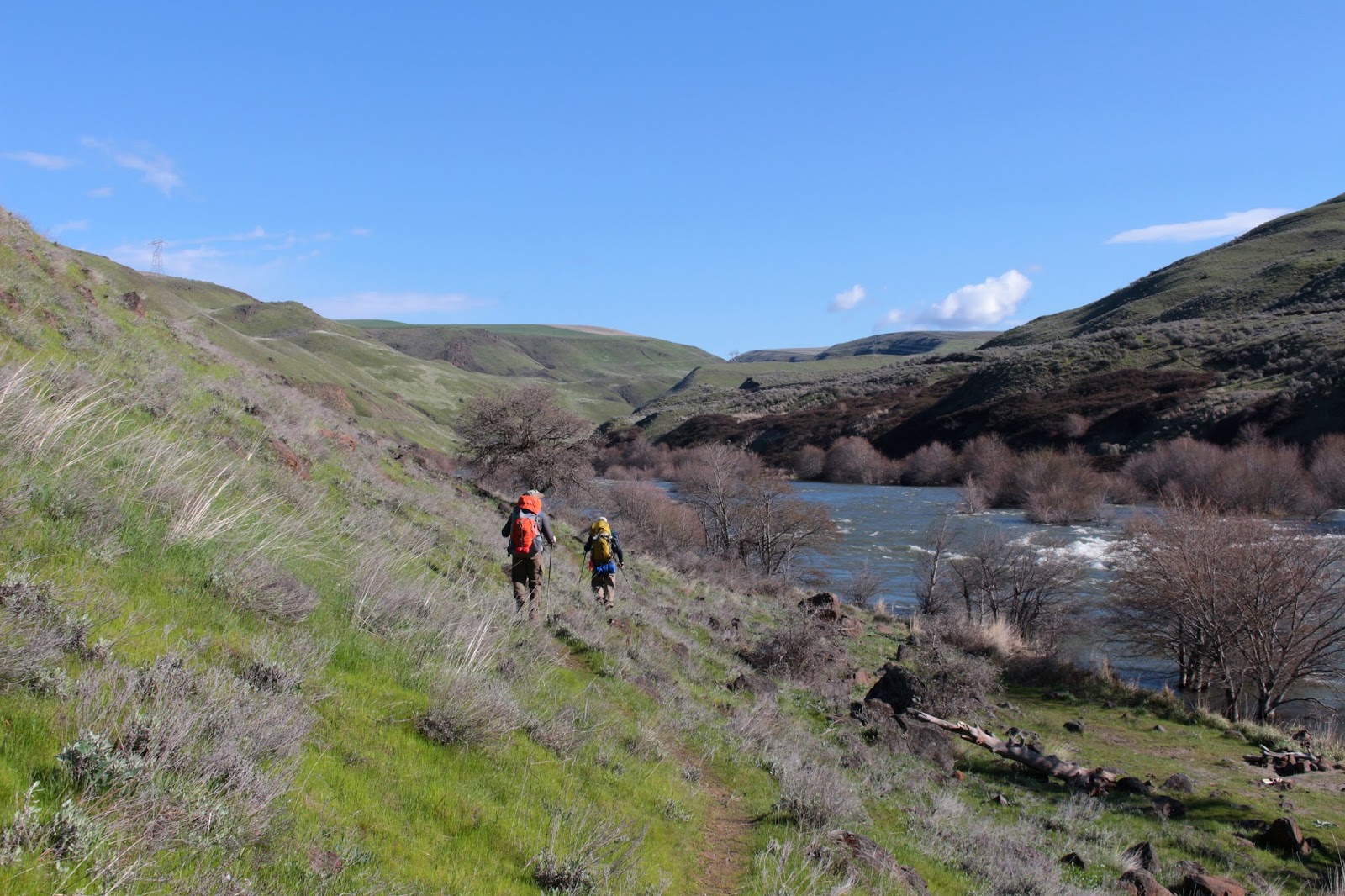
Trail into Cottonwood Canyon


The trail is an old road bed and was pleasantly level. The first mile or so runs past the park buildings and campground and then from there, it was nothing but wild canyon in front of me. I cannot overstate the grandeur of the scenery here. The John Day River silently coursed along on the canyon bottom, flanked by tall walls and bare slopes of basalt. And best of all, the deep and formidable canyon has a Lost Corral Trail to lead hikers into further exploration thereof.
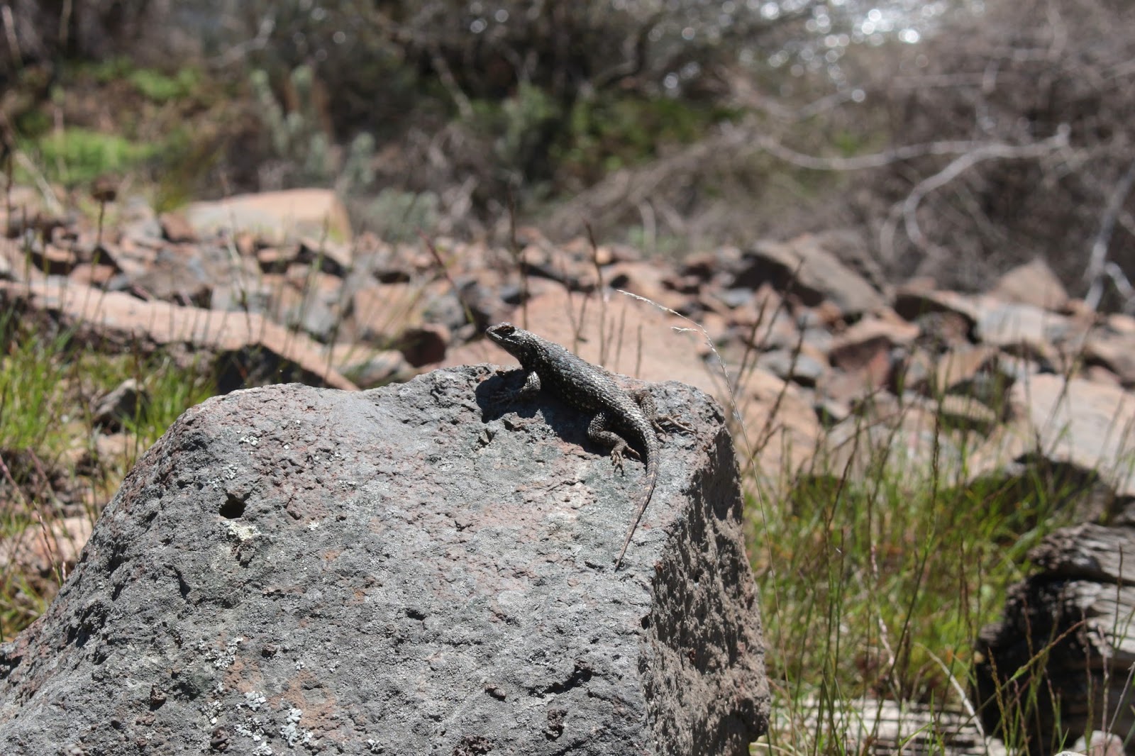
Snake in the grass
Dragonflies and wasps flitted ahead of me as I walked and several gopher snakes were spotted, sunning themselves on the trail. Several times in the outer limits of my peripheral vision, I caught glimpses of scaly creatures slithering into the brush along the trail. I'm still thinking gopher snakes, it makes me feel better that way. I ran into the only other hiker I'd see, a fellow from Portland who bragged about watching carefully for rattlesnakes. "Oh", says I, "care to see the snake you just stepped over?" Yes, he had walked right over a 4 foot gopher snake stretched motionless across the trail. When prodded with the tip of my hiking pole, it quickly disappeared into the sagebrush. After a moment of stunned silence, he said "Wow, if that had been a snake, it would have bit me!"

World-class scenic
The river banks were lush and green and for me, quite exotic as it was all desert vegetation which we don't normally run into in western Oregon. However, I wasn't all that excited about spotting canes of poison ivy. On the landward side of the trail, it was all sagebrush, though. The trail did pass through several pastures, the end result of an ongoing tumbleweed eradication project.

I'll refer you to the previous photo caption
As the miles clicked by, each bend of the river revealed with exquisite slowness, more and more of the canyon. Occasionally, several small side canyons came in at right angles to the main canyon of the John Day. It is possible to explore these canyons and attain the high ridges above, but that will have to wait for a subsequent trip. For today, it was enough to gawk at all the riverine and geologic wonders.

Basalt cliff detail
And speaking of geologic wonders: around the 4 mile mark,  a series of pronounced cliffs rose up from a bend in the river. Beyond the cliffs, large Esau Canyon met up with the John Day. At the base of the cliffs, piles of little bones indicated the presence of raptors nesting in the imposing basalt wall. The cliffs were comprised of layers of layers of basaltic pillars, a formation created when molten basalt cooled and solidified.

View up Esau Canyon
Just beyond the cliffs was the actual corral of Lost Corral, I was only slightly disappointed the corral wasn't all that lost. Spring water ran from a pipe into a pond full of cattails. Although always near the trail, the John Day is not all that accessible due to the thick vegetation flanking the river, so a piped-in spring makes Esau Canyon a very viable backpacking destination. I'll definitely be back!

Dancing shadows and light
On the return, the dark clouds broke up while sunlight and shadows danced a romantic tango upon the hillsides and canyon slopes. Much photography ensued. And of course, the weather turned to the nasty after that little sunny tease. The rain started just as the hike ended and that was it for the rest of the day and night. Let's just say I got plenty of tent time during my stay at Cottonwood Canyon State Park. In the night, the wind picked up and I wondered if it was going to knock my tent down but fortunately, my little Eureka Spitfire held up to the onslaught. And if that wasn't enough, thunder boomed down the canyon and by the time morning came, I waved a white flag of surrender and headed back home to Roseburg a day early. But I'll be back!

Why have I never heard of Cottonwood Canyon before?
For more pictures of this hike, please visit the following Flicker albums:

Cottonwood Canyon State Park

Lost Corral Trail

Saturday, September 13, 2014

A Tale of Two Forts

In 1805, the Lewis and Clark expedition was about to face winter along the Columbia River and the available options for weathering a Pacific Northwest winter were to move upriver, camp on the Washington side of the river, or camp on the Oregon side. Per Wikipedia, Washington's diet was deemed too boring and the weather too rainy (the same still holds true today!). On the recommendation of the local natives, Lewis and Clark opted to build an encampment along Oregon's Lewis and Clark River in what truly was an amazing coincidence.

Encampment detail
Well, the camp was built in an Oregon winter storm which, as we Oregonians know all too well, last about 9 months or so. So the Lewis and Clark expedition soon found the Oregon diet too boring and the weather too rainy (and the same still holds true today!). Apparently they had enough of our weather and they left the area well ahead of schedule (I call it "running away") and their encampment, known as Fort Clatsop, eventually decayed as all things do in Oregon's wet climate. A replica was later built using Lewis and Clark's sketches and that replica burnt down in a 2005 fire, so another replica was subsequently built (but with smoke detectors, this time). I doubt the smoke detectors were in Lewis and Clark's sketches.

Bringing dignity and respect to Sacajawea
Dollie, Mom Gier, and I made a quick trip to visit the fort on our stay in Seaside. The fort is the centerpiece of Lewis and Clark National Historic Park and we toured the small encampment. The austere encampment is not very big and you could almost smell the unwashed bodies in the confined spaces in the wooden structures. Oh, that also might have been me, but I digress. After touring the rustic encampment, Dollie and I took a short walk on some boardwalks to the Lewis and Clark River where the view of Saddle Mountain's tip got my attention because the mountains always call me.

Happy cyclists
The next day, Dollie and I got up early and hopped on the bicycles. We pedaled up the coast highway to Fort Stevens State Park, a rather large park that is part of the Lewis and Clark National and State Park complex. Fort Stevens was built during the Civil War to guard the mouth of the Columbia against the British during the Pig War. I kid you not, we nearly went to war with England over a British pig shot by an American settler, sometimes comedy just writes itself.

What's left of the Peter Iredale
Fortunately, we never quite got around to shooting each other and both sides continued to eat bacon and pork chops with impunity. It was a much more peaceful setting when Dollie and I arrived at the park on a chilly morn. Our first stop was at the wreck of the Peter Iredale, a 1906 shipwreck that is still visible today. Since we were there so early, there weren't many people around which is not a normal occurrence, judging by all the footprints in the sand. It sure makes for nicer photographs without the thundering sandaled hordes intruding into the camera viewfinder.

A ship on the Columbia River
Using a combination of bike trails and roadways, we cycled through low marshlands to the Columbia River.  The river is the Mighty Columbia here, flowing wide, deep, and fast. We watched large cargo ships make their way upriver, presumably on their way to Portland. Fishermen by the pailful were plying their avocation along the sandy river banks.


Jetty at the mouth of the Columbia
The last stop was the south jetty at the actual mouth of the Columbia. Across the river was Cape Disappointment on the Washington state side. I wondered if the cape was named by Lewis and Clark for the boring diet, rainy weather, or maybe the Seattle Mariners. There is a wooden tower that provided a great view of the Oregon coast arcing towards Seaside in the morning sun and we partook thereof. We then completed our 40 mile ride in short order and arrived at the vacation rental as everybody else was just getting up, allowing us to smugly proclaim "40 miles before breakfast, yeah baby!" Our family thinks Dollie and I are nuts.

The wreck of the Peter Iredale
For more pictures of Fort Clatsop and Fort Stevens, just click on the links below.